
Rivers
Park geography
Structured map data, terrain measurements, and environmental classifications for the park landscape
Wigry National Park in Podlaskie Voivodeship: Geographic Profile and Mapped Boundaries
Examine the geographic characteristics and spatial data of Wigry National Park located within the Podlaskie Voivodeship of Poland. This profile covers the recorded 150.86 square kilometer area, boundary coordinates, and the complex distribution of lakes, bays, and woodland habitats defining the regional terrain.

Poland's lake-dominated wilderness in the Masurian Lake District
Wigry National Park
Wigry National Park is a protected area in northeastern Poland spanning approximately 151 square kilometers across the Podlaskie Voivodeship. The park encompasses parts of both the Masurian Lake District and the Augustów Primeval Forest, creating a unique blend of forested wilderness and aquatic ecosystems. Named after Lake Wigry—the largest of the park's forty-two lakes—the park serves as one of Poland's most important wetland conservation areas. The landscape was shaped by glacial activity around 12,000 years ago, resulting in a terrain of lakes, valleys, peat bogs, and forested hills. The park was officially established in 1989 and later designated as a Ramsar wetland site in 2002, recognizing its international significance as a biodiversity hotspot.
- Location
- Poland
- Park type
- National park
- Established
- 1989
- Area
- 150.9 km²
Location overview
Regional placement and geographic status in the Podlaskie Voivodeship
Geographic Position of Wigry National Park in Northeastern Poland
Wigry National Park is situated within the Podlaskie Voivodeship in Poland. The terrestrial protected area is managed entirely within domestic borders without coastal or marine territory.
- Countries
- Poland
- Regions
- Podlaskie Voivodeship
- Primary location
- Podlaskie Voivodeship
- Geographic setting
- Inland
Boundary and coordinates
Mapped spatial geometry and derived area metrics
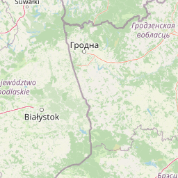
Wigry National Park Boundary Map and Geographic Extent
Interactive boundary mapping provides clear spatial context for the protected area footprint. Accompanying geographic facts outline measured area coverage, coordinate limits, and regional spans.
- Boundary area
- 151.1 km²
- Boundary perimeter
- 105.1 km
- Northernmost point
- 54.1706° N
- Southernmost point
- 53.9743° N
- Easternmost point
- 23.2458° E
- Westernmost point
- 22.9863° E
- Geographic centre
- 54.0442° N, 23.0996° E
- North–south span
- 21.8 km
- East–west span
- 17 km
Elevation and terrain
Mixed relief profiles and recorded water features
Wigry National Park Terrain and Elevation Summary
Recorded park elevation reaches up to one hundred eighty meters across mixed terrain classifications. Individual cards detail named rivers, lakes, and viewpoints located within protected boundaries.
- Maximum elevation
- 180 m
Selected named natural features
Lakes
Pietronajć
Bays
Zatoka Hańczańska
Bays
Zatoka Zadworze
Lakes
Muliczne
Viewpoints
Binduga
Environmental setting
Interpreting forest cover, lake systems, and boreal climate zone records
Wigry National Park Environmental Classifications and Physical Setting
Stored landscape features and habitat types frame the physical setting of Wigry National Park as complementary interpretive categories. Recorded classifications connect directly to relevant atlas destinations across the protected terrain.
- Relief
- Mixed relief
- Climate
- Boreal
- Water
- Major water bodies
- Forest cover
- Mostly forested
- Seasonality
- Seasonal
Landscape features
Lakes · Rivers · Forest · Woodland · Wetland · Bog · Hills
Habitat types
Temperate coniferous forest · Boreal forest · Wetland · Peatland · Riverine habitat · Lacustrine habitat
Park atlas
Trace connected protected landscapes and regional park geography surrounding Wigry National Park
Explore Other National Parks and Protected Areas Near Wigry National Park
Continue your exploration from Wigry National Park to discover other national parks and protected areas across Poland's northeastern region. Compare various protected landscapes, from glacial lake districts to expansive forest wilderness, enhancing your understanding of the broader regional conservation efforts.
Nature reservePodlaskie Voivodeship
Park boundaries overlap#1 closest
Southeast

Ostoja Augustowska Nature Reserve: Protected Forest and Wetland Atlas of Podlaskie
Mapped wilderness corridors in the Polish lowlands
Ostoja Augustowska serves as a major ecological hub in Podlaskie Voivodeship, comprising extensive pine and spruce woodlands linked with diverse peatland systems. The site provides a critical corridor for rare forest wildlife while preserving ancient stands of old-growth timber. Gain insights into the complex geography of this Natura 2000 protected territory through its documented terrain, hydrological networks, and mosaic of rare boreal habitat types.
- Area
- 1,070.69 km²
- Established
- 2009
- Relief
- Lowland
- Climate
- Temperate
National parkPodlaskie Voivodeship
Park boundaries overlap#2 closest
Northeast
Wigierski Park Narodowy: Mapped Protected Landscapes of Northeastern Poland
A regional atlas of postglacial terrain and lake ecosystems.
Wigierski Park Narodowy represents a vital expanse of protected land in the Podlaskie Voivodeship. This profile offers insights into its glacial moraine ridges, kettle hole topography, and the specific distribution of forest-fringed bog habitats that define this distinct segment of the Lithuanian Lake District.
- Area
- 150.898 km²
- Established
- 1989
- Visitors
- 110K annual
- Relief
- Upland
Nature reservePodlaskie Voivodeship
About 14 km away#3 closest
Southeast
Rezerwat przyrody Mały Borek: Pine Bore Forest and Peatland Geography in Podlaskie
Protected nature reserve in the Augustów Primeval Forest
Rezerwat przyrody Mały Borek is a significant nature reserve located in the Podlaskie Voivodeship of Poland. The area is defined by its extensive pine bore forests, central raised bogs, and transition zones of alder swamp. As part of the Natura 2000 network, it provides essential habitat and stands as a key scientific reference for the natural forest landscape of the Augustów Plain.
- Area
- 0.905 km²
- Established
- 1959
- Relief
- Lowland
- Scope
- Terrestrial

Protected landscapePodlaskie Voivodeship
About 18 km away#4 closest
Northwest
Suwalski Park Krajobrazowy: Glacial Terrain and Protected Landscape Atlas
Mapping the post-glacial geography of Podlaskie Voivodeship
Suwalski Park Krajobrazowy represents a highly distinct glacial environment within the Polish lowlands. Explore the distribution of its iconic morainic landforms, extensive boulder reserves, and the deep basin of Lake Hańcza. The park provides critical geographic context for understanding the interplay between ice-transported geology and local hydrological features in northeastern Poland.
- Area
- 63.38 km²
- Established
- 1976
- Relief
- Upland
- Climate
- Temperate

National parkPodlaskie Voivodeship
27 km away#5 closest
Southwest
Biebrza National Park: Protected Fenlands and River Basin Geography in Northeastern Poland
Tracing the largest lowland peat bog complex in the European landscape
Biebrza National Park serves as the premier protected wetland area in Poland, characterized by its vast, intact marshlands and the meandering Biebrza River valley. This geographic profile details the park's critical fen ecosystems, floodplain dynamics, and distinctive habitats that support diverse avian and mammalian populations within the Podlaskie region.
- Area
- 592.23 km²
- Established
- 1993
- IUCN
- II
- Relief
- Lowland
National parkPodlaskie Voivodeship
27 km away#6 closest
South
Biebrzański Park Narodowy: A Protected Wetland Landscape in Podlaskie Voivodeship, Poland
Mapped river valley and peatland geography.
Located in the northeast of Poland, Biebrzański Park Narodowy protects a sprawling, flat basin defined by the slow-meandering Biebrza River. This critical protected area encompasses rare peat bogs, floodplain meadows, and alder carrs, functioning as a vital refuge for wetland species within the broader Podlaskie Voivodeship landscape.
- Area
- 592.23 km²
- Established
- 1993
- Visitors
- 23.2K annual
- Relief
- Lowland
Nature reserveWarmian-Masurian Voivodeship
About 45 km away#7 closest
Northwest
Mechacz Wielki Nature Reserve: Geographic Records of Protected Peatlands in Northeastern Poland
Mapping the raised bog and forest ecosystems of the Romincka Forest.
Mechacz Wielki Nature Reserve represents a critical example of raised bog geography and peat-forming processes in Poland. This record details the reserve as a core feature of the Romincka Forest, focusing on its transition from open moss-dominated surfaces to complex boggy pine forests and wetland habitats. Gain insight into the regional landscape characteristics that shape this unique northeastern protected area.
- Area
- 1.467 km²
- Established
- 1974
- Relief
- Lowland
- Scope
- Terrestrial
National parkLithuania
48 km away#8 closest
East

Dzūkija National Park: Explore Lithuania's Largest Protected Forest and Inland Dune Landscapes
Mapped protected area geography and natural terrain of the Dainava region.
Delve into the protected landscape of Dzūkija National Park, Lithuania's expansive national park renowned for its vast primeval pine forests and extraordinary inland dune formations. This page provides a detailed atlas-style view of the park's mapped boundaries, diverse terrain, and significant natural features, offering insight into its protected territory and regional geographic importance. Examine the unique wetland systems and forest ecosystems that make this a crucial area for protected land discovery.
- Area
- 584.53 km²
- Established
- 1991
- IUCN
- II
- Visitors
- 30K annual
MoriAtlas Explorer
Continue mapping Wigry National Park's Protected Landscape and Regional Geography
Deepen your understanding of Wigry National Park by exploring its precise geographic boundaries and mapped terrain within the Podlaskie Voivodeship. This national park offers a unique window into glacial landforms and vital wetland conservation, providing rich context for understanding its ecological significance. Continue your atlas exploration to trace the park's landscapes and discover its role within Poland's network of protected areas.
Browse next
Global natural geography
Explore related park routes
Explore MoriAtlas Global ParksBrowse All MoriAtlas ParksGlobal Park Map DiscoveryMoriAtlas: Browse All CountriesBrowse All MoriAtlas ContinentsNational Park Environment AtlasGrand Canyon National Park AtlasYellowstone National Park AtlasYosemite National Park Atlas and GeographySerengeti National Park AtlasGalápagos National Park Protected LandscapeBanff National Park Geography and AtlasKruger National Park Atlas EntryUluṟu-Kata Tjuṯa National Park AtlasExplore Uluru-Kata Tjuta National Park GeographyPlitvice Lakes National Park AtlasFiordland National Park Protected LandscapeGreat Smoky Mountains National Park AtlasAfghanistan National Parks and Protected AreasAlbania National Parks and Protected AreasAlgeria National Parks and Protected AreasAmerican Samoa National Parks and Protected AreasAndorra National Parks and Protected AreasAngola National Parks and Protected AreasAntarctica National Parks and Protected AreasAntigua and Barbuda Park List