

Mori Atlas logo
National parkZiarat National Park

Discover the geographic setting and mapped boundaries of this protected natural area.

Ziarat National Park: Pakistan National Park Atlas and Mapped Protected Landscape

Ziarat National Park represents a key protected landscape within Pakistan's diverse geography. This page offers an atlas-driven exploration of its distinct natural terrain and mapped boundaries, providing essential context for understanding its role as a national park. Engage with the geographic identity of Ziarat National Park to grasp its specific location and protected status within the broader regional landscape.

juniper forestmountain parkancient treesBalochistanold-growth forestprotected area

Ziarat National Park

National park

Park overview

Structured park overview, official facts, and landscape profile for Ziarat National Park

Ziarat National Park park facts, protected area profile, and essential visitor context

Review the core facts for Ziarat National Park, including designation, size, terrain, visitor scale, habitats, and operating context in one park-focused overview.

About Ziarat National Park

Ziarat National Park protects one of the most ecologically significant forest ecosystems in Pakistan. The park was established to preserve the ancient juniper forest of the Ziarat Valley, a species of juniper that has survived in this isolated mountainous region for thousands of years. The forest represents a living museum of ecological continuity, with trees that have witnessed centuries of environmental change and now exist as a precious remnant of ancient forest cover. The park's creation reflects recognition that this juniper ecosystem requires formal protection to ensure its survival for future generations. Beyond the juniper trees themselves, the protected area encompasses a broader mountainous landscape that provides critical ecosystem services including watershed protection for downstream communities. The park is situated in a region where the natural forest cover has been significantly reduced over time, making the Ziarat juniper forest an increasingly rare and valuable ecological asset.

Quick facts and research context for Ziarat National Park

Ziarat National Park lies in the Ziarat Valley of Balochistan province in southwest Pakistan. The park is renowned for its ancient juniper forest, which is considered one of the oldest and most extensive juniper forests globally. The protected area occupies a mountainous zone at high elevation, with the juniper trees growing in a landscape of dramatic valleys and ridges. The forest has significant ecological, cultural, and economic importance for the region.

Protection and recognition

Tracing the official terrestrial conservation status and global framework alignment.

Documented Protection Status and Conservation Designations of Ziarat National Park

Factual geographic records track the terrestrial protection status and official conservation parameters established for Ziarat National Park. Accessing verified designation history and regional management scopes allows observers to analyze how the wild landscape aligns with international conservation criteria.

Protection details

Protection scope
Terrestrial
Park context

Deeper park guide and search-rich context for Ziarat National Park

Ziarat National Park history, landscape, wildlife, and travel context

Explore Ziarat National Park through its history, landscape character, ecosystems, wildlife, conservation priorities, cultural context, and seasonal travel timing in a structured park guide built for atlas discovery and search intent.

Why Ziarat National Park stands out

Ziarat National Park is best known for its ancient juniper forest, which contains trees that are among the oldest living organisms in Pakistan. The juniper forest is ecologically significant as a relic of ancient forests that once covered much of this region and now survives in only a few isolated pockets. The park's landscape of mist-covered mountains and centuries-old trees creates a distinctive visual and ecological character that sets it apart from other protected areas in Pakistan.

Ziarat National Park history and protected-area timeline

The establishment of Ziarat National Park reflects growing awareness during the late 20th century of the need to protect Pakistan's remaining old-growth forest ecosystems. The juniper forest of Ziarat had long been recognized by local communities as a sacred and valuable resource, with traditional practices helping to preserve the forest for generations. Formal protection efforts culminated in the designation of the area as a national park, recognizing both its ecological significance and its cultural importance to the region. The protected area status was designed to prevent further degradation of the forest while enabling sustainable management that balances ecological preservation with the needs of local communities.

Ziarat National Park landscape and geographic character

The landscape of Ziarat National Park is defined by its mountainous terrain and the distinctive presence of ancient juniper trees growing across steep valleys and ridgelines. The park occupies a high-elevation zone in the Ziarat Valley, where the terrain rises sharply from valley floors to mountain ridges. The juniper trees grow in scattered patterns across the slopes, often appearing to emerge directly from rocky terrain. The overall landscape character is one of dramatic topography combined with the haunting presence of ancient trees. Mist and cloud frequently envelop the upper reaches of the forest, creating an atmospheric quality that distinguishes this area from the more arid lowlands of Balochistan.

Ziarat National Park ecosystems, habitats, and plant life

The nature of Ziarat National Park centers on its ancient juniper forest ecosystem, which represents a unique habitat type within Pakistan. The juniper trees, belonging to species adapted to dry mountain conditions, have developed into a distinctive forest community over many centuries. The forest exists in a transitional zone between different ecological regions, giving it characteristics found in neither the desert lowlands nor the wetter mountain forests of the north. The ecosystem supports a specialized community of plants and animals adapted to the dry, high-elevation conditions. The juniper forest also plays important roles in soil conservation and water regulation within the watershed.

Ziarat National Park wildlife and species highlights

The wildlife of Ziarat National Park includes species adapted to the dry mountainous environment of Balochistan. The juniper forest and surrounding rocky terrain provide habitat for various bird species and small mammals. The area supports populations of both resident species and migratory birds that use the forest as a seasonal habitat. The rocky outcrops and cliff areas within the park provide nesting sites for birds of prey. While the park is not known for large mammalian species, the diverse microhabitats created by the juniper forest support a variety of smaller wildlife.

Ziarat National Park conservation status and protection priorities

Ziarat National Park represents a critical conservation priority for Pakistan due to the global significance of its ancient juniper forest. The forest is considered one of the oldest and largest remaining juniper forests in the world, making it a Globally Significant Ecological Area. The park's conservation value extends beyond the juniper trees themselves to include the entire ecosystem they support and the watershed services they provide. Protection of this area helps preserve genetic diversity in juniper populations and maintains ecological processes that have operated in this region for millennia. The park also serves as a living laboratory for understanding how ancient forest ecosystems function and how they can be managed sustainably.

Ziarat National Park cultural meaning and human context

The Ziarat juniper forest holds deep cultural significance for the local communities of Balochistan. For generations, the forest has been regarded as a sacred landscape, with traditional practices helping to ensure its survival when other forests in the region have been lost. Local communities have developed a relationship with the juniper forest that integrates ecological knowledge with cultural values. The forest provides resources including grazing, fuel wood, and medicinal plants while also serving as a spiritual and cultural landmark. The preservation of Ziarat National Park thus carries importance not only for ecological reasons but also for maintaining cultural continuity and traditional land management practices.

Top sights and standout views in Ziarat National Park

The ancient juniper forest of Ziarat National Park stands as the primary highlight, with trees estimated to be over 1,000 years old representing one of the oldest forest ecosystems in Pakistan. The park offers a rare opportunity to experience a landscape where ancient trees have persisted through centuries of environmental change. The mist-covered mountain scenery and the dramatic setting of the juniper forest in a rugged valley create a distinctive visual experience. The park provides important watershed functions for surrounding communities while serving as a refuge for wildlife adapted to this dry mountainous environment.

Best time to visit Ziarat National Park

The best time to visit Ziarat National Park is during the spring and early summer months when temperatures are moderate and the landscape is vibrant. The winter months can bring snow to higher elevations, potentially limiting access to some areas of the park. Summer temperatures in the valley can become quite warm, while winter conditions may make visits difficult due to cold temperatures and precipitation. The spring season often brings blooming wildflowers to the areas surrounding the juniper forest, adding color to the landscape. Autumn can also be a pleasant time to visit with clear skies and comfortable temperatures.

Monthly climate preview

Long-term representative measurements of temperature and precipitation across twelve months

Ziarat National Park Climate Normals and Annual Weather Patterns

Representative coordinate records show recorded mean temperatures ranging from 3.24 °C to 25.56 °C alongside corresponding monthly precipitation rates between 0.15 mm and 0.97 mm per day. Analyzing these complete monthly climate normals helps researchers evaluate long-term environmental patterns for Ziarat National Park.
Annual mean15 °C
3 °C26 °C
Jan
Feb
Mar10°
Apr16°
May22°
Jun25°
Jul26°
Aug24°
Sep21°
Oct15°
Nov10°
Dec
Warmest month
July

25.6 °C

Coolest month
January

3.2 °C

Wettest month
March

1 mm/day

Driest month
November

0.2 mm/day

Park location guide

Geography guide, regional context, and park location map for Ziarat National Park

Ziarat National Park park geography, regions, and map view in Pakistan

Understand where Ziarat National Park sits in Pakistan through a broader geographic reading of the surrounding landscape, nearby location context, and its mapped position within the national park landscape.

How Ziarat National Park fits into Pakistan

Pakistan, officially the Islamic Republic of Pakistan, is a federal parliamentary Islamic republic in South Asia. It is the fifth-most populous country and the 33rd-largest by area. The country gained independence from British India in 1947 and has a diverse history spanning ancient civilizations including Mehrgarh and the Indus Valley Civilisation. Pakistan shares maritime borders with Oman and is bounded by the Arabian Sea, Gulf of Oman, and several neighboring countries.

Wider geography shaping Ziarat National Park in Pakistan

Pakistan is located in South Asia, bordered by the Arabian Sea to the south, the Gulf of Oman to the southwest, and shares land borders with India to the east, Afghanistan to the west, Iran to the southwest, and China to the northeast. The country also shares a maritime border with Oman in the Gulf of Oman. The Wakhan Corridor in Afghanistan separates Pakistan from Tajikistan in the northwest.

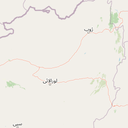
Map view of Ziarat National Park

Use this park location map to pinpoint Ziarat National Park in Pakistan, understand its exact geographic position, and read its mapped placement within the surrounding landscape more clearly.

Pigeon | © OpenStreetMap contributors

Location context for Ziarat National Park

Balochistan
Park atlas

Trace the regional geography of protected landscapes surrounding Balochistan's ancient juniper forests.

Explore Nearby National Parks and Protected Areas Beyond Ziarat National Park

Browse a curated selection of national parks and protected areas located near Ziarat National Park, mapping the spread of conservation landscapes across Pakistan. This geographic overview provides valuable context for comparing diverse protected zones within the mountainous terrain and dryland ecosystems of Balochistan and beyond.
Biosphere reserveBalochistan
Mapped park locations coincide#1 closest

Ziarat Juniper Forest Biosphere Reserve: Protected Mountain Landscapes of Balochistan

Ancient juniper woodlands and high mountain terrain in Pakistan.

Ziarat Juniper Forest represents one of the largest and most ecologically significant juniper woodlands in the world. Located in the Ziarat district of Balochistan, this biosphere reserve spans an extensive area of mountainous ridges and deep valleys. The forest is characterized by extreme longevity among its trees and provides a critical case study in dry temperate forest geography, conservation status, and climate tolerance within the broader context of Pakistani mountain landscapes.

Area
1,118.52 km²
Established
2013
IUCN
IV
Relief
Mountain
National parkBalochistan
About 108 km away#2 closest

West

Takatu National Park: Balochistan's Mountainous National Park and Protected Landscape

Explore the park's mapped terrain and Sulaiman markhor habitat.

Takatu National Park represents a significant protected landscape in the highlands of Balochistan, Pakistan. Established in 2025, this national park features the dramatic mountainous terrain dominated by Koh-i-Takatu, the region's third-highest peak. The park's boundaries encompass critical habitat for the endangered Sulaiman markhor, contributing to a vital conservation corridor. Its geography offers a distinctive semi-arid mountain character, distinct from other protected areas in Pakistan, making it a notable site for atlas-driven exploration and understanding of regional biodiversity.

Area
135.246 km²
Established
2025
IUCN
II
Relief
Mountain
National parkBalochistan
About 138 km away#3 closest

West

Hazarganji-Chiltan National Park: Balochistan's Mountain Protected Area & Landscape

Explore protected wildlife habitats and unique terrain in the Sulaiman Mountains.

Hazarganji-Chiltan National Park represents a significant protected landscape within Balochistan, Pakistan. Designated as a national park, it is fundamental to the conservation of the Chiltan ibex and Sulaiman Markhor, showcasing a unique arid mountain ecosystem. The park's terrain encompasses a transition from desert conditions to higher juniper forests, offering a detailed case study in regional geography and protected area management. Understanding Hazarganji-Chiltan National Park provides essential context for the mapped distribution of critical wildlife habitats in the Sulaiman Mountains range.

Area
155.55 km²
Established
1980
IUCN
II
Relief
Mountain
Protected areaIran
About 194 km away#4 closest

East

Koh-e-Sulaiman Protected Area: Sacred Mountain Geography and Landscape Context in Iran

Discover unique terrain and cultural heritage within this protected mountain range.

Koh-e-Sulaiman is a vital protected area within Iran, distinguished by the sacred Takht-e-Sulaiman peak, a site of deep spiritual importance. This landscape features rugged mountains, steep ridges, and deep valleys, contrasting sharply with surrounding plains. The protected area's unique geological complexity and dramatic terrain make it a significant natural and cultural landmark. MoriAtlas offers detailed geographic context to understand its protected boundaries and its role in the regional atlas, focusing on landscape discovery and natural features.

Area
6,475 km²
Relief
Mountain
Climate
Arid
Access
Remote access
Protected areaAfghanistan
About 238 km away#5 closest

North

Ab-i Istada Protected Area: Mapped Wetland Landscape in Afghanistan's Hindu Kush

Explore its unique alkaline geography and bird habitat.

Ab-i Istada is a crucial protected area featuring a large, shallow endorheic salt lake set within a geological depression in Afghanistan's Hindu Kush foothills. This protected landscape is globally recognized for its importance as a stopover for migratory birds. The site's dynamic water levels, alkaline conditions, and surrounding wetlands offer a unique focus for atlas-based geographic exploration and understanding the context of protected areas in Central Asia.

Area
130 km²
Established
1974
IUCN
IV
Relief
Highland
Wildlife reserveKhairpur District
About 307 km away#6 closest

South

Mehrano Wildlife Sanctuary: Protected Forest Landscapes and Geography in Khairpur District

A historic wildlife reserve along the Indus riverine corridor.

Mehrano Wildlife Sanctuary represents a unique intersection of private historical stewardship and modern conservation. This riverine forest in Khairpur District provides a critical habitat for large game and migratory bird populations, functioning as a lush ecological refuge at the edge of the Cholistan desert. The terrain offers a distinct study in Indus floodplain geography and long-standing protected land management.

Area
2.8 km²
Established
1790
Relief
Lowland
Scope
Terrestrial
Wildlife reserveSindh
About 311 km away#7 closest

South

Drigh Lake Wildlife Reserve: Protected Wetland Geography in Sindh, Pakistan

Mapped freshwater habitat in the Indus river basin

Drigh Lake is a designated wildlife sanctuary and Ramsar site in the Qambar Shahdadkot District of Sindh. This protected area features shallow, reed-fringed freshwater environments that serve as an essential waterbird haven. Analyze the park boundaries and the surrounding alluvial plains that characterize this significant regional wetland geography.

Area
1.64 km²
Established
1972
Scope
Terrestrial
Water
Water-dominated
Wildlife reservePunjab
About 313 km away#8 closest

Northeast

Chashma and Taunsa Barrage Dolphin Sanctuary: Protected Riverine Geography in Punjab

Freshwater habitat boundaries and Indus River landscape context

Chashma and Taunsa Barrage Dolphin Sanctuary serves as a key protected site for the Indus river dolphin, offering a unique look at riverine conservation in Punjab. This habitat, defined by its hydrology between two major barrages, acts as an essential wetland and wildlife corridor. The area provides a specialized landscape study for those tracing the ecological features of the Indus River system through this significant protected zone.

Established
1972
Water
Major water bodies

Common questions about visiting, size, designation, and location context for Ziarat National Park

Ziarat National Park FAQs for park facts, access, geography, and protected area context

Find quick answers about Ziarat National Park, including protected-area facts, park geography, trail and visitor context, and how the park fits into its surrounding country and regional landscape.
MoriAtlas Explorer

Continue Your Protected Areas Search Across the Global Atlas

Deepen your exploration by continuing the structured search for national parks and protected areas worldwide. Utilize the comprehensive filtering capabilities to compare different conservation landscapes and refine your understanding of global park geography. Discover more about the distribution and characteristics of protected natural areas.

Global natural geography
