
Mori Atlas logo
National parkZigalga National Park

Analyzing the ecological gradients, high mountain golets, and river basin boundaries of this Russian mountain refuge.

Zigalga National Park: A Comprehensive Geographical Exploration of Southern Ural Protected Landscapes

(National Park «Зигальга» (Zigalga))

Zigalga National Park encompasses a protected expanse of the Southern Ural Mountains within Chelyabinsk Oblast. This territory guards a significant elevational gradient that transitions from dense, dark coniferous taiga forests in the river valleys to exposed, alpine-like golets tundra on the high mountain summits. Through its river-cut ridges and expansive watersheds, the park provides essential habitat connectivity and preserves relict plant communities across the rugged Ural terrain.

Southern Uralsmountain parkdark coniferous foresttundra highlandsgolets zoneriver valleys

Zigalga National Park

National park

Park overview

Structured park overview, official facts, and landscape profile for Zigalga National Park

Zigalga National Park park facts, protected area profile, and essential visitor context

Review the core facts for Zigalga National Park, including designation, size, terrain, visitor scale, habitats, and operating context in one park-focused overview.

About Zigalga National Park

Zigalga National Park is a mountain protected area in the Southern Urals, positioned in the rugged interior of Chelyabinsk Oblast in Russia. The park encompasses an extensive tract of forested ridges, high-mountain tundra plateaus, river valleys, and headwater streams that collectively represent one of the most ecologically intact zones of the Southern Ural range.

The park was established on 18 November 2019 under Russia's national «Ecology» project, a federal initiative aimed at expanding and strengthening the country's network of protected natural areas. The reserve lies within the Katav-Ivanovsky municipal district, an area historically shaped by the interplay of forest industries, mining heritage, and traditional land use. By bringing these landscapes under national park status, the designation shifts the long-term management focus firmly toward biodiversity conservation, watershed protection, scientific research, and regulated public access.

Ecologically, Zigalga belongs to the dark coniferous (taiga) belt and the upper golets tundra zone, with elevation zones transitioning from dense spruce and fir forests to open, lichen-covered summits and windswept slopes. The park's river systems, anchored by the Yuryuzan and Kutkurka, along with more than forty named streams and a number of small bogs, give the area a strong hydrological character and create habitat variety across a relatively compact area.

The park's biodiversity profile is one of its defining strengths: roughly five hundred vascular plant species have been recorded, several of which are protected at the federal or regional level, and its fauna spans a broad mix of mammals, birds, amphibians, reptiles, and fish. This combination of elevational zonation, intact forest cover, and meaningful species richness makes Zigalga an important node in the Southern Ural protected-area network and a significant area for taiga and subalpine conservation in Russia.

Quick facts and research context for Zigalga National Park

Zigalga National Park lies in the Katav-Ivanovsky district of Chelyabinsk Oblast in Russia, in the central-southern portion of the Ural Mountains. The reserve sits in the headwater basins of the Yuryuzan and Kutkurka rivers and encompasses both forested slopes and high-mountain tundra across the Southern Ural ridge system. It was formally established on 18 November 2019 as part of Russia's federal «Ecology» national project and is managed as an IUCN Category II national park, placing it among the country's newer and more ecologically focused protected mountain territories.

Protection and recognition

Examine documented terrestrial protection records and international recognition data for Zigalga National Park.

Zigalga National Park Protection Status and Mapped Conservation Scope

Zigalga National Park maintains a documented terrestrial protection status with structured records outlining its management scope and conservation boundaries. Conservation researchers review these verified protection frameworks to analyze administrative designations and international recognition data.

Protection details

Protection scope
Terrestrial
Transboundary protection
No
Park context

Deeper park guide and search-rich context for Zigalga National Park

Zigalga National Park history, landscape, wildlife, and travel context

Explore Zigalga National Park through its history, landscape character, ecosystems, wildlife, conservation priorities, cultural context, and seasonal travel timing in a structured park guide built for atlas discovery and search intent.

Why Zigalga National Park stands out

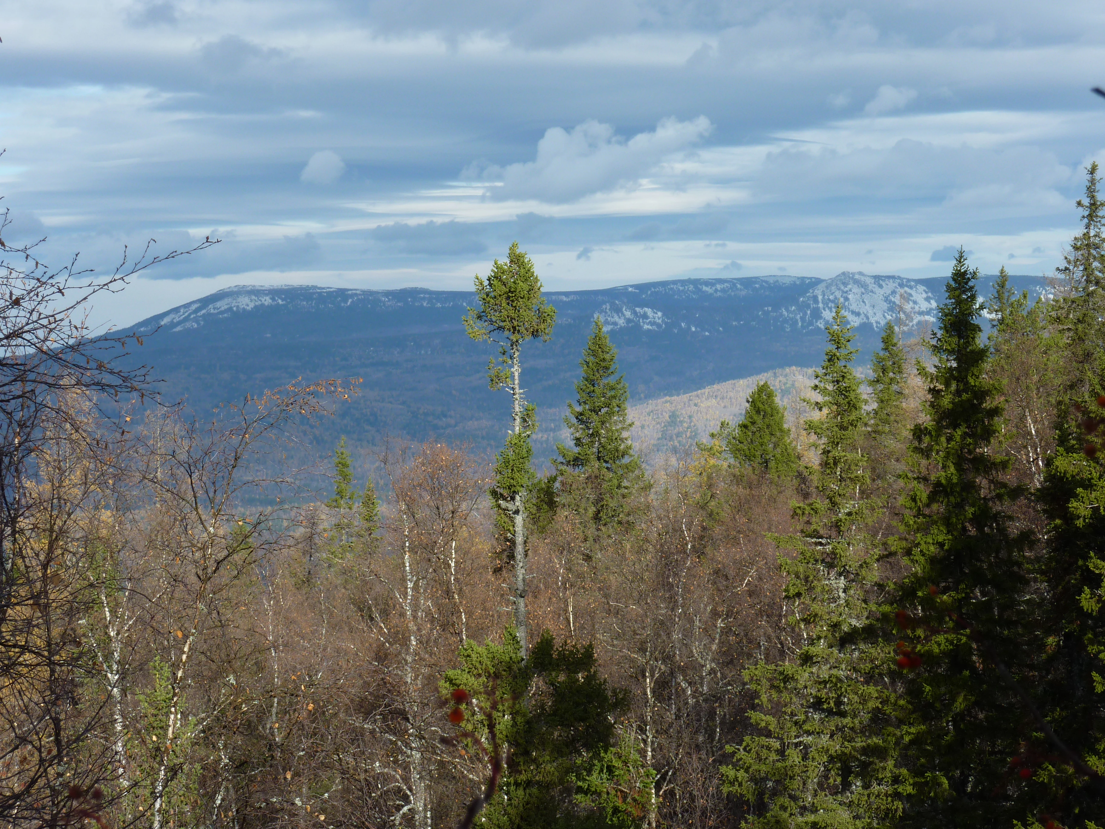
Zigalga is best known for its high-elevation dark coniferous forests and golets (mountain tundra) landscapes, which together form one of the distinctive ecological gradients of the Southern Urals. The park protects stretches of the Yuryuzan river basin and the adjacent Kutkurka watershed, both of which are important for regional hydrology and biodiversity. The area is also notable for its concentration of protected and rare species, including vascular plants listed in regional Red Data Books and mammals and birds tied to mature taiga and subalpine habitats. Its relatively recent designation as a national park reflects Russia's broader effort to strengthen protection of intact Ural mountain ecosystems.
Zigalga National Park history and protected-area timeline

Zigalga National Park was formally established on 18 November 2019 as a federal protected area under Russia's national «Ecology» project. Its creation reflects a national-level effort in the late 2010s to expand, modernize, and strengthen the country's system of nature reserves, particularly in mountain regions that had previously been partially affected by logging, mining, and other resource-based activities.

The decision to designate the area as a national park recognizes the ecological importance of the Yuryuzan and Kutkurka river basins and the surrounding mountain massifs of the Southern Urals. By placing the territory under IUCN Category II management status, the park was placed within a framework that prioritizes ecosystem conservation, scientific monitoring, environmental education, and carefully managed recreation. As a relatively young national park, Zigalga's institutional history is still developing, and much of its longer-term conservation story will unfold in the decades following its founding.

Zigalga National Park landscape and geographic character

The landscape of Zigalga National Park is defined by the rugged, forested ridges and high-mountain plateaus of the Southern Ural range. The territory spans an elevational gradient that begins in deeply forested valleys and climbs toward open, exposed summits where trees give way to tundra-like vegetation. This combination of steep slopes, ridge crests, river-cut valleys, and rounded mountaintops gives the park a varied and visually dramatic relief.

The Yuryuzan and Kutkurka rivers shape the park's drainage geography, while more than forty smaller streams crisscross the lower and middle elevations, fed by snowmelt and rainfall from the surrounding slopes. Swampy pockets and small bogs occupy flatter sections, particularly where drainage is slowed in the upper valleys. Together these features create a mosaic of habitats that range from dense shaded forest to windswept alpine-like terrain.

Zigalga National Park ecosystems, habitats, and plant life

Ecologically, Zigalga occupies one of the characteristic Southern Ural vegetation zones: the dark coniferous taiga belt transitioning into upper mountain tundra, or golets, at the highest elevations. The forests of the lower and middle slopes are dominated by shade-tolerant conifers and a dense understory typical of old-growth Urals taiga, while the upper elevations open into moss, lichen, and dwarf shrub communities adapted to harsh, cold conditions.

The combination of intact forest cover, unfragmented river valleys, and elevational zonation supports a rich mix of plant communities across a relatively limited geographic area. The park's protected vascular flora includes roughly five hundred recorded species, among them rare and conservation-relevant plants such as arctic raspberry (Rubus arcticus), mezereon, Siberian clematis, and various locally protected alpine and subalpine taxa.

Zigalga National Park wildlife and species highlights

Zigalga supports a rich vertebrate fauna shaped by its mix of dark coniferous forests, mountain rivers, and subalpine zones. The recorded fauna includes fifty-five mammal species, 159 bird species, thirteen amphibian and reptile species, and seventeen fish species, reflecting the habitat variety across the park's elevation gradient.

Typical large mammals of mature Southern Ural taiga, including brown bear and Eurasian lynx, are part of the park's wildlife profile, alongside smaller carnivores, ungulates, and rodents associated with coniferous forest and rocky terrain. The river systems of the Yuryuzan and Kutkurka, along with numerous streams, contribute to aquatic habitat for native fish and to amphibian diversity in boggy and wet sections of the park. Several species recorded at Zigalga are listed in the Red Data Book of the Russian Federation, and many additional species are included in the Red Data Book of Chelyabinsk Oblast, underlining the conservation significance of the park's wildlife.

Zigalga National Park conservation status and protection priorities

Zigalga National Park plays an important role in the conservation of intact Southern Ural ecosystems, particularly the dark coniferous forest belt and the upper golets tundra, both of which are characteristic yet increasingly pressured habitats in the region. By placing the Yuryuzan and Kutkurka basins under national park protection, the reserve helps safeguard watershed integrity, large tracts of old-growth taiga, and a network of mountain streams and small wetlands that are ecologically and hydrologically significant.

The park's biodiversity profile, anchored by roughly five hundred vascular plant species and a diverse vertebrate fauna, gives it strong conservation value, especially given that thirteen species are listed in the Red Data Book of the Russian Federation and forty-eight are included in the Red Data Book of Chelyabinsk Oblast. Managed under the IUCN Category II national park framework, Zigalga contributes to Russia's national strategy of expanding and strengthening the protected-area network in ecologically sensitive mountain regions.

Zigalga National Park cultural meaning and human context

Zigalga lies in the Katav-Ivanovsky district of Chelyabinsk Oblast, a part of the Southern Urals with a layered human history shaped by indigenous Bashkir and other Ural-region communities, later Russian settlement, and a long tradition of mining and forestry. The Ural Mountains have long functioned as a boundary landscape between Europe and Asia, and mountain communities in this region have historically combined mountain taiga resource use with seasonal land use and local craft traditions.

As a recently designated national park, Zigalga's contemporary cultural role is increasingly tied to environmental education, regional tourism, and the protection of traditional natural landscapes of the Southern Urals. While the park itself is a federal nature reserve at its core, its broader cultural context continues to be shaped by the surrounding communities of the Katav-Ivanovsky district and the wider Chelyabinsk region.

Top sights and standout views in Zigalga National Park

Zigalga's standout qualities include its transition from dense dark coniferous taiga to high-mountain golets tundra within a single contiguous protected area. The headwater landscapes of the Yuryuzan and Kutkurka rivers give the park strong hydrological and ecological significance, while more than forty streams and scattered bogs add fine-scale habitat variety.

The park's biological richness is another defining highlight: with around five hundred vascular plant species and a vertebrate fauna that includes 159 bird species and 55 mammal species, Zigalga is a key contributor to Southern Ural biodiversity conservation. Its status as one of Russia's newer national parks, established in 2019 under the federal «Ecology» project, also makes it an example of the country's renewed investment in mountain protected-area expansion.

Best time to visit Zigalga National Park

For visitors interested in experiencing the contrasting landscapes of Zigalga, late spring through early autumn is generally when the park's terrain is most accessible and visually expressive. In summer, the dark coniferous forests along the rivers are at their densest, the boggy sections become more biologically active, and the higher golets zones are free of snow, offering open views across the Southern Ural ridges.

Late summer and early autumn can also be a rewarding time, when upper-elevation vegetation begins to show seasonal color shifts against the dark forest backdrop and wildlife is active across the elevation gradient. Winter conditions, while harsh, transform the park into a snow-covered taiga and tundra landscape, though access and travel within the park become substantially more demanding and typically require established winter infrastructure or guided routes.
Monthly climate preview

Long term temperature and precipitation records across representative coordinate data

Zigalga National Park Climate Normals and Annual Weather Patterns

Representative baseline coordinates record monthly temperature variations alongside recorded precipitation averages at a 668 meter elevation. Detailed twelve month climate profiles provide comprehensive historical data for analyzing annual environmental rhythms.
Annual mean1 °C
-15 °C17 °C
Jan-15°
Feb-14°
Mar-8°
Apr
May10°
Jun15°
Jul17°
Aug15°
Sep
Oct
Nov-8°
Dec-14°
Warmest month
July

16.9 °C

Coolest month
January

-15.2 °C

Wettest month
July

2.7 mm/day

Driest month
January

0.7 mm/day

Park location guide

Geography guide, regional context, and park location map for Zigalga National Park

Zigalga National Park park geography, regions, and map view in Russia

Understand where Zigalga National Park sits in Russia through a broader geographic reading of the surrounding landscape, nearby location context, and its mapped position within the national park landscape.

How Zigalga National Park fits into Russia

Russia is a transcontinental nation spanning eleven time zones, bordered by fourteen countries. It is the world's largest country by area, covering 17,098,246 km². Moscow is the capital and largest city, while Saint Petersburg is the second-largest and a major cultural centre.

Wider geography shaping Zigalga National Park in Russia

Russia spans Eastern Europe and North Asia, covering 17,098,246 km². It shares land borders with fourteen countries, more than any other nation, and spans eleven time zones. The landscape includes vast plains, mountain ranges such as the Urals and Caucasus, and extensive coastlines along the Arctic Ocean, Pacific Ocean, Baltic Sea, Black Sea, and Caspian Sea.

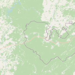
Map view of Zigalga National Park

Use this park location map to pinpoint Zigalga National Park in Russia, understand its exact geographic position, and read its mapped placement within the surrounding landscape more clearly.

Pigeon | © OpenStreetMap contributors

Location context for Zigalga National Park

Chelyabinsk Oblast
Park atlas

Compare regional mountain geography and connected protected areas across the Southern Urals

Explore Other Parks Near Zigalga National Park and Related Protected Landscapes

Browse nearby national parks and protected areas sharing similar rugged terrain, dark coniferous taiga, and high alpine tundra zones. Comparing adjacent mountain reserves provides a wider geographic perspective on regional conservation landscapes and river basin ecosystems.
Watercolor illustration of a mountain range with purple peaks, green hills, a single tall pine tree, and pinkish foreground vegetation
National parkChelyabinsk Oblast
About 5.7 km away#1 closest

West

Zigalga National Park: Geography, Alpine Terrain, and Protected Wilderness Areas

A vital ecological corridor within the Chelyabinsk Oblast of Russia

Zigalga National Park serves as a pristine natural sanctuary at the crossroads of Europe and Siberia. The territory features steep mountainous ridges, expansive peat bogs, and vertical floral zonation that defines the Southern Ural landscape. This protected area provides a stable environment for rare boreal plant species and remains largely untouched by development, offering a valuable record of subarctic ecosystem health.

Area
457 km²
Established
2019
IUCN
II
Relief
Mountain
National parkChelyabinsk Oblast
About 34 km away#2 closest

Northeast

Zyuratkul National Park: Mapped Geography and Protected Landscapes of the Southern Urals

High-mountain lake terrain and diverse taiga forest ecosystems.

Zyuratkul National Park serves as a critical protected area in the Chelyabinsk Oblast, showcasing the meeting of Siberian and European ecosystems. The territory features a dramatic range of landforms including the high-mountain Lake Zyuratkul, alpine tundra on Nurgush ridge, and deep valleys containing ancient archaeological sites. This atlas entry provides a foundational view of the park's natural terrain, geographic features, and protected boundary structure.

Area
882.49 km²
Established
1993
IUCN
II
Relief
Mountain
Watercolor illustration depicting rolling hills, green forests, and distant mountains under a pale sky
National parkChelyabinsk Oblast
About 35 km away#3 closest

Northeast

Zyuratkul National Park: Geography, Alpine Lakes, and Mountain Range Maps

Protected mountain wilderness in Chelyabinsk Oblast, Russia

Analyze the protected geography of Zyuratkul National Park, home to the highest point in Chelyabinsk Oblast and a distinctive alpine lake basin. Explore the park boundaries and the vertical transition from dense forest to the craggy summits of the Nurgush and Zyuratkul mountain ranges.

Area
882.49 km²
Established
1993
IUCN
II
Relief
Mountain
Watercolor illustration of rolling hills, green forests, and distant mountains under a pale sky
National parkRussia
About 107 km away#4 closest

Northeast

Taganay National Park: Protected Landscape and Regional Geography Explorer

Explore mapped protected areas and natural landscapes.

Taganay National Park stands as a key protected area within Russia, offering unique geographic features and a distinct regional landscape identity. This entry serves as a gateway to understanding the park's role as a national park, providing context for its mapped boundaries and environmental setting. Utilize this resource for structured discovery of protected lands and their place within the broader atlas of natural geographies.

IUCN
II
Scope
Terrestrial
National parkBashkortostan
About 220 km away#5 closest

Southwest

Bashkiriya National Park: Protected Karst Landscapes and Ural Mountain Geography

Southern Ural forest ecosystems and karst cave networks

Bashkiriya National Park protects over 900 square kilometers of mountainous terrain and river valleys in the Republic of Bashkortostan. The park serves as a prime example of the Southern Ural transition, featuring an intricate mix of karst sinkholes, surface streams, and mature broadleaf forests that support diverse temperate wildlife and avian communities.

Area
920 km²
Established
1986
IUCN
II
Visitors
30K annual
Watercolor painting showing a scenic landscape with mountains, a river, and trees
National parkBashkortostan
About 220 km away#6 closest

Southwest

Bashkiriya National Park: Mapping Karst Landscapes and Ural Forest Geography

Exploring protected terrain in the Bashkortostan region

Bashkiriya National Park anchors a critical conservation area along the southern Ural Mountains, characterized by its deep canyons, limestone grottoes, and vast subterranean cave networks. The park serves as a bridge for biodiversity at the continental edge, where river-carved valleys and dense taiga forests create a distinct, protected landscape for regional research and geographic study.

Area
920 km²
Established
1986
IUCN
II
Relief
Mixed relief
Wildlife reserveKostanay Region
About 235 km away#7 closest

Southeast

Mikhaylovsky Zakaznik: Geographic Overview of the Kostanay Region Wildlife Reserve

A protected forest steppe sanctuary in northern Kazakhstan.

Mikhaylovsky Zakaznik acts as an enduring zoological refuge within the Kostanay Region, protecting a rich tapestry of woodland and meadow steppe environments. This reserve supports native ungulates and game birds by maintaining a stable, low-profile landscape of birch and pine groves that function as critical corridors for biodiversity across the borderlands.

Area
768 km²
Established
1967
Relief
Upland
Access
Access unknown
National parkUdmurtia
About 374 km away#8 closest

Northwest

Nechkinsky National Park: Protected Kama River Valley Geography and Landscape Atlas

Kama River valley protected areas and floodplain topography

Spanning the middle course of the Kama River and the Votkinsk Reservoir, Nechkinsky National Park protects a diverse mosaic of forest, wetland, and riverine habitats. The terrain features a sharp contrast between elevated forest slopes and flat alluvial floodplains, serving as a primary conservation landscape for the regional biodiversity of Udmurtia.

Area
207.52 km²
Established
1997
IUCN
II
Relief
Upland

Common questions about visiting, size, designation, and location context for Zigalga National Park

Zigalga National Park FAQs for park facts, access, geography, and protected area context

Find quick answers about Zigalga National Park, including protected-area facts, park geography, trail and visitor context, and how the park fits into its surrounding country and regional landscape.
MoriAtlas Explorer

Continue Your Protected Areas Search Across the Global Atlas

Deepen your exploration by continuing the structured search for national parks and protected areas worldwide. Utilize the comprehensive filtering capabilities to compare different conservation landscapes and refine your understanding of global park geography. Discover more about the distribution and characteristics of protected natural areas.

Global natural geography