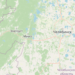
Explore the mapped boundaries and regional setting of Taganay National Park's protected lands.
Taganay National Park represents a significant protected natural area within the Russian Federation, offering a distinct geographic profile for atlas-based exploration. This page provides a foundational understanding of Taganay National Park as a designated national park, highlighting its place within the broader mapped landscape and regional geography. Users can begin to understand the protected area's context, facilitating deeper dives into its mapped terrain and protected land identity.
Taganay National Park
National park
Structured park overview, official facts, and landscape profile for Taganay National Park
Geography guide, regional context, and park location map for Taganay National Park
Russia is a transcontinental nation spanning eleven time zones, bordered by fourteen countries. It is the world's largest country by area, covering 17,098,246 km². Moscow is the capital and largest city, while Saint Petersburg is the second-largest and a major cultural centre.
Russia spans Eastern Europe and North Asia, covering 17,098,246 km². It shares land borders with fourteen countries, more than any other nation, and spans eleven time zones. The landscape includes vast plains, mountain ranges such as the Urals and Caucasus, and extensive coastlines along the Arctic Ocean, Pacific Ocean, Baltic Sea, Black Sea, and Caspian Sea.
Common questions about visiting, size, designation, and location context for Taganay National Park
Deepen your exploration by continuing the structured search for national parks and protected areas worldwide. Utilize the comprehensive filtering capabilities to compare different conservation landscapes and refine your understanding of global park geography. Discover more about the distribution and characteristics of protected natural areas.