
Ponds
Park geography
Analyzing the physical terrain, boundary span, and key natural landmarks of the region.
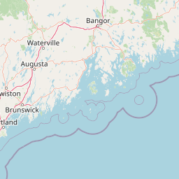
Comprehensive Geographic Profile and Mapped Boundaries of Acadia National Park in Maine
Access a detailed geographic breakdown of Acadia National Park, spanning 198.6 square kilometers across the coastal region of Maine. This profile maps the protected landscape, including elevation peaks like Cadillac Mountain and unique coastal cliffs, offering a clear view of the park's physical extent, regional coordinates, and terrain characteristics.
Related tags
Coastal LandscapeMountain PeaksBoreal ForestGlacial GeologyHistoric Carriage Roads
New England's premier coastal national park and the first national park east of the Mississippi River
Acadia National Park
Acadia National Park is a coastal national park spanning the mid-section of the Maine coast, centered on Mount Desert Island with additional holdings on the Schoodic Peninsula, Isle au Haut, and numerous smaller islands. The park protects a remarkable diversity of landscapes including granite mountains rising from the Atlantic Ocean, deep glacial valleys, pristine lakes and ponds, spruce-fir forests, and over 57 miles of rugged coastline. Established as Sieur de Monts National Monument in 1916 and later renamed Lafayette National Park before becoming Acadia in 1929, it holds the distinction of being the first national park created from private lands gifted to the public and the only national park in the Northeastern United States. The park encompasses approximately 49,000 acres and receives over four million visitors annually, drawn by its distinctive combination of coastal scenery, mountain vistas, and extensive carriage road network.
- Location
- United States of America
- Park type
- National park
- Established
- 1919
- Area
- 198.6 km²
- Highest point
- 470 m
Location overview
Mapping the administrative region and country boundaries of the park
Geographic Location and Regional Setting of Acadia National Park
Acadia National Park is located within the state of Maine in the United States of America. National and regional registries define the official administrative boundaries of the conservation area.
- Countries
- United States of America
- Regions
- Maine
- Primary location
- Maine
Boundary and coordinates
Analyzing the 198.6 square kilometer span and spatial coordinates
Acadia National Park Geographic Boundary Map and Limits
The mapped outline of the park provides essential spatial context for its coastal and island layout. Integrated geographic facts detail the calculated area, coordinates, center points, and directional spans of the protected territory.
- Boundary area
- 153 km²
- Boundary perimeter
- 339.6 km
- Northernmost point
- 44.4299° N
- Southernmost point
- 44.003° N
- Easternmost point
- 68.0299° W
- Westernmost point
- 68.661° W
- Geographic centre
- 44.3104° N, 68.2914° W
- North–south span
- 47.4 km
- East–west span
- 50.4 km
Elevation and terrain
Mapped physical features and vertical range details
Acadia National Park Terrain and Elevation Statistics
Recorded elevation metrics establish a peak altitude of four hundred seventy meters across the protected landscape. Individual feature cards list named summits, streams, and coastal formations with verified spatial relationships.
- Highest point
- 470 m
Selected named natural features
Peaks
Huguenot Head
222 m
Streams
Canon Brook
Bays
Gulf of Maine
0 m
Cliffs
Cadillac Cliffs
85 m
Streams
Hunters Brook
Environmental setting
Temperate climate zones and major water presence profiles
Acadia National Park Environmental Classifications and Physical Setting
Recorded environmental classifications organize physical setting attributes into structured interpretive categories for analytical comparison. Associated atlas destinations link these baseline climate and water presence records to broader regional geography contexts.
- Climate
- Temperate
- Water
- Major water bodies
Park atlas
Explore the geographic context of adjacent protected landscapes and national parks near Acadia.
Explore Nearby Protected Areas and National Parks Beyond Acadia National Park
Continue your discovery from Acadia National Park by browsing a curated list of nearby national parks and regional protected areas, understanding their unique coastal, mountain, and boreal forest landscapes. Compare their geographic distribution and conservation profiles to place Acadia's distinctive terrain within a broader protected-area context across the Northeast.
Protected landscapeNew Hampshire
172 km away#1 closest
West

White Mountain National Forest: Protected Landscape Atlas and Geographic Boundary Context
Mapping the alpine ridges and river valleys of New Hampshire
Delve into the geography of White Mountain National Forest, a primary federal protected landscape in the eastern United States. This overview details the mountainous terrain, including the Presidential Range and Pemigewasset Wilderness, providing a clear window into its spatial scale, watershed boundaries, and regional prominence within the New England landscape.
- Area
- 3,038.59 km²
- Established
- 1918
- Relief
- Mountain
- Climate
- Temperate
National parkNova Scotia
206 km away#2 closest
East

Kejimkujik National Park: Detailed Protected Landscape and Regional Geography
Explore mapped boundaries and geographic context in Nova Scotia.
Kejimkujik National Park offers a dedicated entry for understanding protected natural areas. As a national park in Nova Scotia, its geographic features and protected boundaries are detailed here to support atlas-based exploration. Discover the park's unique landscape context and its positioning within regional geography, providing a factual basis for comprehending its role as a conservation area.
- Area
- 404 km²
- Established
- 1967
- IUCN
- II
- Visitors
- 75.3K annual
Nature reserveNew Hampshire
About 210 km away#3 closest
Southwest
Great Bay National Estuarine Research Reserve: Protected Coastal and Estuarine Geography
Regional tidal habitat and protected watershed in New Hampshire
Great Bay National Estuarine Research Reserve protects a vital coastal landscape characterized by broad tidal basins, fringing salt marshes, and inland woodlands. Located in southeastern New Hampshire, this nature reserve serves as an essential site for studying the intersection of freshwater and saltwater ecosystems, preserving a mosaic of land and water that illustrates the complex geography of the Atlantic coast.
- Area
- 41.42 km²
- Established
- 1989
- Relief
- Lowland
- Climate
- Temperate
Wildlife reserveNew Brunswick
About 216 km away#4 closest
Northeast
Portobello Creek National Wildlife Area: Protected Wetland Geography and Regional Atlas
Saint John River floodplain reserve in New Brunswick
Portobello Creek National Wildlife Area protects an expansive wetland complex characterized by riverine marshes, shrub thickets, and low-lying floodplain forests. As a key site within the Saint John River system, the reserve offers unique insight into the geomorphic and ecological character of Atlantic Canadian wetlands.
- Area
- 21.54 km²
- Established
- 1995
- IUCN
- Ia
- Relief
- Lowland
Wildlife reserveNova Scotia
246 km away#5 closest
East
Zugvogelschutzgebiet Sable River Wildlife Reserve and Nova Scotia Coastal Geography
Protected estuarine sanctuary and waterfowl habitat
Spanning the sheltered waters of a river estuary, Zugvogelschutzgebiet Sable River acts as a essential component of the coastal conservation landscape in Nova Scotia. This protected wildlife reserve remains a vital staging area for migratory species, defined by its tidal salt marshes and open aquatic terrain which function in coordination with neighboring Atlantic sanctuary sites.
- Area
- 3.13 km²
- Established
- 1941
- IUCN
- Ia
Wildlife reserveNova Scotia
249 km away#6 closest
East
Haley Lake Migratory Bird Sanctuary: Protected Wildlife Reserve in Nova Scotia
Freshwater avian sanctuary and coastal nesting habitat
Haley Lake Migratory Bird Sanctuary provides a crucial freshwater refuge on the southwestern coast of Nova Scotia. This wildlife reserve features a unique lakeside environment that supports large gatherings of migratory waterfowl and a historic great blue heron breeding colony, situated between the brackish tidal flats of the surrounding estuarine landscape.
- Area
- 0.95 km²
- Established
- 1980
- IUCN
- Ia
- Relief
- Lowland
Wildlife reserveNova Scotia
250 km away#7 closest
East
Zugvogelschutzgebiet Port Hebert: Coastal Protected Landscapes of Nova Scotia
Wildlife reserve and intertidal wetland geography
Spanning the shallow reaches of Port L'Hebert, this wildlife reserve serves as a foundational element of the South Shore protected area network. The sanctuary is defined by its wide tidal range, which uncovers extensive sand and mudflats to provide essential feeding grounds for migratory geese and ducks. This site offers deep insight into the coastal geography and wetland preservation status of Nova Scotia's rugged Atlantic fringe.
- Area
- 3.46 km²
- Established
- 1941
- IUCN
- Ia
Wildlife reserveNova Scotia
About 259 km away#8 closest
Northeast
Île Haute Wildlife Reserve: Mapped Volcanic Geography and Coastal Protected Terrain
Bay of Fundy protected area, Nova Scotia
Rising abruptly from the Bay of Fundy, Île Haute features a steep, isolated plateau encircled by 100-meter basalt cliffs. This wildlife reserve showcases Jurassic volcanic geology and provides essential habitat for migratory seabirds and marine mammals. Gain insights into the island's unique coastal geography and its role as a protected natural sanctuary in Atlantic Canada.
- Area
- 0.8 km²
- Established
- 2025
- Relief
- Upland
- Scope
- Mixed
MoriAtlas Explorer
Continue Exploring Acadia National Park's Geographic and Landscape Context
Further investigate Acadia National Park to deepen your understanding of its protected status and its position within Maine's geography. Access detailed mapping and regional context to appreciate the park's landscape identity and its significance in the atlas of protected areas. This exploration aids in grasping the spatial relationships of natural landscapes and conservation efforts.
Browse next
Global natural geography
Explore related park routes
Explore MoriAtlas Global ParksBrowse All MoriAtlas ParksGlobal Park Map DiscoveryMoriAtlas: Browse All CountriesBrowse All MoriAtlas ContinentsNational Park Environment AtlasGrand Canyon National Park AtlasYellowstone National Park AtlasYosemite National Park Atlas and GeographySerengeti National Park AtlasGalápagos National Park Protected LandscapeBanff National Park Geography and AtlasKruger National Park Atlas EntryUluṟu-Kata Tjuṯa National Park AtlasExplore Uluru-Kata Tjuta National Park GeographyPlitvice Lakes National Park AtlasFiordland National Park Protected LandscapeGreat Smoky Mountains National Park AtlasAfghanistan National Parks and Protected AreasAlbania National Parks and Protected AreasAlgeria National Parks and Protected AreasAmerican Samoa National Parks and Protected AreasAndorra National Parks and Protected AreasAngola National Parks and Protected AreasAntarctica National Parks and Protected AreasAntigua and Barbuda Park List