
Mori Atlas logo
Nature reserveAcantilados de Maro-Cerro Gordo

Mapping the dramatic intersection of Betic mountain terrain and Mediterranean shorelines

Acantilados de Maro-Cerro Gordo Nature Reserve: A Detailed Atlas of Andalusian Coastal Landscapes

(Paraje Natural de los Acantilados de Maro-Cerro Gordo)

Acantilados de Maro-Cerro Gordo represents a significant protected corridor where the rugged foothills of the Sierras de Tejeda, Almijara y Alhama drop directly into the Mediterranean Sea. This nature reserve, spanning the provinces of Granada and Málaga in Andalusia, preserves an intricate sequence of high cliffs, sheltered sandy coves, and essential marine seagrass habitats. The terrain serves as a vital transition zone, anchoring diverse Mediterranean plant communities and specialized fauna along a steep, indented coastal frontier.

coastal cliffsMediterranean coastprotected covesAndalusiamarine protected areaMediterranean vegetation
A minimalist, flat-style digital illustration showing rocky coastal cliffs meeting the sea, with green slopes, sandy coves, and distant hills.

Acantilados de Maro-Cerro Gordo

Nature reserve

Park overview

Structured park overview, official facts, and landscape profile for Acantilados de Maro-Cerro Gordo

Acantilados de Maro-Cerro Gordo park facts, protected area profile, and essential visitor context

Review the core facts for Acantilados de Maro-Cerro Gordo, including designation, size, terrain, visitor scale, habitats, and operating context in one park-focused overview.

About Acantilados de Maro-Cerro Gordo

Acantilados de Maro-Cerro Gordo is a coastal protected natural site (paraje natural) on the Mediterranean coast of southern Spain, occupying the borderlands between the provinces of Granada and Málaga in Andalusia. The protected area extends along the shoreline that runs between the town of Almuñécar to the east and Nerja to the west, taking in a stretch of coast where the Betic mountain ranges meet the sea.

Geologically, the area is an extension of the Sierras de Tejeda, Almijara y Alhama, with coastal spurs of these mountains dropping steeply into the Mediterranean. Wave erosion has carved a series of headlands and embayments along this collision between mountain and sea, producing a sharply alternating pattern of cliffs and small coves. Elevation differences along the cliffs reach several hundred meters above sea level in places, giving the site some of the most striking vertical coastal relief in this part of the Andalusian coast. Notable landmark headlands separating the main coves include Torre del Pino, Peñón del Fraile, Cerro de la Caleta, and Cerro Gordo.

Ecologically, the site preserves a representative slice of the Mediterranean coastal environment. Terrestrial habitats support pine woodlands, Mediterranean shrublands, and a coastal plant community adapted to salt exposure and sandy substrates. The marine environment, recognized through its ZEPIM designation, maintains underwater meadows of Posidonia oceanica and related seagrasses that anchor the ecological value of the nearshore waters. The combination of high cliffs, isolated coves, marine meadows, and steep mountain backdrop makes the protected area distinctive as a Mediterranean landscape where land and sea ecosystems meet in a compact coastal corridor.

The protected area also contains cultural-historical layers that complement its natural value, including 16th-century watchtowers built along the coast and a 19th-century aqueduct in the surrounding area. The nearby Cueva de Nerja, while outside the official boundaries of the natural site, belongs to the same geological complex and reinforces the regional importance of this stretch of coastline.

Quick facts and research context for Acantilados de Maro-Cerro Gordo

Acantilados de Maro-Cerro Gordo is a desde natural (protected natural site) on the Mediterranean coast of Andalusia, located between Almuñécar (Granada province) and Nerja (Málaga province). It covers a roughly 1,900-hectare stretch of coastline dominated by cliffs, rocky spurs, and small coves, formed by the seaward extensions of the Sierras de Tejeda, Almijara y Alhama. Declared in 1989, the area is also designated as a ZEPIM marine protection zone, highlighting its significance for Mediterranean coastal and marine ecosystems. Stands of Mediterranean pine, mastic shrubs, palmettos, and aromatic plants share the landscape with sandy-beach specialist plants and underwater meadows of Posidonia and related seagrass species.

Protection and recognition

Examine the documented protection scope and international recognition sources for Acantilados de Maro-Cerro Gordo.

Acantilados de Maro-Cerro Gordo Protection Status and Natura 2000 Recognition

Acantilados de Maro-Cerro Gordo holds a mixed protection scope supported by official Natura 2000 designation records. Review the documented conservation framework and recognition sources associated with this protected coastal landscape.
Park context

Deeper park guide and search-rich context for Acantilados de Maro-Cerro Gordo

Acantilados de Maro-Cerro Gordo history, landscape, wildlife, and travel context

Explore Acantilados de Maro-Cerro Gordo through its history, landscape character, ecosystems, wildlife, conservation priorities, cultural context, and seasonal travel timing in a structured park guide built for atlas discovery and search intent.

Why Acantilados de Maro-Cerro Gordo stands out

Acantilados de Maro-Cerro Gordo is best known for its dramatic high cliffs that drop directly into the Mediterranean, alternating with small isolated coves tucked between rocky spurs. The area is recognized for combining terrestrial Mediterranean vegetation with a rich marine environment, including seagrass meadows, rocky reef species, and seasonal use by cliff-nesting birds and reptiles of African origin. The juxtaposition of mountain scenery falling into the sea is a defining trait, illustrated by landmarks such as the Torre del Pino escarpment, Peñón del Fraile, Cerro de la Caleta, and the Cerro Gordo headland.
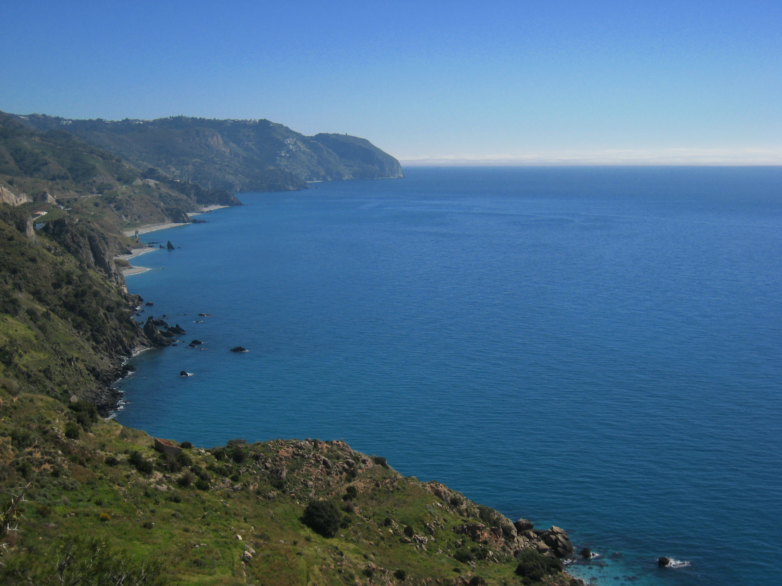
A wide-angle, high-angle view of steep, green-sloped cliffs dropping into the deep blue Mediterranean Sea along a sunny coastline.
Dramatic coastal cliffs overlooking the Mediterranean Sea at Acantilados de Maro-Cerro Gordo.

Acantilados de Maro-Cerro Gordo history and protected-area timeline

The Acantilados de Maro-Cerro Gordo area was formally declared a Paraje Natural in 1989, establishing a framework of protection for a coastal strip that had long been valued locally for its scenery and ecological richness. The declaration recognized both the terrestrial character of the cliffs and the ecological importance of the adjacent marine environment.

Beyond formal protection, the coast carries a longer human history embedded in its watchtowers. Several 16th-century coastal watchtowers, including the towers at Cerro Gordo, Cerro de la Caleta, and Torre del Pino, were built along this stretch as part of the historic defensive system of the Andalusian Mediterranean coast. A 19th-century aqueduct in the vicinity adds a later layer of cultural landscape to the surrounding area. While the natural site itself protects current ecological values, these standing structures reflect the historical importance of this coastline for surveillance, maritime activity, and local water infrastructure. The nearby Cueva de Nerja, one of the most important cave systems in southern Spain, lies in the same underlying geology and is associated with both prehistoric and modern cultural interest in the region.

Acantilados de Maro-Cerro Gordo landscape and geographic character

The landscape of Acantilados de Maro-Cerro Gordo is defined by the abrupt encounter between the southern slopes of the Betic mountains and the Mediterranean Sea. Coastal spurs of the Sierras de Tejeda, Almijara y Alhama fall toward the sea in a series of cliffs that, in places, exceed 200 meters in elevation difference. Wave action along this rocky shore has cut the cliffs into an irregular sequence of headlands and coves, producing a coastline that alternates between vertical rock faces and small, sheltered sandy beaches.

The most prominent headlands along the protected coast are Cerro Gordo, Cerro de la Caleta, Peñón del Fraile, and Torre del Pino. Between these rocky protrusions lie the well-known coves of Las Alberquillas and Cala del Cañuelo on the Málaga side, and Cantarriján on the Granada side. The combination of deep cliff faces with small, hard-to-access beaches gives the area a famously rugged character, where mountain scenery appears to descend directly into the sea with little transition. The terrain immediately inland rises toward the higher ridges of the Almijara range, connecting the protected coastal strip to wider protected natural landscapes just behind the shore.

Acantilados de Maro-Cerro Gordo ecosystems, habitats, and plant life

Ecologically, Acantilados de Maro-Cerro Gordo harbors a tightly compressed mix of terrestrial Mediterranean habitats and nearshore marine ecosystems. The terrestrial vegetation reflects classic Mediterranean plant succession, with stone pines (Pinus pinea) dominating woody cover on deeper soils, while shrubby layers include mastic shrubs (Pistacia lentiscus), European fan palms (Chamaerops humilis), myrtle, maritime rosemary, thyme, lavender, alucemas, and albaida. Cliffs and rocky outcrops host specialized plants such as maritime fennel, yellow Pallenis, matagallos, and lavanda species, while sandy beaches such as Alberquillas support psammophilous vegetation including the saltbush Barrilla espinosa and sea rocket (oruga de mar), both showing the thick, water-conserving stems typical of plants adapted to saline, sun-exposed substrates.

The marine component is equally distinctive. The coves and subtidal zones contain three of the four species of marine phanerogams (seagrasses) recorded along the Andalusian coast, including Posidonia oceanica meadows, Cymodocea nodosa, and Zostera marina. Rocky underwater surfaces host the orange starlet coral (Astroides calycularis), a striking octocoral-like species that inhabits shaded rocky walls. This combination of terrestrial Mediterranean garrigue, coastal cliff flora, psammophilous beach vegetation, and underwater seagrass meadows makes the site an unusually rich ecological transition zone in just a few kilometers of coastline.

Acantilados de Maro-Cerro Gordo wildlife and species highlights

Wildlife in Acantilados de Maro-Cerro Gordo reflects the meeting of Mediterranean, African, and marine faunas. Among terrestrial fauna, the chameleon is considered a flagship species of the area; of African origin, it shares this biogeographic connection with other mammals such as the common genet (gineta) and the Algerian hedgehog (erizo moruno). Wild mountain goats from the higher Almijara slopes are occasional visitors that descend toward the coastal cliffs and coves, especially during winter months. Insects add another layer of biodiversity, with butterflies being particularly notable and including an endemic species known as the Bajá de dos colas, a butterfly found only in this area.

Marine fauna is likewise rich: diverse algae, crabs, sea tomatoes, mussels, and other invertebrates populate the rocky and sandy bottoms. Birds are the most visible and varied group. Yellow-legged gulls, kestrels, and peregrine falcons nest on the cliffs, while other gull species, terns, robins, common stonechats, chaffinches, and warblers are regular presences across the protected coastline. This diversity of nesting seabirds, raptors, passerines, reptiles, and small mammals underscores the role of the cliffs and coves as a refuge where marine, mountain, and Mediterranean faunal influences converge.

Acantilados de Maro-Cerro Gordo conservation status and protection priorities

The primary conservation significance of Acantilados de Maro-Cerro Gordo lies in its combination of Mediterranean coastal cliff habitats and associated marine ecosystems within a single protected corridor. Designated in 1989 as a Paraje Natural, the area benefits from protected natural-site status under Andalusian environmental law, while its simultaneous designation as a ZEPIM links it to Mediterranean marine protection frameworks intended to safeguard areas of importance for the Mediterranean Sea.

Conservation planning addresses both terrestrial and marine values. The Plan de Ordenación de los Recursos Naturales regulates maritime use of the area, restricting motorized vessels and recreational boating close to the shoreline, controlling anchoring within designated zones, and confining nautical activity outside sensitive coves and cliffs. These measures aim to reduce disturbance to coastal wildlife, protect seagrass meadows and rocky reef habitats from anchor damage, and preserve the visual and physical integrity of the cliffs. The presence of chameleons, endemic butterflies, and three of the four Andalousian seagrass species gives the site a recognized role in maintaining Mediterranean biodiversity at the regional scale.

Acantilados de Maro-Cerro Gordo cultural meaning and human context

The Acantilados de Maro-Cerro Gordo area carries cultural meaning tied both to its coastal defensive history and its broader Andalusian Mediterranean identity. The 16th-century watchtowers at Cerro Gordo, Cerro de la Caleta, and Torre del Pino reflect a period when this stretch of coast required active surveillance against maritime incursions. These towers remain part of the visual identity of the landscape, sitting atop prominent headlands that today also serve as habitat for nesting birds of prey.

A 19th-century aqueduct in the vicinity of the protected area adds another cultural layer, illustrating the agricultural and settlement history of the coastal hinterland. The neighboring Cueva de Nerja, while outside the formal boundary of the natural site, lies in the same underlying rock and is one of Andalusia's most famous archaeological and tourist destinations, reinforcing the cultural prominence of the broader region. Together, the watchtowers, traditional water infrastructure, and the proximity of major heritage sites situate the protected coastal landscape within a long history of human interaction with this part of the Mediterranean coast.

Top sights and standout views in Acantilados de Maro-Cerro Gordo

Acantilados de Maro-Cerro Gordo is defined by cliffs that fall several hundred meters into the Mediterranean, framing small coves such as Las Alberquillas, Cala del Cañuelo, and Cantarriján. The protected area unites Mediterranean pine and shrubland with ecologically important marine seagrass meadows and rocky reef habitats, while also sheltering fauna of African origin such as the chameleon. Sixteenth-century coastal watchtowers crown the headlands, blending natural and cultural heritage within a single protected coastal corridor.

Best time to visit Acantilados de Maro-Cerro Gordo

Spring and early autumn are generally the most rewarding seasons for experiencing Acantilados de Maro-Cerro Gordo. In spring, Mediterranean shrublands and coastal flora are at their most aromatic and active, and temperatures along the cliffs and coves are mild enough to make coastal walking and scenery viewing comfortable. Wildlife viewing is also strong in these seasons, with nesting seabirds active on the cliffs during the breeding period. In autumn, the sea remains warm enough for coastal visits while summer crowds recede, and conditions are favorable for observing mountain goats that sometimes descend toward the coast in cooler months. Summer offers the warmest sea conditions but brings higher visitation and stronger sun exposure on the cliffs; winter is quieter and may be the easiest time to see mountain wildlife moving into lower elevations near the coast.
Monthly climate preview

Long-term monthly temperature and precipitation patterns sampled from representative park coordinates

Acantilados de Maro-Cerro Gordo Climate Normals and Temperature Rhythms

Representative point records for Acantilados de Maro-Cerro Gordo document a measured temperature range spanning from average minimums near 8.56 degrees to maximums approaching 29.57 degrees alongside varying monthly precipitation rates. Analyzing the complete twelve-month climatology profile provides deeper insight into long-term environmental averages across the protected terrain.
Annual mean18 °C
13 °C25 °C
Jan13°
Feb13°
Mar14°
Apr16°
May18°
Jun21°
Jul24°
Aug25°
Sep22°
Oct19°
Nov16°
Dec14°
Warmest month
August

24.8 °C

Coolest month
January

13.1 °C

Wettest month
November

2.1 mm/day

Driest month
July

0 mm/day

Park location guide

Geography guide, regional context, and park location map for Acantilados de Maro-Cerro Gordo

Acantilados de Maro-Cerro Gordo park geography, regions, and map view in Spain

Understand where Acantilados de Maro-Cerro Gordo sits in Spain through a broader geographic reading of the surrounding landscape, nearby location context, and its mapped position within the national park landscape.

How Acantilados de Maro-Cerro Gordo fits into Spain

Spain, officially the Kingdom of Spain, is a unitary parliamentary constitutional monarchy located in Southern and Western Europe. The country occupies most of the Iberian Peninsula and includes territories in the Mediterranean and Atlantic. With a population of approximately 49.6 million and an area of 506,030 km², Spain is a major European economy and cultural force. Its capital is Madrid, and the country is known for its diverse landscapes ranging from mountainous regions to coastal areas.

Wider geography shaping Acantilados de Maro-Cerro Gordo in Spain

Spain occupies the Iberian Peninsula in Southern and Western Europe. Peninsular Spain is bordered to the north by France, Andorra, and the Bay of Biscay; to the east and south by the Mediterranean Sea and Gibraltar; and to the west by Portugal and the Atlantic Ocean. The territory includes the Canary Islands in the Atlantic Ocean, the Balearic Islands in the Mediterranean Sea, and the autonomous cities of Ceuta and Melilla in mainland Africa. Spain features diverse terrain including the Pyrenees in the northeast, the Sierra Nevada in the south, and the Meseta Central plateau.

Map view of Acantilados de Maro-Cerro Gordo

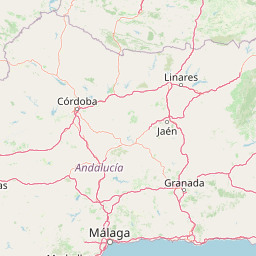
Use this park location map to pinpoint Acantilados de Maro-Cerro Gordo in Spain, understand its exact geographic position, and read its mapped placement within the surrounding landscape more clearly.

Pigeon | © OpenStreetMap contributors

Location context for Acantilados de Maro-Cerro Gordo

Andalusia
Recorded earthquake history

Explore the Earthquake History for Acantilados de Maro-Cerro Gordo

Review the historical catalogue of seismic events recorded near the coastal cliffs and marine protected areas of Acantilados de Maro-Cerro Gordo. MoriAtlas provides these records to assist with understanding regional seismic activity through structured epicentre mapping and event documentation.

Acantilados de Maro-Cerro Gordo Earthquake History

Catalogued events

128 events

Strongest magnitude

Magnitude 6.3

Most recent event

Aug 18, 2026

This history includes earthquakes recorded inside the park or within 50 km of its borders

Visual reference for Mediterranean scenery, steep headlands, and protected coves

Acantilados de Maro-Cerro Gordo Photos and Landscapes of Coastal Cliffs

Visual documentation of Acantilados de Maro-Cerro Gordo reveals the striking contrast between rugged mountain terrain and the open Mediterranean Sea. Examining real park imagery helps observers understand the dramatic scale of vertical cliffs, sheltered coves, and diverse coastal habitats.

A wide-angle, high-angle view of steep, green-sloped cliffs dropping into the deep blue Mediterranean Sea along a sunny coastline.

Park atlas

Compare adjacent coastal reserves and mountain landscapes across Andalusia

Other Parks Near Acantilados de Maro-Cerro Gordo and Protected Areas in the Region

Browsing other parks near Acantilados de Maro-Cerro Gordo reveals wider regional topography and connected protected coastlines. Comparing these nearby protected landscapes uncovers the ecological continuity shared across Mediterranean mountain and marine reserves.
Watercolor painting showing mountains, trees, and fields
National parkAndalusia
35 km away#1 closest

Northeast

Sierra Nevada National Park: Protected Alpine Terrain and Geographic Context in Andalusia

Explore Spain's highest mountain range mapped across Andalusia's atlas.

Sierra Nevada National Park offers a profound exploration of Spain's highest alpine environments and a significant entry in the regional geography atlas. This protected area showcases classic glacial landforms, U-shaped valleys, and numerous high-mountain lakes, alongside a remarkable abundance of endemic plant species thriving in its unique microclimates. Understanding its mapped boundaries reveals a landscape vital for both biodiversity and watershed, situated prominently within the broader geographic context of Andalusia.

Area
858.83 km²
Established
1999
IUCN
II
Relief
Mountain
National parkSpain
93 km away#2 closest

West

Sierra de las Nieves National Park: Ancient Fir Forests and Karst Geography in Andalusia

Mapped protected landscape and unique geologic features

Sierra de las Nieves National Park stands as a remarkable protected area in Andalusia, Spain, celebrated for its world-leading Spanish fir forests and intricate karst topography. This national park showcases significant geological diversity, from towering limestone formations and deep caves to the striking red peridotite mountains of Sierra Bermeja. Its elevation, reaching Pico Torrecilla at 1,919 meters, offers a unique alpine landscape context within southern Europe, mapped for detailed geographic discovery and protected area exploration.

Area
939.3 km²
Established
1989
IUCN
II
Visitors
100K annual
Watercolor illustration showing a landscape with green hills, vegetation, and distant mountains
National parkMorocco
About 171 km away#3 closest

South

Al Hoceima National Park: Morocco's Coastal and Marine Protected Wilderness

Explore dramatic cliffs, kelp forests, and marine biodiversity.

Al Hoceima National Park represents a significant protected coastal and marine area in northern Morocco, distinguished by its rugged 50-kilometer Mediterranean coastline featuring spectacular limestone cliffs. This national park offers an atlas-style view of a landscape transitioning from the Ibaqouyen Rif mountains to the sea, harboring rich marine biodiversity including significant osprey colonies and dolphin habitats. Discover the mapped extent of this wild protected territory and its unique ecological features.

Area
480 km²
Established
2004
IUCN
II
Relief
Mountain
Watercolor painting showing a landscape with green mountains, a river, and trees
National parkMorocco
About 211 km away#4 closest

Southwest

Talassemtane National Park: Morocco's Premier Protected Landscape and Geographic Atlas Entry

Explore its mapped boundaries and natural terrain.

Talassemtane National Park is a vital protected area contributing to the geographic diversity of Morocco. This entry focuses on its identity as a national park, detailing its mapped boundaries and providing context within the broader atlas of protected lands. Discover the specific geographic and landscape characteristics that define this Moroccan national park, offering a unique lens for regional exploration.

Area
589.5 km²
Established
2004
IUCN
II
Relief
Mountain
Watercolor illustration of a river flowing through wetlands with trees and distant hills
National parkHuelva
217 km away#5 closest

West

Doñana National Park National Park: Mapped Geography and Protected Landscape Context

Explore Huelva's key protected area and its regional geographic setting.

Delve into the structured geographic data and mapped boundaries of Doñana National Park. This entry highlights its identity as a national park within the Huelva region, providing essential context for understanding its protected landscape. MoriAtlas offers this detail to facilitate a clear, atlas-driven exploration of its natural terrain and its place in the broader geographic framework of Spain.

Area
543 km²
Established
1969
IUCN
II
Visitors
376.3K annual
Watercolor illustration showing a wetland landscape with grasses, a body of water, and distant hills
National parkSpain
261 km away#6 closest

North

Tablas de Daimiel National Park: Spain's Inland Wetland National Park and Protected Area

Explore mapped boundaries and regional geographic context.

Tablas de Daimiel National Park represents one of the last remaining examples of floodplain wetland systems in Spain's interior. Located in Castilla-La Mancha, this protected area showcases a unique confluence of fresh and brackish waters, supporting a rich mosaic of emergent vegetation and serving as a critical habitat for migratory birds. Use MoriAtlas to explore its precise geographic setting, mapped terrain, and its role as a vital conservation landscape within the Iberian Peninsula.

Area
30.3 km²
Established
1973
IUCN
II
Relief
Lowland
Watercolor painting showing green fields, scattered trees, and distant mountains under a light sky
National parkToledo Province
284 km away#7 closest

North

Cabañeros National Park: Spain's Premier Iberian Oak Woodland Protected Landscape

Mapped Geography of Montes de Toledo Protected Area

Cabañeros National Park is celebrated as the most extensive and well-conserved example of Iberian Mediterranean forest in Spain. Situated within the Montes de Toledo, the park features a remarkable dichotomy between its unique raña flatlands and mountainous sierras, harboring ancient oak woodlands and significant biodiversity. This national park serves as a crucial component of the region's geographic context and a prime destination for atlas-based discovery of protected landscapes.

Area
409 km²
Established
1995
IUCN
II
Visitors
104.6K annual
Biosphere reserveExtremadura
About 291 km away#8 closest

Northwest

La Siberia Biosphere Reserve: Mapped Geography and Protected Lands of Extremadura

A study of reservoir coastlines and Mediterranean serranías

La Siberia Biosphere Reserve offers a deep look into the rural landscape of Extremadura, Spain. Characterized by five major reservoirs and vast Mediterranean oak dehesas, the area provides essential habitat for raptors and preserves significant prehistoric rock art within its complex serranía topography. Explore the geographic boundaries and water-dominated landscape of this distinct inland region.

Area
2,836.7 km²
Established
2019
Relief
Mountain
Climate
Mediterranean

Common questions about visiting, size, designation, and location context for Acantilados de Maro-Cerro Gordo

Acantilados de Maro-Cerro Gordo FAQs for park facts, access, geography, and protected area context

Find quick answers about Acantilados de Maro-Cerro Gordo, including protected-area facts, park geography, trail and visitor context, and how the park fits into its surrounding country and regional landscape.
MoriAtlas Explorer

Continue Your Protected Areas Search Across the Global Atlas

Deepen your exploration by continuing the structured search for national parks and protected areas worldwide. Utilize the comprehensive filtering capabilities to compare different conservation landscapes and refine your understanding of global park geography. Discover more about the distribution and characteristics of protected natural areas.

Global natural geography