Mori Atlas logo
Nature reserveAltay Kokesu Wetland National Nature Reserve

A critical hydrologic refuge situated between the Altai Mountains and the Junggar Basin

Altay Kokesu Wetland National Nature Reserve: Protected Wetland Geography and Landscape Map

(Xinjiang Altay Kokesu Wetland National Nature Reserve)

The Altay Kokesu Wetland National Nature Reserve functions as a vital protected landscape where the Irtysh and Kran rivers converge. This territory spans over 300 square kilometers within the Xinjiang region, sustaining an intricate mosaic of desert, steppe, marsh, and forest patches. By mapping the interaction between snowmelt-fed rivers and diverse soil types, the reserve serves as an essential ecological buffer at the transition between arid basin lowlands and alpine mountain systems.

wetlandmarshdesert-steppe transitionriver floodplainAltai MountainsJunggar Basin

Altay Kokesu Wetland National Nature Reserve

Nature reserve

Park overview

Structured park overview, official facts, and landscape profile for Altay Kokesu Wetland National Nature Reserve

Altay Kokesu Wetland National Nature Reserve park facts, protected area profile, and essential visitor context

Review the core facts for Altay Kokesu Wetland National Nature Reserve, including designation, size, terrain, visitor scale, habitats, and operating context in one park-focused overview.

About Altay Kokesu Wetland National Nature Reserve

Altay Kokesu Wetland National Nature Reserve occupies a long, narrow stretch of desert plain in the Xinjiang Uygur Autonomous Region of northwestern China, southwest of Altay City. It sits at a geographic crossroads between two large-scale physical systems: the Altai Mountains to the north and the Junggar Basin to the south. The resulting setting produces an unusually dry continental climate with strong temperature contrasts and limited moisture, making the wetland itself stand out as a localized refuge of water and biological productivity within an otherwise arid landscape.

The reserve covers approximately 306.7 square kilometers, extending roughly 24 kilometers from east to west and more than 20 kilometers from north to south. Average elevation is about 490 meters, and the area is the lowest-lying part of the broader Altay region. Annual mean temperature hovers near 4 degrees Celsius, with recorded extremes reaching about 39.5 degrees Celsius in summer and a frigid minus 46.7 degrees Celsius in winter. Precipitation is modest, averaging under 113 millimeters per year, while evaporation can reach roughly 2000 millimeters annually, figures that highlight the marginal hydrological balance the wetland depends on.

What makes the reserve distinctive is the way the Irtysh River and the Kran River together sculpt a diverse wetland environment out of an otherwise dry plain. The Irtysh flows east to west along the southern edge of the reserve, while the Kran once had a defined channel but now loses itself across the northern part of the Kokesu wetland, spreading into marshes before eventually re-joining the Irtysh. Every spring, snowmelt swells the Irtysh, and floodwaters back up into the Kokesu system, rapidly expanding the open water area and recharging wetland soils.

This hydrology produces a striking diversity of habitats in a relatively compact area. Marshes, floodplains, salt-alkali flats, and other wetland types all occur within the reserve, while patchy soil moisture creates localized gradients of brown calcareous soil, meadow soil, aeolian sand soil, and bog soil. As a result, desert, steppe, meadow, marsh, and forest landscapes can each be found within the protected boundary, along with complex vegetation communities that include both widespread Central Asian steppe plants and narrowly endemic species such as the Burqin willow, the Altay water caltrop, and the Altay hawthorn. Set against the broader aridity of the Junggar Basin, the reserve functions as a critical node of biodiversity in a region where such wet conditions are rare and ecologically precious.

Quick facts and research context for Altay Kokesu Wetland National Nature Reserve

Altay Kokesu Wetland National Nature Reserve lies southwest of Altay City in the Xinjiang Uygur Autonomous Region, covering roughly 306.7 square kilometers at the southern edge of the Altai Mountains and the northern rim of the Junggar Basin. Established in 2001 as a provincial-level wetland reserve and elevated to national-level status in 2017, it is administered by forestry authorities of the Xinjiang Uygur Autonomous Region. The reserve was created primarily to protect the Kokesu wetland ecosystem and rare or endangered wild plants and animals, and represents the largest wetland in the Altay grassland region.

Protection and recognition

Terrestrial conservation scope, establishment timeline, and formal recognition records

Altay Kokesu Wetland National Nature Reserve Protection Status and Designation History

Altay Kokesu Wetland National Nature Reserve maintains a documented terrestrial protection status established in the year 2017. Official records outline the formal designation history and conservation scope governing this protected landscape.

Protection details

Protection scope
Terrestrial
Designated year
2017
Transboundary protection
No
Park context

Deeper park guide and search-rich context for Altay Kokesu Wetland National Nature Reserve

Altay Kokesu Wetland National Nature Reserve history, landscape, wildlife, and travel context

Explore Altay Kokesu Wetland National Nature Reserve through its history, landscape character, ecosystems, wildlife, conservation priorities, cultural context, and seasonal travel timing in a structured park guide built for atlas discovery and search intent.

Why Altay Kokesu Wetland National Nature Reserve stands out

The reserve is best known for being the largest wetland within the Altay grasslands, a complex mosaic of marshes, floodplains, salt-alkali flats, meadows, deserts, and forest patches coexisting on patchy soils within a narrow desert plain. It is also recognized for the hydrological interplay between the Irtysh and Kran rivers, whose seasonal floods sustain a winter-cold, summer-warm refuge for waterbirds, raptors, and endemic plant species such as Altay hawthorn, Burqin willow, and Altay water caltrop.

Altay Kokesu Wetland National Nature Reserve history and protected-area timeline

The Kokesu wetland has long been shaped by Irtysh and Kran River dynamics, but its formal protection history is relatively recent. The area was first designated in 2001, when the People's Government of the Xinjiang Uygur Autonomous Region established the Altay Kokesu Wetland Nature Reserve as a provincial-level protective unit, with administration vested in the regional forestry authorities.

In 2017, the State Council of the People's Republic of China upgraded the reserve to a national-level nature reserve, reflecting its growing ecological importance and the increasing pressure from human activity in the surrounding region. The upgrading also aligned the reserve with a broader national emphasis on safeguarding key wetlands and their associated species.

Alongside the designation milestones, practical conservation engineering began earlier with the 2007 launch of the Kokesu wetland ecological protection and restoration project. Using river weirs, spring flood diversion, and cross-basin water reallocation, the project sought to replenish the wetland during critical dry periods. By 2010, forage production within the wetland had begun to recover.

A complementary ecological resettlement program, initiated in 2006, gradually relocated herding households from the core area of the reserve. A notable milestone came in September 2021, when more than 260 households living in the core zone were moved into newly built housing. Together, these measures form the backbone of the reserve's modern management history and frame its ongoing challenge of balancing hydrological protection with the legacy of long-term grazing and land use in the Kokesu basin.

Altay Kokesu Wetland National Nature Reserve landscape and geographic character

The reserve is set in a long, narrow desert plain that runs roughly northwest to southeast, sandwiched between the Altai Mountains to the north and the Junggar Basin to the south. Although the broader setting is arid, the convergence of the Irtysh and Kran rivers creates a corridor of moisture, sediment, and seasonal flooding that supports wetland development on a scale unusual for the region.

Geographically, the protected area stretches about 24 kilometers east to west and more than 20 kilometers north to south, with an average elevation around 490 meters, making it the lowest-lying portion of the surrounding Altay terrain. The Irtysh River crosses the southern edge of the reserve, flowing west, while the Kran River dissipates across the northern part of the wetland, losing its defined channel and spreading water across marshes, floodplains, and salt-alkali flats before its flow eventually rejoins the Irtysh downstream.

The interplay of rivers, soils, and topography creates a striking landscape mosaic within a relatively small area. Sandy desert patches, steppe, meadow, marsh, and even small forest stands can occur side by side, supported by patchy distributions of brown calcareous, meadow, aeolian sandy, and bog soils. The result is a transitional landscape where arid and semi-arid features of the Junggar Basin meet the wetter conditions generated by snowmelt and river overflow from the Altai Mountains.

Altay Kokesu Wetland National Nature Reserve ecosystems, habitats, and plant life

The reserve's ecological identity is defined by the unusual coexistence of desert, steppe, meadow, marsh, salt-alkali flat, and forest habitats within a single protected area. Soil moisture gradients across the wetland drive this diversity, producing patchy mosaics of brown calcareous soil, meadow soil, aeolian sand soil, and bog soil. These contrasting substrates support complex vegetation communities that range from drought-tolerant desert and steppe species to moisture-loving wetland and meadow plants.

The documented vascular flora includes around 551 species distributed across 259 genera and 65 families, encompassing ferns, gymnosperms, and angiosperms. Asteraceae, Poaceae, Chenopodiaceae, Cyperaceae, Polygonaceae, Ranunculaceae, Brassicaceae, Fabaceae, Lamiaceae, and Salicaceae are among the dominant plant families, while the genus Artemisia is the most species-rich. Geographically, the flora is dominated by northern temperate elements, with notable contributions from Old World temperate, Mediterranean, and West-to-Central Asian distributions, reflecting the reserve's position at a crossroads of continental biogeographic influences.

Several endemic species are restricted to the Kokesu wetland system, including the Burqin willow, Altay water caltrop, and Altay hawthorn. The combination of structural habitat diversity, varied soils, and seasonal water pulses makes the reserve a critical biodiversity node within an otherwise arid regional setting, bridging the ecological character of the Altai mountain slopes with the dry lowlands of the Junggar Basin.

Altay Kokesu Wetland National Nature Reserve wildlife and species highlights

Wildlife in the reserve reflects its position at the meeting point of three major ecological zones: temperate marshland, temperate desert-steppe, and temperate forest. Snakes such as the red-backed rat snake and waterbirds like the little egret represent the marshland fauna, while skylarks and Mongolian hares represent the desert-steppe community, and hoopoes and sable represent the forest-based fauna. Together, these groups illustrate how a relatively compact area can support animal communities typical of very different habitat types.

Birds form the dominant vertebrate group, with 183 documented species across 36 families and 14 orders, including taxa from Falconiformes, Charadriiformes, and Anseriformes. More than half of the bird species are summer visitors, with roughly a quarter resident year-round, and the remainder made up of passage migrants and winter visitors. The reserve's avifauna represents a typical Palaearctic assemblage with relatively few species but a rich diversity of families and genera.

The reserve supports a significant number of nationally protected animals. Nine species are listed under China's highest national protection category (Class I), including the sable, black stork, great bustard, little bustard, macqueen's bustard, golden eagle, white-shouldered eagle, white-tailed eagle, and bearded vulture. An additional 39 species, such as the snow hare, Eurasian lynx, goitered gazelle, white pelican, whooper swan, hen harrier, saker falcon, merlin, and common kestrel, are listed under Class II national protection, while 126 species, including the green toad, long-eared hedgehog, and great tit, are listed under China's 'Three Categories of Protected Animals' framework. The fish fauna includes 22 species across 8 families and 5 orders, and the reserve also hosts reptiles, amphibians, and at least 238 insect species from 66 families.

Altay Kokesu Wetland National Nature Reserve conservation status and protection priorities

The reserve's conservation story is shaped by the vulnerability of a wetland system sitting at the dry edge of its climatic envelope. Its very existence depends on snowmelt pulses from the Altai Mountains and the hydrology of the Irtysh and Kran rivers, conditions that are increasingly stressed by long-term aridity, regional warming, and direct human pressures including water projects, land reclamation, overgrazing, and unregulated harvest of wild plants and animals. As these pressures intensified in the decades before formal protection, the wetland began to show signs of desertification, placing endangered plants such as salt birch, Ertix knotweed, snow-white water lily, and the Altay water caltrop at risk of local extinction, while bird and fish numbers continued to fall.

The 2001 establishment of the Altay Kokesu Wetland Nature Reserve by the Xinjiang regional government marked the first formal recognition that the wetland required active management. In 2017, the State Council elevated the site to national-level status, a step that strengthened administrative oversight and legal protection. Practical habitat restoration followed earlier, beginning with the 2007 launch of an ecological protection and restoration project that used river weirs, spring flood diversion, and cross-basin water transfers to seasonally recharge the wetland, with documented increases in forage production by 2010.

Complementing hydrological restoration, an ecological resettlement program begun in 2006 has gradually moved herding families out of the core area of the reserve, with a major milestone reached in September 2021 when more than 260 households were relocated to newly built housing. Together, these measures aim to reduce grazing pressure, restore natural hydrological cycles, and protect the regulatory and refuge functions the wetland performs for migratory waterbirds, raptors, endemic plants, and freshwater fauna within the broader dryland ecosystem of the Junggar Basin and Altai foothills.

Altay Kokesu Wetland National Nature Reserve cultural meaning and human context

The reserve's cultural context is rooted in the long-established pastoral economy of the Irtysh valley, where herding communities have traditionally used the Kokesu wetlands as seasonal grazing land. This deep entanglement between local livelihoods and wetland ecology shaped both the ecological pressures and the human geography that the reserve now seeks to manage.

The 2006 initiation of ecological resettlement, culminating in the 2021 relocation of more than 260 households from the reserve's core zone, marks a significant cultural transition. The relocation program represents a deliberate effort to re-balance centuries of grazing-based land use with the conservation needs of a nationally protected wetland, moving resident households into new settlements while gradually restoring ecological function to the most sensitive parts of the reserve.

Top sights and standout views in Altay Kokesu Wetland National Nature Reserve

Altay Kokesu Wetland National Nature Reserve's most distinctive qualities include its status as the largest wetland of the Altay grasslands and its ability to compress an unusual habitat mosaic into a single nationally protected unit. Desert, steppe, meadow, marsh, salt-alkali flat, and forest all coexist within its roughly 307-square-kilometer boundary, made possible by patchy soil mosaics and the hydrological interaction of the Irtysh and Kran rivers.

The reserve is also distinguished by the seasonal drama of its spring snowmelt floods, which rapidly swell the wetland's open water and recharge its soils, sustaining globally significant bird populations and endemic plant species such as Burqin willow, Altay water caltrop, and Altay hawthorn. Combined with a Class I protected species roster that includes the black stork, golden eagle, white-shouldered eagle, and great bustard, these features make the reserve a critical refuge at the interface between the Altai Mountains and the Junggar Basin.

Best time to visit Altay Kokesu Wetland National Nature Reserve

The most visually and ecologically dynamic period in the reserve is spring, when snowmelt from the Altai Mountains swells the Irtysh River and floodwaters back up into the Kokesu system. During this season the wetland's open water area expands rapidly, waterfowl and migratory birds become most active, and the landscape shows its fullest range of wet conditions.

Summer brings warm temperatures and the highest concentration of summer-breeding birds, while the surrounding steppe and meadow habitats are at their most vegetatively expressive. Winter is harsh, with recorded temperatures falling below minus 40 degrees Celsius, and is generally not conducive to comfortable exploration. The transitional spring and early-to-mid summer months therefore offer the most rewarding combination of active hydrology, rich birdlife, and relatively accessible weather for those interested in the wetland's defining character.

Monthly climate preview

Long-term representative monthly temperature and precipitation rhythm

Altay Kokesu Wetland National Nature Reserve Climate and Temperature Normals

Representative coordinate records show significant annual temperature swings alongside measured monthly precipitation patterns across the protected landscape. Examining the full twelve-month profile reveals detailed baseline data for ongoing conservation and regional research.
Annual mean7 °C
-13 °C25 °C
Jan-13°
Feb-9°
Mar
Apr10°
May17°
Jun23°
Jul25°
Aug23°
Sep16°
Oct
Nov-3°
Dec-10°
Warmest month
July

25.4 °C

Coolest month
January

-13.1 °C

Wettest month
July

0.7 mm/day

Driest month
March

0.3 mm/day

Park location guide

Geography guide, regional context, and park location map for Altay Kokesu Wetland National Nature Reserve

Altay Kokesu Wetland National Nature Reserve park geography, regions, and map view in China

Understand where Altay Kokesu Wetland National Nature Reserve sits in China through a broader geographic reading of the surrounding landscape, nearby location context, and its mapped position within the national park landscape.

How Altay Kokesu Wetland National Nature Reserve fits into China

China is a unitary communist state in East Asia, governed by the Chinese Communist Party. The country's capital is Beijing, while Shanghai is the largest city by urban population. China has 33 province-level divisions including provinces, autonomous regions, municipalities, and special administrative regions. The nation has a long history spanning thousands of years, with achievements including the invention of gunpowder, paper, printing, and the compass.

Wider geography shaping Altay Kokesu Wetland National Nature Reserve in China

China is located in East Asia, bordering fourteen countries: Russia, North Korea, Vietnam, Laos, Myanmar, India, Bhutan, Nepal, Pakistan, Afghanistan, Tajikistan, Kyrgyzstan, Kazakhstan, and Mongolia. The country spans diverse terrain including deserts, mountains, plateaus, and river valleys. Major river systems include the Yellow River and Yangtze River. The coastline stretches along the East China Sea, South China Sea, and Yellow Sea.

Map view of Altay Kokesu Wetland National Nature Reserve

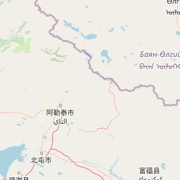
Use this park location map to pinpoint Altay Kokesu Wetland National Nature Reserve in China, understand its exact geographic position, and read its mapped placement within the surrounding landscape more clearly.

Pigeon | © OpenStreetMap contributors

Location context for Altay Kokesu Wetland National Nature Reserve

Xinjiang
Park atlas

Compare adjacent wetland reserves and desert-steppe transition zones across the surrounding Altai terrain.

Explore Other Parks Near Altay Kokesu Wetland National Nature Reserve for Regional Protected Landscapes

Browse nearby national parks and protected areas sharing the transitional geography of the Altai Mountains and the Junggar Basin. Extending geographic comparison beyond Altay Kokesu Wetland National Nature Reserve reveals broader patterns in regional watershed and grassland habitats.
National parkBayan-Ölgii Province
About 101 km away#1 closest

Northeast

Altai Tavan Bogd National Park: Protected Mountainous Landscape in Bayan-Ölgii

Explore mapped geography and protected terrain.

Altai Tavan Bogd National Park, situated in Mongolia's Bayan-Ölgii Province, offers a detailed view of a significant protected natural area. This park is defined by its mountainous geography, forming a key part of the Altai range. Users can explore its mapped boundaries and understand its role as a protected landscape within the western Mongolian atlas.

Area
6,362 km²
Established
1996
IUCN
II
Relief
Mountain
Watercolor painting of a river flowing through forested hills with mountains in the background under a sunset sky
National parkEast Kazakhstan Region
About 149 km away#2 closest

North

Katon-Karagay National Park: Discover Kazakhstan's Largest Protected Mountain Landscape

Explore the geography and park boundaries of East Kazakhstan's premier national park.

Katon-Karagay National Park, the largest national park in Kazakhstan, offers a deep dive into the protected landscapes of the Southern Altai Mountains. This page provides essential geographic context, detailing the park's terrain, its significance as a protected area within East Kazakhstan Region, and its role in mapping the natural contours of this ecologically diverse mountain system. Understand the park's boundaries and its contribution to regional conservation.

Area
6,435 km²
Established
2001
IUCN
II
Relief
Mountain
A soft watercolor painting of a serene river winding through a grassy valley toward distant hazy mountains, with evergreen trees dotting the landscape.
Nature reserveEast Kazakhstan Region
About 177 km away#3 closest

Northwest

Markakol Nature Reserve: Mapping the Protected Mountain Landscapes of East Kazakhstan

High-altitude glacial lake and alpine tundra ecosystems

Markakol Nature Reserve protects a remote tectonic depression within the Southern Altai. The area features a complex vertical zonation of fir and spruce forests, subalpine meadows, and alpine tundra, centered around the pristine and ecologically significant Lake Markakol. This protected site serves as a vital study of the intersection between Siberian boreal influences and high-mountain steppe biodiversity.

Area
1,029.71 km²
Established
1976
IUCN
Ia
Relief
Mountain
Watercolor painting showing green mountains, valleys, and a winding river under a light sky
National parkAltai Republic
About 219 km away#4 closest

North

Saylyugemsky National Park: Discover its Protected Landscape and Geographic Significance in Altai Republic

Mapped boundaries and regional landscape context within the Altai Republic.

Delve into Saylyugemsky National Park, a designated national park situated within the vast geographic expanse of Russia's Altai Republic. This canonical page provides detailed insights into its protected landscape, meticulously mapped boundaries, and its contribution to the regional geography. MoriAtlas focuses on structured geographic discovery, enabling a deeper understanding of Saylyugemsky National Park's place within the atlas of protected areas and natural landscapes.

Area
1,183.8 km²
Established
2012
IUCN
II
Relief
Mountain
National parkBayan-Ölgii Province
About 280 km away#5 closest

Northeast

Tsambagarav Uul National Park: Mapped Protected Landscape in Bayan-Ölgii

Explore its geographic context and park boundaries.

Tsambagarav Uul National Park offers a detailed look at a significant protected landscape situated in Mongolia's western Bayan-Ölgii Province. This national park's boundaries are mapped to provide context within the broader Altai Mountains region. Users can explore the park's geographic setting, understanding its contribution to the protected natural areas of western Mongolia and its significance for regional landscape studies.

Area
1,110 km²
Established
2000
IUCN
II
Relief
Mountain
Nature reserveAltay Prefecture
About 298 km away#6 closest

Southeast

Xinjiang Bulgan Beaver National Nature Reserve: Regional Geography and Protected Landscape Map

Exploring riverine habitats in the Altay Prefecture foothills.

This protected area centers on a narrow, vital corridor along the Bulgan River. Discover how the riparian forests, freshwater meadows, and valley plains of this nature reserve provide a refuge for the Mengxin beaver. The mapping details a unique, species-focused sanctuary situated along the Sino-Mongolian border within the broader Altai Mountain landscape.

Area
50 km²
Established
1980
Relief
Upland
Climate
Arid
National parkKhovd Province
About 329 km away#7 closest

Southeast

Bulgan Gol-Ikh Ongog National Park: Khovd Province's Vital Riparian Protected Landscape

Mapped geography of river valley, wetlands, and desert steppe.

Bulgan Gol-Ikh Ongog National Park is a designated national park situated in the Khovd Province of western Mongolia, focusing on the preservation of the Bulgan River valley. This protected landscape features a distinctive desert steppe environment interwoven with extensive riparian wetlands, islands, and river channels. The park is ecologically significant as a crucial migratory bird stopover point, supporting diverse habitats that highlight the transition from mountainous sources to the flatter valley floor, offering unique atlas-level geographic insight.

Area
2,461 km²
Established
2011
IUCN
II
Relief
Lowland
National parkEast Kazakhstan Region
About 365 km away#8 closest

West

Tarbagatai National Park: Protected Landscape and Wild Fruit Tree Forests in East Kazakhstan Region

Explore the mapped boundaries and ecosystem of this national park.

Tarbagatai National Park is a protected area in East Kazakhstan recognized for its unique role in conserving wild fruit tree forests that have maintained genetic isolation. This national park provides a detailed view of a mountain-steppe ecosystem across the Tarbagatai mountain range, Karabas Mountains, and Arkaly Mountains, along with the Urzhar and Emel river valleys. Its establishment in 2018 highlights its importance for biodiversity and the study of natural forest genetics, offering significant geographic context for regional protected land exploration.

Area
1,364 km²
Established
2018
IUCN
II
Relief
Mountain

Common questions about visiting, size, designation, and location context for Altay Kokesu Wetland National Nature Reserve

Altay Kokesu Wetland National Nature Reserve FAQs for park facts, access, geography, and protected area context

Find quick answers about Altay Kokesu Wetland National Nature Reserve, including protected-area facts, park geography, trail and visitor context, and how the park fits into its surrounding country and regional landscape.
MoriAtlas Explorer

Continue Your Protected Areas Search Across the Global Atlas

Deepen your exploration by continuing the structured search for national parks and protected areas worldwide. Utilize the comprehensive filtering capabilities to compare different conservation landscapes and refine your understanding of global park geography. Discover more about the distribution and characteristics of protected natural areas.

Global natural geography