Why Amager Fælled stands out
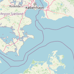
Amager Fælled is best known for being a large, unexpectedly wild green space inside Greater Copenhagen, where pioneer plants grow on chalky and debris-strewn soils and where rare coastal-meadow habitats persist right next to new urban districts. It stands out as a place where cattle still graze in summer, birdwatchers gather around Grønjordssøen, and citizens walk dogs just a short distance from high-rise development in Ørestad. The reserve is equally well known for the political fight over the beach meadow (strandengen), where proposed development gave way, after intense public debate, to national protection in 2019. That combination of unplanned urban nature, rare species habitat, and a contested planning history defines the area's modern identity.

Amager Fælled history and protected-area timeline
Amager Fælled has a layered history rooted in 17th-century military use. From 1673 onward, the area served as a firing range, with soldiers practicing from the northern end toward the south on Saturdays. Fixed batteries were constructed in 1765, and between 1830 and 1867 a shooting range was established east of what is now H/F Bryggen. During the same period, Artillerivej was built as a dike running along the then-coastline down toward where the Bella Center now stands.
During the agricultural reforms of the late 18th century, the so-called udskiftning of Amager Fælled in 1784–85 gave the municipality rights to graze livestock on the land. Amager Fælled also hosted one of Copenhagen's execution grounds, where the city's final execution took place in 1845.
By the early 20th century, the area's character began to shift toward landfill and urban expansion. The first documented refuse site dates to 1884, and more substantial filling began after 1900, creating the foundations of Islands Brygge. Later, from 1930 onward, household waste, industrial waste, soil, and construction debris were dumped into the wetter parts of the area, and from 1945 a formal landfill operated at the end of Artillerivej, eventually extending both eastward and southward. The landfill closed in 1974. Industrial-scale deposition of sludge and liquid chemical waste took place from 1960 onward, leaving methane issues still detectable today in allotment gardens like H/F Sønderbro.
Military use of the area continued until the 1950s, when the army relocated to Kalvebod Fælled. Damp, poorly drained ground meant that not all munitions detonated, and major clearance operations were carried out in 2000 and 2015, with residual ammunition still occasionally found in the area.
The conservation story is newer. In 1990 the southwestern inland portion was protected alongside the adjacent Kalvebod Fælled, and in 1992 the Danish Nature Conservation Association drove a broader protection settlement covering previously unfilled land. The very next day, however, the municipality and central government lifted protection from the beach meadow via legislation, leaving only the western inland area formally protected. Planning frameworks later allowed the municipality to permit development on parts of the beach meadow, but major public opposition forced the city in September 2017 to abandon its building plans. In March 2019 the Danish parliament extended protection to the beach meadow while simultaneously deprotecting three other zones, including the Lærkesletten area near the hostel.
Amager Fælled landscape and geographic character
Amager Fælled's landscape is the product of centuries of human layering on top of low-lying coastal terrain. The lowest parts flood easily, and the historical presence of dykes, including traces of an old dike line along what is now Digevej, reflects the area's vulnerable relationship with the sea.
In terms of surface geology, much of the reserve is built on clay- and chalk-rich subsoil overlaid with historic construction debris and household refuse. These substrates are notably low in organic material, creating thin, drought-prone soils that favor pioneer plant communities and unusual habitat mosaics. Where original topsoil survives, typically along a strip of ancient coastal meadow to the east and in older reed-fringe areas north of the main fill zones, vegetation is taller and more closed, including genuine wooded patches.
Hydrological features shape the visual experience too. The small lake Grønjordssøen sits within the area, and a newly constructed canal adds a more recent artificial water feature. The relief is generally low and gently undulating, but the contrast between flat, open filled ground and greener meadow and woodland strips gives the reserve an unexpectedly varied visual character for a site so close to the center of Copenhagen.
Amager Fælled ecosystems, habitats, and plant life
Ecologically, Amager Fælled is a mosaic rather than a single habitat. The substrate is dominated by thin, clay- and chalk-rich raw soils and by older building waste, both of which are low in organic content. That condition normally limits plant growth but, conversely, creates ideal conditions for pioneer species adapted to disturbed, nutrient-poor ground.
Where human deposits are deepest, vegetation is sparse and short. Where original topsoil is preserved, especially in the eastern strip of ancient coastal meadow and in older reed-fringe zones, growth is denser and more structurally complex, with patches of developed woodland that contrast sharply with the open fill zones.
The reserve is recognized as habitat for a notable number of red-listed and EU-protected species spanning plants, fungi, amphibians, and insects. The combination of dry, raw-soil habitat, wetter meadow and reed zones, and small open water in Grønjordssøen supports a wide ecological range within a relatively compact, heavily urban-adjacent area.
Amager Fælled wildlife and species highlights
Wildlife interest at Amager Fælled is diverse despite the urban surroundings. The reserve supports red-listed and EU-protected flora and fungi, especially in the pioneer habitats of the chalky and debris-rich soils. Insects and other invertebrates typical of early-succession, open-ground habitats are a particular feature, taking advantage of the warm, thin soils.
Amphibians find suitable conditions in the wetter zones, including older reed beds and the margins of Grønjordssøen, while the mosaic of dry fill, meadow, and small open water supports a varied bird community that draws birdwatchers to the area in all seasons. The presence of grazing cattle during summer adds disturbance patterns that further shape invertebrate and bird use of the grasslands.
Amager Fælled conservation status and protection priorities
Conservation is central to Amager Fælled's modern identity. The inland southwestern portion received protection in 1990, and a broader 1992 protection ruling covered previously unfilled areas, though the beach-meadow portion was deprotected almost immediately afterward to allow possible development.
The area's conservation value rests on a rare and ecologically important mosaic: pioneer plant habitats on chalky and debris-rich soils, surviving ancient coastal meadow, older reed zones, and small open water. These features together support a significant number of red-listed and EU-protected species.
The political dimension is unusually prominent. After years of debate and public opposition, including significant media coverage ahead of the 2017 municipal elections, the city of Copenhagen abandoned plans to build on the beach meadow. In March 2019 the Danish parliament passed national protection for the beach meadow but, as part of the same process, deprotected three other zones, including the area known as Lærkesletten around the hostel. The result is a legally complex but ecologically significant reserve that remains one of Copenhagen's most important urban nature areas.
Amager Fælled cultural meaning and human context
Amager Fælled is deeply woven into the cultural and planning history of Copenhagen. The island of Amager has long been associated with agricultural land use around the capital, and the fælled, or common land, reflects older patterns of communal grazing that predate modern urban planning.
The area also carries a heavy military and ceremonial past, including the site of Copenhagen's executions until 1845, and later a long history as a military firing range and, from the early 20th century onward, a major urban landfill. These layers, military ground, refuse site, allotment gardens, and finally protected nature, are part of how Copenhageners experience the site today.
In recent decades, Amager Fælled has become a symbol in local politics, where debates over the future of the beach meadow mobilized large segments of the public and shaped the 2017 municipal election. The reserve stands as a contemporary example of how a capital city's communities negotiate urban growth, public access to green space, and the protection of biodiversity within the built environment.
Top sights and standout views in Amager Fælled
A large protected nature reserve of about 223 hectares embedded between Copenhagen and Ørestad; a striking mosaic of pioneer habitats on chalky, debris-rich soils and surviving ancient coastal meadow; important habitat for red-listed and EU-protected flora, fungi, amphibians, and insects; a heavily used recreational space that still hosts grazing cattle in summer and birdwatchers year-round; and an unusually visible conservation history, culminating in the 2019 national protection of the long-contested beach meadow.
Best time to visit Amager Fælled
Spring and early summer are often rewarding for birdwatching around Grønjordssøen and the wetter meadow zones, while summer brings the distinctive sight of grazing cattle on the open ground and the most active pioneer-plant and insect communities. Autumn offers quieter conditions and shifting views from the elevated Ørestad edge, and winter visits highlight the openness of the meadow and the contrast between the reserve and the surrounding city. Because the area is used heavily by city residents year-round, timing visits for quieter weekday mornings generally gives a calmer experience.