

Mori Atlas logo
National parkAshizuri-Uwakai National Park

Discover the mapped boundaries and natural landscape context of this key protected area.

Ashizuri-Uwakai National Park: A Protected National Park in Japan's Geographic Atlas

(Ashizuri Uwakai Kokuritsu Kōen)

Ashizuri-Uwakai National Park represents a significant protected landscape within Japan's diverse geography. This national park offers a distinct focus for atlas-based exploration, allowing users to understand its mapped boundaries, its role as a protected area, and its contribution to the regional natural landscape context. As a designated national park, its identity is rooted in providing a structured entry point for comprehending Japan's protected territories and their geographic significance.

Coastal LandscapeSubtropical EnvironmentGranite CliffsMarine ProtectionPacific OceanShikoku Island

Ashizuri-Uwakai National Park

National park

Park overview

Structured park overview, official facts, and landscape profile for Ashizuri-Uwakai National Park

Ashizuri-Uwakai National Park park facts, protected area profile, and essential visitor context
Review the core facts for Ashizuri-Uwakai National Park, including designation, size, terrain, visitor scale, habitats, and operating context in one park-focused overview.

About Ashizuri-Uwakai National Park

Ashizuri-Uwakai National Park occupies a distinctive position along Japan's southwestern coastline, protecting a stretch of terrain where the Pacific Ocean has carved a rugged shoreline of cliffs, coves, and scattered islands. The park's territory extends across both Ehime and Kōchi prefectures, with the majority of protected land situated along the coast. Cape Ashizuri serves as the park's geographical and symbolic center, a place where visitors can stand at Shikoku's southernmost point and observe the powerful interplay of ocean and granite that has shaped this landscape over millennia. The area originally drew consideration under the name Inan Kaigan before being officially designated, eventually taking the name Ashizuri from the prominent cape. The park's designation evolved from quasi-national park status in 1955 to full national park status in 1972, when the Uwakai coastal region was incorporated into the protected area. This expansion added significant marine environments to the park's holdings, creating a more comprehensive coastal protection zone that addresses both terrestrial and ocean ecosystems.

Quick facts and research context for Ashizuri-Uwakai National Park

Ashizuri-Uwakai National Park covers approximately 113 square kilometers along the southwestern coast of Shikoku island in Japan. The park spans two prefectures, Ehime and Kōchi, and was officially designated as a national park on November 10, 1972, having previously existed as a quasi-national park since 1955. The area is classified under IUCN Category II and is managed by Japan's Ministry of the Environment. Cape Ashizuri serves as the park's central landmark, representing the southernmost point of Shikoku and offering panoramic views of the Pacific Ocean from its granite cliff formations. The park features multiple designated marine areas protecting the coastal waters, and inland sections include mountainous terrain with valleys such as Nametoko.

Park context

Deeper park guide and search-rich context for Ashizuri-Uwakai National Park

Ashizuri-Uwakai National Park history, landscape, wildlife, and travel context
Explore Ashizuri-Uwakai National Park through its history, landscape character, ecosystems, wildlife, conservation priorities, cultural context, and seasonal travel timing in a structured park guide built for atlas discovery and search intent.

Why Ashizuri-Uwakai National Park stands out

Ashizuri-Uwakai National Park is best known for Cape Ashizuri, the prominent southernmost headland of Shikoku island, where massive granite cliffs meet the Pacific Ocean in a dramatic display of coastal geology. The cape supports extensive subtropical vegetation that creates a lush green backdrop against the darker rock formations and blue ocean waters. This combination of subtropical plant life with the rugged cliff scenery distinguishes the park from Japan's more northern protected areas. The park also contains several marine parks protecting underwater environments around Tatsukushi, Kashiwajima, and other coastal areas, making it significant for both terrestrial and marine conservation.

Ashizuri-Uwakai National Park history and protected-area timeline

The protected area that would become Ashizuri-Uwakai National Park traces its formal history to April 1, 1955, when the region was first designated as Ashizuri Quasi-National Park. This initial protected status reflected recognition of the area's outstanding natural scenery and the need to preserve its distinctive coastal landscape. For nearly two decades, the quasi-national park designation provided baseline protection while the region continued to develop as a destination for visitors seeking to experience Shikoku's southern coast. In 1972, the park was elevated to full national park status, a transformation that brought increased resources for management and conservation while expanding the protected territory to include the Uwakai coastal region. This expansion marked a significant moment in the park's evolution, broadening the scope of protection to encompass marine environments and adding new sections of coastline to the park's domain. The official name changed at this time to Ashizuri-Uwakai National Park, reflecting the incorporation of the Uwakai area. The park's historical significance extends beyond its protected status to include the story of Nakahama Manjiro, who was born in the vicinity of the park and later became the first Japanese person to visit the United States after being shipwrecked and rescued by an American whaling ship.

Ashizuri-Uwakai National Park landscape and geographic character

The landscape of Ashizuri-Uwakai National Park is characterized by a dramatic interface between land and sea, where granite cliffs and rocky headlands meet the waters of the Pacific Ocean. Cape Ashizuri represents the most spectacular expression of this geological character, with its steep cliffs dropping sharply into the sea and offering commanding views across the oceanic expanse. The coastline features numerous smaller headlands, coves, and beaches that create visual variety along the protected shore. Inland from the coast, the terrain rises into mountainous areas that include peaks such as Shinoyama and the Hoketsu Pass, which provides an elevated vantage point for viewing the Uwakai coastline below. The park also encompasses valley systems like Nametoko, where steep-walled gorges contain streams and waterfalls including the snow-patterned cascade known as Settsurin Falls. The presence of islands such as Kashiwajima and Okinoshima offshore adds further dimension to the park's maritime landscape, while coastal features like Odora Beach and Takamo Cape extend the range of scenic environments within the protected area.

Ashizuri-Uwakai National Park ecosystems, habitats, and plant life

The ecological character of Ashizuri-Uwakai National Park reflects its position at the southern edge of Shikoku, where subtropical influences shape the vegetation and overall environmental character. The park's location allows plant species typical of warmer climates to thrive here, creating a naturalistic context quite different from the more temperate environments found in northern Japan. The granite-dominated terrain supports a variety of plant communities adapted to the coastal setting, with the cliff faces and surrounding areas displaying vegetation patterns shaped by ocean exposure, salt spray, and the underlying rock substrate. Beyond the terrestrial environments, the park's marine ecosystems represent a significant component of its natural value, with multiple underwater areas designated for protection. The marine parks at Tatsukushi, Kashinishi, Kinzaki, Shiriokubi, Uwakai, and Okinoshima each protect different aspects of the coastal and nearshore environment, supporting marine biodiversity in the waters that border the park.

Ashizuri-Uwakai National Park wildlife and species highlights

The wildlife of Ashizuri-Uwakai National Park benefits from the diversity of habitats contained within its boundaries, ranging from cliff and coastal environments to offshore marine waters. While specific species details require more detailed source material, the park's position in a subtropical zone and its mixture of terrestrial and marine environments suggest a rich assemblage of wildlife adapted to these coastal ecosystems. The marine parks within the protected area provide important habitat for various marine species, while the cliff environments offer nesting opportunities for seabirds and other coastal wildlife. The surrounding waters of the Pacific Ocean serve as a migratory corridor and feeding area for marine life that moves through the region.

Ashizuri-Uwakai National Park conservation status and protection priorities

Ashizuri-Uwakai National Park serves as a protected framework for a significant stretch of Japan's southwestern coastline, preserving both terrestrial and marine environments within a single conservation designation. The park's dual focus on land and sea reflects a broader recognition that effective coastal protection must address the interconnected nature of terrestrial runoff, nearshore waters, and the marine ecosystems they support. The designation of six separate marine parks within the larger protected area demonstrates a commitment to comprehensive coastal management that extends protection below the waterline. The transition from quasi-national park to full national park status in 1972 brought additional regulatory framework and management resources to support conservation objectives. The ongoing management by Japan's Ministry of the Environment through its Chugoku-Shikoku Regional Office ensures coordinated oversight of the park's diverse components.

Ashizuri-Uwakai National Park cultural meaning and human context

The cultural landscape of Ashizuri-Uwakai National Park carries historical resonance that extends beyond its natural features to encompass significant moments in Japanese history. The area is notably connected to Nakahama Manjiro, who was born in the region and whose story became a pivotal moment in Japanese engagement with the wider world. Manjiro's shipwreck and subsequent rescue by an American whaling vessel in the waters near what is now the national park led to his becoming the first Japanese citizen to visit and live in the United States. His subsequent role as a translator and cultural intermediary between Japan and America represents a meaningful thread in the broader history of Japan's opening to the world during the Meiji era. This historical dimension adds cultural depth to the park's natural significance, creating a place where geological and ecological values intersect with human history.

Top sights and standout views in Ashizuri-Uwakai National Park

The park's highlights center on the dramatic meeting of land and sea along Shikoku's southwestern coast. Cape Ashizuri stands as the premier viewpoint, where visitors can experience the full force of the Pacific against ancient granite cliffs while standing at the island's southernmost point. The marine environment offers equally compelling experiences, with diving and snorkeling opportunities in the protected waters around Tatsukushi and the other marine parks. The elevated perspective from Hoketsu Pass provides sweeping views of the Uwakai coastline, while the interior valleys of Nametoko offer a different character where steep gorge walls and waterfalls create a mountainous counterpoint to the coastal scenery. Kashiwajima and the other offshore islands add further exploration possibilities for visitors interested in experiencing the full extent of the park's marine and terrestrial diversity.

Best time to visit Ashizuri-Uwakai National Park

The optimal time to experience Ashizuri-Uwakai National Park depends on what visitors hope to observe, though the subtropical climate of Shikoku's southern coast allows for year-round access to the park's outdoor environments. Spring and autumn typically offer comfortable temperatures for hiking and coastal exploration, with fewer crowds than the summer months when Japanese vacationers flock to the coast. The subtropical vegetation maintains its greenery throughout the year, though winter may bring cooler conditions that reduce some visitor activities. Summer months bring warmer temperatures and the possibility of ocean swimming, though the park's dramatic cliff scenery can be appreciated in any season. The marine environments may offer different experiences depending on water temperature and visibility, which vary throughout the year.
Park location guide

Geography guide, regional context, and park location map for Ashizuri-Uwakai National Park

Ashizuri-Uwakai National Park park geography, regions, and map view in Japan
Understand where Ashizuri-Uwakai National Park sits in Japan through a broader geographic reading of the surrounding landscape, nearby location context, and its mapped position within the national park landscape.

How Ashizuri-Uwakai National Park fits into Japan

Japan is an island nation in East Asia comprising over 14,000 islands in the Pacific Ocean. The country operates as a unitary parliamentary constitutional monarchy with Emperor Naruhito as the reigning monarch and Prime Minister Sanae Takaichi leading the government. With a population of approximately 123 million, Japan is the world's 11th most populous country and a major economic power with one of the strongest militaries, though it has constitutionally renounced its right to declare war.

Wider geography shaping Ashizuri-Uwakai National Park in Japan

Japan is an island nation in the Pacific Ocean, bordered to the west by the Sea of Japan and extending from the Sea of Okhotsk in the north to the East China Sea in the south. The Japanese archipelago lies off the northeast coast of the Asian mainland. Approximately 75% of Japan's terrain is mountainous and heavily forested, with agricultural land and urbanized populations concentrated along the eastern coastal plains. The country is divided into 47 administrative prefectures and eight traditional regions.

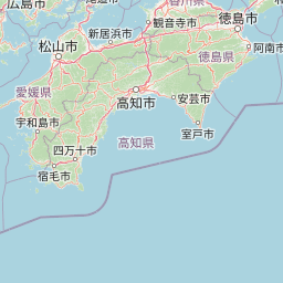
Map view of Ashizuri-Uwakai National Park

Use this park location map to pinpoint Ashizuri-Uwakai National Park in Japan, understand its exact geographic position, and read its mapped placement within the surrounding landscape more clearly.

Pigeon | © OpenStreetMap contributors

Location context for Ashizuri-Uwakai National Park

Ehime PrefectureKōchi Prefecture
Park atlas

Compare adjacent protected landscapes, from dramatic granite cliffs to tranquil marine parks, complementing the unique coastal geography of Ashizuri-Uwakai.

Compare National Parks: Exploring Protected Areas Near Ashizuri-Uwakai National Park
Browse national parks and protected areas in the geographic vicinity of Ashizuri-Uwakai National Park, featuring diverse coastal, marine, and mountain landscapes across Shikoku. Compare these protected areas directly to understand regional environmental patterns, conservation approaches, and their unique place in Japan's atlas of natural heritage.
National parkJapan

Setonaikai National Park: Japan's Premier Island Archipelago and Coastal Protected Landscape

Explore the unique marine geography and mapped island environments.

Setonaikai National Park is Japan's largest national park, renowned for its stunning marine environment within the Seto Inland Sea. This protected area features approximately 3,000 islands, showcasing weathered granite formations, coastal forests, and dynamic tidal phenomena like the Naruto whirlpools. The park offers a unique atlas-style exploration of island geography, coastal landscapes, and significant cultural sites, making it a cornerstone of Japan's protected natural heritage.

Area
669.34 km²
Established
1934
IUCN
II
Visitors
40.6M annual
National parkŌita Prefecture

Aso-Kujū National Park: Ōita Prefecture's Protected Landscape Atlas

Mapped boundaries and regional geographic context for this national park.

Delve into the protected landscape of Aso-Kujū National Park, situated within the geographic region of Ōita Prefecture. This page provides detailed insight into the park's mapped terrain, its designation as a national park, and its contribution to the atlas of protected areas. Understand the park's landscape context and its significance as a conserved natural area.

Area
726.78 km²
Established
1934
IUCN
II
Relief
Mountain
National parkNagasaki Prefecture

Unzen-Amakusa National Park: Volcanic Terrain and Island Geography

Explore Nagasaki Prefecture's Protected Landscape

Unzen-Amakusa National Park represents a significant protected area within Japan's geography, characterized by the imposing presence of Mount Unzen and the distinct maritime environment of the Amakusa islands. This national park offers an opportunity to study volcanic landscapes, coastal formations, and the rich cultural history intertwined with its natural setting. Understanding its mapped boundaries and geographic context provides valuable insight into Japan's protected lands and regional landscape diversity.

Area
282.79 km²
Established
1934
IUCN
II
Relief
Mixed relief
National parkJapan

Kirishima-Kinkowan National Park: Exploring Japan's National Park Geography and Mapped Boundaries

A protected landscape within Japan's diverse terrain.

Kirishima-Kinkowan National Park represents a distinct protected area within Japan, offering critical insights for geographic exploration. This page details the park's specific mapped boundaries and its contribution to the regional landscape. Understanding this national park provides a structured entry point for exploring Japan's protected natural areas and their unique geographical characteristics through an atlas lens.

Area
365.86 km²
Established
1934
IUCN
II
Relief
Mountain
National parkKansai

Yoshino-Kumano National Park: Protected National Park with Sacred Mountain Landscapes and Ancient Routes

Explore mapped park boundaries, gorges, and pilgrimage routes in Kansai.

Yoshino-Kumano National Park, a significant national park in Japan's Kansai region, invites exploration of its protected landscapes, which are deeply intertwined with spiritual heritage. Discover the park's rugged mountain terrain, ancient cypress and cedar forests, dramatic gorges like Dorokyō Gorge, and iconic coastal areas. This park is a vital entry for understanding Japan's confluence of natural geography and cultural pilgrimage, offering rich context for mapped landscape discovery.

Area
616.04 km²
Established
1936
IUCN
II
Relief
Mountain
National parkChūgoku region

Daisen-Oki National Park: A National Park within the Chūgoku Region's Protected Landscape Atlas

Mapped geography and protected land context.

Gain a structured understanding of Daisen-Oki National Park, a designated national park situated in Japan's Chūgoku region. This entry focuses on its precise geographic location, mapped protected boundaries, and its role within a broader landscape atlas. Explore the fundamental geographic characteristics that define this key natural area, providing essential context for regional and national park discovery.

Area
694.105 km²
Established
1936
IUCN
II
Visitors
9.3M annual
National parkKagoshima Prefecture

Yakushima National Park: Ancient Cedar Forests and Volcanic Mountain Landscape

Discover the mapped boundaries and protected area geography.

Yakushima National Park, situated in Kagoshima Prefecture, is a prime example of protected island geography, renowned for its ancient yakusugi cedar trees and dramatic mountainous terrain. The park's protected status covers over 32,000 hectares, featuring peaks over 1,900 meters and significant biodiversity. This atlas-focused entry helps users grasp the park's unique landscape context, its position within Japan's protected areas, and the essence of its natural environment for geographic exploration.

Area
325.53 km²
Established
2012
IUCN
II
Relief
Mountain
National parkNagasaki Prefecture

Saikai National Park: Japan National Park Geography and Protected Area Mapping

Explore Nagasaki Prefecture's protected natural landscapes.

Delve into the detailed geographic information and protected area context of Saikai National Park. As a national park situated in Nagasaki Prefecture, it represents a key area for understanding Japan's regional geography and its network of protected lands. This entry facilitates atlas-based discovery of the park's boundaries, its terrain, and its unique role within the mapped landscape of Kyushu.

Area
246.46 km²
Established
1955
IUCN
II
Visitors
4.6M annual

Common questions about visiting, size, designation, and location context for Ashizuri-Uwakai National Park

Ashizuri-Uwakai National Park FAQs for park facts, access, geography, and protected area context
Find quick answers about Ashizuri-Uwakai National Park, including protected-area facts, park geography, trail and visitor context, and how the park fits into its surrounding country and regional landscape.
MoriAtlas Explorer

Continue Your Protected Areas Search Across the Global Atlas

Deepen your exploration by continuing the structured search for national parks and protected areas worldwide. Utilize the comprehensive filtering capabilities to compare different conservation landscapes and refine your understanding of global park geography. Discover more about the distribution and characteristics of protected natural areas.

Global natural geography
Ashizuri-Uwakai National Park: Japan's Protected Landscape Atlas