

Mori Atlas logo
National parkBaluran National Park

Explore the mapped boundaries and natural terrain of this national park in Situbondo Regency.

Baluran National Park: Indonesia's Protected Landscape and Regional Geography

(Taman Nasional Baluran)

Baluran National Park stands as a significant protected area within Indonesia, offering a unique glimpse into the nation's natural landscapes. Situated within Situbondo Regency, this national park is defined by its distinct geographic setting, inviting detailed atlas-driven exploration. Understanding Baluran National Park involves examining its mapped boundaries and the surrounding terrain, providing crucial context for its place within regional geography and the broader MoriAtlas discovery platform.

savanna ecosystemvolcanic landscapebanteng conservationdry climate parkcoastal ecosystemsEast Java parks

Baluran National Park

National park

Park overview

Structured park overview, official facts, and landscape profile for Baluran National Park

Baluran National Park park facts, protected area profile, and essential visitor context

Review the core facts for Baluran National Park, including designation, size, terrain, visitor scale, habitats, and operating context in one park-focused overview.

About Baluran National Park

Baluran National Park represents one of Java's most distinctive protected landscapes, offering an ecological experience fundamentally different from the island's lush rainforest parks. The park's location at the northeastern extremity of Java places it at a transition point between the Javan mainland and the islands of Bali and Madura, creating a geographic setting of considerable significance. The savanna-dominated landscape results from the area's relatively dry climate, which distinguishes it from the humid tropical conditions that prevail across most of Java. This environmental setting has allowed the persistence of grassland ecosystems and the wildlife species adapted to them, making Baluran a critical refuge for savanna-dependent species in an otherwise forested region. The park's zoning structure reflects multiple management objectives, with a Main Zone protecting the core habitat, Wilderness Zones preserving natural areas, and other zones accommodating controlled visitor use and rehabilitation efforts. The proximity to Bali, visible on clear days across the Bali Strait, has made Baluran a destination for visitors combining Java's eastern parks with Bali itineraries, though visitor numbers remain modest compared to more famous Indonesian destinations.

Quick facts and research context for Baluran National Park

Baluran National Park spans 25,000 hectares in northeastern East Java, established as a national park in 1980 though the area has been protected since 1928. The park features a distinctive dry savanna landscape unique in Java, centered on the extinct Mount Baluran volcano. Five management zones divide the area: Main Zone, Wilderness Zone, Intensive Utilization Zone, Specific Utilization Zone, and Rehabilitation Zone. The park is bordered by the Madura Strait to the north and Bali Strait to the east, placing it at a significant geographic crossroads between Java, Bali, and Madura islands.

Protection and recognition

Tracing the official 1980 designation history and documented management framework of the reserve

Baluran National Park Protection Status and Conservation Designation

Browse the official protection framework and designation history established for Baluran National Park to understand its regional conservation standing. Evaluating documented management records and protection scopes helps researchers trace the formal development of critical ecological zones.

Protection details

Protection scope
Mixed
Designated year
1980
Park context

Deeper park guide and search-rich context for Baluran National Park

Baluran National Park history, landscape, wildlife, and travel context

Explore Baluran National Park through its history, landscape character, ecosystems, wildlife, conservation priorities, cultural context, and seasonal travel timing in a structured park guide built for atlas discovery and search intent.

Why Baluran National Park stands out

Baluran National Park is best known for its extensive savanna ecosystem, a rare landscape type in Java where most protected areas feature tropical rainforest. The park's rolling grasslands dotted with trees and home to large herds of banteng cattle create an atmosphere unlike any other Indonesian national park, earning it the nickname "Africa of Java." The park also protects significant populations of endangered wildlife, particularly the banteng, a wild cattle species whose population has been the focus of intensive conservation efforts. The silhouette of Mount Baluran against the horizon, visible across the savanna, provides a striking visual element that defines the park's character and serves as a landmark for the entire region.

Baluran National Park history and protected-area timeline

The protection of Baluran's landscapes and wildlife traces back to the colonial era when Dutch hunter A.H. Loedeboer initiated conservation efforts in the area beginning in 1928. Recognizing the ecological significance of the savanna ecosystem and its wildlife, the Dutch colonial government declared the area a wildlife refuge in 1937, establishing some of the earliest formal protection for Java's eastern landscape. This early designation reflected an understanding that the unique savanna environment required dedicated preservation, as it differed so dramatically from the forest ecosystems typically targeted for protection in other parts of Java. The transition to full national park status came in 1980 when the Indonesian government officially established Baluran National Park, elevating the protection status and providing a formal framework for comprehensive park management. The park's management has since balanced conservation objectives with controlled public access, though the area has faced significant challenges from poaching and invasive species that have complicated conservation efforts over the decades.

Baluran National Park landscape and geographic character

The landscape of Baluran National Park is defined by its distinctive savanna terrain, a rarity in Java's generally forested topography. The rolling grasslands feature scattered trees and shrubs, creating an open landscape that stretches to the base of Mount Baluran, the park's central volcanic peak rising 1,247 meters above sea level. This extinct volcano forms a prominent landmark visible from many points within the park and serves as the geographic anchor around which the protected area is organized. Beyond the savanna, the park incorporates lowland forest areas, mangrove forests along coastal zones, and hilly terrain, creating a mosaic of habitats within the 25,000-hectare boundary. The park's position at the northeastern tip of Java places it at a strategic location where the Bali Strait and Madura Strait meet, providing coastal elements that contrast with the interior savanna landscapes. Water courses including the rivers Bajulmati and Klokoran mark the park's western and southern boundaries respectively, adding riparian environments to the diversity of landscapes contained within the reserve.

Baluran National Park ecosystems, habitats, and plant life

Baluran's ecological character centers on its savanna ecosystem, which covers approximately 40% of the park's area and distinguishes it from virtually every other protected area in Java. This grassland environment supports a unique assemblage of species adapted to open habitats, creating an ecological community more typical of continental Asian or African landscapes than what is found elsewhere in the Indonesian archipelago. The park contains 444 recorded plant species, including several endangered species such as Ziziphus rotundifolia, Tamarindus indica, Dioscorea hispida, Aleurites moluccanus, and Corypha utan. Beyond the savanna, the park's lowland forests, mangrove areas, and hill environments contribute additional ecological diversity, supporting species adapted to more closed forest habitats. The combination of these habitat types within a relatively compact area creates an ecological richness that has attracted scientific attention and supports the park's conservation significance.

Baluran National Park wildlife and species highlights

The wildlife community of Baluran National Park includes 26 mammal species and approximately 196 bird species, representing a diverse assemblage adapted to the park's varied habitats. The flagship species is the banteng, a wild cattle species that roams the savanna in herds and represents one of the park's most notable conservation priorities. The banteng population has experienced dramatic fluctuations, declining from 338 individuals in 1996 to just 26 in 2012 due to habitat pressure from invasive species and poaching, though intensive breeding programs have supported recovery to approximately 200 individuals by 2020. Other mammals include the Sumatran dhole, Indian muntjac, Java mouse-deer, Sunda leopard cat, Javan leopard, and Javan lutung, representing both forest-dwelling and more open-country species. The bird community features notable species including the green peafowl, red junglefowl, Malabar pied hornbill, rhinoceros hornbill, and lesser adjutant, with the 196 species recorded representing significant avian diversity. Historically, Javan tigers persisted in the protected area until the mid-1960s, representing an extinction event that marks one of the significant wildlife losses in the park's history.

Baluran National Park conservation status and protection priorities

Baluran National Park faces significant conservation challenges despite its protected status and long history of formal protection dating back to 1937. The most pressing concern involves the banteng population, which has experienced catastrophic decline due to a combination of habitat loss from invasive plant species and poaching pressure. The spread of thorny acacia (Acacia nilotica) across at least 6,000 hectares of savanna has dramatically altered the grassland habitat, reducing the available forage for banteng and fragmenting the savanna ecosystem that defines the park's character. Poaching represents an additional threat vector, with both local communities and members of the military reportedly involved in illegal hunting that targets the endangered banteng population. Conservation efforts have focused on intensive breeding programs to recover banteng numbers, with some success reflected in the population increase to around 200 individuals by 2020. The presence of invasive species and ongoing poaching concerns indicate that active management will be required to maintain the park's ecological integrity and prevent further deterioration of its flagship savanna ecosystem.

Baluran National Park cultural meaning and human context

Baluran National Park occupies land in Situbondo Regency, a region of East Java with its own distinctive cultural character and agricultural traditions. The park's landscape has historically supported local communities whose activities have shaped the surrounding region, though the protected area boundaries now restrict traditional land use within the core zones. The park's proximity to both Bali and Madura places it within a region of significant cultural exchange, with the Bali Strait separating Java from the island whose culture differs markedly from Javan traditions. The relationship between the local communities and the park's management has evolved since the area's designation as a protected zone, with ongoing considerations around the needs of communities who historically utilized the landscape and the requirements of biodiversity conservation. The dry conditions that characterize the Baluran region have historically supported different agricultural patterns than the rice paddy cultivation dominant in wetter parts of Java, reflecting the ecological distinctiveness of this corner of East Java.

Top sights and standout views in Baluran National Park

The defining highlight of Baluran National Park is its expansive savanna landscape, a rare ecosystem in Java that creates an almost African wilderness atmosphere within Indonesia. The sight of Mount Baluran rising from the grasslands, particularly during golden hour when the light casts the savanna in warm hues, provides one of Java's most photographed natural vistas. The opportunity to observe banteng herds moving across the grassland represents a wildlife viewing experience unavailable anywhere else in Java, as this species persists in significant numbers only within Baluran's protected boundaries. The birdlife, particularly the large hornbills including the rhinoceros hornbill and Malabar pied hornbill, provides excellent opportunities for ornithological observation. The park's relative remoteness and lower visitor numbers compared to more famous Indonesian parks offer a more tranquil wilderness experience, with the chance to explore the savanna on foot or by vehicle without the crowds found at other destinations.

Best time to visit Baluran National Park

The optimal time to visit Baluran National Park coincides with the dry season, typically from May through October, when the savanna landscape is most accessible and wildlife is more readily visible as vegetation thins. The dry conditions create the classic savanna appearance with golden grasses and clear visibility across the landscape, contrasting with the greener but more difficult-to-traverse conditions during the wet season. The period around June to September generally offers the best combination of comfortable temperatures, minimal rainfall, and optimal wildlife viewing conditions. Early morning visits to the savanna areas provide the best chances to observe banteng and other wildlife active before the heat of the day, while the golden hour around sunrise and sunset offers the most visually striking conditions for landscape photography. Visitors should be aware that the dry season heat can be significant, particularly in the open savanna areas, and that the park's relatively remote location in eastern Java requires more travel time than parks closer to major cities like Surabaya.
Monthly climate preview

Long term temperature and precipitation records measured at representative park coordinates

Baluran National Park Climate Normals and Annual Weather Patterns

Historical climate data reveals measured annual temperature and precipitation shifts across Baluran National Park from representative station coordinates. Deeper monthly records provide comprehensive climate normals for tracking long term seasonal weather variations across the protected landscape.
Annual mean25 °C
23 °C26 °C
Jan25°
Feb25°
Mar25°
Apr25°
May25°
Jun24°
Jul23°
Aug23°
Sep24°
Oct25°
Nov26°
Dec25°
Warmest month
November

25.9 °C

Coolest month
July

23.1 °C

Wettest month
January

9.8 mm/day

Driest month
September

0.8 mm/day

Park location guide

Geography guide, regional context, and park location map for Baluran National Park

Baluran National Park park geography, regions, and map view in Indonesia

Understand where Baluran National Park sits in Indonesia through a broader geographic reading of the surrounding landscape, nearby location context, and its mapped position within the national park landscape.

How Baluran National Park fits into Indonesia

Indonesia is a vast archipelagic nation in Southeast Asia and Oceania, spanning over 17,000 islands between the Indian and Pacific Oceans. As the world's fourth-most populous country with 288 million people, it features extraordinary cultural and biological diversity, withJavanese and Sundanese being the largest ethnic groups. The country gained independence from the Netherlands in 1945 and operates as a unitary presidential republic.

Wider geography shaping Baluran National Park in Indonesia

Indonesia is situated in Southeast Asia and Oceania, spanning the equatorial region between the Indian Ocean to the west and the Pacific Ocean to the east. The archipelago includes major islands such as Sumatra, Java, Sulawesi, and parts of Borneo and New Guinea. It borders Papua New Guinea, Timor-Leste, and Malaysia by land, with extensive maritime boundaries throughout the region.

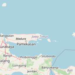
Map view of Baluran National Park

Use this park location map to pinpoint Baluran National Park in Indonesia, understand its exact geographic position, and read its mapped placement within the surrounding landscape more clearly.

Pigeon | © OpenStreetMap contributors

Location context for Baluran National Park

East JavaSitubondo Regency
Park atlas

Explore surrounding protected landscapes, compare savanna ecosystems, and trace regional park geography in East Java.

Explore Other National Parks and Protected Areas Near Baluran National Park, East Java

After exploring Baluran National Park's unique savanna, continue your discovery by browsing other protected areas in East Java and its adjacent regions. Compare varied landscapes, from volcanic terrain to coastal wetlands, and gain deeper insight into the regional spread of conservation efforts and park types.
National parkIndonesia
About 38 km away#1 closest

Southeast

West Bali National Park: An Indonesian National Park for Geographic and Landscape Exploration

Understand its mapped boundaries and regional natural terrain.

West Bali National Park is a significant protected landscape offering a focal point for geographic discovery within Indonesia. This national park provides context for the region's natural terrain and the spread of conservation lands. Explore its identity as a mapped protected area and understand its contribution to the broader atlas of Indonesian geography and protected landscapes, perfect for detailed landscape exploration.

Area
190.029 km²
Established
1941
IUCN
II
Visitors
58.7K annual
National parkEast Java
About 95 km away#2 closest

South

Alas Purwo National Park: A Protected Landscape within East Java's Geography

Mapped natural terrain and national park status in East Java.

Delve into the atlas-specific details of Alas Purwo National Park, a key protected area located in the East Java region of Indonesia. This page focuses on its identity as a national park, highlighting its geographic significance and the value of its mapped landscape for structured discovery. Understand the context of this protected land within the broader geography of East Java, contributing to a comprehensive overview of Indonesia's conservation territories.

Area
434.2 km²
Established
1992
IUCN
II
Visitors
14.7K annual
National parkEast Java
About 101 km away#3 closest

Southwest

Meru Betiri National Park: Mapped Protected Landscape in East Java

Discover the terrain and geography of this national park.

Meru Betiri National Park in East Java, Indonesia, offers a rich tapestry of mapped landscapes, from its distinctive sandy beaches and mangrove ecosystems along the southern coast to its interior volcanic highlands and tropical rainforests. This protected area is crucial for understanding the regional geography and the distribution of conservation lands across Java. Explore its topographic diversity and unique ecological settings that define this significant national park.

Area
580 km²
Established
1982
IUCN
II
Visitors
2.5K annual
National parkEast Java
About 138 km away#4 closest

West

Bromo Tengger Semeru National Park: East Java National Park and Protected Landscape Atlas

Mapped terrain and protected area boundaries in Indonesia's East Java

Delve into the protected geography of Bromo Tengger Semeru National Park, a designated national park situated in East Java. This resource offers detailed insights into the park's mapped boundaries and its role as a protected landscape within the dynamic region. Understand its place in the atlas of Indonesian natural areas and explore its unique terrain through structured geographic data.

Area
502.76 km²
Established
1982
IUCN
II
Visitors
61.7K annual
National parkIndonesia
About 235 km away#5 closest

East

Mount Rinjani National Park: Indonesia's Premier Volcanic Protected Landscape

Mapped geography and ecological transitions of a prominent Indonesian national park.

Mount Rinjani National Park is a key protected area in Indonesia, distinguished by its active stratovolcano and the striking Segara Anak crater lake. The park's landscape features steep volcanic slopes and diverse vegetation zones, from tropical rainforest to subalpine terrain. This detailed entry provides essential atlas context, focusing on the park's geographic boundaries, its unique volcanic geology, and its significance as a protected natural landscape within Indonesia's archipelagic geography.

Area
413 km²
Established
1990
IUCN
II
Relief
Mountain
National parkIndonesia
About 434 km away#6 closest

West

Gunung Merapi National Park: Indonesia's Protected National Park Landscape and Geography

Explore mapped boundaries and regional natural terrain within Indonesia.

Gunung Merapi National Park stands as a distinct protected area within the Indonesian atlas, offering insights into its specific landscape and geographic identity. This page provides a focused entry point for understanding the park's designation as a national park, detailing its mapped environmental features and regional context. Discover the characteristics that define Gunung Merapi National Park as a key component of Indonesia's protected lands, facilitating a structured approach to geographic exploration.

Area
64.1 km²
Established
2004
Relief
Mountain
Climate
Tropical
National parkIndonesia
About 435 km away#7 closest

West

Gunung Merbabu National Park: A Key Protected Landscape in Indonesia's Geography

Explore its mapped protected area boundaries and regional setting.

Gunung Merbabu National Park represents a distinct protected area entity within Indonesia's expansive geography. This page provides detailed information on the park's status as a national park, emphasizing its mapped territory and contribution to the understanding of protected landscapes. Discover its geographic context and how it fits into the broader atlas of Indonesian natural areas, offering a focused view for those interested in regional park geography and landscape exploration.

Area
57 km²
Established
2004
Relief
Mountain
Climate
Tropical
National parkCentral Java
About 492 km away#8 closest

Northwest

Karimunjawa National Park: A National Park in Central Java's Geographic Atlas

Mapped protected boundaries and landscape context.

Gain a structured atlas-based understanding of Karimunjawa National Park, a designated national park located in Central Java, Indonesia. This detailed view focuses on the park's geographic footprint and its significance as a protected landscape. Explore its mapped territory and regional context, contributing to a comprehensive overview of natural areas within the Central Java region.

Area
1,101.17 km²
Established
1999
IUCN
II
Relief
Upland

Common questions about visiting, size, designation, and location context for Baluran National Park

Baluran National Park FAQs for park facts, access, geography, and protected area context

Find quick answers about Baluran National Park, including protected-area facts, park geography, trail and visitor context, and how the park fits into its surrounding country and regional landscape.
MoriAtlas Explorer

Continue Your Protected Areas Search Across the Global Atlas

Deepen your exploration by continuing the structured search for national parks and protected areas worldwide. Utilize the comprehensive filtering capabilities to compare different conservation landscapes and refine your understanding of global park geography. Discover more about the distribution and characteristics of protected natural areas.

Global natural geography