

Mori Atlas logo
National parkBandingilo National Park

Explore the mapped boundaries and regional landscape of this national park in East Africa.

Bandingilo National Park: South Sudan's Protected Landscape Identity and Geographic Context

Bandingilo National Park represents a significant protected area within the diverse geography of South Sudan. As a national park, it offers unique insights into the country's natural landscapes and regional terrain. This page provides an atlas-centric view, detailing the park's geographic scope, its place within East Africa's broader context, and its importance for understanding protected land distribution and mapped natural features within South Sudan.

savanna ecosystemsbirdwatchinglarge mammal migrationcritical endangered specieswetland habitatstransboundary protected area

Bandingilo National Park

National park

Park overview

Structured park overview, official facts, and landscape profile for Bandingilo National Park

Bandingilo National Park park facts, protected area profile, and essential visitor context
Review the core facts for Bandingilo National Park, including designation, size, terrain, visitor scale, habitats, and operating context in one park-focused overview.

About Bandingilo National Park

Bandingilo National Park occupies a vital position in South Sudan's protected area network, representing a vast tract of relatively intact savanna and wetland ecosystems in the heart of Equatoria. The park's extensive size and strategic location along the White Nile floodplain make it a cornerstone of regional biodiversity conservation. Unlike many African protected areas that have suffered severe wildlife decline, Bandingilo maintained its animal populations through decades of regional conflict, likely because the area remained relatively inaccessible during the prolonged war years. The park forms part of a transboundary conservation landscape connecting South Sudan's southern parks with Gambella National Park in Ethiopia, creating one of the most significant wildlife corridors in eastern Africa. The seasonal dynamics of the park shape its ecological character, with wet season flooding transforming the grasslands into a vast wetland that supports enormous concentrations of wildlife, while dry season fires maintain the open habitats that allow migratory herds to move across the landscape.

Quick facts and research context for Bandingilo National Park

Bandingilo National Park spans approximately 10,000 square kilometres in South Sudan's Equatoria region, making it one of the largest protected areas in East Africa. The park sits near the White Nile river system and includes vast marshland ecosystems that flood during the wet season. It was established in 1992 and lies within the former boundaries of Central Equatoria and Eastern Equatoria states. The nearest major city is Juba, located roughly 150 kilometres to the southwest. The park's seasonal grasslands undergo a cycle of flooding and burning that helps maintain the open habitat conditions critical for migratory wildlife.

Park context

Deeper park guide and search-rich context for Bandingilo National Park

Bandingilo National Park history, landscape, wildlife, and travel context
Explore Bandingilo National Park through its history, landscape character, ecosystems, wildlife, conservation priorities, cultural context, and seasonal travel timing in a structured park guide built for atlas discovery and search intent.

Why Bandingilo National Park stands out

Bandingilo is best known for hosting the Great Nile Migration Landscape, the world's largest annual animal migration, where hundreds of thousands of antelopes including Bohor reedbuck, tiang, and white-eared kob traverse the savanna between South Sudan and Ethiopia. It is also renowned as a critical refuge for critically endangered species including the Nubian giraffe, Northeast African cheetah, and Northern lion. The park's status as an Important Bird Area with approximately 400 recorded bird species further establishes its significance as a biodiversity hotspot in the Nile basin.

Bandingilo National Park history and protected-area timeline

Bandingilo National Park was established in 1992 as part of South Sudan's developing protected area system during the later years of Sudanese civil conflict. Following South Sudan's independence in July 2011, the park gained renewed administrative attention, with an official headquarters opening ceremony led by the Central Equatoria Governor on 6 July 2011, just three days before formal independence. For years, the park was managed by the Ministry of Environment and Forestry and the Ministry of Wildlife Conservation and Tourism. In August 2022, African Parks, a prominent conservation NGO, signed a 10-year renewable agreement with the South Sudanese government to assume management responsibilities for Bandingilo and Boma National Parks, bringing professional conservation management to these protected areas for the first time.

Bandingilo National Park landscape and geographic character

The park encompasses a diverse landscape of wooded savanna, seasonal grasslands, and extensive marshlands situated along the White Nile river system. The terrain consists largely of flat to gently undulating plains that flood during the wet season, creating vast temporary wetlands that stretch northward toward Jonglei state. The mix of open grassland and woodland patches provides the heterogeneous habitat structure that supports both migratory wildlife and resident species. The park's location near the White Nile places it within the broader Nile basin ecosystem, with the river system influencing hydrology and vegetation patterns throughout the protected area.

Bandingilo National Park ecosystems, habitats, and plant life

Bandingilo supports a complex of seasonal habitats that cycling between flooding and burning creates the open grassland conditions essential for the park's ecological function. The wet season brings extensive flooding that transforms the savanna into a interconnected wetland system, while the subsequent dry season involves controlled burning that prevents woodland encroachment and maintains the grassland habitat that migratory species require. This dynamic ecological process has sustained the park's wildlife populations through millennia and continues to shape the ecosystem today. The combination of flood and fire maintains the successional conditions that support the extraordinary concentrations of grazers that define the Great Nile Migration.

Bandingilo National Park wildlife and species highlights

The park hosts an impressive array of wildlife, most notably the massive migratory herds of the Great Nile Migration Landscape. Antelope species including Bohor reedbuck, tiang, and white-eared kob form the backbone of this migration, moving in enormous herds between Bandingilo and neighboring protected areas. The park provides critical habitat for several critically endangered species: the Nubian giraffe, the Northeast African cheetah, and the Northern lion. Additional predators include African wild dog, caracal, and spotted hyena. The avifauna is equally remarkable, with an estimated 400 bird species present as of 2021, earning the park its Important Bird Area designation.

Bandingilo National Park conservation status and protection priorities

Bandingilo faces significant conservation challenges despite its ecological importance. While the 22-year war between Sudan and South Sudan did not appear to severely impact wildlife populations, the development of the new country introduced new threats. Conflict from approximately 2013 to 2020 further hampered conservation monitoring efforts, leaving the status of populations uncertain as of the early 2020s. A major concern is the park's location within a Total S.A. oil concession, potentially exposing it to hydrocarbon exploration and development pressure. The 2022 agreement with African Parks represents a critical opportunity to bring professional conservation management to the park, though implementing effective protection in this challenging context will require substantial resources and sustained commitment.

Bandingilo National Park cultural meaning and human context

The park occupies territory within the traditional lands of Equatoria's regional communities, though detailed information about indigenous relationships with the landscape is limited in available sources. The area's human population has historically engaged in pastoral and agricultural activities that interact with the seasonal wildlife migrations. The establishment of the protected area represents a modern conservation framework applied to a landscape with deep historical roots in regional human-ecological systems.

Top sights and standout views in Bandingilo National Park

The Great Nile Migration Landscape stands as the park's most extraordinary feature, with the annual movement of hundreds of thousands of antelopes representing the world's largest animal migration. The critically endangered Nubian giraffe, Northeast African cheetah, and Northern lion find crucial refuge within the park's boundaries. Over 400 bird species have been recorded, establishing the park as a major destination for avifauna conservation. The transboundary conservation landscape connecting Bandingilo with Boma and Gambella National Parks creates one of Africa's most significant wildlife corridors.

Best time to visit Bandingilo National Park

The park's seasons dramatically shape the visitor experience. The wet season brings flooding that creates spectacular wetland scenery and excellent wildlife viewing as animals concentrate around remaining water sources. The dry season reveals the park's vast savanna plains and offers the best opportunity to witness the massive animal migrations. However, visitors should note that South Sudan's infrastructure remains limited and access to remote parks like Bandingilo requires careful planning and local guidance.
Park location guide

Geography guide, regional context, and park location map for Bandingilo National Park

Bandingilo National Park park geography, regions, and map view in South Sudan
Understand where Bandingilo National Park sits in South Sudan through a broader geographic reading of the surrounding landscape, nearby location context, and its mapped position within the national park landscape.

How Bandingilo National Park fits into South Sudan

South Sudan is a landlocked sovereign state in East Africa, the most recent country to achieve independence (2011). It occupies an area of 644,329 km² and shares borders with six countries. The Nile River flows through the country, feeding the extensive Sudd wetland. With a population of approximately 12.7 million, South Sudan is linguistically diverse with English as its official language and numerous recognized national languages including Dinka, Nuer, and Bari.

Wider geography shaping Bandingilo National Park in South Sudan

South Sudan is located in East Africa, landlocked between six countries: Sudan to the north, Ethiopia to the east, Uganda to the south, Kenya to the southeast, the Democratic Republic of the Congo to the southwest, and the Central African Republic to the west. The terrain consists primarily of vast plains and plateaus, with diverse environments ranging from dry savannah to tropical savannah and inland floodplains. The Nile River system runs south to north through the country's center.

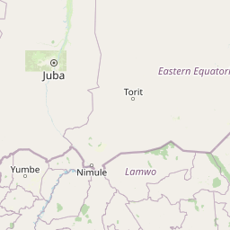
Map view of Bandingilo National Park

Use this park location map to pinpoint Bandingilo National Park in South Sudan, understand its exact geographic position, and read its mapped placement within the surrounding landscape more clearly.

Pigeon | © OpenStreetMap contributors

Location context for Bandingilo National Park

Equatoria
Park atlas

Map the protected areas and conservation landscapes linked to Bandingilo National Park's regional geography.

Explore Other National Parks and Protected Areas Near Bandingilo National Park
Continue your exploration beyond Bandingilo National Park to discover other national parks and protected areas across its surrounding regional geography. Compare different conservation landscapes and trace the extended transboundary ecosystems within East Africa, gaining valuable atlas-style insights into the broader Nile basin.
National parkSouth Sudan

Nimule National Park: South Sudan's National Park Geography and Protected Boundaries

Explore the terrain and mapped context of this protected landscape.

Nimule National Park represents a key protected area in South Sudan, providing essential geographic data for atlas exploration. This detail page focuses on the park's mapped boundaries, its role as a national park, and its contribution to the regional landscape context of East Africa. Understand the specific terrain and protected land identity that defines this important natural area within the country.

Area
410 km²
Established
1954
IUCN
II
Scope
Terrestrial
National parkSouth Sudan

Boma National Park: Protected Landscape in South Sudan's East African Geography

Explore mapped boundaries and regional terrain context.

Boma National Park represents a vital protected landscape within South Sudan. As a national park, it contributes significantly to the geographic understanding of conservation areas in East Africa. Its distinct location and mapped outlines provide essential context for those exploring the regional atlas, highlighting its importance in understanding South Sudan's natural terrain and protected area network.

Area
22,800 km²
Established
1977
IUCN
II
Relief
Lowland
National parkSouth Sudan

Lantoto National Park: A Protected National Park in South Sudan's Geography

Explore its mapped boundaries and regional landscape context.

Lantoto National Park represents a critical protected area within the vast geography of South Sudan. As a designated national park, it serves as a focal point for understanding landscape features and conservation efforts within East Africa. This atlas-centric view highlights its mapped presence and the broader regional context it occupies, offering a structured approach to exploring South Sudan's natural terrain and protected lands.

Area
760 km²
Established
1986
IUCN
II
Relief
Mountain
National parkUganda

Murchison Falls National Park: Uganda's Largest Protected Landscape with Dramatic Nile Gorge

Explore mapped boundaries and diverse savanna terrain.

Murchison Falls National Park represents a significant protected landscape in Uganda, renowned for the powerful cascade of the Victoria Nile through a narrow gorge. This expansive national park encompasses varied terrain, from savanna woodlands to riparian forests, offering a rich geographic context. Understanding its mapped distribution within the region is key to appreciating its conservation importance and unique natural features, providing a compelling atlas-style entry point for exploration.

Area
3,893 km²
Established
1952
IUCN
II
Relief
Lowland
National parkDemocratic Republic of the Congo

Garamba National Park: Protected Landscape Atlas and Geographic Context in DRC

Explore Mapped Boundaries of Africa's Historic Savanna Sanctuary

Garamba National Park is a foundational protected area within the Democratic Republic of the Congo, spanning nearly 5,200 square kilometers of distinctive tropical savanna. Established in 1938, this national park is recognized globally as a UNESCO World Heritage Site due to its exceptional biodiversity and role as a critical habitat. The park's landscape is characterized by rolling grasslands, scattered woodlands, and a unique ecological position that supports a rich variety of wildlife, including significant populations of elephants and the DRC's last giraffes. Exploring Garamba National Park through MoriAtlas provides insight into its mapped boundaries, regional geography, and its status as a vital sanctuary for endangered species.

Area
5,200 km²
Established
1938
IUCN
II
Relief
Lowland
National parkEthiopia

Omo National Park: Ethiopia's Remote Protected Landscape with Rich Wildlife Spectacles

Mapped boundaries, savannah plains, and Maji Mountains terrain.

Omo National Park is a remote protected area in Ethiopia renowned for its expansive savannah, riverine woodlands, and remarkable wildlife concentrations. Covering over 4,000 square kilometers, this national park presents a landscape of sweeping plains, the vital Omo River corridor, and the dramatic Maji Mountains. The park's protected status safeguards exceptional populations of large mammals, offering a glimpse into an untamed African wilderness. Explore the mapped geography and the unique ecological zones that contribute to its significant conservation value.

Area
4,068 km²
Established
1980
IUCN
II
Relief
Mixed relief
National parkSouth Ethiopia Regional State

Mago National Park: Protected Savanna and Riverine Ecosystems in South Ethiopia

Discover the unique landscapes and wildlife habitats mapped within this national park.

Mago National Park stands as a critical protected landscape within the South Ethiopia Regional State, characterized by its significant riverine forests, acacia savanna, and wetland environments along the Mago and Omo rivers. This national park is integral for understanding the distribution of wildlife and the geographic context of Ethiopia's natural heritage. Its mapped terrain offers insights into a landscape that supports both diverse ecosystems and unique cultural traditions, making it a vital component of the country's conservation network.

Area
2,220 km²
Established
1979
IUCN
II
Relief
Mixed relief
National parkSouth Sudan

Southern National Park National Park: An Extensive Protected Landscape in South Sudan's Nile Basin

Mapped floodplains, savanna woodlands, and large mammal conservation.

Southern National Park stands as a significant protected area within South Sudan, celebrated for its immense scale and rich ecological tapestry. This national park features a complex mosaic of savanna woodlands, extensive seasonal floodplains carved by the Gel and Ibba rivers, and gallery forests lining river corridors. Its designation as a protected landscape highlights its importance for conserving large mammal populations and preserving the unique wetland ecosystems characteristic of the Nile basin's western reaches, offering a prime focus for geographic and atlas exploration.

Area
23,000 km²
Established
1939
IUCN
II
Relief
Lowland

Common questions about visiting, size, designation, and location context for Bandingilo National Park

Bandingilo National Park FAQs for park facts, access, geography, and protected area context
Find quick answers about Bandingilo National Park, including protected-area facts, park geography, trail and visitor context, and how the park fits into its surrounding country and regional landscape.
MoriAtlas Explorer

Continue Your Protected Areas Search Across the Global Atlas

Deepen your exploration by continuing the structured search for national parks and protected areas worldwide. Utilize the comprehensive filtering capabilities to compare different conservation landscapes and refine your understanding of global park geography. Discover more about the distribution and characteristics of protected natural areas.

Global natural geography


