


Mori Atlas logo
Protected areaBarren Island

Tracing the geological boundaries and active volcanic terrain of an uninhabited Indian island

Barren Island Protected Area: Analyzing the Volcanic Geography and Andaman Sea Marine Landscape

Barren Island stands as the singular confirmed active stratovolcano in the Indian subcontinent, rising from the depths of the Andaman Sea within the Andaman and Nicobar Islands. This protected area features a distinct central scoria cone, an encircling caldera, and dramatic basaltic slopes that transition into diverse marine habitats. The surrounding waters are characterized by steep submarine volcanic ridges, vibrant coral gardens, and clear visibility that define the site's unique regional geography.

active volcanostratovolcanovolcanic islandAndaman Seauninhabited islandwildlife sanctuary
An artistic digital illustration of a colorful mountain canyon with a waterfall cascading down, surrounded by stylized pine trees and a river in the foreground.

Barren Island

Protected area

Park overview

Structured park overview, official facts, and landscape profile for Barren Island

Barren Island park facts, protected area profile, and essential visitor context

Review the core facts for Barren Island, including designation, size, terrain, visitor scale, habitats, and operating context in one park-focused overview.

About Barren Island

Barren Island is an uninhabited volcanic island in the Andaman Sea and one of the most unusual natural landmarks in India. Geologically, it is the subaerial expression of a subduction-related stratovolcano that rises from oceanic crust roughly 106 million years old, while the oldest exposed lava flows on the island itself date back about 1.6 million years. Administratively, the island belongs to the North and Middle Andaman district of the Union Territory of Andaman and Nicobar Islands and is formally designated as a wildlife sanctuary.

Volcanism here is driven by the subduction of the Indian Plate beneath the Burma plate, producing mostly mafic magmas in a tholeiitic series, ranging from low-K basalts to basaltic andesites, with minor andesites erupted in prehistoric times. Eruptions over the past two centuries have been relatively small on the Volcanic Explosivity Index and follow a broadly Strombolian to Hawaiian style, with lava fountaining, short ‘a‘ā flows, and modest ash plumes from a central scoria cone set within a caldera. Phreatomagmatic rocks at the base of the volcanic edifice record earlier episodes in which rising magma interacted with seawater.

Despite repeated eruptions, the island is not entirely barren. Its slopes carry thick vegetation sustained in part by fresh-water springs, and these pockets of greenery support a small but persistent community of wildlife, including feral goats, rats, flying foxes, and several bird species. The combination of hostile terrain, intermittent volcanic violence, and the habitats that rebound between eruptions makes Barren Island a remarkable natural laboratory of disturbance and recovery.

Quick facts and research context for Barren Island

Barren Island sits in the Andaman Sea about 138 kilometers northeast of Port Blair, within the North and Middle Andaman administrative district of India's Union Territory of Andaman and Nicobar Islands. It is the only island in the East Volcano sub-group of the archipelago to host an active vent, and it is classified as a stratovolcano with associated pyroclastic cones.

The island covers roughly 8 square kilometers and rises to about 354 meters above sea level at the summit of its central scoria cone. It is uninhabited by humans and is formally protected as the Barren Island Wild Life Sanctuary. Recorded eruptions span from 1787 to the present day, with major episodes in 1787, 1795, 1803 to 1804, 1852, 1991 to 1995, 2005 to 2007, 2017 to 2019, and renewed activity beginning in 2022.

Protection and recognition

Examine the official protection framework and international recognition data for Barren Island.

Barren Island Protection Status and Documented Conservation Scope

Barren Island maintains a mixed protection scope governed by structured conservation boundaries and administrative frameworks. Documented records outline the established designation status and international recognition sources associated with the protected area.

Protection details

Protection scope
Mixed
Transboundary protection
No
Park context

Deeper park guide and search-rich context for Barren Island

Barren Island history, landscape, wildlife, and travel context

Explore Barren Island through its history, landscape character, ecosystems, wildlife, conservation priorities, cultural context, and seasonal travel timing in a structured park guide built for atlas discovery and search intent.

Why Barren Island stands out

Barren Island is best known as the only confirmed active volcano in the Indian subcontinent, and the only currently active vent along the chain of volcanoes running northward from Sumatra toward Myanmar. Its eruptions are typically Strombolian to Hawaiian in style, producing short bursts of lava fountaining, small ash plumes, and channelized flows from a central scoria cone inside a caldera. The island is just as widely recognized underwater. The surrounding Andaman Sea waters are considered a world-class scuba diving destination because of exceptionally clear visibility, frequent encounters with manta rays, distinctive basaltic lava topography, and fast-growing coral gardens that colonize freshly hardened lava. Together, the active summit, the dramatic submarine volcanic landscape, and the recovery of life between eruptions give the island its singular identity.
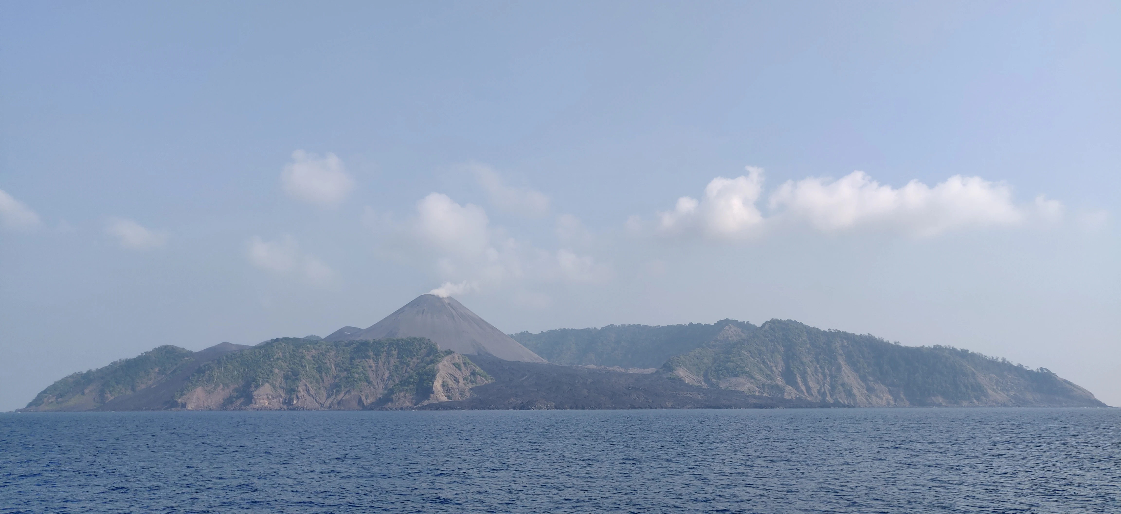
A wide shot of a volcanic island rising from the sea, with a conical peak emitting a faint plume of smoke and rugged, partially vegetated slopes.
A view of the active volcanic landscape of Barren Island from the Andaman Sea.

Barren Island history and protected-area timeline

Scientific work suggests that the oldest exposed lava flows on Barren Island were erupted around 1.6 million years ago, placing the volcano well within the Quaternary history of the Andaman Sea. The first eruption recorded by humans took place in 1787, since when more than a dozen additional eruptions have been documented, including events in 1789, 1795, 1803 to 1804, and 1852.

After roughly one and a half centuries of relative quiet, the volcano reawakened in 1991 in an eruption that lasted about six months and caused significant ecological damage. A Geological Survey of India expedition in April 1993 found that the eruption had reduced both the diversity and abundance of the island's birds, with only six of sixteen previously recorded species detected; the pied imperial pigeon was the most numerous survivor. The same visit recorded a single rat species and around fifty insect species across eight orders, and confirmed that the volcano was still degassing. Further eruptions were recorded in 1994 to 1995 and from 2005 to 2007, the latter activity being linked to the catastrophic 2004 Indian Ocean earthquake.

Activity resumed in 2017, when scientists from the National Institute of Oceanography witnessed short episodic eruptions with ash plumes during the day and red lava fountains after dusk. The volcano entered a renewed phase in January 2022 and has since produced relatively frequent ash plumes, with explosive activity and substantial plumes continuing into 2025. A lighthouse established in 1993 was destroyed by subsequent eruptions.

Barren Island landscape and geographic character

Barren Island is essentially the summit of a stratovolcano that rises from the floor of the Andaman Sea to a peak of about 354 meters above sea level. The island is roughly oval in plan, measuring about 3.4 kilometers in length and 3.1 kilometers in width, with around 12 kilometers of coastline encircling a central caldera. Inside this caldera sits a fresh-looking scoria cone, which is the main vent for modern eruptions. Pyroclastic cones dot the broader edifice, and the lower slopes preserve evidence of phreatomagmatic eruptions in which rising magma met seawater.

True to its name, much of the rim and upper volcano is barren, an expanse of dark volcanic rock, ash, and solidified lava flows with little soil development. Lower slopes and sheltered valleys, however, support surprisingly thick vegetation, held together by fresh-water springs that emerge from the volcanic substrate. Successive eruptions have repeatedly scoured and rebuilt these landscapes, creating a patchwork of fresh black flows alongside older, partly revegetated terrain. Below the waterline, the island's flanks continue as a dramatic volcanic terrain of basalt ridges, lava ridges, and ash-covered substrate.
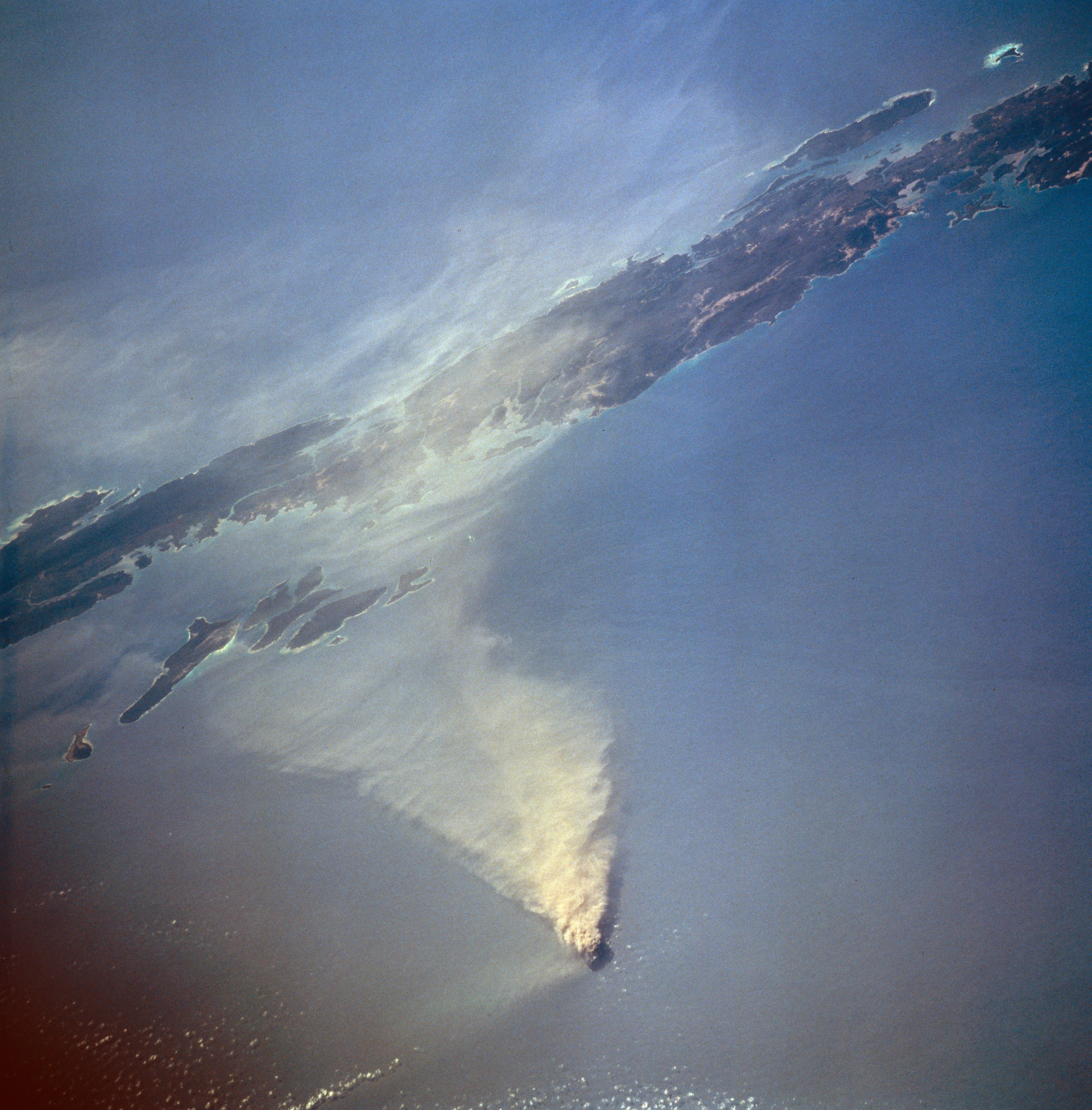
High angle aerial satellite view of a small volcanic island in the ocean with a large plume of smoke and ash extending across the water surface.
An aerial satellite view of a volcanic plume rising from Barren Island in the Andaman Sea, captured on March 14, 1995.

Barren Island ecosystems, habitats, and plant life

Despite its volatile geology, Barren Island supports a mosaic of habitats that recover and retreat with each volcanic episode. The barren upper slopes and inner caldera give way to broader vegetated zones on the mid and lower flanks, where soils have had time to develop between eruptions and where fresh-water springs allow plant communities to persist. This contrast between bare volcanic ground and green cover is one of the defining visual and ecological signatures of the island.

Formally, the whole island is protected as the Barren Island Wild Life Sanctuary, reflecting its value as a refuge for species that have managed to colonize and survive in an actively volcanic environment. Repeated eruptions reset large parts of this ecosystem, but the springs and vegetated flanks continue to act as refugia, allowing plants and animals to recolonize between eruptive phases.

Barren Island wildlife and species highlights

The island's wildlife is shaped both by the harshness of its volcanic environment and by the recurring disturbance of eruptions. The 1991 eruption dramatically reduced bird diversity, but several species have persisted or recolonized since then; the pied imperial pigeon has been recorded as one of the more abundant birds on the island, alongside other pigeon species observed in later surveys.

Mammals on the island are few but distinctive. Feral goats roam the vegetated slopes, sustained by fresh-water springs and thick vegetation, even though their presence on an active volcano has long surprised visiting geologists. Historical accounts note that these goats were introduced by British sailors from a steamer leaving Port Blair in 1891. Rodents, including the common rat, are also present, as are flying foxes, the large fruit bats of the genus Pteropus, which roost in the island's trees. Insect life recorded after the 1991 eruption included around fifty-one species spread across eight orders, underlining how quickly invertebrate communities re-establish themselves between eruptions.

Barren Island conservation status and protection priorities

Barren Island is designated as a wildlife sanctuary under Indian protected-area legislation, giving the entire island formal protection despite the absence of any permanent human population. This recognition reflects both the unusual scientific value of an active volcanic island and the importance of safeguarding the fragile assemblages of plants and animals that survive there.

Conservation significance lies less in species richness measured against mainland parks and more in the role of the island as a natural laboratory for studying how life recovers from extreme disturbance. Each eruption resets parts of the ecosystem, while fresh-water springs and vegetated patches act as refugia, allowing recolonization by birds, mammals, and invertebrates. Its protected status also helps preserve a rare example of a subduction-driven island volcano within Indian territory.

Barren Island cultural meaning and human context

Because Barren Island has no permanent population, its human story is one of passing contact rather than long-standing settlement. The known history of human interaction is largely limited to sailors who introduced feral goats from a steamer leaving Port Blair in 1891, and to occasional scientific and administrative visits by Indian geologists, ecologists, and oceanographers documenting eruptions and their ecological impact.

The island has nonetheless acquired a strong cultural and sporting significance in another arena: scuba diving. The surrounding waters are widely promoted as one of the world's top dive destinations, and Barren Island has become a fixture of the Andaman Islands' adventure-tourism identity, drawn by pilots and divers rather than by residents.

Top sights and standout views in Barren Island

Barren Island is the only confirmed active volcano in the Indian subcontinent, and its central scoria cone inside a caldera produces Strombolian to Hawaiian eruptions of lava fountaining and modest ash plumes. The island's ancient oceanic-crust setting, dating back more than 100 million years, and its 1.6-million-year volcanic history set it apart from almost any other protected landscape in India.

Underwater, the surrounding Andaman Sea offers exceptional visibility, manta rays, and vibrant coral gardens growing on fresh basaltic lava flows, making the island a destination for divers interested in both volcanic geology and marine life. On land, the patchwork of barren volcanic rock, thickly vegetated slopes, fresh-water springs, feral goats, and recovering bird and bat populations gives Barren Island a unique profile as a place where destruction and renewal are part of the everyday landscape.

Best time to visit Barren Island

Like most remote volcanic sites, Barren Island is influenced by weather and sea conditions in the Andaman Sea. The wider Andaman archipelago generally sees more stable conditions outside the main monsoon months, when calmer seas favor both dive operations and the visibility that makes the surrounding waters famous. Cooler, drier periods also tend to make any approach by boat more comfortable and to provide clearer views of the island's profile.

Because the volcano has been in an almost continuous state of eruption in recent years, and because authorities may restrict access during periods of heightened volcanic activity, any visit ultimately depends on current safety conditions in addition to season. Divers and visitors typically plan around weather windows and check current volcanic advisories before arranging trips from Port Blair or Swaraj Island.
Monthly climate preview

Long-term monthly temperature averages and precipitation patterns for Barren Island

Barren Island Climate Normals: Annual Temperature and Precipitation Rhythm

Representative coordinates record sustained monthly temperatures between 26 and 30 degrees Celsius alongside distinct wet and dry precipitation cycles throughout the year. Reviewing the complete twelve-month climatology profile reveals detailed variations in baseline temperature and rainfall distribution across Barren Island.
Annual mean28 °C
27 °C29 °C
Jan27°
Feb27°
Mar27°
Apr29°
May29°
Jun29°
Jul28°
Aug28°
Sep28°
Oct28°
Nov28°
Dec27°
Warmest month
May

29.2 °C

Coolest month
January

26.6 °C

Wettest month
July

14.7 mm/day

Driest month
February

0.4 mm/day

Park location guide

Geography guide, regional context, and park location map for Barren Island

Barren Island park geography, regions, and map view in India

Understand where Barren Island sits in India through a broader geographic reading of the surrounding landscape, nearby location context, and its mapped position within the national park landscape.

How Barren Island fits into India

India is a South Asian country bordered by the Indian Ocean, Arabian Sea, and Bay of Bengal. It shares land borders with Pakistan, China, Nepal, Bhutan, Bangladesh, and Myanmar. The country has a population of over 1.4 billion people and operates as a federal parliamentary republic with its capital in New Delhi.

Wider geography shaping Barren Island in India

India occupies the Indian subcontinent in South Asia, bordered by the Arabian Sea to the southwest, the Bay of Bengal to the southeast, and the Indian Ocean to the south. It shares land borders with Pakistan to the west, China, Nepal, and Bhutan to the north, and Bangladesh and Myanmar to the east. The territory also includes the Andaman and Nicobar Islands in the Indian Ocean.

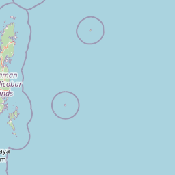
Map view of Barren Island

Use this park location map to pinpoint Barren Island in India, understand its exact geographic position, and read its mapped placement within the surrounding landscape more clearly.

Pigeon | © OpenStreetMap contributors

Location context for Barren Island

Andaman and Nicobar Islands

Explore photographic records of stratovolcano terrain, dark lava flows, and marine habitats.

Barren Island Photos and Volcanic Landscapes: Visual Guide to Scenery

Visual documentation captures the rugged topography, dark ash slopes, and active summit features that define the reserve. Examining these photographic records helps visitors understand the unique geological character and marine environments surrounding the island.

A wide shot of a volcanic island rising from the sea, with a conical peak emitting a faint plume of smoke and rugged, partially vegetated slopes.

An aerial satellite image of Barren Island in the Andaman Sea showing the circular volcanic island with a central crater emitting a plume of smoke.

High angle aerial satellite view of a small volcanic island in the ocean with a large plume of smoke and ash extending across the water surface.

Park atlas

Continue comparing island reserves, marine habitats, and surrounding volcanic terrain.

Explore Other Parks Near Barren Island and Protected Areas in the Region

Compare Barren Island with other protected areas across the surrounding Andaman Sea region to analyze regional park geography and marine habitats. Extending the exploration provides deeper context on isolated island ecosystems and volcanic landscapes.
National parkAndaman and Nicobar Islands
About 86 km away#1 closest

West

North Button Island National Park: Protected Landscape and Mapped Geographic Identity

Explore the mapped boundaries and regional natural terrain.

Gain a clear understanding of North Button Island National Park as a distinct protected landscape within the Andaman and Nicobar Islands region. This entry offers detailed geographic context, focusing on the park's mapped boundaries and its role within the archipelago's natural terrain. It serves as a foundational element for understanding this Indian National Park's place in a broader atlas of conservation areas.

Area
114 km²
Established
1979
National parkAndaman and Nicobar
About 91 km away#2 closest

West

Middle Button Island National Park: National Park within Andaman and Nicobar's Geography

Explore protected landscape context and mapped park boundaries.

Middle Button Island National Park represents a significant protected natural landscape, offering users a focused entry point for geographic discovery. As a designated national park, it contributes distinct mapped boundaries and terrain characteristics to the Andaman and Nicobar region's atlas data. Understanding its specific identity helps contextualize the broader protected-area network and regional geography. This page details the park's role as a conserved territory, vital for those seeking structured landscape and geography information.

Area
64 km²
Established
1979
Relief
Lowland
Climate
Tropical
National parkAndaman and Nicobar Islands
About 92 km away#3 closest

West

South Button Island National Park: Mapped Boundaries and Regional Protected Landscape

Key National Park in the Andaman and Nicobar Islands

South Button Island National Park is a protected natural area offering critical insight into the geography of the Andaman and Nicobar Islands. This detailed view focuses on its mapped boundaries and its significance as a national park within this Indian archipelago. Understanding its position within the regional geography provides essential context for exploring protected lands and natural landscapes across the Andaman and Nicobar Islands.

Area
5 km²
Relief
Lowland
Climate
Tropical
Access
Moderate access
Wildlife reserveAndaman and Nicobar Islands
About 108 km away#4 closest

Northwest

Cuthbert Bay Wildlife Sanctuary: Coastal Habitat and Sea Turtle Nesting Ground

Eastern Middle Andaman protected coastal geography

Cuthbert Bay Wildlife Sanctuary covers 5.8 square kilometres of critical coastal terrain along the eastern Middle Andaman coastline. Renowned for its concentration of sea turtle nesting beaches, the reserve supports diverse coastal ecosystems ranging from open sand to inland forest patches. It serves as a compact but vital ecological anchor within the broader landscape of the Andaman and Nicobar Islands.

Area
5.8 km²
Established
1997
IUCN
IV
Scope
Terrestrial
National parkAndaman and Nicobar Islands
About 125 km away#5 closest

Southwest

Mount Harriet National Park: National Park Mapping and Protected Landscape Identity

Explore its endemic biodiversity and mountain forest terrain.

Mount Harriet National Park provides a deep dive into a unique protected landscape, offering detailed insights into its geography, terrain, and ecological significance within the Andaman and Nicobar Islands. As a national park, it showcases a remarkable combination of mountainous forest ecosystems and coastal environments, serving as a vital habitat for numerous endemic species. Understanding its mapped boundaries and regional geographic context reveals why this protected area is a key point of interest for atlas-based natural landscape exploration.

Area
46.62 km²
Established
1979
IUCN
II
Relief
Mountain
National parkIndia
About 130 km away#6 closest

Northwest

Saddle Peak National Park: Mapped Boundaries and National Park Geography

Explore India's protected landscapes and regional terrain.

Saddle Peak National Park stands as a distinct national park within India, offering rich opportunities for geographic exploration. Examine its mapped boundaries and understand its specific landscape characteristics. This entry serves as a vital point for comprehending the park's protected status and its contribution to the atlas of India's natural terrain.

Area
32.54 km²
Established
1979
IUCN
II
Relief
Mountain
Wildlife reserveAndaman and Nicobar Islands
About 132 km away#7 closest

West

Flat Island Wildlife Sanctuary: Protected Island Geography in the Andaman and Nicobar Islands

Coastal wildlife reserve and isolated island terrain

Flat Island Wildlife Sanctuary stands as a distinct, low lying protected area within the Andaman and Nicobar Islands. Its compact oval shape and shoreline focused landscape provide a clear example of the archipelago's small scale, uninhabited marine reserves. This protected island serves as a vital geographic marker for those mapping the diverse coastal habitats found across the Bay of Bengal.

Area
2.48 km²
Relief
Lowland
Climate
Tropical
Access
Remote access
Wildlife reserveAndaman and Nicobar Islands
About 132 km away#8 closest

Northwest

Bamboo Island Wildlife Sanctuary: Mapping Coastal Protected Landscapes in the Andaman Archipelago

Coastal habitat, coral reefs, and littoral forest geography

Bamboo Island Wildlife Sanctuary represents a crucial protected area within the Andaman and Nicobar Islands, focusing on the interface between unique littoral bamboo thickets and surrounding marine reef environments. This reserve highlights the role of small island geography in conserving coastal stability and sensitive marine habitats within the Indian Bay of Bengal territory.

Area
0.05 km²
Established
1987
IUCN
IV
Relief
Lowland

Common questions about visiting, size, designation, and location context for Barren Island

Barren Island FAQs for park facts, access, geography, and protected area context

Find quick answers about Barren Island, including protected-area facts, park geography, trail and visitor context, and how the park fits into its surrounding country and regional landscape.
MoriAtlas Explorer

Continue Your Protected Areas Search Across the Global Atlas

Deepen your exploration by continuing the structured search for national parks and protected areas worldwide. Utilize the comprehensive filtering capabilities to compare different conservation landscapes and refine your understanding of global park geography. Discover more about the distribution and characteristics of protected natural areas.

Global natural geography