Mori Atlas logo
National parkBatang Gadis National Park

Discover the mapped boundaries and landscape context of this national park.

Batang Gadis National Park: Protected Area Identity and North Sumatra Geography

(Taman Nasional Batang Gadis)

Batang Gadis National Park represents a significant protected natural area within North Sumatra Province, Indonesia. This entry focuses on its identity as a national park, offering insights into its geographic placement and the surrounding regional context. Explore the mapped outlines and discover the landscape character that defines Batang Gadis National Park, contributing to a richer atlas understanding of Indonesia's protected lands.

National ParkIndonesiaNorth SumatraSumatran Tiger HabitatMontane ForestBiodiversity Corridor

Batang Gadis National Park

National park

Park overview

Structured park overview, official facts, and landscape profile for Batang Gadis National Park

Batang Gadis National Park park facts, protected area profile, and essential visitor context

Review the core facts for Batang Gadis National Park, including designation, size, terrain, visitor scale, habitats, and operating context in one park-focused overview.

About Batang Gadis National Park

Batang Gadis National Park occupies a strategically important position in Sumatra's conservation landscape, forming a vital link in the chain of protected areas that run along the western spine of the island through the Bukit Barisan mountain range. The park's location in North Sumatra places it at the heart of a region that has experienced significant forest loss and degradation over recent decades, making its protected forests increasingly valuable as refugia for wildlife and as watershed protection zones. The park's establishment in 2004 represented the culmination of a proposal submitted by local government authorities in 2003, building upon decades of informal protection that dated back to the Dutch colonial administration which first designated portions of the area as protected forest in 1921. The park is administered by the Ministry of Environment and Forestry through the BKSDA (Balai Konservasi Sumber Daya Alam) office in North Sumatra, with management responsibilities encompassing biodiversity conservation, watershed protection, and sustainable use zones within its boundaries. The park encompasses portions of 68 villages across 13 sub-districts within Mandailing Natal Regency, creating both opportunities and challenges for community-based conservation approaches that integrate local livelihoods with environmental protection objectives.

Quick facts and research context for Batang Gadis National Park

Batang Gadis National Park is located in Mandailing Natal Regency, North Sumatra Province, Indonesia, with the nearest urban centers being Panyabungan and Padang Sidempuan. The park spans elevations from 300 to 2,145 meters, encompassing steep mountainous and hilly terrain with average slopes exceeding 40 percent. It was formally established in 2004 under Forestry Minister Decree No. 126/Kpts-II/2004, though portions of its forest were protected since the Dutch colonial period beginning in 1921. The park contains approximately 47 mammal species, 247 bird species, and 240 vascular plant species, with notable conservation targets including the Sumatran tiger, Malayan tapir, sun bear, siamang, and various endemic bird species. The park was reduced in size from its original 108,000 hectares to approximately 72,800 hectares following a 2012 boundary revision, with released areas redesignated as protected forest and limited production forest.

Protection and recognition

Exploring the official terrestrial management framework and global designation record

Batang Gadis National Park Documented Protection Status and Designations

Terrestrial conservation records outline the official boundary framework and designation status for Batang Gadis National Park. Tracking documented credentials and international registry listings provides essential geographic context for understanding regional protection levels.

Protection details

Protection scope
Terrestrial
Transboundary protection
No
Park context

Deeper park guide and search-rich context for Batang Gadis National Park

Batang Gadis National Park history, landscape, wildlife, and travel context

Explore Batang Gadis National Park through its history, landscape character, ecosystems, wildlife, conservation priorities, cultural context, and seasonal travel timing in a structured park guide built for atlas discovery and search intent.

Why Batang Gadis National Park stands out

Batang Gadis National Park is best known for its role as a critical habitat for the critically endangered Sumatran tiger, with population estimates ranging from 23 to 76 individuals representing roughly 20 percent of the remaining wild population. The park protects substantial tracts of montane and lowland forest within the Bukit Barisan mountain range, making it a key biodiversity stronghold in northern Sumatra. Its diverse elevation range creates a complex gradient of ecosystems from tropical lowland rainforest through to montane forest zones, supporting unusual ecological diversity within a relatively compact area. The park also contains significant populations of other threatened felids including the clouded leopard, Asian golden cat, and leopard cat, as well as the Malayan tapir, sun bear, and the distinctive siamang Gibbons that inhabit its forest canopies. The presence of rare flowering plants including Rafflesia and pitcher plants adds to the park's botanical significance.

Batang Gadis National Park history and protected-area timeline

The formal protection history of Batang Gadis National Park traces to the Dutch colonial period when portions of the forest were designated as protected areas beginning in 1921, establishing early recognition of the region's ecological value. These early protections established Register forest designations that remained in place through subsequent Indonesian administration, creating a foundation of legal protection that would eventually support national park designation. The proposal to establish a national park was submitted by local government authorities in 2003, reflecting growing recognition of the need for comprehensive conservation of the region's biodiversity and watershed functions. The national park was formally declared in 2004 under Forestry Minister Decree No. 126/Kpts-II/2004, initially covering approximately 108,000 hectares. In 2012, following a legal challenge by a mining company, the park's boundaries were revised through Ministry of Forestry Decree No. 121, reducing its extent to approximately 72,803.75 hectares as land was reclassified to protected forest and limited production forest categories. The park's establishment was supported by various non-governmental organizations including BITRA Indonesia, Conservation International Indonesia, Walhi North Sumatra, PUSAKA Indonesia, Yayasan Leuser Lestari, and Yayasan Samudra, reflecting collaborative conservation efforts spanning government, civil society, and local communities.

Batang Gadis National Park landscape and geographic character

The landscape of Batang Gadis National Park is characterized by dramatic topography ranging from gentle valley floors at lower elevations to steep mountainous terrain approaching the summit of Gunung Sorik Marapi. The park sits within the Bukit Barisan mountain range, the volcanic backbone of Sumatra, with elevations varying from 300 meters to 2,145 meters at the park's highest point. The terrain is predominantly hilly to mountainous with average slopes exceeding 40 percent, creating challenging access conditions that have historically limited human encroachment while also presenting management challenges for trail development and monitoring. The park contains numerous valleys and river corridors formed by the Batang Gadis River and its tributaries, which have carved deep channels through the mountainous terrain creating riparian habitats and wetlands at various elevations. The geological setting within an active volcanic zone contributes to soil conditions that support luxuriant vegetation growth, while also creating inherently unstable conditions on steep slopes. The park encompasses distinct ecological zones including lowland tropical rainforest below 1,000 meters, transitioning through hill forest to montane forest above 1,000 meters, with additional variation created by the presence of highland wetlands and swamp areas.

Batang Gadis National Park ecosystems, habitats, and plant life

The ecological character of Batang Gadis National Park is defined by its complex gradient of forest ecosystems spanning from tropical lowland rainforest through to montane forest zones, creating remarkably diverse habitat conditions within a single protected area. The park's forests are classified into two primary formations: the Air Bangis-Singkil Formation in the western Bukit Barisan at elevations between 300 and 1,000 meters, and montane ecosystems in the main Bukit Barisan range between 1,000 and 1,800 meters. Approximately half of the park's area consists of lowland forest within the Air Bangis-Singkil Formation, representing some of the most species-rich habitat types in Southeast Asia. Research has documented exceptional plant density in certain areas, with sampling of 200 square meters revealing 242 vascular plant species representing approximately one percent of all flora in Indonesia. Common understory species include Heptapleurum aromaticum and the fern Diplazium proliferum, with distinctive patterns of dominance varying according to elevation and disturbance levels. The park's wetlands and swamp areas add further ecological diversity, providing important habitat for water-dependent species and contributing to watershed hydrology throughout the mountain catchments.

Batang Gadis National Park wildlife and species highlights

Batang Gadis National Park supports remarkable mammalian diversity with at least 47 species documented, including several species of significant conservation concern. The park provides critical habitat for the Sumatran tiger, with population estimates suggesting 23 to 76 individuals may be present, representing a substantial portion of the remaining wild population on the island. Other notable felids include the clouded leopard, Asian golden cat, and leopard cat, all of which have been recorded within the park through camera trap surveys and direct observations. The mammalian community includes the Malayan tapir, a distinctive browsing mammal characteristic of Southeast Asian forests, as well as the sun bear, the smallest bear species in the world. Primate species present include siamang gibbons, various macaques, and langurs, while the park also supports populations of sambar deer, Indian muntjac, and the unusual Java mouse-deer. The bird community is equally diverse with 247 species recorded, including 13 endemic species such as Salvadori's pheasant and Schneider's pitta. Approximately 47 of these bird species are legally protected, with seven considered threatened with extinction and an additional twelve classified as near-threatened.

Batang Gadis National Park conservation status and protection priorities

Batang Gadis National Park serves as a critical node in Sumatra's protected area network, contributing to the broader Northern Sumatra biodiversity conservation corridor that connects multiple protected areas from the park northwards to Gunung Leuser National Park. This corridor approach recognizes that isolated protected areas alone cannot sustain viable populations of wide-ranging species like the Sumatran tiger, requiring connected landscapes that allow for gene flow and demographic interchange between subpopulations. The park's conservation significance is enhanced by its elevation range, which captures diverse habitat types within a relatively compact area, increasing its value for biodiversity preservation. However, the park faces significant conservation challenges including poaching pressure on wildlife populations and encroachment from mining activities, with an Australian company holding a concession of approximately 200,000 hectares that overlaps with portions of the national park boundary. Illegal logging and forest conversion represent ongoing threats, with historical rates of forest loss in North Sumatra province reaching approximately 76,000 hectares annually during the 1985-1998 period. Local communities maintain traditional conservation practices through designated forest protection areas known as lubuk dilarang or naborgo-borgo, demonstrating indigenous approaches to resource management that complement formal protected area status.

Batang Gadis National Park cultural meaning and human context

The cultural landscape of Batang Gadis National Park is deeply intertwined with the traditions of the Mandailing and Padang Lawas communities who have inhabited the surrounding regions for generations. The park's name derives from the Batang Gadis River, a major watercourse that has shaped both the physical geography and cultural identity of the local population throughout historical time. Traditional forest management practices remain evident in the designation of certain areas as lubuk dilarang, naborgo-borgo, harangan rarangan, or hutan larangan, which function as community-managed conservation zones where resource extraction is culturally prohibited. These traditional institutions demonstrate indigenous recognition of the ecological importance of maintaining forest cover and preserving watershed functions, providing models for contemporary community-based conservation approaches. The park's establishment was explicitly linked to recognition of these local wisdom values in forest management, with official objectives including preservation of traditional ecological knowledge alongside biodiversity conservation. The region has also experienced migration, particularly from Pulau Nias, which has created both social dynamics and management challenges as new communities have established settlements near and occasionally within park boundaries.

Top sights and standout views in Batang Gadis National Park

Batang Gadis National Park's significance stems from its role as a highland forest refuge in a province that has experienced extensive deforestation, its critical function as tiger habitat within Sumatra's remaining wild populations, and its diverse forest ecosystems spanning multiple elevation zones. The park protects one of the more accessible montane forest areas in North Sumatra, with hiking opportunities to the summit of Gunung Sorik Marapi providing visitors with views of the volcanic landscape and access to unique montane flora. The presence of Rafflesia and pitcher plants offers botanical highlights for interested visitors, while the opportunity to observe wildlife including gibbons, tapirs, and potentially tigers attracts nature enthusiasts and researchers alike. The park's position along the Northern Sumatra biodiversity corridor connects it to a broader network of protected areas, making it relevant for regional conservation planning and demonstrating the importance of landscape-scale approaches to wildlife protection.

Best time to visit Batang Gadis National Park

The optimal period for visiting Batang Gadis National Park generally coincides with the dry season months, which typically fall between March and October, providing more favorable conditions for hiking and wildlife observation. During the dry season, trail conditions are more manageable and visibility for wildlife viewing improves as animals concentrate around remaining water sources. The wet season from November through February brings heavier rainfall that can make trails slippery and access more difficult, though the forest atmosphere becomes particularly lush during this period. Temperature conditions vary significantly with elevation, from warm conditions in the lowland areas to noticeably cooler temperatures at higher elevations near the summit of Gunung Sormarapi. Visitors planning to explore the park should be prepared for variable weather conditions regardless of season and should check current access conditions with park authorities before planning trips.

Monthly climate preview

Long-term temperature trends and daily precipitation averages measured across the protected regional landscape.

Monthly Climate Normals and Weather Patterns of Batang Gadis National Park

Long-term meteorological data shows a consistent tropical thermal range with average daily highs reaching up to twenty-nine degrees Celsius alongside significant rainfall variations throughout the year. Accessing the complete twelve-month profile reveals deep historical insights into the monthly precipitation curves and temperature normals recorded at the representative coordinates of Batang Gadis National Park.
Annual mean24 °C
23 °C24 °C
Jan24°
Feb24°
Mar24°
Apr24°
May24°
Jun24°
Jul23°
Aug23°
Sep23°
Oct24°
Nov23°
Dec23°
Warmest month
May

24.3 °C

Coolest month
July

23.4 °C

Wettest month
November

17.5 mm/day

Driest month
June

7.3 mm/day

Park location guide

Geography guide, regional context, and park location map for Batang Gadis National Park

Batang Gadis National Park park geography, regions, and map view in Indonesia

Understand where Batang Gadis National Park sits in Indonesia through a broader geographic reading of the surrounding landscape, nearby location context, and its mapped position within the national park landscape.

How Batang Gadis National Park fits into Indonesia

Indonesia is a vast archipelagic nation in Southeast Asia and Oceania, spanning over 17,000 islands between the Indian and Pacific Oceans. As the world's fourth-most populous country with 288 million people, it features extraordinary cultural and biological diversity, withJavanese and Sundanese being the largest ethnic groups. The country gained independence from the Netherlands in 1945 and operates as a unitary presidential republic.

Wider geography shaping Batang Gadis National Park in Indonesia

Indonesia is situated in Southeast Asia and Oceania, spanning the equatorial region between the Indian Ocean to the west and the Pacific Ocean to the east. The archipelago includes major islands such as Sumatra, Java, Sulawesi, and parts of Borneo and New Guinea. It borders Papua New Guinea, Timor-Leste, and Malaysia by land, with extensive maritime boundaries throughout the region.

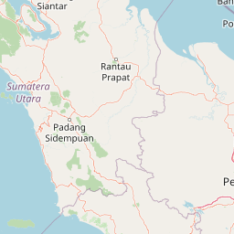
Map view of Batang Gadis National Park

Use this park location map to pinpoint Batang Gadis National Park in Indonesia, understand its exact geographic position, and read its mapped placement within the surrounding landscape more clearly.

Pigeon | © OpenStreetMap contributors

Location context for Batang Gadis National Park

North Sumatra Province
Recorded earthquake history

Review the Historical Earthquake Catalogue for Batang Gadis National Park

Examine a structured record of seismic events identified by their proximity to Batang Gadis National Park. Use these data to track historical earthquake occurrence and location patterns across the park landscapes as documented by MoriAtlas.

Batang Gadis National Park Earthquake History

Catalogued events

193 events

Strongest magnitude

Magnitude 6.1

Most recent event

May 29, 2026

This history includes earthquakes recorded inside the park or within 50 km of its borders

Park atlas

Trace the regional spread of protected areas, comparing montane forests and volcanic landscapes across North Sumatra.

Further Explore National Parks and Protected Areas Beyond Batang Gadis National Park

After reviewing Batang Gadis National Park, discover other national parks and protected areas throughout North Sumatra, Indonesia. Compare their distinct montane forest ecosystems, volcanic terrains, and critical wildlife habitats to understand the broader regional context of protected areas.
National parkWest Sumatra
198 km away#1 closest

Southeast

Kerinci Seblat National Park: National Park Protected Landscape in West Sumatra

Explore its mapped geography and regional atlas context.

Kerinci Seblat National Park represents a critical protected area, identified as a national park within Indonesia's West Sumatra province. This page provides a deep dive into its geographic footprint and landscape characteristics, serving as a key entry point for understanding the park's specific context. Users can leverage this detailed information for map-based exploration and to grasp its significance within the larger atlas of protected natural lands, focusing on its distinct geographical identity.

Area
13,750 km²
Established
1999
IUCN
II
Relief
Mountain
National parkRiau Province
About 210 km away#2 closest

Southeast

Tesso Nilo National Park: Exploring Its Protected Landscape and Geographic Identity in Riau Province

Mapped boundaries and regional park atlas context.

Uncover the core identity of Tesso Nilo National Park, a designated national park situated within Riau Province. This entry focuses on its role as a protected landscape, detailing its mapped geographic footprint and offering insights relevant for atlas exploration. Understand how its protected area status contributes to the regional geography and landscape context of Indonesia, providing a focused view for geographic discovery.

Area
1,000 km²
Established
2004
IUCN
II
Relief
Lowland
National parkWest Sumatra
About 218 km away#3 closest

South

Siberut National Park: Isolated Island Ecosystem and Endemic Wildlife Atlas

Discover the mapped geography and unique landscapes of this West Sumatra protected area.

Siberut National Park in West Sumatra, Indonesia, presents a distinct protected landscape forged by long-term geographic isolation. This national park covers a significant portion of Siberut Island, showcasing a rich tapestry of lowland dipterocarp rainforest, swamp forest, and coastal mangrove ecosystems. Explore its unique terrain, river systems, and protected boundaries to understand the extraordinary concentration of endemic species, particularly its globally significant primate populations.

Area
1,905 km²
Established
1992
IUCN
II
Climate
Tropical
National parkIndonesia
238 km away#4 closest

Northwest

Gunung Leuser National Park: A Critical Protected Landscape in Indonesia's Barisan Mountains

Discover its mountainous terrain and primate conservation significance.

Gunung Leuser National Park is a significant protected area in Indonesia, encompassing 3,208 square kilometers of diverse tropical rainforest and rugged mountainous terrain within the Barisan mountain range. Its designation as a national park highlights its role in preserving critical ecosystems, including one of the last remaining habitats for the Sumatran orangutan. This atlas entry provides a geographic overview of the park's landscape, focusing on its protected boundaries and ecological importance within the region.

Area
3,208 km²
Established
1980
IUCN
II
Relief
Mountain
Wildlife reserveMalacca
About 313 km away#5 closest

Northeast

Tanjung Tuan Wildlife Reserve: Coastal Geography and Forested Cape Mapping

Coastal dipterocarp forest and raptor sanctuary in Malacca.

This forested coastal cape is an essential protected landscape situated along the Strait of Malacca. Characterized by its dense lowland dipterocarp forest, rocky headlands, and offshore islets, the reserve provides a crucial ecological connection for migratory birds and preserves a rich history of colonial maritime navigation and defense. Its geography offers a compact view of diverse coastal environments, ranging from mangrove fringes to the elevated ridge of Batu Putih.

Area
0.607 km²
Established
1921
Relief
Upland
Climate
Tropical
Nature reserveSelangor
About 323 km away#6 closest

Northeast

Kuala Langat North Forest Reserve: Mapped Boundaries and Ecological Terrain Overview

Ancient lowland peat swamp geography in Selangor, Malaysia

Kuala Langat North Forest Reserve is an ecologically vital peat swamp remnant that shelters a range of endemic species within its 8,000 year old forest canopy. Located in the lowland terrain of Selangor, the reserve exists as a critical forest island surrounded by a matrix of development. This overview provides mapped context for the reserve's internal landscape and its role as a protected area within the shifting geography of the Klang Valley.

Area
9.576 km²
Established
1927
Relief
Lowland
Climate
Tropical
Nature reserveSelangor
About 330 km away#7 closest

Northeast

Kuala Selangor Nature Park: Mapping the Coastal Wetland and Forest Mosaic of Selangor

A Managed Nature Reserve at the Selangor River Estuary

Kuala Selangor Nature Park represents a key protected landscape in Malaysia, where secondary forest meets an intricate system of estuarine wetlands. This atlas provides a detailed look at the park, focusing on the interplay between its freshwater ponds, mangrove fringes, and the coastal bunds that govern the habitat. It serves as an essential site for understanding coastal restoration and wetland ecology in the region of Selangor.

Area
2.4 km²
Established
1987
Relief
Lowland
Climate
Tropical
National parkIndonesia
About 342 km away#8 closest

Southeast

Bukit Tigapuluh National Park: Protected Area Identity and Indonesian Geographic Context

Explore mapped boundaries and regional landscape features.

Bukit Tigapuluh National Park stands as a protected natural area within Indonesia. This entry provides detailed geographic information, focusing on its mapped extent and its contribution to the nation's conservation atlas. Understanding its place within Indonesia's broader geography highlights the significance of its protected landscape and its role in regional natural resource mapping.

Area
1,432.23 km²
Established
1995
IUCN
II
Relief
Lowland

Common questions about visiting, size, designation, and location context for Batang Gadis National Park

Batang Gadis National Park FAQs for park facts, access, geography, and protected area context

Find quick answers about Batang Gadis National Park, including protected-area facts, park geography, trail and visitor context, and how the park fits into its surrounding country and regional landscape.
MoriAtlas Explorer

Continue Your Protected Areas Search Across the Global Atlas

Deepen your exploration by continuing the structured search for national parks and protected areas worldwide. Utilize the comprehensive filtering capabilities to compare different conservation landscapes and refine your understanding of global park geography. Discover more about the distribution and characteristics of protected natural areas.

Global natural geography