Mori Atlas logo
National parkBatéké Plateau National Park

Discover the distinctive forest-savanna mosaic and regional geography of this Central African national park.

Batéké Plateau National Park: A Mapped Protected Landscape in Haut-Ogooué Province

(Parc National des Plateaux Batéké)

Batéké Plateau National Park encompasses over 2,000 square kilometers of unique savanna ecosystems and forested corridors within Gabon's Haut-Ogooué Province. This protected landscape offers a rare glimpse into the intermingling of grasslands and woodlands characteristic of Central Africa, distinct from dense rainforests. Explore its mapped boundaries and understand its significance as a testament to conservation efforts in preserving Central African natural heritage.

savanna ecosystemCentral Africaforest-savanna mosaiclion habitatplateau landscapeGabon protected area

Batéké Plateau National Park

National park

Park overview

Structured park overview, official facts, and landscape profile for Batéké Plateau National Park

Batéké Plateau National Park park facts, protected area profile, and essential visitor context

Review the core facts for Batéké Plateau National Park, including designation, size, terrain, visitor scale, habitats, and operating context in one park-focused overview.

About Batéké Plateau National Park

Batéké Plateau National Park occupies a significant geographic position in southeastern Gabon, protecting a substantial portion of the Bateke Plateau region. The landscape is characterized by a complex intermingling of savanna grasslands, forested areas, and woodland zones that together create one of Central Africa's most representative ecosystem types. This forest-savanna mosaic has long been recognized as ecologically important, representing the transitional landscapes that span the interior of the Congo Basin. The park's establishment in 2002 reflected Gabon's commitment to conserving its natural heritage, and its subsequent addition to the UNESCO World Heritage Tentative List further elevated its international recognition. The protected area serves as a critical refuge for biodiversity in a region where agricultural expansion, commercial hunting, and other human pressures have dramatically altered natural landscapes.

Quick facts and research context for Batéké Plateau National Park

Located in Haut-Ogooué Province in southeastern Gabon, Batéké Plateau National Park covers approximately 2,034 square kilometers of terrain centered on the Bateke Plateau. The protected area was established in 2002 and is managed by Gabon's National Agency for National Parks. The park is notable for its forest-savanna ecosystem, a landscape type that characterizes much of Central Africa but has faced significant pressure from human activity across the region. The park's ecological significance is underscored by its UNESCO tentative list designation and its role as a refuge for diverse wildlife species.

Protection and recognition

Verifying the official terrestrial scope and documented conservation status within the regional atlas

Batéké Plateau National Park Protection Status and Designation Details

Explore the verified protection status and documented conservation boundaries established for Batéké Plateau National Park. Factual tracking of terrestrial designations helps researchers and travelers locate accurate records within the global network of protected landscapes.

Protection details

Protection scope
Terrestrial
Transboundary protection
No
Park context

Deeper park guide and search-rich context for Batéké Plateau National Park

Batéké Plateau National Park history, landscape, wildlife, and travel context

Explore Batéké Plateau National Park through its history, landscape character, ecosystems, wildlife, conservation priorities, cultural context, and seasonal travel timing in a structured park guide built for atlas discovery and search intent.

Why Batéké Plateau National Park stands out

Batéké Plateau National Park is best known for its distinctive forest-savanna mosaic, a landscape that exemplifies the broader ecological character of Central Africa. The park gained particular scientific attention in 2015 when a single male lion was recorded within its boundaries, representing a remarkable find for a species that had become extremely rare in Gabon. Genetic analysis of the lion revealed close relations to historical lion populations from the region and neighboring Republic of the Congo, grouping with samples from Namibia and Botswana, suggesting the potential presence of a relict lion population persisting in this isolated savanna habitat.

Batéké Plateau National Park history and protected-area timeline

Batéké Plateau National Park was established in 2002 as part of Gabon's expanding network of protected areas. The creation of the park reflected growing recognition of the ecological importance of the Bateke Plateau's forest-savanna ecosystems, which had faced increasing pressure from logging, agricultural development, and commercial hunting. In 2005, the park was added to UNESCO's World Heritage Tentative List, acknowledging its potential universal significance as a natural heritage site. This designation underscored the park's role in representing Central African landscape patterns and its conservation value for unique ecosystems. The park is managed by Gabon's National Agency for National Parks, the governmental body responsible for overseeing the country's protected area network.

Batéké Plateau National Park landscape and geographic character

The Bateke Plateau, which forms the physical foundation of the national park, consists of a relatively flat to gently undulating landscape with elevations ranging between 500 and 900 meters above sea level. The park's terrain is marked by a mosaic of vegetation types, with extensive savanna grasslands dominating the plateau surfaces while forested areas persist in valleys, along watercourses, and in patches where fire and other disturbances have been less frequent. This landscape pattern is characteristic of much of Central Africa, where climatic conditions and soil types create a complex intermingling of grassland and woodland ecosystems. The plateau's geology contributes to the distinctive character of the terrain, with ancient Precambrian basement rocks underlying the area.

Batéké Plateau National Park ecosystems, habitats, and plant life

The ecological character of Batéké Plateau National Park centers on the forest-savanna ecosystem, one of Central Africa's most distinctive habitat types. This mosaic landscape supports a diversity of plant communities adapted to the interplay of seasonal fire, rainfall patterns, and soil conditions. The savanna components are dominated by grasses and scattered trees, while the forested areas contain species typical of Central African woodland and forest margins. This ecosystem type has become increasingly fragmented across its historic range, making the park's relatively intact landscapes particularly valuable for conservation. The park provides habitat for species adapted to both grassland and forest environments, creating a zone of ecological transition that supports higher biodiversity than either habitat type alone.

Batéké Plateau National Park wildlife and species highlights

Batéké Plateau National Park supports a diversity of wildlife, though the park's fauna has faced significant pressure from commercial hunting. The 2015 recording of a male lion within the park boundaries represented a remarkable discovery, as lions had become extremely rare in Gabon. Genetic analysis of the lion revealed it belongs to the Panthera leo melanochaita subspecies, with close genetic connections to lion populations from the Republic of the Congo, Namibia, and Botswana. This finding suggests the possibility of a relict lion population persisting in the isolated savanna habitats of the Bateke Plateau. The park also supports populations of large mammals, though commercial hunting targeting species for markets in Congo and Gabon poses a continuing threat to wildlife populations throughout the plateau region.

Batéké Plateau National Park conservation status and protection priorities

The conservation significance of Batéké Plateau National Park derives from its role in protecting one of Central Africa's most distinctive ecosystem types and its potential as a refuge for rare and declining species. The park's inclusion on UNESCO's World Heritage Tentative List acknowledges its potential universal value as a natural heritage site. However, the park faces significant conservation challenges, particularly from commercial hunting that targets large mammals for regional markets. The discovery of a persisting lion population highlights both the ecological importance of the area and the fragility of its wildlife communities. Conservation efforts focus on protecting the park's ecosystems while addressing the underlying pressures from hunting and habitat modification that threaten native species.

Batéké Plateau National Park cultural meaning and human context

The Bateke Plateau region has historically been inhabited by communities whose relationships with the landscape have shaped both the environment and local cultural practices. The plateau's savanna ecosystems have been influenced by human activities including fire management, grazing, and traditional land use practices over generations. These interactions have contributed to the maintenance of the open landscapes that characterize much of the park today. The cultural dimension of the plateau extends beyond local communities to include the broader Gabese and regional identities connected to this distinctive geographic area.

Top sights and standout views in Batéké Plateau National Park

The forest-savanna mosaic of Batéké Plateau National Park represents one of Central Africa's most characteristic and increasingly rare landscapes. The 2015 discovery of a lion in the park, a species nearly extirpated from Gabon, highlighted the area's significance as a potential refuge for relict wildlife populations. The park's UNESCO World Heritage Tentative List designation reflects its recognized importance as a natural heritage site. The plateau's extensive savanna habitats, interspersed with forested corridors, create a visually distinctive landscape that differs markedly from the dense rainforest typically associated with the Congo Basin region.

Best time to visit Batéké Plateau National Park

The optimal period to visit Batéké Plateau National Park falls during the dry season, typically from May through September, when precipitation is minimal and wildlife viewing conditions are most favorable. During this season, the reduced vegetation density in savanna areas improves visibility for observing wildlife, and the concentration of animals around remaining water sources enhances viewing opportunities. The landscape retains its green character from the preceding wet season while offering more comfortable conditions for exploration. Visitors should be aware that access to the park requires planning, as infrastructure is limited compared to more developed protected areas in Gabon.

Monthly climate preview

Explore long term temperature averages and seasonal precipitation cycles across the plateau

Climate Normals and Weather by Month for Batéké Plateau National Park

Long-term records from a representative elevation of 517 meters show steady year-round warmth paired with a highly pronounced dry period from June through August. Accessing the complete monthly climatology reveals precise shifts in daily maximums and average precipitation trends across the entire seasonal cycle.
Annual mean24 °C
24 °C25 °C
Jan24°
Feb25°
Mar25°
Apr25°
May24°
Jun24°
Jul24°
Aug24°
Sep24°
Oct24°
Nov24°
Dec24°
Warmest month
February

24.7 °C

Coolest month
November

23.7 °C

Wettest month
November

10 mm/day

Driest month
July

0.4 mm/day

Park location guide

Geography guide, regional context, and park location map for Batéké Plateau National Park

Batéké Plateau National Park park geography, regions, and map view in Gabon

Understand where Batéké Plateau National Park sits in Gabon through a broader geographic reading of the surrounding landscape, nearby location context, and its mapped position within the national park landscape.

How Batéké Plateau National Park fits into Gabon

Gabon is a Central African country on the Atlantic coast, positioned on the equator. It gained independence from France in 1960 and is governed as a unitary presidential republic. The country has significant oil wealth and one of the highest Human Development Index rankings in Africa, though wealth distribution remains uneven.

Wider geography shaping Batéké Plateau National Park in Gabon

Gabon is situated on the Atlantic coast of Central Africa, positioned along the equator. It borders Equatorial Guinea to the northwest, Cameroon to the north, and the Republic of the Congo to the east and south. The terrain includes coastal plains along the Atlantic, mountain ranges in the center (the Cristal Mountains and Chaillu Massif), and savanna zones in the east.

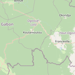
Map view of Batéké Plateau National Park

Use this park location map to pinpoint Batéké Plateau National Park in Gabon, understand its exact geographic position, and read its mapped placement within the surrounding landscape more clearly.

Pigeon | © OpenStreetMap contributors

Location context for Batéké Plateau National Park

Haut-Ogooué Province
Park atlas

Explore the surrounding protected landscapes and compare regional park geography, expanding your view from Batéké Plateau National Park.

Explore Related National Parks and Protected Areas Around Batéké Plateau National Park

Browse national parks and other protected areas that share geographic proximity or similar ecological characteristics with Batéké Plateau National Park, including its distinctive forest-savanna mosaic. Discovering these additional protected landscapes provides a broader regional context, enabling deeper atlas-style comparison of conservation efforts and mapped terrain across Central Africa.
National parkGabon
About 49 km away#1 closest

Northwest

Ogooué-Leketi National Park National Park: A Protected Landscape in Gabon's Geography

Mapped boundaries and regional protected-area context.

Delve into the protected landscape of Ogooué-Leketi National Park, a national park situated in Gabon. This entry provides crucial context for understanding the park's geographic footprint and its role as a conservation area. Examine the mapped terrain and discover how Ogooué-Leketi National Park fits into the regional geography of Central Africa, offering an atlas-driven perspective on its protected status.

Protected areaGabon
About 117 km away#2 closest

Northwest

Parc de la Lékédi: Protected Area Geography and Landscape Context in Southeastern Gabon

A managed savanna and forest mosaic reserve in the Haut-Ogooué province.

Spanning 14,000 hectares of sandstone terrain, Parc de la Lékédi represents a distinct protected landscape in Gabon. The reserve merges conservation goals with scientific research on primates, utilizing a network of lakes and riverine corridors that support a high concentration of forest and savanna species in a highly managed, ecologically significant environment.

Area
140 km²
Established
1990
Relief
Upland
Climate
Tropical
National parkGabon
About 201 km away#3 closest

West

Birougou National Park: Mapped Protected Landscape and Regional Geography in Gabon

Explore the geographic extent and conservation context of this national park.

Birougou National Park is an important protected area situated in Gabon, offering a distinct focus for geographic and atlas-based discovery. This national park serves as a significant element within the country's network of conservation landscapes, providing a focal point for understanding mapped terrain and regional geographic patterns. Users can explore its protected boundaries and gain insight into its specific environmental context within Central Africa, making it a vital entry for atlas exploration of Gabon's natural heritage.

Area
690 km²
Established
2002
IUCN
II
Relief
Mountain
National parkCuvette-Ouest Department
About 276 km away#4 closest

North

Odzala-Kokoua National Park National Park: Mapped Protected Landscape in Cuvette-Ouest

Explore its geographic boundaries and regional terrain.

Odzala-Kokoua National Park is a key national park entity, offering a distinct protected landscape within the Cuvette-Ouest Department. This page provides an atlas-style exploration of its mapped boundaries and geographic context. Delve into the specifics of this protected area to understand its contribution to the regional geography and natural landscape, facilitating structured discovery of its terrain.

Area
13,500 km²
Established
1935
IUCN
II
Visitors
50 annual
Watercolor painting of a landscape with grassy areas, a lake, and distant hills under a light sky
National parkGabon
About 288 km away#5 closest

Northwest

Lopé National Park: Gabon's Protected Landscape and National Park Geography

Explore mapped boundaries and natural terrain in Central Africa.

Delve into Lopé National Park, a designated national park situated in Gabon. This protected area serves as a crucial point for understanding the nation's geography and the distribution of its conservation landscapes. As an entry in the MoriAtlas, it offers a detailed view of its mapped territory and its contribution to the broader regional context of Central Africa, emphasizing its role in protected area atlas exploration.

Area
4,910 km²
Established
2002
IUCN
II
Relief
Mixed relief
National parkGabon
About 295 km away#6 closest

Northwest

Ivindo National Park: A Protected Rainforest Landscape in Gabon

Explore its waterfalls, diverse ecosystems, and mapped geographic context.

Ivindo National Park represents a significant protected landscape within Gabon, spanning a vast area of intact tropical rainforest. Recognized as a UNESCO World Heritage Site, the park is defined by the Ivindo River and its dramatic waterfalls, including the famous Kongou and Mingouli Falls. Its geography includes mountainous terrain and vital riverine ecosystems, supporting critical populations of forest elephants and great apes. This page offers a gateway to understanding the park's protected status, its unique natural features, and its role in the broader geography of Central Africa.

Area
3,000 km²
Established
2002
IUCN
II
Relief
Mixed relief
National parkGabon
About 297 km away#7 closest

North

Mwangné National Park: Gabon's Protected Landscape for Geographic Discovery

Explore the mapped boundaries and regional context.

Gain a detailed understanding of Mwangné National Park, a key protected area within Gabon. This page offers an atlas-centric view, highlighting its geographic significance and the characteristics of its protected landscape. Delve into the park's mapped boundaries and its role within the broader natural terrain of Central Africa, providing essential context for geographic exploration.

National parkGabon
About 319 km away#8 closest

West

Waka National Park: A Mapped Protected Landscape in Gabon's Geography

Explore the natural terrain and park boundaries of this national park.

Waka National Park in Gabon represents a vital protected landscape for geographic exploration. This dedicated detail page offers insight into the park's specific mapped area and its place within the country's broader natural terrain. Understand its context as a national park, contributing to the atlas of protected areas in Central Africa. Discover the geographic identity of this significant natural reserve.

Area
1,060 km²
Established
2002
IUCN
II
Relief
Mountain

Common questions about visiting, size, designation, and location context for Batéké Plateau National Park

Batéké Plateau National Park FAQs for park facts, access, geography, and protected area context

Find quick answers about Batéké Plateau National Park, including protected-area facts, park geography, trail and visitor context, and how the park fits into its surrounding country and regional landscape.
MoriAtlas Explorer

Continue Your Protected Areas Search Across the Global Atlas

Deepen your exploration by continuing the structured search for national parks and protected areas worldwide. Utilize the comprehensive filtering capabilities to compare different conservation landscapes and refine your understanding of global park geography. Discover more about the distribution and characteristics of protected natural areas.

Global natural geography