
Mori Atlas logo
State or regional parkBelum-Temengor

Mapping the ancient rainforest terrain, river valleys, and lake island archipelagos of this critical conservation region.

Belum-Temengor Forest Complex and Protected Landscape Geography in Northern Perak, Malaysia

(Royal Belum State Park (Taman Negeri Diraja Belum))

Belum-Temengor stands as the largest unbroken forest complex in Peninsular Malaysia, forming a vast, ancient wilderness that stretches from the Perak interior to the border with Thailand. The landscape is defined by a dense mantle of dipterocarp forest, rugged hill ridges of the Titiwangsa Range, and the expansive, island-dotted waters of Tasik Temengor. As a cornerstone of the Central Forest Spine, this protected region offers a unique geography where freshwater habitats and deep tropical rainforests converge.

tropical rainforestancient forestdipterocarp forestlowland rainforesthill forestfreshwater lake
A digital illustration of a tall waterfall flowing into a calm lake, surrounded by a dense tropical forest with silhouetted trees in the foreground water.

Belum-Temengor

State or regional park

Park overview

Structured park overview, official facts, and landscape profile for Belum-Temengor

Belum-Temengor park facts, protected area profile, and essential visitor context

Review the core facts for Belum-Temengor, including designation, size, terrain, visitor scale, habitats, and operating context in one park-focused overview.

About Belum-Temengor

Belum-Temengor is a vast, contiguous tract of tropical rainforest in northern Peninsular Malaysia, anchored in the Hulu Perak district of Perak and reaching up to the international border with Southern Thailand. While the name refers to a complex rather than a single park, it forms one of the most ecologically important forest landscapes in Malaysia. The northern portion, Belum, runs along the border and contains dense, primary hill forest, while the southern Temengor area is shaped by the impoundment of waters behind a hydroelectric dam, creating Tasik Temengor, a 15,200 hectare lake scattered with hundreds of forested islands.

The forest complex is a cornerstone of the Malaysian Central Forest Spine, a national-scale effort to maintain forested corridors that link major forest blocks across Peninsular Malaysia. It has been recognised as an Environmentally Sensitive Area of the highest rank under the National Physical Plan, reflecting its role as a critical water catchment and habitat refuge. BirdLife International has also designated it an Important Bird Area, while the Royal Belum State Park, gazetted within the complex in 2007, provides a formal state-level protection status for part of the Belum Forest Reserve.

Ecologically, Belum-Temengor's reputation rests on both its ancient character and its unusual concentration of wildlife. The forest is believed to have existed for over 130 million years, making it older than the Amazon and Congo basins, and has been described as one of the world's most intact examples of a primary tropical rainforest. This age and continuity are believed to underpin the rich biodiversity found here, from dipterocarp hardwoods and orchids to the full suite of Malaysian hornbills. Beyond its formal protected status, however, Belum-Temengor remains a working landscape, with logging and land-use debates still influencing its conservation outlook.

For visitors and naturalists, the chief draw is the sense of wilderness. Lake Temengor offers an island-hopping environment framed by forested ridges, while Belum's streams, salt licks, and waterfalls showcase the rainforest at its most pristine. The forest is also the cultural home of the Orang Asli Jahai people, and remnants of older Malay settlements persist within the landscape, adding a human dimension to a place otherwise defined by its ecological value.

Quick facts and research context for Belum-Temengor

Belum-Temengor covers roughly 117,500 hectares in the Hulu Perak region of Perak, Malaysia, extending up to the Malaysia-Thailand border. The Royal Belum State Park was gazetted within this complex on 3 May 2007 and is managed by the Perak State Parks Corporation. The surrounding landscape includes the Tasik Temengor reservoir, a large man-made lake dotted with hundreds of islands, formed by damming for hydroelectric power. The area is classified as Environmentally Sensitive Area Rank 1 under Malaysia's National Physical Plan and is also recognised by BirdLife International as an Important Bird Area.

Protection and recognition

Examine the designated protection timeline and transboundary management framework.

Belum-Temengor Protection Status and Terrestrial Conservation History

Documented terrestrial protection records for Belum-Temengor trace established designation timelines originating in 2007. Verified administrative frameworks outline the scope of official conservation measures and international status for the protected landscape.

Protection details

Protection scope
Terrestrial
Designated year
2007
Transboundary protection
Yes
Park context

Deeper park guide and search-rich context for Belum-Temengor

Belum-Temengor history, landscape, wildlife, and travel context

Explore Belum-Temengor through its history, landscape character, ecosystems, wildlife, conservation priorities, cultural context, and seasonal travel timing in a structured park guide built for atlas discovery and search intent.

Why Belum-Temengor stands out

Belum-Temengor is best known for being among the oldest rainforests in the world and the largest unbroken forest block left in Peninsular Malaysia. It is especially renowned for harboring all ten hornbill species found in Malaysia within a single forest and for supporting the full set of Malaysia's most threatened mammal species. The combination of ancient dipterocarp-dominated forests, island-strewn freshwater lakes, and continuous wilderness stretching to the Thai border is what defines its ecological identity. The complex is also a key refuge for the endangered Malayan tiger, which has nonetheless suffered steep declines within the reserve.
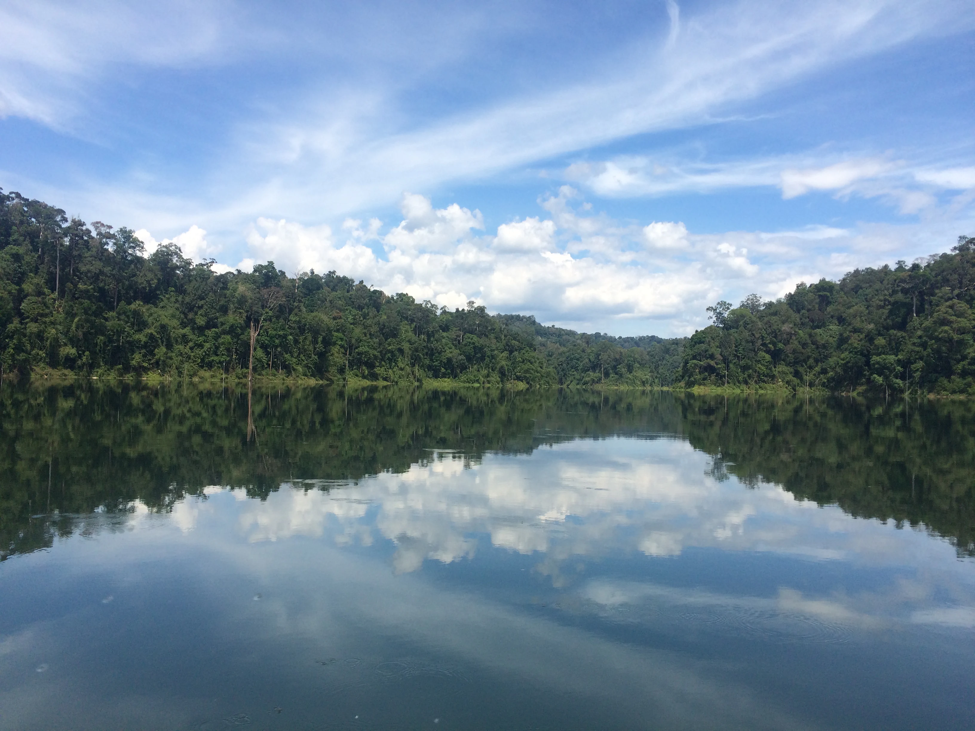
A wide, eye-level shot of Temenggor Lake in Malaysia, with dense tropical rainforest lining the shores and the bright blue sky and white clouds reflected perfectly in the still water.
A calm, reflective view of Temenggor Lake surrounded by dense rainforest.

Belum-Temengor history and protected-area timeline

Belum-Temengor takes its name from Kampung Belum Lama, a Malay settlement established deep within the forest. According to local tradition, the name 'Belum' echoes the buzzing sound produced by wood-boring insects, highlighting how closely the forest and its human inhabitants have long been intertwined. The forest was historically home to the Orang Asli Jahai, a Negrito community who lived on the shores of Tasik Temengor before being relocated during the British colonial period in the 1950s.

During the colonial era, the area also became a wartime refuge. As the British colonial authorities fought communist insurgents in the early postwar period, the dense forests of Belum served as a hiding place. By 1952, the British directed the relocation of former forest villagers to Bendang Puru, near the town of Grik, in their counter-insurgency efforts, displacing communities that had lived within the forest for generations.

In the modern era, the most significant historical event for Belum-Temengor came on 3 May 2007, when the State Government of Perak gazetted 1,175 square kilometres of the Belum Forest Reserve as the Royal Belum State Park. This declaration established the formal state park that now sits within the broader forest complex, though the surrounding Temengor area and parts of the Belum forest reserve remain classified as production forest. Conservation groups, including the Malaysian Nature Society and WWF, have continued to advocate for stronger protection, particularly against logging pressure in Temengor and against plans to convert natural forest into plantation forest along the East-West Highway corridor.

Belum-Temengor landscape and geographic character

Belum-Temengor lies along the northern reaches of the Titiwangsa Range, the long spine that runs down the centre of Peninsular Malaysia. The terrain is dominated by steep, forested ridges and valleys, with many streams carving through the hills and feeding into the broader river system that drains north toward the Perak River. Above this rugged hill country, the canopy forms an unbroken green mantle that has remained largely intact for millions of years.

The most striking visual element of the complex is Tasik Temengor, a large man-made lake created for hydroelectric power generation. Covering roughly 15,200 hectares, the lake transforms the southern section of the forest into an island-studded waterworld. Hundreds of islands rise from the lake, each covered in primary or secondary forest, giving the area an archipelago-like character unique within Peninsular Malaysia. The lake's sheltered coves, rocky shorelines, and forested islands define the scenery of Temengor, while Belum itself features fast-flowing rivers, hidden waterfalls, and remote salt licks visited by wildlife.

Throughout the complex, the elevation gradient creates layered vegetation, from lowland dipterocarp forest along the rivers and lakes to hill and upper hill forest along the ridgelines. This layering underpins the diversity of habitats found across Belum-Temengor and contributes to the visual richness of its landscapes, from open lake vistas to the dense, light-filtered interiors of ancient rainforest.

Belum-Temengor ecosystems, habitats, and plant life

Belum-Temengor is recognised as one of the most botanically significant forest complexes in Peninsular Malaysia. The vegetation is dominated by tropical lowland and hill rainforest, with an extensive canopy of dipterocarps and other tall hardwoods. Among the commercially and ecologically important tree species found here are meranti, cengal, keruing, and merbau, many of which have become rarer in other parts of the country due to historic logging.

Below the canopy, the understorey and ground layer support a wide range of flowering plants, herbs, and epiphytes. Surveys have recorded more than 89 moss species, 48 fern or lycophyte taxa, and over 374 species of flowering plants across 84 families, including 15 endemic species. The orchid flora is exceptional, with more than 150 species documented. The forest is also home to all three Rafflesia species known to occur in the surrounding region: Rafflesia cantleyi, R. kerri, and R. azlanii. These parasitic plants produce the largest flowers in the world and are a global draw for naturalists visiting Belum.

The forest's age, estimated at over 130 million years, is believed to underlie this exceptional botanical richness. Old growth conditions are evident in the structural complexity of the canopy, the presence of large emergent trees, and the continuous coverage of undisturbed primary forest across much of Belum. Together with the mosaic of habitats created by the lake, rivers, and ridges, the vegetation patterns of Belum-Temengor create a deeply layered ecological environment.

Belum-Temengor wildlife and species highlights

Belum-Temengor is widely regarded as one of the richest wildlife refuges in Peninsular Malaysia. The forest complex is home to more than 300 bird species, with its hornbill fauna being especially celebrated. It is the only known forest in Malaysia where all ten hornbill species occur together, including the white-crowned, bushy-crested, wrinkled, wreathed, plain-pouched, black, Oriental pied, rhinoceros, great, and helmeted hornbills.

Among mammals, Belum-Temengor supports a remarkable concentration of threatened species. Resident populations include the Malayan tiger, Asian elephant, white-handed gibbon, Malayan sun bear, Malayan tapir, seladang (Malayan gaur), wild boar, and a variety of deer. Smaller carnivores such as the clouded leopard and the leopard cat are also present, along with several other wild cat species. The complex is often highlighted for hosting around 14 of the world's most threatened mammal species within a single continuous forest.

Reptiles and amphibians also thrive, with 18 species of frogs and toads and around 67 species of snakes recorded. The insect fauna is exceptionally rich, with more than 132 beetle species documented, 97 butterfly species, and a diverse community of stick insects, lantern flies, stalk-eyed flies, and the violin fly. Despite this abundance, poaching and prey depletion have taken a heavy toll on the tiger population, which reportedly dropped by around 60% between the early 2010s and 2019, underscoring the ongoing pressures facing the forest's wildlife.

Belum-Temengor conservation status and protection priorities

Belum-Temengor is nationally recognised as an Environmentally Sensitive Area of the highest rank and internationally recognised as an Important Bird Area by BirdLife International. It also serves as a critical water catchment forest and forms a central node in the Central Forest Spine, the federal initiative to maintain forested connectivity across Peninsular Malaysia. The Malaysian federal government has identified the broader area as essential for long-term ecological health, even though the level of formal protection within the complex varies.

The Royal Belum State Park, gazetted on 3 May 2007, provides the strongest formal protection within the complex, covering around 117,500 hectares of the Belum section. The Temengor portion, however, remains largely classified as production forest, and ongoing logging has driven significant deforestation, particularly along accessible corridors. There have also been proposals to convert stretches of natural forest along the East-West Highway into plantation forest, raising further concerns among conservationists.

Organisations such as the Malaysian Nature Society and WWF continue to campaign for the full gazettement of both Belum and Temengor as a single integrated protected area. Their efforts are weighed against state revenue from logging, which has historically generated significant income for Perak. The conservation significance of Belum-Temengor lies not only in what it currently protects, but also in what it could represent if fully secured: the last great contiguous rainforest of Peninsular Malaysia, stretching unbroken from the ridge tops of the Titiwangsa Range to the forested islands of Tasik Temengor and across to the Thai border.

Belum-Temengor cultural meaning and human context

Before the era of hydroelectric development and modern conservation, Belum-Temengor was inhabited by forest-dependent communities who lived largely within the forest itself. The Orang Asli Jahai, a Negrito people, originally lived along the shores of Tasik Temengor and throughout the Belum area, drawing their livelihoods from hunting, fishing, and forest produce. The forest also supported older Malay settlements, including the village after which the area is named, Kampung Belum Lama.

During the British colonial period, the forest gained a darker chapter in its history. Its remoteness made it a refuge for communist insurgents in the early postwar years, and in 1952 the British authorities relocated forest communities, including the Jahai, to settlements near Grik as part of broader counter-insurgency operations. These relocations transformed the demographic map of the area and severed long-standing connections between people and forest.

Today, cultural ties to the forest persist through the descendants of these displaced communities, as well as through traditional knowledge of the forest that continues to inform conservation work. The forest's name itself, derived from the call of wood-boring insects, is a linguistic reminder of the close, observant relationship that local Malay and Orang Asli communities have historically maintained with the rainforest.

Top sights and standout views in Belum-Temengor

Belum-Temengor's standout qualities include its status as the largest unbroken rainforest in Peninsular Malaysia and its reputed age of more than 130 million years, making it older than the Amazon and Congo. The combination of ancient dipterocarp forests with forested islands scattered across Tasik Temengor creates a landscape that is as visually distinctive as it is ecologically important. It is also the only forest in Malaysia known to host all ten native hornbill species within a single continuous habitat, alongside more than 300 bird species overall. Supporting 14 of the world's most threatened mammal species, including the Malayan tiger and Asian elephant, the complex stands as a critical refuge for wildlife that has been lost or diminished across much of Southeast Asia.

Best time to visit Belum-Temengor

The optimal time to experience Belum-Temengor is during the drier months, roughly from February to September, when calmer lake conditions make island-hopping on Tasik Temengor more comfortable and forest trails are more accessible. The transitional months on either side of the dry period can offer lush, recently refreshed vegetation and active fruiting, which in turn supports richer wildlife viewing, particularly for birds and primates. Heavy rainfall associated with the monsoon season can make river and lake travel difficult and limit access to remote areas of the forest. Because Belum-Temengor's appeal lies as much in its ancient forests and quiet lakeshores as in any single dramatic vista, visiting during settled weather tends to bring out the full character of the landscape.

Monthly climate preview

Examine long-term representative coordinate measurements across twelve distinct months

Belum-Temengor Climate Normals, Annual Temperature and Precipitation Profiles

Representative coordinate records reveal sustained monthly temperatures alongside measured daily precipitation shifts throughout the year. Detailed monthly climate profiles provide complete statistical breakdowns for detailed park research.
Annual mean24 °C
22 °C25 °C
Jan22°
Feb23°
Mar24°
Apr25°
May25°
Jun24°
Jul24°
Aug24°
Sep24°
Oct24°
Nov23°
Dec23°
Warmest month
April

24.8 °C

Coolest month
January

22.4 °C

Wettest month
November

15.4 mm/day

Driest month
February

2.7 mm/day

Park location guide

Geography guide, regional context, and park location map for Belum-Temengor

Belum-Temengor park geography, regions, and map view in Malaysia

Understand where Belum-Temengor sits in Malaysia through a broader geographic reading of the surrounding landscape, nearby location context, and its mapped position within the national park landscape.

How Belum-Temengor fits into Malaysia

Malaysia is a federal constitutional monarchy located in Southeast Asia. The country consists of 13 states and three federal territories, divided by the South China Sea into Peninsular Malaysia on the Indochinese Peninsula and East Malaysia on the island of Borneo. With a population of over 34 million, it achieved independence from Britain in 1957 and became a modern federation in 1963. The country is recognized for its multicultural population, tropical climate, and significant economic role in the region.

Wider geography shaping Belum-Temengor in Malaysia

Malaysia occupies a strategic position in Southeast Asia, split by the South China Sea into two distinct regions. Peninsular Malaysia lies on the Indochinese Peninsula, sharing a land border with Thailand to the north and maritime borders with Singapore, Vietnam, and Indonesia. East Malaysia occupies the northern portion of Borneo, sharing land borders with Brunei and Indonesia, and maritime borders with the Philippines and Vietnam. The country's terrain includes coastal plains, mountain ranges such as the Titiwangsa in the peninsula, and extensive tropical rainforests.

Map view of Belum-Temengor

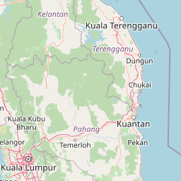
Use this park location map to pinpoint Belum-Temengor in Malaysia, understand its exact geographic position, and read its mapped placement within the surrounding landscape more clearly.

Pigeon | © OpenStreetMap contributors

Location context for Belum-Temengor

Perak

Visual reference of ancient rainforest terrain and protected lake habitats

Belum-Temengor Landscape and Scenery Photography

Visual documentation captures the rugged hill forests, river valleys, and island-studded freshwater lake environments defining Belum-Temengor. Examining these protected landscapes reveals the dense forest canopy, distinct elevation gradients, and natural habitat character of an ancient wilderness.

A wide, eye-level shot of Temenggor Lake in Malaysia, with dense tropical rainforest lining the shores and the bright blue sky and white clouds reflected perfectly in the still water.

A view of dense green rainforest hills covered in low hanging clouds and mist, reflecting into the calm water of a lake with partially submerged tree trunks.

Park atlas

Compare surrounding regional reserves and tropical forest habitats across the Central Forest Spine.

Exploring Parks Near Belum-Temengor and Connected Protected Landscapes

Browse nearby national parks and protected areas sharing the mountainous terrain of the surrounding region. Comparing adjacent reserves reveals broader ecological patterns across the wider tropical forest landscape.
National parkNarathiwat Province
About 106 km away#1 closest

North

Budo, Su-ngai Padi National Park: Protected Tropical Rainforest Geography

Explore mapped boundaries and mountain landscapes in Southern Thailand.

Budo, Su-ngai Padi National Park is a critical protected area safeguarding one of Thailand's last significant tracts of intact tropical rainforest. Situated within the rugged Budo mountain range of Narathiwat Province, its landscape is defined by dense evergreen forests, steep terrain, and numerous waterfalls. This national park offers substantial geographic context for understanding conservation landscapes and regional terrain in peninsular Thailand, serving as a valuable addition to any atlas exploration.

Area
341 km²
Established
1999
IUCN
II
Relief
Mountain
National parkMalaysia
About 128 km away#2 closest

West

Penang National Park: Exploring Malaysia's National Park Atlas and Protected Landscapes

Understand the mapped geography and protected terrain of Penang National Park.

Penang National Park represents a crucial element within Malaysia's network of protected areas. This page offers detailed information for atlas-driven exploration, focusing on the park's specific geography, its mapped boundaries, and its contribution to the regional landscape. Gain a structured understanding of Penang National Park's identity as a protected national park, providing essential context for geographic discovery.

Area
12.13 km²
Established
2003
IUCN
II
Relief
Mixed relief
National parkSongkhla Province
About 139 km away#3 closest

Northwest

Khao Nam Khang National Park: National Park, Mapped Boundaries, and Regional Geography

Explore protected landscape identity and atlas context.

Gain detailed insights into Khao Nam Khang National Park, a key protected area situated within Songkhla Province. This national park serves as a critical reference point for understanding regional geography, its specific mapped boundaries, and its role as a conservation landscape. Discover its unique geographic context, vital for comprehensive atlas exploration of Thailand's natural heritage.

Area
212 km²
Established
1990
IUCN
II
Visitors
1.8K annual
A watercolor illustration of a wooden pier extending into calm wetland waters, with lush green shorelines and trees on both sides.
State or regional parkTerengganu
About 152 km away#4 closest

East

Setiu Wetlands State Park: Geography and Protected Area Atlas of Terengganu

Coastal lagoons, mangrove forests, and riverine ecosystems

Encompassing the largest natural wetland on Malaysia's east coast, Setiu Wetlands State Park serves as a critical protected landscape where sea, sand, and forest meet. This atlas entry details the park's 23,000 hectare expanse, highlighting the complex hydrological network of lagoons and river basins that support diverse habitats, including peat swamps and seagrass beds.

Area
230 km²
Established
2018
Relief
Lowland
Climate
Tropical
Marine protected areaKedah
About 156 km away#5 closest

West

Payar Island Marine Park: A Comprehensive Geographic Atlas of Marine Protected Areas

Mapping reef systems and island geography in the northern Strait of Malacca.

Payar Island Marine Park serves as a significant marine protected area centered on the islands of Payar, Kaca, Lembu, and Segantang. This profile details the park's coastal geography, its signature soft coral habitats like the Coral Garden, and its role as a regional sanctuary for marine biodiversity within the Kedah territorial waters.

Area
0.29 km²
Established
1994
Relief
Upland
Climate
Tropical
National parkPahang
About 156 km away#6 closest

Southeast

Taman Negara National Park: Pahang Protected Area with Mapped Boundaries for Geographic Discovery

Explore the unique landscape context within Pahang, Malaysia.

Delve into Taman Negara National Park, a significant protected area situated in Pahang, Malaysia. This detailed view highlights the park's mapped boundaries and its contribution to the regional geography. Understand the protected landscape and its place within the natural terrain of Peninsular Malaysia, essential for atlas-based geographic exploration.

Area
4,343 km²
Established
1938
IUCN
II
Relief
Mixed relief
An illustrative style image of a dramatic mountain valley featuring cliffs, two waterfalls, and a forested foreground at sunset.
Marine protected areaTerengganu
About 159 km away#7 closest

East

Perhentian Islands Marine Protected Area: Terengganu Coastal and Archipelago Geography

Mapped marine boundaries and tropical island terrain

An immersive look at the Perhentian Islands, a protected nine-island archipelago in the South China Sea. Analyze the distinct marine geography, from fringing coral reefs and shallow reef flats to the forested inland hills of Perhentian Besar and Perhentian Kecil. This overview provides spatial context for one of Malaysia's most recognizable marine environments, emphasizing the protected status of its surrounding waters and reef habitats.

Area
15.955 km²
Established
1994
Relief
Lowland
Climate
Tropical
Stylized illustration of a forested area featuring a waterfall, large leaves, and a winding path
National parkSatun Province
About 169 km away#8 closest

Northwest

Thale Ban National Park: Mapped Protected Landscape and Unique Wetland Ecosystem in Satun Province

Explore karst and granite mountains, natural lake geography, and diverse biodiversity.

Thale Ban National Park offers a fascinating study in protected landscape geography, centered around a rare natural lake formed by geological damming. This national park in Satun Province, Thailand, showcases a striking contrast between ancient limestone karst formations and younger granite mountains, contributing to its unique biodiversity and ecosystems. Its position near the Malaysian border highlights its role in regional conservation, making it a key site for understanding mapped terrain and protected natural areas.

Area
196 km²
Established
1980
IUCN
II
Visitors
12K annual

Common questions about visiting, size, designation, and location context for Belum-Temengor

Belum-Temengor FAQs for park facts, access, geography, and protected area context

Find quick answers about Belum-Temengor, including protected-area facts, park geography, trail and visitor context, and how the park fits into its surrounding country and regional landscape.
MoriAtlas Explorer

Continue Your Protected Areas Search Across the Global Atlas

Deepen your exploration by continuing the structured search for national parks and protected areas worldwide. Utilize the comprehensive filtering capabilities to compare different conservation landscapes and refine your understanding of global park geography. Discover more about the distribution and characteristics of protected natural areas.

Global natural geography