Mori Atlas logo
National parkBen-Gurion Tomb National Park

Discover the memorial landscape and geographic setting of this unique national park.

Ben-Gurion Tomb National Park: Protected Landscape Atlas and Desert Geography

Ben-Gurion Tomb National Park represents a significant protected landscape within Israel's stark Negev Desert. Situated near Midreshet Ben-Gurion, this national park encompasses the burial site of David and Paula Ben-Gurion, a deliberate choice reflecting their deep connection to the desert land. The approximately 90 dunams of landscaped garden dramatically overlook the canyon of Nahal Tzin, offering a distinctive blend of memorial solemnity and natural geographic context for atlas exploration.

memorial sitedesert landscapenational parkIsraeli heritagepilgrimage siteNegev Desert

Ben-Gurion Tomb National Park

National park

Park overview

Structured park overview, official facts, and landscape profile for Ben-Gurion Tomb National Park

Ben-Gurion Tomb National Park park facts, protected area profile, and essential visitor context

Review the core facts for Ben-Gurion Tomb National Park, including designation, size, terrain, visitor scale, habitats, and operating context in one park-focused overview.

About Ben-Gurion Tomb National Park

Ben-Gurion Tomb National Park occupies a special place in Israel's landscape of memory and national identity. Unlike most national parks that preserve natural landscapes or archaeological sites, this protected area centers on a deliberately chosen burial location that reflects the values and personality of the individual it commemorates. The park's creation emerged from Ben-Gurion's own decision to decline burial in the nation's primary memorial cemetery on Mount Herzl, instead requesting to be laid to rest in the southern desert near the community where he and his wife spent their final years. The resulting memorial landscape combines elements of traditional memorial design with the natural harshness of the desert environment, creating a contemplative space that looks out over the deep wadi of Nahal Tzin. The site also incorporates the former library building at the foot of the burial plaza, which now houses the Ben-Gurion Heritage Institute, adding an educational dimension to the memorial. The park remains an important destination for those seeking to connect with Israel's founding history and the legacy of its most iconic leader.

Quick facts and research context for Ben-Gurion Tomb National Park

The memorial site is situated in the Central Negev region, near the former kibbutz where Ben-Gurion spent his later years. The burial square features distinctive tombstones designed by sculptor Ezra Orion, characterized by simple rectangular stone forms with diagonal tablets bearing the names and dates of the deceased. The garden's winding paths lead visitors through a landscape of stepped stone slabs, vegetation, and papelion trees toward the gravesite. The park was designed through a public architectural competition won by landscape architects Lipa Yahlom and Dan Tzur. Paula Ben-Gurion was buried at the site in January 1968, and David Ben-Gurion was buried beside her in December 1973.

Protection and recognition

Analyzing official designation history, terrestrial limits, and international database records

Ben-Gurion Tomb National Park Protection Status and Terrestrial Boundaries

Documented conservation data details the terrestrial designation framework and official protection status of Ben-Gurion Tomb National Park. Reviewing registered boundaries and official management parameters clarifies the park's exact position within regional environmental preservation networks.

Protection details

Protection scope
Terrestrial
Transboundary protection
No
Park context

Deeper park guide and search-rich context for Ben-Gurion Tomb National Park

Ben-Gurion Tomb National Park history, landscape, wildlife, and travel context

Explore Ben-Gurion Tomb National Park through its history, landscape character, ecosystems, wildlife, conservation priorities, cultural context, and seasonal travel timing in a structured park guide built for atlas discovery and search intent.

Why Ben-Gurion Tomb National Park stands out

Ben-Gurion Tomb National Park is best known as the burial site of David Ben-Gurion, the visionary leader who declared Israel's independence in 1948 and served as its first Prime Minister. The park represents a deliberate choice by Ben-Gurion to be buried in the desert rather than in the nation's grand cemetery, reflecting his deep connection to the land of Israel and particularly to the development of the Negev. The site's design successfully balances memorial solemnity with an inviting park atmosphere, allowing visitors to make a pilgrimage in a setting that is both modest and majestic.

Ben-Gurion Tomb National Park history and protected-area timeline

The history of Ben-Gurion Tomb National Park begins with the death of Paula Ben-Gurion on January 29, 1968. Upon her death, David Ben-Gurion was required to choose a burial site for both his wife and himself. Rather than accepting burial in the nation's grand plot on Mount Herzl in Jerusalem, Ben-Gurion selected a plot south of the library building at Sde Boker, near the kibbutz where he and his wife had lived. Paula's funeral was held at this site on January 30, 1968. Planning for the tomb estate by the National Parks Authority began after her burial but before Ben-Gurion's own death, with earthworks carried out that raised the level of the grave square by several meters. David Ben-Gurion died on December 1, 1973, and was buried at the site two days later. In May 1974, the National Parks Authority held a public architectural competition for the design of the burial square and surrounding park. Of 54 proposals submitted by architects, artists, and sculptors, the design by landscape architects Lipa Yahlom and Dan Tzur was selected. The park has experienced acts of vandalism, including a 1989 desecration by an ultra-Orthodox organization and a 2005 incident involving graffiti on the grave.

Ben-Gurion Tomb National Park landscape and geographic character

The park occupies a dramatic position in the Negev Desert, overlooking the deep channel of Nahal Tzin (Nahal Zin). This wadi cuts through the desert landscape, creating a striking visual boundary between the cultivated memorial garden and the raw desert beyond. The garden covers approximately 90 dunams, most of which is covered with vegetation that contrasts markedly with the surrounding arid terrain. A winding path leads from the entrance parking area through the landscaped garden to the burial ground in the southeastern section. The path is lined with stepped stone slabs and rocks, with vegetation and trees planted alongside to give the appearance of a river channel. The burial square itself is surrounded by stepped rock slabs that serve as seating, with a low stone fence along the southern edge. From this elevated position, visitors look south across the desert landscape and the canyon below.

Ben-Gurion Tomb National Park ecosystems, habitats, and plant life

Despite its desert setting, Ben-Gurion Tomb National Park contains significant planted vegetation that creates an oasis-like atmosphere within the harsh Negev landscape. The garden features various trees and plants, with particular emphasis on papelion trees that contribute to the site's peaceful ambiance. The contrast between the cultivated garden and the natural desert beyond creates a distinctive ecological boundary, with the planted areas representing a deliberate transformation of the landscape to serve memorial purposes. The vegetation is maintained through irrigation in this arid environment, demonstrating the intentional design choice to create a green memorial space rather than leaving the site in its natural desert state.

Ben-Gurion Tomb National Park conservation status and protection priorities

As a national park managed by the Nature and Gardens Authority, Ben-Gurion Tomb National Park represents Israel's commitment to preserving significant sites of national memory alongside natural and cultural heritage. The park's designation as a national park rather than merely a memorial or heritage site places it within the framework of Israeli environmental protection and landscape preservation. The site's creation involved significant earthworks and landscape design, transforming a portion of the desert into a maintained garden while preserving the broader desert context. This approach reflects a conservation philosophy that values both the memorial function and the ecological setting, allowing the harsh desert landscape to remain visible and present around the cultivated memorial garden.

Ben-Gurion Tomb National Park cultural meaning and human context

Ben-Gurion Tomb National Park carries profound significance within Israeli national identity and collective memory. The choice of burial location reflects David Ben-Gurion's personal philosophy and his lifelong dedication to the development and settling of the Land of Israel, particularly the Negev region. By choosing to be buried in the desert rather than in the nation's primary cemetery, Ben-Gurion made a statement about his values and priorities, emphasizing the importance of the land itself and the pioneering spirit of desert development. The site now serves as a destination for educational visits by students and citizens seeking to connect with Israel's founding history. The incorporation of the former library building as home to the Ben-Gurion Heritage Institute adds an archival and educational component to the physical memorial, ensuring that the site serves not only as a place of burial but also as a center for studying and preserving Ben-Gurion's legacy and the early years of the Israeli state.

Top sights and standout views in Ben-Gurion Tomb National Park

The park's most significant highlight is the burial site of David and Paula Ben-Gurion, marked by distinctive tombstones designed by sculptor Ezra Orion. The tombstones feature simple rectangular stone forms with diagonal tablets bearing the names, birth and death dates, and immigration years of the deceased. The burial square provides panoramic views over Nahal Tzin canyon and the desert landscape. The winding garden path creates a contemplative journey from the entrance to the gravesite, while stepped stone slabs throughout the garden serve both as path elements and seating. The annual state memorial ceremony for Ben-Gurion and his wife is held at the site during the period around Kislev, drawing official recognition and continuing the site's role in Israeli ceremonial life.

Best time to visit Ben-Gurion Tomb National Park

The park can be visited throughout the year, though visitors should consider the Negev Desert's climate when planning a trip. Summer months can bring extreme heat, making midday visits uncomfortable, while winter months may offer milder temperatures but also occasional rain. The desert setting provides particularly striking visuals during sunrise and sunset when the low angle of light accentuates the colors of the landscape and the contrast between the cultivated garden and the natural terrain. Visitors seeking a contemplative experience may prefer weekdays or non-holiday periods when the site is less likely to be crowded. The park is open during standard hours managed by the Nature and Gardens Authority.
Monthly climate preview

Long-term representative monthly temperature and precipitation rhythm

Ben-Gurion Tomb National Park Climate Normals and Annual Weather Patterns

Representative station records detail the measured annual temperature progression and precipitation rhythm for Ben-Gurion Tomb National Park across twelve distinct intervals. Full monthly climate normals expand this baseline data to compare complete seasonal temperature ranges and precipitation metrics.
Annual mean20 °C
11 °C28 °C
Jan11°
Feb12°
Mar15°
Apr19°
May23°
Jun26°
Jul28°
Aug28°
Sep26°
Oct23°
Nov18°
Dec13°
Warmest month
August

28.1 °C

Coolest month
January

10.8 °C

Wettest month
January

1.3 mm/day

Driest month
June

0 mm/day

Park location guide

Geography guide, regional context, and park location map for Ben-Gurion Tomb National Park

Ben-Gurion Tomb National Park park geography, regions, and map view in Israel

Understand where Ben-Gurion Tomb National Park sits in Israel through a broader geographic reading of the surrounding landscape, nearby location context, and its mapped position within the national park landscape.

How Ben-Gurion Tomb National Park fits into Israel

Israel is a parliamentary republic in the Southern Levant, established in 1948 as a Jewish homeland. It borders Lebanon, Syria, Jordan, and Egypt, with Mediterranean coastline and access to the Red Sea. Jerusalem is the capital, though its status is contested, while Tel Aviv is the largest urban area. The country has a high-income economy with strong technology and innovation sectors.

Wider geography shaping Ben-Gurion Tomb National Park in Israel

Israel occupies the Southern Levant region of West Asia. It is bordered by Lebanon to the north, Syria to the northeast, Jordan to the east, and Egypt to the southwest. The western coast lies on the Mediterranean Sea, while the southern tip reaches the Red Sea. The eastern border includes the Dead Sea, Earth's lowest point. The country occupies the West Bank, Gaza Strip, and Golan Heights.

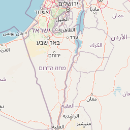
Map view of Ben-Gurion Tomb National Park

Use this park location map to pinpoint Ben-Gurion Tomb National Park in Israel, understand its exact geographic position, and read its mapped placement within the surrounding landscape more clearly.

Pigeon | © OpenStreetMap contributors
Park atlas

Compare desert landscapes and unique protected areas across the Negev Desert region, tracing Israel's diverse conservation geography.

Explore Other National Parks and Protected Areas Near Ben-Gurion Tomb National Park

After exploring Ben-Gurion Tomb National Park, browse other national parks and protected areas across Israel's Negev Desert, mapping diverse landscapes and conservation sites. This structured atlas view provides geographic context for nearby protected areas, allowing for direct comparison of different desert ecosystems and heritage sites.
Watercolor illustration of a canyon with winding river, mountains, and rolling hills
National parkIsrael
About 3.3 km away#1 closest

Southwest

Ein Avdat National Park: A Spectular Desert Oasis and Protected Landscape in Israel

Explore its unique springs, waterfalls, and ancient Nabatean and Byzantine history.

Ein Avdat National Park showcases a rare desert oasis environment, a starkly beautiful protected landscape where natural springs emerge from the Negev's arid terrain. This park is celebrated for its dramatic waterfalls, deep pools, and the preserved remnants of ancient human habitation, including a remarkable Byzantine cave monastery carved directly into the canyon walls. Its geography, shaped by the Nahal Zin wadi, provides a vivid study in desert ecosystems and their capacity for supporting life and history over millennia, making it a key site for understanding landscape context in Israel.

Area
4.8 km²
IUCN
V
Relief
Mixed relief
Climate
Arid
National parkIsrael
About 6.5 km away#2 closest

South

Avdat National Park: A Protected National Park in Israel's Regional Geography

Mapped landscape context and protected area details for Avdat National Park.

Avdat National Park represents a distinct protected landscape entity within the atlas of Israel. This resource focuses on the park's geographic identity, its mapped boundaries, and the surrounding natural terrain. Delve into the specific protected-area attributes that define Avdat National Park and understand its contribution to the country's conservation geography, offering a grounded perspective for geographic exploration.

Climate
Arid
Scope
Terrestrial
Water
No major water
Forest
No forest cover
National parkIsrael
About 15 km away#3 closest

West

Shivta National Park National Park: An Atlas View of Israel's Protected Landscapes

Mapped terrain and regional geographic context for Shivta National Park.

Shivta National Park represents a key protected area, offering a focused entry into Israel's broader geographic and landscape atlas. This page provides specific details about the park's identity as a national park, its mapped terrain, and its placement within the regional context of the country. Users can explore the structured information that defines Shivta National Park's role as a protected landscape, contributing to a deeper understanding of its geographic significance and mapped features.

Climate
Arid
Access
Easy access
Scope
Terrestrial
Water
No major water
National parkIsrael
About 31 km away#4 closest

South

Makhtesh Ramon National Park: Israel's Premier Erosion Cirque & Geological Wonder

Discover dramatic desert terrain and ancient, colorful rock formations.

Makhtesh Ramon National Park in Israel's Negev Desert is the world's largest erosion cirque, a vast 40-kilometer depression revealing millions of years of geological history. Its striking landscape features colorful clay hills, ancient volcanic remnants, fossil beds, and unique sandstone formations, making it an unparalleled destination for understanding Earth's past through its protected natural terrain. Explore the mapped boundaries and regional context of this extraordinary desert formation.

Relief
Mountain
Climate
Arid
Access
Moderate access
Scope
Terrestrial
Watercolor illustration of rolling green hills, a body of water, and grassy vegetation under a light sky.
National parkIsrael
About 33 km away#5 closest

Northeast

Mamshit National Park: Ancient Nabataean City, Byzantine Ruins, and Negev Desert Landscape

Explore exceptionally preserved Nabataean urban architecture and regional geography.

Mamshit National Park offers a rare window into ancient desert urbanism, preserving an exceptionally intact Nabataean caravan city and Byzantine settlement in Israel's Negev Desert. The site showcases unique residential compounds and religious structures, demonstrating sophisticated architectural traditions and water management systems against a backdrop of striking natural terrain. As a vital component of the Incense Road heritage, Mamshit provides rich context for understanding ancient trade, regional geography, and the enduring human adaptation to arid landscapes.

IUCN
V
Relief
Lowland
Climate
Arid
Scope
Terrestrial
National parkIsrael
About 44 km away#6 closest

North

Tel Be'er Sheva National Park: Mapped Boundaries and Protected Landscape Identity

Discover its geographic context within Israel's natural terrain.

This MoriAtlas detail page for Tel Be'er Sheva National Park provides focused insights into its identity as a protected landscape. Users can explore its specific geographic setting within Israel, understand its mapped boundaries, and gain a clearer appreciation for its natural terrain. The content is designed to support detailed atlas-based discovery, offering a comprehensive view of the park's protected area characteristics and regional geographic significance.

National parkIsrael
About 58 km away#7 closest

Northeast

Tel Arad National Park: Discover Israel's Protected Landscape and Mapped Geography

Explore protected area boundaries and regional terrain context.

Delve into Tel Arad National Park, a key protected area in Israel offering insights into its unique landscape and geographic setting. This park provides a focal point for understanding protected land distribution, mapped terrain features, and the regional natural context within the Levant. Utilize this atlas entry to explore the park's specific geographic identity and conservation significance.

Watercolor illustration showing a winding river through green hills with distant trees under a light sky
National parkIsrael
About 58 km away#8 closest

Northwest

Eshkol National Park: Desert Wetland Oasis with Archaeological Significance in Southern Israel

Mapped protected area featuring Ein HaBesor spring and Besor valley landscapes.

Eshkol National Park showcases a rare desert wetland environment sustained by the significant Ein HaBesor spring in Israel's Northern Negev. This protected natural area offers a distinctive landscape where water nourishes lush vegetation against the backdrop of arid terrain. Beyond its ecological value, the park encompasses archaeological remnants, including the mound of Khirbet Shalala, providing a rich geographical and historical discovery context within the Besor Stream basin.

Area
3.54 km²
Relief
Lowland
Climate
Arid
Access
Easy access

Common questions about visiting, size, designation, and location context for Ben-Gurion Tomb National Park

Ben-Gurion Tomb National Park FAQs for park facts, access, geography, and protected area context

Find quick answers about Ben-Gurion Tomb National Park, including protected-area facts, park geography, trail and visitor context, and how the park fits into its surrounding country and regional landscape.
MoriAtlas Explorer

Continue Your Protected Areas Search Across the Global Atlas

Deepen your exploration by continuing the structured search for national parks and protected areas worldwide. Utilize the comprehensive filtering capabilities to compare different conservation landscapes and refine your understanding of global park geography. Discover more about the distribution and characteristics of protected natural areas.

Global natural geography