Mori Atlas logo
Protected areaBenbane Head

A detailed look at the physical boundaries and regional terrain of this protected northern landmark

Benbane Head Protected Area: Geographic Context and Mapped Landscape in County Antrim

(Rezerwat przyrody Mszar)

Benbane Head is a recognized protected area situated along the coastal geography of County Antrim. This site serves as a vital anchor within the local natural landscape, offering a clearly defined boundary that reflects the regional environmental character of Northern Ireland. MoriAtlas provides a mapped reference for this area, allowing for a better understanding of its position within the broader county terrain and its specific role as a protected geographic entity.

peatlandbogSphagnum mossbog pinerare plantsmunicipal forest

Benbane Head

Protected area

Park overview

Structured park overview, official facts, and landscape profile for Mszar Nature Reserve

Mszar Nature Reserve park facts, protected area profile, and essential visitor context

Review the core facts for Mszar Nature Reserve, including designation, size, terrain, visitor scale, habitats, and operating context in one park-focused overview.

About Mszar Nature Reserve

Mszar Nature Reserve is a strict peatland reserve located within the Las Miejski, the municipal forest of the city of Olsztyn in northeastern Poland. Though the reserve covers only a few hectares, it safeguards a complete, well-defined peat-forming basin that originated as a former lake and gradually filled with organic deposits over time. Today, the peat layer in the basin averages around 13 meters thick, illustrating the long ecological history of the site.

The reserve sits within the Olsztyn Lake District, a landscape of post-glacial lakes, moraines, and mixed forests. The peat basin itself lies on a gentle elevation above the water level of nearby Jezioro Długie, surrounded by managed woodland that provides both forest context and a degree of buffering from outside disturbance.

Legally, Mszar was first protected in 1907, long before it received its modern strict-reserve designation. The site was reclassified and formally designated as a strict peatland reserve through legislation dated 30 December 1953, confirming its long-recognized scientific and conservation value. Although small in area, the reserve plays an outsize role in regional botanical research, in part because of the contrast between its undisturbed bog communities and the actively managed forest that surrounds it.

Quick facts and research context for Mszar Nature Reserve

Mszar is a strict peatland nature reserve (ścisły rezerwat torfowiskowy) within the city of Olsztyn, in Poland's Warmian-Masurian Voivodeship. It occupies an enclosed, formerly lakefilled basin inside Las Miejski, the city's municipal forest, where peat has accumulated to an average thickness of roughly 13 meters.

Although only about 5 hectares in extent, the reserve has been legally protected since 1907 and was formally established in its current strict reserve category on 30 December 1953. Its botanical importance lies in the presence of characteristic bog communities and several rare or protected plant species tied to peatland habitats.

Protection and recognition

Documented terrestrial conservation scope and official designation records

Benbane Head Protection Status and International Recognition Data

Terrestrial protection records for Benbane Head outline the documented conservation scope and administrative management framework. Official designation history and international recognition sources provide clear context for ongoing habitat preservation.

Protection details

Protection scope
Terrestrial
Transboundary protection
No
Park context

Deeper park guide and search-rich context for Mszar Nature Reserve

Mszar Nature Reserve history, landscape, wildlife, and travel context

Explore Mszar Nature Reserve through its history, landscape character, ecosystems, wildlife, conservation priorities, cultural context, and seasonal travel timing in a structured park guide built for atlas discovery and search intent.

Why Mszar Nature Reserve stands out

Mszar is best known for its well-developed peatland vegetation communities, especially assemblages of bog pines and Sphagnum mosses typical of raised and transitional bogs. The reserve protects stands that include Vaccinio uliginosi-Pinetum and Ledo-Sphagnetum magellanici communities, along with a notable suite of bog specialists such as Labrador tea, bog rosemary, crowberry, two sundew species, and cottongrass. The site's compact size and its integration into a managed urban forest make it a significant reference locality for peatland conservation and species inventory work in northern Poland.

Mszar Nature Reserve history and protected-area timeline

Peatland protection at Mszar has a longer history than its current reserve designation suggests: the site was already protected in some form as early as 1907. The reserve in its present legal form was established on 30 December 1953, when it was designated as a ścisły rezerwat torfowiskowy, a strict peatland nature reserve, through an official act published in the Polish legal monitor.

The original designation act reported a slightly smaller area than the currently recognized size, with later measurements confirming the reserve's surface at roughly 5.24 hectares. Beyond the legal milestones, the reserve has served as a subject of repeated scientific inventories, particularly of its lichen flora: surveys at the turn of the 20th and 21st centuries documented 42 lichen species, while a 2024 inventory recorded 71 species, although not all earlier species were reconfirmed in the later survey. This combination of early protected status and ongoing scientific attention has shaped Mszar's identity as both a conservation site and a reference locality for peatland study in the Warmian-Masurian region.

Mszar Nature Reserve landscape and geographic character

Mszar occupies a shallow, internally drained basin set within the broader Olsztyn Lake District. Geomorphologically, the site represents a classic post-glacial hollow that originally held open water and has since been infilled by organic deposits, producing a peat-filled depression rather than a standing lake.

The peatland surface sits at roughly 115 meters in elevation, a few meters above the water level of neighboring Jezioro Długie, which lies at about 103.6 meters. Surrounding terrain consists of forested morainic ground typical of the Warmian-Masurian landscape, where managed woodland transitions into the wet, boggy core of the reserve. The deeply concave shape of the basin and the depth of accumulated peat give the site a clearly defined physical identity within the surrounding forest.

Mszar Nature Reserve ecosystems, habitats, and plant life

Ecologically, Mszar is defined by its peatland plant communities. Two community types anchor the reserve's vegetation: Vaccinio uliginosi-Pinetum, a bog-pine woodland community, and Ledo-Sphagnetum magellanici, a Sphagnum-rich magellanic bog community. Together they define the vegetation character of the reserve.

The moss layer is built from Sphagnum species, including Sphagnum warnstorfii and Sphagnum nemoreum, alongside other bryophytes such as Bryum pseudotriquetrum. These mosses create the carpet typical of active peatland. Above this layer grows a cohort of characteristic bog vascular plants, including marsh Labrador tea (Ledum palustre), bog rosemary (Andromeda polifolia), crowberry (Empetrum nigrum), round-leaved sundew (Drosera rotundifolia), long-leaved sundew (D. anglica), sheathed cottongrass (Eriophorum vaginatum), and Polystichum aculeatum.

The reserve has also been the subject of detailed lichen inventories. Surveys at the turn of the 20th and 21st centuries documented 42 lichen species, and a 2024 inventory increased the documented total to 71 species, illustrating both the richness of the site and the dynamic nature of its non-vascular flora.

Mszar Nature Reserve wildlife and species highlights

While the reserve's profile is primarily botanical, Mszar has also supported targeted faunal studies. Early zoological work examined the ant fauna of the peatland, documenting the assemblage of Formicidae present on the site, and parallel studies surveyed the bird life of the broader suburban Las Miejski, including the Mszar and Redykajny reserves.

The surrounding managed forest, combined with the reserve's wet interior, provides habitat for typical woodland and peatland-associated bird species. The bog vegetation and pools of the reserve also create conditions for invertebrates characteristic of peatland habitats, even if detailed modern wildlife inventories have been less extensively reported than the site's botanical work.

Mszar Nature Reserve conservation status and protection priorities

Mszar is significant from a conservation standpoint because it preserves a representative example of peatland vegetation in a region that has otherwise seen extensive drainage and modification of wetlands. Its strict-reserve status, paired with a long history of legal protection dating back to 1907, gives it a stronger and longer track record of statutory safeguarding than many comparable sites.

The reserve's compact size concentrates high ecological value into a small area, making the surrounding forest buffer critical to its continued integrity. Repeated lichen inventories, in particular, suggest ongoing scientific monitoring and a sustained interest in tracking biodiversity change over time. As such, Mszar functions both as a refuge for peatland specialists and as a long-term reference site for bog conservation in northern Poland.

Top sights and standout views in Mszar Nature Reserve

Mszar's core distinction is its peatland character: a thick, lake-derived peat deposit hosting classic bog-pine and Sphagnum communities. The reserve's strict protection status, granted in 1953 and building on earlier protection from 1907, gives it a particularly long legal heritage for a site of its size.

Its location inside an urban municipal forest also makes it a notable example of strictly protected peatland habitat embedded directly within a city green space. The repeated lichen inventories, which have grown from 42 to 71 documented species in later surveys, point to the site's continued use as a monitoring reference for bog biodiversity.

Best time to visit Mszar Nature Reserve

Because Mszar is a strict nature reserve with a focus on ecological protection rather than visitor infrastructure, informal seasonal visitation is typically influenced by bog conditions rather than by curated access. In general, late spring and summer are biologically the most active periods, when Sphagnum and bog shrubs are at their most developed and characteristic peatland plants are identifiable. Autumn can offer quieter conditions and softer light across the surrounding forest, while winter, though cold, exposes the basin's structure within the woodland.
Monthly climate preview

Review measured monthly weather averages and baseline meteorological data for County Antrim

Benbane Head Climate Normals: Long Term Temperature and Precipitation Patterns

Representative coordinates record annual shifts in mean temperature and precipitation across twelve measured periods. Examining the complete monthly climate profile reveals detailed thermal ranges and baseline normals for the protected landscape.
Annual mean9 °C
5 °C14 °C
Jan
Feb
Mar
Apr
May10°
Jun13°
Jul14°
Aug14°
Sep13°
Oct10°
Nov
Dec
Warmest month
August

14.3 °C

Coolest month
January

5.1 °C

Wettest month
November

3.9 mm/day

Driest month
May

2.4 mm/day

Park location guide

Geography guide, regional context, and park location map for Mszar Nature Reserve

Mszar Nature Reserve park geography, regions, and map view in United Kingdom

Understand where Mszar Nature Reserve sits in United Kingdom through a broader geographic reading of the surrounding landscape, nearby location context, and its mapped position within the national park landscape.

How Mszar Nature Reserve fits into United Kingdom

The United Kingdom is a parliamentary constitutional monarchy located in northwestern Europe, consisting of four constituent countries: England, Scotland, Wales, and Northern Ireland. As a major global power with over 69 million residents, it maintains significant international influence in politics, economics, and culture.

Wider geography shaping Mszar Nature Reserve in United Kingdom

The United Kingdom is an island nation located in northwestern Europe, surrounded by the Atlantic Ocean, North Sea, English Channel, Celtic Sea, and Irish Sea. It shares a land border with the Republic of Ireland to the west. The territory includes the island of Great Britain, the northeastern portion of Ireland, and most of the smaller British Isles islands.

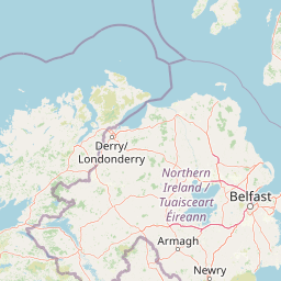
Map view of Mszar Nature Reserve

Use this park location map to pinpoint Mszar Nature Reserve in United Kingdom, understand its exact geographic position, and read its mapped placement within the surrounding landscape more clearly.

Pigeon | © OpenStreetMap contributors

Location context for Mszar Nature Reserve

County AntrimNorthern Ireland
Park atlas

Continue exploring connected regional landscapes and nearby protected terrain

Parks Near Benbane Head and Other Protected Areas in the Surrounding Region

Browsing nearby national parks and protected areas around Benbane Head reveals connected regional terrain and varied coastal ecosystems. Expanding the geographic comparison helps trace wider conservation landscapes and adjacent habitats across the surrounding territory.
Protected areaCounty Antrim
About 29 km away#1 closest

Southeast

Slieveanorra Forest Protected Area: Geography, Maps, and Upland Landscape Context

A comprehensive look at the Antrim forest and glacial landscape.

Slieveanorra Forest serves as a prominent protected area within the County Antrim uplands. Featuring expansive conifer woodlands, the site includes rugged terrain, reservoir edges, and scenic summit views. Understand the geological and environmental composition of this working forest landscape through its mapped boundaries and regional context.

Relief
Upland
Water
Minor water
Nature reserveCounty Londonderry
About 36 km away#2 closest

Southwest

Roe Estuary Nature Reserve: Coastal Geography and Protected Estuarine Landscapes

Lough Foyle coastal terrain in County Londonderry

Explore the structured geography of Roe Estuary Nature Reserve, a primary coastal protected area in County Londonderry. This atlas entry details the reserve's intertidal mudflats, salt marshes, and riverine channels. Understand its unique position between the Binevenagh escarpment and the waters of Lough Foyle, highlighting its role as a vital corridor for migratory species and aquatic life within the Northern Ireland coastal landscape.

Relief
Lowland
Climate
Temperate
Access
Access unknown
Scope
Mixed
Nature reserveNorthern Ireland
About 48 km away#3 closest

South

Ballynahone Bog: Northern Ireland Lowland Raised Peatland and Wetland Geography

Intact active bog dome and protected wetland landscape

Examine the geography of Ballynahone Bog, one of the largest remaining lowland raised bogs in Northern Ireland. This protected landscape preserves an active peat-forming surface, intricate hummock and pool complexes, and marginal fen habitats, offering insight into the ecological history and hydrological patterns of the Lough Neagh lowland region.

Area
2.432 km²
Established
1995
Relief
Lowland
Climate
Temperate
Nature reserveNorthern Ireland
About 50 km away#4 closest

South

Lough Beg Nature Reserve: Mapping the Wetlands and Floodplains of Northern Ireland

An essential protected landscape within the Lough Neagh basin.

Lough Beg provides a distinct geographic study of freshwater ecosystems and alluvial landscapes. As a designated nature reserve, it forms a crucial link in the Lower Bann catchment, characterized by its shallow waters and seasonal pasture flooding. The area serves as a primary hub for migratory bird species, while the historic Church Island offers a unique convergence of early Christian heritage and natural wetland terrain.

Relief
Lowland
Climate
Temperate
Access
Easy access
Scope
Terrestrial
Nature reserveNorthern Ireland
About 85 km away#5 closest

South

Oxford Island National Nature Reserve: Protected Wetland Landscapes of Northern Ireland

Lakeshore habitats and woodland geography at Lough Neagh

Oxford Island is a prominent nature reserve where terrestrial woodland meets the expansive waters of Lough Neagh. The site showcases a transition of reed beds and meadows that serve as vital ecological assets within the regional geography of Northern Ireland, offering a dense, accessible look at lowland wetland environments.

Area
1.14 km²
Relief
Lowland
Climate
Temperate
Access
Easy access
A soft watercolor illustration featuring green rolling hills; pink foliage; and a calm bay under a pale sky.
Marine protected areaScotland
About 92 km away#6 closest

East

Lamlash Marine Protected Area: Coastal Geography and Protected Waters in Scotland

Maritime terrain and conservation landscapes of the Firth of Clyde

Located along the eastern coast of the Isle of Arran, the Lamlash Marine Protected Area serves as a landmark for community-led conservation in Scotland. The site protects a vital marine ecosystem including maerl beds within a sheltered natural harbour, providing a distinct study of coastal boundaries and marine terrain facing Holy Isle across the Firth of Clyde.

Established
2008
Visitors
1.1K annual
Relief
Lowland
Climate
Temperate
Watercolor illustration of a mountainous landscape with a lake and forests
National parkCounty Donegal
About 93 km away#7 closest

West

Glenveagh National Park: A Protected Landscape in the Heart of County Donegal

Mapped geography and natural terrain for Ireland's national park.

Delve into the geographic specifics of Glenveagh National Park, a protected area situated in County Donegal. This section provides detailed information on its mapped boundaries and regional landscape context. Understand how this national park fits within the natural geography of Ulster, offering a structured atlas view for detailed exploration of its unique terrain and protected status.

Area
169.58 km²
Established
1986
IUCN
II
Relief
Mixed relief
Marine protected areaArgyll and Bute
About 96 km away#8 closest

Northeast

Loch Sween Marine Protected Area: Coastal Geography and Regional Atlas Map

A distinctive sea loch ecosystem in Argyll and Bute.

Investigate the coastal topography and protected marine boundaries of Loch Sween. This sea loch is defined by its irregular branching inlets and islands, creating a unique habitat mosaic of maerl beds and burrowed mud within the broader context of the western Scottish coastline.

Area
41 km²
Established
2014
IUCN
IV
Access
Access unknown

Common questions about visiting, size, designation, and location context for Mszar Nature Reserve

Mszar Nature Reserve FAQs for park facts, access, geography, and protected area context

Find quick answers about Mszar Nature Reserve, including protected-area facts, park geography, trail and visitor context, and how the park fits into its surrounding country and regional landscape.
MoriAtlas Explorer

Continue Your Protected Areas Search Across the Global Atlas

Deepen your exploration by continuing the structured search for national parks and protected areas worldwide. Utilize the comprehensive filtering capabilities to compare different conservation landscapes and refine your understanding of global park geography. Discover more about the distribution and characteristics of protected natural areas.

Global natural geography