
Beaches
Park geography
Detailed spatial analysis of coastal cliffs, elevation ranges, and natural land features.
Beowa National Park Geographic Profile, Mapped Boundaries, and Terrain Classification
Beowa National Park spans 104.86 square kilometers of diverse coastal terrain in New South Wales, Australia. This geographic profile details the park boundary, identifies key elevation points ranging from sea level to 252 meters, and catalogs major natural features like capes, peaks, and waterways within the protected area.
Related tags
Coastal National ParkNew South WalesSouth CoastHeathlandEucalypt Woodland
Coastal wilderness on the far South Coast of New South Wales
Beowa National Park
Beowa National Park is a coastal protected area in southeastern New South Wales, Australia, situated approximately 578 kilometers south of Sydney along the South Coast region. The park encompasses approximately 105 square kilometers of diverse landscapes spanning both sides of Twofold Bay and the town of Eden. Established in 1971 as Ben Boyd National Park, the park was officially renamed to Beowa in 2022 following recognition of its original namesake's involvement in blackbirding, a historical practice of forced labor. The new name derives from the Thaua language, meaning orca, an animal of deep cultural significance to the traditional Aboriginal owners. The park protects a distinctive combination of heathland-covered headlands, open eucalypt woodlands, scattered rainforest gullies, and dramatic coastal formations including the colorful Pinnacles erosion site.
- Location
- Australia
- Park type
- National park
- Established
- 1971
- Area
- 104.9 km²
- Highest point
- 252 m
Location overview
Regional position and coastal status in New South Wales, Australia
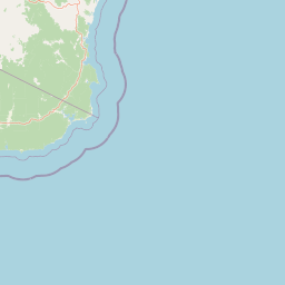
Geographic Location of Beowa National Park in Australia
Beowa National Park lies within the coastal borders of New South Wales, Australia. Regional records establish the official coastal designation and territorial classification of the protected territory.
- Countries
- Australia
- Regions
- New South Wales
- Primary location
- New South Wales
- Geographic setting
- Coastal
Boundary and coordinates
Examining the 104.86 square kilometer territorial footprint and spatial extent
Beowa National Park Boundary Map and Spatial Dimensions
The mapped outline provides vital spatial context for the protected terrain. Regional geographic facts define the land area of 104.86 square kilometers alongside perimeter estimates and coordinate spans.
- Boundary area
- 107.7 km²
- Boundary perimeter
- 145.7 km
- Northernmost point
- 36.9261° S
- Southernmost point
- 37.2637° S
- Easternmost point
- 150.0515° E
- Westernmost point
- 149.8753° E
- Geographic centre
- 37.1358° S, 149.9669° E
- North–south span
- 37.5 km
- East–west span
- 15.7 km
Elevation and terrain
Lowland relief classifications, coastal features, and recorded peaks
Beowa National Park Elevation Summary and Terrain Geography
Beowa National Park records a lowland terrain profile spanning from sea level up to a maximum elevation of two hundred fifty two meters. Recorded natural feature cards detail specific rivers, capes, and beaches situated within the protected landscape boundaries.
- Minimum elevation
- 0 m
- Maximum elevation
- 252 m
- Highest point
- 252 m
Selected named natural features
Capes
North Head
Capes
Green Cape
Bays
Red Rock Bay / Red Sands Bay
0 m
Capes
Pulpit Rock
Rivers
Woodburn Creek
Environmental setting
Temperate climate zones, forest cover, and coastal landforms across the protected terrain
Beowa National Park Environmental Setting and Landscape Classifications
Recorded habitat types and landscape features provide complementary ways to read the physical setting of Beowa National Park. Connected categories link directly to related environmental destinations across the regional park network.
- Relief
- Lowland
- Climate
- Temperate
- Water
- Major water bodies
- Forest cover
- Mostly forested
Landscape features
Coast · Beach · Dunes · Cliffs · Forest · Hills · Valleys
Habitat types
Heath · Shrubland · Temperate broadleaf forest · Coastal habitat · Dune habitat · Grassland
Park atlas
Discover surrounding protected landscapes and trace the regional park geography of the New South Wales South Coast.
Explore Nearby National Parks and Coastal Protected Areas Beyond Beowa National Park
Browse a curated selection of national parks and coastal protected areas located near Beowa National Park, offering diverse landscapes from heathland headlands to eucalypt woodlands. Compare these conservation landscapes to understand the broader regional context of protected areas along Australia's South Coast, tracing their geographic spread and ecological connections.
Nature reserveNew South Wales
About 2.9 km away#1 closest
Northwest

Eagles Claw Nature Reserve: Mapping Coastal Protected Landscapes in New South Wales
Coastal terrain, sea gutters, and penguin nesting habitat
Eagles Claw Nature Reserve is a distinctive protected area on the NSW far south coast, known for its rugged shoreline of sea gutters and low cliffs. The site features dense coastal scrub dominated by bracelet honey myrtle, providing essential nesting shelter for little penguins. This atlas overview details the reserve's topography and its function as a vital coastal sanctuary.
- Area
- 0.01 km²
- Established
- 1986
- IUCN
- IV
- Relief
- Lowland
Nature reserveNew South Wales
About 6.7 km away#2 closest
South
Nadgee Nature Reserve: Protected Wilderness and Coastal Geography in New South Wales
Coastal heath, eucalyptus forest, and regional bird habitat
Located at the southeastern edge of the Australian continent, Nadgee Nature Reserve offers a deep look at remote coastal landscapes. The area protects a mix of saltwater wetlands, dense eucalyptus forests, and significant Aboriginal cultural sites along the coast, creating a contiguous protected zone that stretches across state borders into Victorian territory.
- Area
- 206.71 km²
- Established
- 1957
- IUCN
- Ib
- Relief
- Lowland
National parkNew South Wales
6.8 km away#3 closest
Northwest
South East Forests National Park: New South Wales National Park Atlas Entry
Mapped landscape and protected area geography.
This canonical MoriAtlas entry for South East Forests National Park provides essential geographic context and details about its status as a national park. Understand the mapped boundaries of this protected landscape within New South Wales, supporting discovery through its regional setting and natural terrain. The focus remains on atlas-style exploration of its geographic identity and conservation significance, devoid of visitor logistics or travel advice.
- Area
- 1,151.77 km²
- Established
- 1997
- IUCN
- II
- Relief
- Highland
National parkNew South Wales
9.6 km away#4 closest
North
Bournda National Park: A Protected National Park in New South Wales
Explore mapped boundaries and regional geographic context.
Bournda National Park represents a key protected area within the state of New South Wales, Australia. This page offers focused discovery of its protected landscape identity, situated within the broader geographic framework of the region. Examine the park's mapped boundaries and understand its significance as a component of Australia's network of natural landscapes.
- Area
- 26.55 km²
- Established
- 1947
- IUCN
- II
- Relief
- Lowland
National parkNew South Wales
14 km away#5 closest
West
Mount Imlay National Park: Protected Land Geography and Mapped Boundaries in New South Wales
Explore the geographic context of this Australian national park.
Mount Imlay National Park serves as a significant protected area within New South Wales, providing a focal point for understanding regional geography and mapped natural landscapes. As a national park, its boundaries and terrain offer valuable insights for atlas-based discovery, highlighting Australia's commitment to conserving diverse geographic entities and showcasing its role in the broader national landscape context.
- Area
- 48 km²
- Established
- 1972
- IUCN
- II
- Relief
- Mountain
National parkAustralia
25 km away#6 closest
South
Croajingolong National Park: A UNESCO World Biosphere Reserve with Dramatic Coastal Geography
Explore Victoria's protected wilderness, mapped coastlines, and diverse ecosystems.
Croajingolong National Park is a key protected area in Victoria, Australia, recognized globally as a UNESCO World Biosphere Reserve. This vast national park offers a detailed look at coastal wilderness, characterized by its extensive sandy beaches, rugged rocky headlands, dynamic dunes, and rich heathland ecosystems. Its position along the Tasman Sea coastline provides significant geographic context, forming a vital part of southeastern Australia's protected landscapes and offering unique opportunities for atlas-driven exploration of its mapped terrain and biodiversity.
- Area
- 883.55 km²
- Established
- 1979
- IUCN
- II
- Relief
- Mixed relief
National parkNew South Wales
26 km away#7 closest
North
Mimosa Rocks National Park: Coastal Protected Area Atlas and Geographic Discovery
New South Wales National Park with Mapped Coastal Terrain
Mimosa Rocks National Park offers a compelling glimpse into Australia's protected coastal geography. This national park showcases a dynamic landscape where rocky outcrops and sweeping beaches define the Sapphire Coastline within New South Wales. Engage with its mapped boundaries and understand its role as a vital part of the regional protected area network, perfect for detailed atlas exploration and appreciating natural landscape context.
- Area
- 57 km²
- Established
- 1973
- IUCN
- II
- Relief
- Lowland
Marine protected areaAustralia
28 km away#8 closest
South
Cape Howe Marine National Park: Victoria's Southeastern Marine Protected Landscape
Rugged coast, Southern Ocean influence, and marine conservation.
Cape Howe Marine National Park offers a protected marine environment at the remote eastern edge of Victoria, Australia. Defined by its dramatic coastal geography, the park features rocky headlands, exposed cliffs, and waters influenced by the powerful Southern Ocean. Established in 2002, this marine protected area contributes to a significant continuum of protected lands, adjacent to terrestrial national parks. Its landscape is shaped by powerful surf and coastal wilderness, providing a unique example of marine conservation where the Australian continent meets the open ocean.
- Area
- 40.5 km²
- Established
- 2002
- IUCN
- II
- Climate
- Temperate
MoriAtlas Explorer
Continue Exploring Beowa National Park's Mapped Landscapes and Geography
Understand the full geographic scope and protected-area identity of Beowa National Park by continuing your atlas exploration. Discover the mapped terrain, coastal formations, and regional context that define this significant national park, offering a concrete foundation for understanding Australian protected landscapes.
Browse next
Global natural geography
Explore related park routes
Explore MoriAtlas Global ParksBrowse All MoriAtlas ParksGlobal Park Map DiscoveryMoriAtlas: Browse All CountriesBrowse All MoriAtlas ContinentsNational Park Environment AtlasGrand Canyon National Park AtlasYellowstone National Park AtlasYosemite National Park Atlas and GeographySerengeti National Park AtlasGalápagos National Park Protected LandscapeBanff National Park Geography and AtlasKruger National Park Atlas EntryUluṟu-Kata Tjuṯa National Park AtlasExplore Uluru-Kata Tjuta National Park GeographyPlitvice Lakes National Park AtlasFiordland National Park Protected LandscapeGreat Smoky Mountains National Park AtlasAfghanistan National Parks and Protected AreasAlbania National Parks and Protected AreasAlgeria National Parks and Protected AreasAmerican Samoa National Parks and Protected AreasAndorra National Parks and Protected AreasAngola National Parks and Protected AreasAntarctica National Parks and Protected AreasAntigua and Barbuda Park List