Mori Atlas logo
National parkBiogradska Gora

Mapping the Bjelasica mountain range, glacial lake systems, and ancient beech forest ecosystems

Biogradska Gora National Park: A Deep Geographic Atlas of Montenegro's Primeval Forest Landscapes

(Biogradska Gora National Park)

Biogradska Gora National Park represents a significant protected landscape in central Montenegro, centered on the Bjelasica mountain massif. This area contains one of Europe's last remaining virgin beech forests and a series of high-altitude glacial lakes, creating a complex mountain terrain between the Tara and Lim rivers. The geography encompasses everything from dense temperate rainforests at lower elevations to rugged alpine ridges that define the park's protected boundaries.

virgin forestbeech forestglacial lakesmountain landscapeBjelasicabiosphere reserve

Biogradska Gora

National park

Park overview

Structured park overview, official facts, and landscape profile for Biogradska Gora

Biogradska Gora park facts, protected area profile, and essential visitor context

Review the core facts for Biogradska Gora, including designation, size, terrain, visitor scale, habitats, and operating context in one park-focused overview.

About Biogradska Gora

Biogradska Gora is a compact yet ecologically rich national park set on the Bjelasica massif in central Montenegro. It lies between the Tara and Lim rivers and falls within the municipalities of Kolašin, Berane, and Mojkovac, positioning it at the geographic crossroads of northern Montenegro's mountain interior. With roughly 54 square kilometers of protected area, it is the smallest of Montenegro's five national parks, yet it preserves several distinct landscape layers that together form one of the country's most valuable natural reserves.

The defining feature of the park is its 16-square-kilometer virgin forest, Biogradska Gora, a surviving old-growth temperate woodland surrounding Biogradsko Lake at the park's entrance. This ancient forest, dominated by European beech with sycamore maple and European ash around the lake and silver fir on the slopes, contains trees that are more than five centuries old. It is widely regarded as one of the last primeval beech forests in Europe and is the reason the area has attracted protection and scientific attention for generations.

Beyond the forest, Biogradska Gora extends upward into the rugged terrain of Bjelasica, with mountain slopes and summits exceeding 2,000 meters. Scattered across this high country are six glacial lakes, including a cluster of five lakes at around 1,820 meters elevation, traditionally named Šiško, Mali Šiško, Ursulovačko, Pešica, and Ševarina, along with the lowland Biogradsko Lake. The combination of steep mountain ridges, glacial basins, meandering streams, green pastures, and clear reflective lakes gives the park a layered scenic character unusual even within the Balkans.

Biogradska Gora has earned international recognition beyond its national designation. UNESCO has included the park in its World Network of Biosphere Reserves as part of the Man and the Biosphere Programme, and has additionally identified it as an Important Plant Area, an Important Fungus Area, and an Important Bird Area. These designations reflect not only its botanical richness but also its significance as a refugial habitat for endemic and rare species, making it a center of biological diversity for both the Balkan Peninsula and broader Europe.

Culturally, the park is intertwined with the pastoral heritage of Bjelasica. Traditional wooden shepherd huts known as katuns, scattered across the high meadows, reflect centuries of seasonal grazing practice that continues to shape the cultural landscape of the area. Combined with sacred monuments and archaeological localities found throughout the park, this human dimension adds depth to Biogradska Gora's identity as a place where nature protection and traditional mountain life coexist.

Quick facts and research context for Biogradska Gora

Biogradska Gora National Park is located in the Bjelasica mountains of central Montenegro, between the Tara and Lim rivers, and is administered from Kolašin municipality. Although it is the smallest of Montenegro's five national parks, it protects roughly 54 square kilometers of mountain terrain and forest.

The park combines high ridge landscapes above 2,000 meters, six glacial lakes, swift mountain streams, and a 16-square-kilometer virgin forest that is among the last of its kind in Europe. It has been a national park since 1952 and was included in UNESCO's Man and the Biosphere Programme in 1977, also being recognized as an Important Plant Area, Important Fungus Area, and Important Bird Area.

Protection and recognition

Documented terrestrial conservation scope and recognition history

Biogradska Gora Protection Status and Designated Area History

Biogradska Gora establishes terrestrial protection in 1977 through documented conservation records and historical designation data. Conservation facts bring together official management scope and international recognition status for accurate geographic evaluation.

Protection details

Protection scope
Terrestrial
Designated year
1977
Transboundary protection
No
Park context

Deeper park guide and search-rich context for Biogradska Gora

Biogradska Gora history, landscape, wildlife, and travel context

Explore Biogradska Gora through its history, landscape character, ecosystems, wildlife, conservation priorities, cultural context, and seasonal travel timing in a structured park guide built for atlas discovery and search intent.

Why Biogradska Gora stands out

Biogradska Gora is best known for its 16-square-kilometer virgin beech forest, one of the last surviving old-growth temperate forests in Europe and the defining feature around which the park was established. Surrounding Biogradsko Lake, this ancient woodland contains trees over five hundred years old, primarily European beech, sycamore maple, and European ash near the lake, with silver fir on the slopes above. The park is equally recognized for its glacial lake system on Bjelasica mountain, including Biogradsko Lake in the heart of the forest and five higher-altitude lakes around 1,820 meters elevation. Combined with the heavy rainfall that supports temperate rainforest conditions, these glacial and forest features give Biogradska Gora its identity as both a mountain park and a primeval forest reserve.
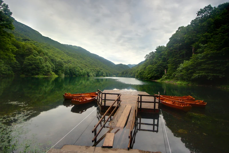
A wooden dock on a quiet lake at Biogradska Gora with several small orange rowboats moored to it, set against a backdrop of lush green forested mountains under a cloudy sky.
A wooden pier extending into the calm, reflective waters of Biogradsko Lake, surrounded by the dense, temperate forests of Biogradska Gora National Park.

Biogradska Gora history and protected-area timeline

The history of protection at Biogradska Gora stretches back to the late nineteenth century, when the area of Kolašin was liberated from Ottoman rule in 1878. In gratitude, local people from the Morača and Rovca tribes presented a portion of the forest to King Nikola I Petrović-Njegoš of Montenegro. That gift forest, known as Branik Kralja Nikole, became an early protected natural reserve under royal patronage and represents the original seed of what would later become the modern national park.

Nearly seventy years after that initial protection, Biogradska Gora was formally proclaimed a national park in 1952, establishing the legal and institutional framework that continues to govern the area today. Its unique combination of virgin forest, glacial lakes, and mountain terrain placed it among the earliest formally designated protected landscapes of the region.

International recognition followed in 1977, when UNESCO included the park in its Man and the Biosphere Programme, embedding Biogradska Gora within a global network of biosphere reserves and confirming its importance well beyond Montenegro. This international designation has supported ongoing scientific research and conservation management, while also reinforcing the park's reputation as a reference site for European forest conservation.

The broader region around the park also carries significant historical weight. Nearby Kolašin was the site of the 1858 Battle of Kolašin between Montenegrin forces and the Ottoman Empire, and the area saw further conflict during the First Balkan War of 1912. During World War II, the Bjelasica region served as a center of partisan activity. While these events took place outside the strict boundaries of the national park, they shape the cultural memory and historical context in which Biogradska Gora is situated.

Biogradska Gora landscape and geographic character

The landscape of Biogradska Gora is shaped by the Bjelasica massif, a central-Montenegrin mountain range that rises in sweeping ridges and broad slopes above the surrounding river valleys. The terrain transitions from gentler forested lowlands near the park entrance to high mountain country where summits exceed 2,000 meters, producing a layered topography that defines the visual rhythm of the park.

Glacial processes have left a clear imprint on the landscape. Six glacial lakes are scattered across the park, ranging from Biogradsko Lake in the heart of the virgin forest to a cluster of five higher lakes, traditionally named Šiško, Mali Šiško, Ursulovačko, Pešica, and Ševarina, perched at around 1,820 meters elevation. These lakes, together with fast-moving mountain streams, valleys, and clear-edged ridges, create a distinctive high-mountain scenery that contrasts with the closed canopy of the forest below.

The very high rainfall of the area, averaging up to around 100 inches per year, sustains dense vegetation and gives parts of Biogradska Gora a temperate rainforest character unusual for the region. The interplay of mature forest, open meadows, reflective lakes, and rugged ridgelines makes the park visually varied: visitors moving from the entrance upward through the forest and onto the Bjelasica heights encounter an unusually complete sequence of Balkan mountain landscapes within a single protected area.
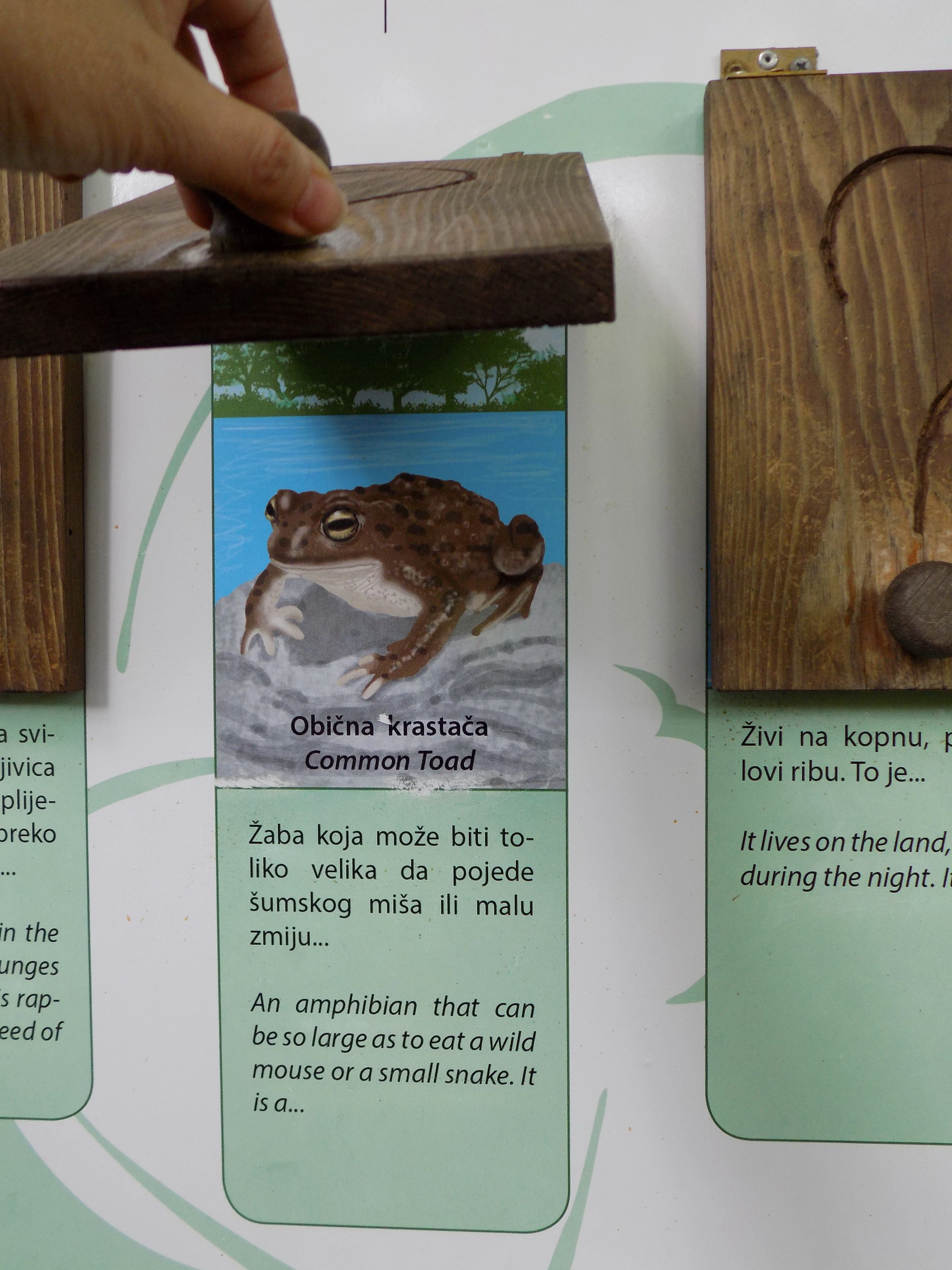
A close up view of an interactive educational sign in a park, showing a picture of a common toad and text in both Serbian and English, with a wooden flap being lifted by a hand.
An educational display in Biogradska Gora National Park featuring facts about the Common Toad.

Biogradska Gora ecosystems, habitats, and plant life

Although it is the smallest of Montenegro's national parks, Biogradska Gora supports an exceptionally diverse range of ecosystems and habitats within its 54 square kilometers. Twenty-six distinct plant habitats have been identified, encompassing roughly 220 plant species and 86 species of trees and shrubs. This habitat diversity, combined with the dramatic elevation gradient from lowland forest to alpine ridges, creates layered ecological zones that shift from dense temperate broadleaf and mixed forest in the valleys to montane and subalpine communities higher up.

The park's ecological identity is anchored by its 16-square-kilometer virgin forest, a remnant old-growth woodland that has developed without major human disturbance for centuries. This forest is dominated by European beech along with sycamore maple and European ash around Biogradsko Lake, with silver fir prominent on the slopes. Such ancient beech forests are exceedingly rare in Europe, and Biogradska Gora is recognized as one of the continent's most important refugia for this habitat type.

UNESCO has acknowledged the park as an Important Plant Area and an Important Fungus Area, highlighting the presence of endemic and rare species as well as a notable fungal community. The combination of refugial habitat conditions, high rainfall, varied terrain, and intact forest cover has allowed numerous species of conservation interest to persist here, making the park a center of plant diversity for the Balkans and for Europe as a whole.
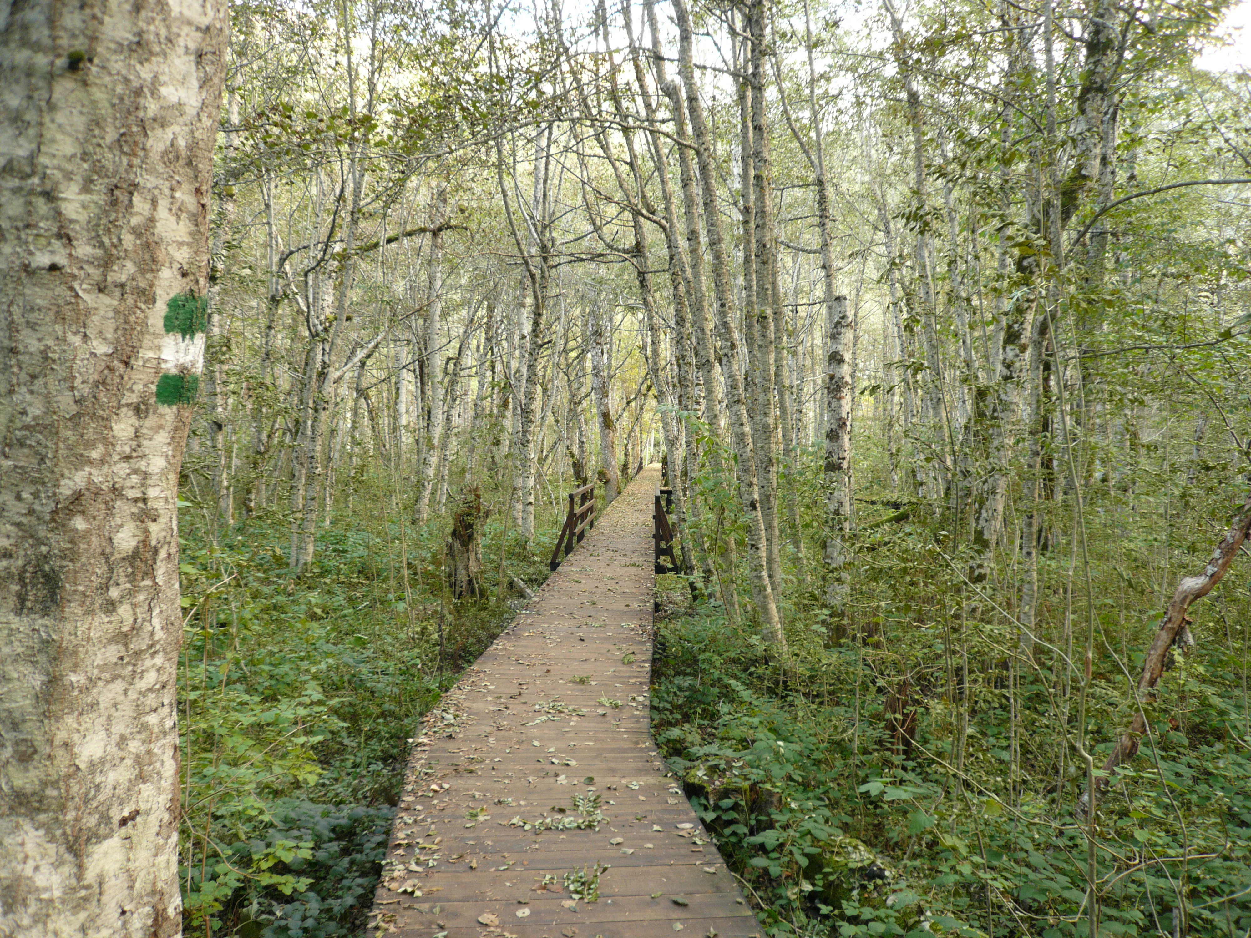
A wooden boardwalk path leads through a lush, deciduous forest with thin tree trunks and green undergrowth. A green and white trail marker is visible on a tree in the foreground.
A wooden boardwalk trail winds through the dense forest surrounding Biogradsko Lake.

Biogradska Gora wildlife and species highlights

The wildlife of Biogradska Gora is shaped by the park's exceptional habitat diversity, which supports a rich community of animals across forest, meadow, lake, and alpine zones. Roughly 150 bird species have been recorded in and around the park, a level of avian diversity that has earned it recognition from UNESCO as an Important Bird Area. The combination of intact old-growth forest, glacial lakes, and high mountain pastures provides nesting, feeding, and migratory habitat for a wide spectrum of birdlife.

Around ten mammal species inhabit the park, using the forest cover and mountain terrain for shelter and movement throughout the year. Aquatic life is also present in the park's lakes and streams, with three species of trout recorded in its waters alongside roughly 350 insect species, contributing to a complex freshwater food web. The relatively undisturbed nature of Biogradska Gora, particularly within its virgin forest core, allows these animal communities to function with a degree of continuity unusual in heavily modified European landscapes.

Biogradska Gora conservation status and protection priorities

Biogradska Gora holds a distinctive place in European conservation as the protector of one of the continent's last remaining virgin forests, an old-growth beech ecosystem spanning roughly 16 square kilometers. The protection of this primeval woodland is the single most significant conservation legacy of the park, anchoring both its national and international importance.

The park has been nationally protected since 1952 and internationally recognized since 1977 through its inclusion in UNESCO's Man and the Biosphere Programme as part of the World Network of Biosphere Reserves. This dual layer of protection frames Biogradska Gora as both a nationally governed nature reserve and a globally monitored biosphere site, supporting research, monitoring, and management aimed at preserving its ecological integrity.

UNESCO has further identified Biogradska Gora as an Important Plant Area, an Important Fungus Area, and an Important Bird Area, reflecting its importance across multiple branches of natural heritage. The park functions as a refugium for endemic and rare plant and animal species, and as a center of diversity for flora and fauna of the Balkan Peninsula. Together, these designations position Biogradska Gora as a key reference site for temperate forest, mountain, and freshwater conservation in southeastern Europe.

Biogradska Gora cultural meaning and human context

The cultural landscape of Biogradska Gora is closely tied to the pastoral traditions of the Bjelasica highlands. Traditional wooden shepherd dwellings known as katuns are scattered across the park's meadows and high pastures, remnants of a seasonal grazing economy that has shaped human presence in the mountains for generations. These katuns remain emblematic of the relationship between local communities and the protected landscape.

The park's surroundings also carry significant cultural and historical depth. The wider region around Kolašin holds sacred monuments, traditional rural architecture, and archaeological sites, while nearby landmarks and historical battlefields reflect centuries of regional history, including resistance to Ottoman rule, the Balkan Wars, and World War II partisan activity. Although these historical events occurred outside the strict boundaries of the protected area, they form the cultural backdrop against which Biogradska Gora is experienced today.

Top sights and standout views in Biogradska Gora

Biogradska Gora's strongest point of distinction is its 16-square-kilometer virgin beech forest, an ancient, largely undisturbed woodland containing trees over five hundred years old and representing one of the last primeval forests of its kind in Europe. Surrounding Biogradsko Lake at the entrance to the park, this forest is both an ecological treasure and the symbolic heart of the protected area.

Equally distinctive is the park's glacial lake system on Bjelasica mountain, where Biogradsko Lake and five high-altitude lakes around 1,820 meters combine with swift streams and high ridges to create a layered mountain landscape within a single compact park. UNESCO recognition as a biosphere reserve, Important Plant Area, Important Fungus Area, and Important Bird Area reinforces the park's standing as a center of biological diversity for the Balkans and a heritage site of European significance.

Best time to visit Biogradska Gora

Biogradska Gora's character changes meaningfully with the seasons, and summer is traditionally considered the most inviting period for visitors seeking a cooler alternative to Montenegro's coastal heat. In the warmer months, the dense forest, glacial lakes, and high meadows are accessible via the park's hiking trails and infrastructure, and the open-air train route, visitor center, and lookouts around Crna Glava, Zekova Glava, and Bendovac offer accessible ways to experience the scenery.

Outside the summer peak, the park's heavy rainfall, montane climate, and high elevation can make conditions considerably wetter and cooler, influencing both the atmosphere of the forest and the practicality of higher-elevation excursions. Visitors drawn to the park for its ancient beech woodland, glacial lakes, and pastoral katun landscapes will find that the summer season offers the most reliable combination of accessible trails, mild mountain weather, and lush greenery.
Monthly climate preview

Track representative monthly temperature ranges and precipitation patterns across the protected terrain.

Biogradska Gora Climate Normals and Long Term Weather by Month

Long term coordinate records outline monthly temperature variations alongside recorded precipitation rates across the representative landscape. Reviewing complete twelve month climate averages provides deeper context for yearly thermal and moisture cycles.
Annual mean6 °C
-3 °C17 °C
Jan-3°
Feb-3°
Mar
Apr
May10°
Jun14°
Jul16°
Aug17°
Sep12°
Oct
Nov
Dec-2°
Warmest month
August

17 °C

Coolest month
January

-3.5 °C

Wettest month
November

4.8 mm/day

Driest month
August

1.7 mm/day

Park location guide

Geography guide, regional context, and park location map for Biogradska Gora

Biogradska Gora park geography, regions, and map view in Montenegro

Understand where Biogradska Gora sits in Montenegro through a broader geographic reading of the surrounding landscape, nearby location context, and its mapped position within the national park landscape.

How Biogradska Gora fits into Montenegro

Montenegro is a unitary parliamentary republic in Southeast Europe on the Balkan Peninsula. With a population of approximately 623,000 and an area of 13,883 km², it borders five countries and has a coastline on the Adriatic Sea. The capital and largest city is Podgorica, while Cetinje serves as the old royal capital. The country declared independence in 2006 following the breakup of Serbia and Montenegro.

Wider geography shaping Biogradska Gora in Montenegro

Montenegro is located on the Balkan Peninsula in Southeast Europe. It is bordered by Serbia to the northeast, Bosnia and Herzegovina to the northwest, Kosovo to the east, Albania to the southeast, and Croatia to the west. The country has a coastline along the Adriatic Sea to the southwest. The terrain is predominantly mountainous, with the Dinaric Alps running through the country.

Map view of Biogradska Gora

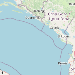
Use this park location map to pinpoint Biogradska Gora in Montenegro, understand its exact geographic position, and read its mapped placement within the surrounding landscape more clearly.

Pigeon | © OpenStreetMap contributors

Location context for Biogradska Gora

Kolašin Municipality
Recorded earthquake history

Review the Historical Earthquake Catalogue for Biogradska Gora

Examine documented seismic events associated with the geography of Biogradska Gora. This collection provides an accessible overview of historical earthquake records and their proximity to the park, helping users understand regional seismic history through structured data and mapped epicentre locations.

Biogradska Gora Earthquake History

Catalogued events

64 events

Strongest magnitude

Magnitude 5.1

Most recent event

Feb 11, 2018

This history includes earthquakes recorded inside the park or within 50 km of its borders

Visual reference for old growth temperate forests, glacial lakes, and Balkan mountain terrain.

Biogradska Gora Landscape and Scenery Photography

Visual documentation captures the old growth temperate beech canopy and high altitude glacial lakes defining Biogradska Gora. Photographic records reveal the dramatic transition from dense primeval forest reserves to sweeping Bjelasica mountain ridges.

A wooden dock on a quiet lake at Biogradska Gora with several small orange rowboats moored to it, set against a backdrop of lush green forested mountains under a cloudy sky.

Sunlight rays piercing through a dense temperate forest canopy, illuminating tall tree trunks and green foliage in Biogradska Gora.

A close up view of an interactive educational sign in a park, showing a picture of a common toad and text in both Serbian and English, with a wooden flap being lifted by a hand.

A wooden boardwalk path leads through a lush, deciduous forest with thin tree trunks and green undergrowth. A green and white trail marker is visible on a tree in the foreground.

Park atlas

Compare nearby national parks and connected protected landscapes across the regional terrain

Parks Near Biogradska Gora and Protected Areas in the Surrounding Mountain Region

Browse other national parks and protected areas located near Biogradska Gora to compare regional mountain topography and forest ecosystems. Continuing the geographical comparison reveals broader patterns across surrounding Balkan protected landscapes.
Watercolor painting showing a mountain landscape with green forests, valleys, and distant hills
National parkMontenegro
Mapped location lies within the park boundary#1 closest

Northwest

Biogradska Gora National Park: Ancient Beech Forest and Protected Landscape Exploration

Discover Montenegro's oldest national park with mapped terrain and regional geography.

Biogradska Gora National Park represents a critical protected area in Montenegro, celebrated for its exceptionally well-preserved ancient beech forest. This national park features a heterogeneous terrain of rolling hills and river valleys that create a unique natural setting. The dense, old-growth canopy offers an immersive experience of a primeval forest ecosystem, providing significant value for understanding Balkan nature and protected forest dynamics. Explore the mapped boundaries and discover the distinct landscape character that defines this remarkable natural reserve.

IUCN
II
Watercolor painting showing a mountainous landscape with a lake, green hills, and pink flowers
National parkAlbania
20 km away#2 closest

South

Alps of Albania National Park: Explore Albania's Largest Protected Alpine Wilderness

Dramatic karst, glacial valleys, and high-altitude ecosystems await.

The Alps of Albania National Park offers an expansive view into one of the Balkans' most significant mountain protected areas. This national park encompasses a spectacular landscape characterized by towering limestone peaks, deep glacial valleys carved over millennia, and intricate karst formations like Grunas Canyon. Its pristine wilderness protects diverse high-altitude ecosystems and unique geological features, serving as a key destination for understanding regional geography and protected landscapes.

Area
828.447 km²
Established
2022
IUCN
II
Relief
Mountain
Watercolor painting of green mountains, forests, and fields under a light sky
National parkKosovo
28 km away#3 closest

Southeast

Bjeshkët e Nemuna National Park: Kosovo's Largest Alpine Protected Landscape

Explore dramatic mountains, glacial lakes, and diverse ecosystems.

Delve into the protected geography of Bjeshkët e Nemuna National Park, Kosovo's expansive national park located in the Accursed Mountains. This atlas entry details its significant alpine terrain, from dense forests to high-altitude meadows, and highlights the presence of glacial lakes like Liqenat. Understand its role as a vital conservation corridor and a key component of the Balkan's natural heritage.

Area
630.28 km²
Established
2012
IUCN
II
Relief
Mountain
A watercolor illustration of a soft mountain range landscape with pine trees in the foreground against a white background.
Protected areaAlbania
About 45 km away#4 closest

South

Accursed Mountains: Geographic Analysis of Albania High Alpine Protected Terrain

Rugged karstic relief and glacial mountain landscapes.

Discover the Accursed Mountains, a formidable high-mountain range in northern Albania known for its sheer limestone cliffs and profound glacial sculpting. This protected area provides a critical habitat for relict flora and fauna while maintaining one of the most intense relief profiles in the Balkans. Examine the mapped canyons, alpine cirques, and jagged ridges that shape this landmark range.

Relief
Mountain
Climate
Alpine
Access
Moderate access
Scope
Terrestrial
A soft watercolor illustration of a mountain range with foreground meadows and trees, rendered in light green, pink, and muted purple tones against a white background.
National parkŽabljak
About 50 km away#5 closest

Northwest

Durmitor National Park: Exploring the Dinaric Alps and Tara River Canyon Landscapes

High-altitude mountain geography and glacial plateau systems

Durmitor National Park preserves a unique concentration of limestone peaks, deep river gorges, and eighteen glacial lakes within the northern highlands of Montenegro. This protected area showcases the interplay between the massive Tara River Canyon and the high-elevation Jezerska površ plateau, offering a comprehensive look at the diverse mountain terrain that defines this Dinaric Alpine wilderness.

Area
390 km²
Established
1952
IUCN
II
Relief
Mountain
Watercolor illustration showing mountains, a winding river, and forested areas
National parkMontenegro
About 50 km away#6 closest

Northwest

Durmitor National Park: Geography and Protected Landscape Atlas of Northern Montenegro

Alpine mountain terrain, deep river canyons, and glacial lake ecosystems.

Delve into the geography of Durmitor National Park, a rugged sanctuary in Montenegro that protects spectacular limestone peaks and the dramatic Tara River canyon. This protected area highlights the geological complexity of the Dinaric Alps through its U-shaped valleys, karst features, and diverse alpine meadows that define this significant regional wilderness.

IUCN
II
Relief
Mountain
Climate
Alpine
Scope
Terrestrial
A soft watercolor illustration of a mountain landscape with coniferous trees, rolling hills, and hazy pink mountains in the distance, set against a plain white background.
Nature reserveKukës County
About 57 km away#7 closest

Southeast

Gashi Valley Nature Reserve: A Geographic Profile of Alpine Albania

Glacial terrain and protected primeval forests in Kukës County

Gashi Valley represents a vital nature reserve and protected alpine landscape in the Albanian Alps. Characterized by its glacial history, the area contains rugged ridges, morainic lakes, and primeval beech forests that serve as a crucial benchmark for European broadleaf ecosystems. This site offers deep insight into the complex geology and ecological significance of the northeastern mountain regions in Albania.

Area
30 km²
IUCN
Ia
Relief
Mountain
Climate
Alpine
A watercolor painting showing a soft, panoramic landscape of low hills, green fields, and water, with a light and ethereal style.
Protected areaMontenegro
About 66 km away#8 closest

Southwest

Cijevna Protected Area: Mapping the River Canyon and Balkan Highlands Geography

An alpine river system spanning the Montenegro and Albania border

The Cijevna represents a striking natural corridor carved into the Prokletije mountains. This protected landscape is defined by its deep V-shaped valleys, high-altitude gorges, and seasonal discharge patterns that sustain important freshwater biodiversity across the Balkan highlands.

Common questions about visiting, size, designation, and location context for Biogradska Gora

Biogradska Gora FAQs for park facts, access, geography, and protected area context

Find quick answers about Biogradska Gora, including protected-area facts, park geography, trail and visitor context, and how the park fits into its surrounding country and regional landscape.
MoriAtlas Explorer

Continue Your Protected Areas Search Across the Global Atlas

Deepen your exploration by continuing the structured search for national parks and protected areas worldwide. Utilize the comprehensive filtering capabilities to compare different conservation landscapes and refine your understanding of global park geography. Discover more about the distribution and characteristics of protected natural areas.

Global natural geography