

Mori Atlas logo
Nature reserveBoorganna Nature Reserve

Mapping the ecological remnants and volcanic plateau terrain of this historic reserve

Boorganna Nature Reserve: A Detailed Geographic Atlas of Protected Rainforest Landscapes

Boorganna Nature Reserve stands as a crucial fragment of original subtropical rainforest on the Comboyne Plateau in New South Wales. This protected landscape contains a dense mosaic of forest types, ranging from eucalyptus woodlands to gully rainforest, all shaped by the unique basalt geology of the Great Dividing Range hinterland. The mapped boundaries preserve an ecologically significant refuge that illustrates the historical transition of eastern Australian vegetation across steep terrain and deep river gullies.

nature reservesubtropical rainforestwarm temperate rainforestgully rainforesteucalyptus forestrainforest birds

Boorganna Nature Reserve

Nature reserve

Park overview

Structured park overview, official facts, and landscape profile for Boorganna Nature Reserve

Boorganna Nature Reserve park facts, protected area profile, and essential visitor context

Review the core facts for Boorganna Nature Reserve, including designation, size, terrain, visitor scale, habitats, and operating context in one park-focused overview.

About Boorganna Nature Reserve

Boorganna Nature Reserve is a compact but ecologically dense protected area on the Comboyne Plateau in New South Wales, situated northwest of Taree and within easy reach of Wingham, Wauchope and Port Macquarie. Although small in area, it protects a remarkable variety of forest types and rainforest character that has largely disappeared from the surrounding plateau. Its position between the coast and the Great Dividing Range, combined with elevations between roughly 360 and 732 metres, produces a cooler, wetter microclimate than the nearby Manning and Hastings coastlines.

The plateau on which the reserve sits was once covered by extensive subtropical rainforest, but almost all of that forest was cleared between 1900 and 1925, with Australian red cedar logged from the area in the nineteenth century. Boorganna survives as an important remnant of that vanished landscape, and it gained formal protection early in the history of New South Wales conservation: it was gazetted in 1904, making it the second oldest nature reserve in the state.

Today the reserve is managed by the NSW National Parks and Wildlife Service and supports picnic areas, walking trails, an information board and a lookout over Rawson Falls. Visitors approach the forest through a transition zone of small birds at the forest edge, then move into tall subtropical jungle studded with rosewood, yellow carabeen and small leaf fig. The reserve holds additional interest as a place that was once proposed for inclusion in the Gondwana Rainforests of Australia World Heritage area but was ultimately rejected because of its isolation from the other rainforest tracts in that group.

Quick facts and research context for Boorganna Nature Reserve

Boorganna Nature Reserve lies on the Comboyne Plateau in the Mid North Coast hinterland of New South Wales, north of Taree and west of Port Macquarie. It covers a small footprint of around 396 hectares and sits at elevations ranging from about 360 to 732 metres, giving it a cooler climate than the nearby coast while still supporting subtropical rainforest.

The reserve was gazetted in 1904 and is the second oldest nature reserve in New South Wales. It is managed by the NSW National Parks and Wildlife Service and was once proposed for inclusion in the UNESCO-listed Gondwana Rainforests, though it was ultimately excluded because it was geographically isolated from the main rainforest complexes. The reserve is reached from the Oxley Highway and the small town of Comboyne.

Protection and recognition

Documented terrestrial protection scope, designation history, and recognition records

Boorganna Nature Reserve Protection Status and Terrestrial Conservation Data

Boorganna Nature Reserve holds a recorded terrestrial protection scope within its designated conservation framework. Documented protection status details, management parameters, and international recognition metrics organize cleanly for comprehensive reserve analysis.

Protection details

Protection scope
Terrestrial
Transboundary protection
No
Park context

Deeper park guide and search-rich context for Boorganna Nature Reserve

Boorganna Nature Reserve history, landscape, wildlife, and travel context

Explore Boorganna Nature Reserve through its history, landscape character, ecosystems, wildlife, conservation priorities, cultural context, and seasonal travel timing in a structured park guide built for atlas discovery and search intent.

Why Boorganna Nature Reserve stands out

The reserve's identity centers on its remnant subtropical rainforest sitting at the southern end of many rainforest species' natural range, including sour cherry, purple cherry, white apple, turnipwood and red carabeen. It is also notable for the large rosewood, yellow carabeen and small leaf fig trees that dominate the canopy. Equally distinctive is the layered mosaic of rainforest types within a small area: subtropical jungle on deep red basalt soils, warm temperate rainforest on poorer soils, steep gully rainforest, dry rainforest on exposed sites, and eucalyptus forest shaped by fire. The reserve's long history, as one of the earliest formal rainforest protections in New South Wales, gives it additional significance in the story of Australian conservation.
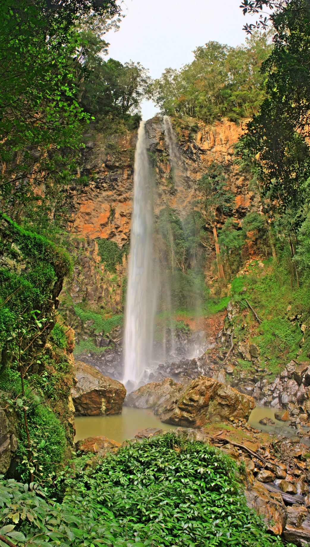
A tall, narrow waterfall cascades down a textured, orange-brown cliff face into a rocky pool, surrounded by dense green temperate rainforest.
Rawson Falls flowing over the rocky escarpment within Boorganna Nature Reserve.

Boorganna Nature Reserve history and protected-area timeline

The Boorganna area was part of an extensive rainforest landscape that covered much of the Comboyne Plateau prior to European settlement. Australian red cedar was logged from the region throughout the nineteenth century, and between 1900 and 1925 most of the plateau's rainforest was cleared for agriculture, leaving only small fragments.

Recognizing the value of what remained, the New South Wales government gazetted the Boorganna Nature Reserve on 12 March 1904, placing the surviving forest under formal protection less than a decade after the worst of the clearing had ended. It remains the second oldest nature reserve in the state. At one point the area was proposed for inclusion in the Gondwana Rainforests World Heritage group, but it was rejected because of its geographic isolation from the other rainforest components of that nomination.

The reserve is now managed by the NSW National Parks and Wildlife Service. The historical knowledge, uses and presence of Indigenous Australians in this part of the Comboyne Plateau are noted in the reserve's documentation as not well known in the present day, reflecting gaps in the historical record rather than an absence of connection to the land.

Boorganna Nature Reserve landscape and geographic character

The reserve occupies part of the Comboyne Plateau in the eastern hinterland of New South Wales, northwest of Taree and to the south of the Oxley Highway. Its terrain rises from about 360 metres to roughly 732 metres above sea level, producing a cooler, mist-prone environment compared with the coast just to the east. From the picnic area near the forest, visitors can take in elevated views over the surrounding wooded landscape.

Geologically the plateau is built on Miocene basalt that weathers into a deep red loam. Beneath the basalt lie less fertile sedimentary rocks, including pebbly mudstone, conglomerate, siltstone and shale, with occasional serpentinite outcrops. Where the reserve adjoins the Great Dividing Range in the west, erosion has carved deep gullies, isolated hills and sharp-edged rocky ridges, with exposed cliffs, rocks and shallow soils.

Water plays a central role in shaping the terrain: Rawson Falls is one of the landscape's defining features, with walking trails leading to a lookout above the falls and views of the water plunging into the dense rainforest below. Steep-sided narrow gullies south of Mumford's Creek create sheltered pockets where gully rainforest has persisted.
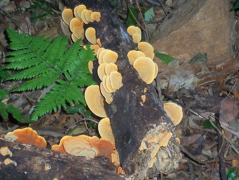
Clusters of rounded, tan-colored shelf fungi attached to a fallen dark log on the rainforest floor, with a bright green fern frond visible to the left.
A cluster of bracket fungi growing on a decaying log in the Boorganna Nature Reserve.

Boorganna Nature Reserve ecosystems, habitats, and plant life

Boorganna protects an unusually fine example of layered rainforest within a small area. The dominant type is subtropical rainforest, a dark, closed forest of very tall trees with broad trunks, including large rosewood, yellow carabeen and small leaf fig, as well as Moreton Bay fig, black booyong, giant stinging tree, pigeonberry ash, brush box and silver quandong. Smaller plants of note along the forest floor include the walking stick palm and Macleay laurel.

On poorer soils below the most fertile basalt, warm temperate rainforest dominates, with coachwood, watergum, sassafras and lilly pilly. In steep gullies south of Mumford's Creek, a gully rainforest mixes subtropical and warm temperate species such as the whalebone tree, walking stick palms and the Bangalow palm. On the shallowest, most exposed soils, dry rainforest features grey myrtle and shatterwood, while the more fire-prone zones carry eucalyptus forest.

The reserve's wetter eucalyptus areas include Sydney blue gum, brush box, tallowwood and New England blackbutt, with some especially tall tallowwood individuals; drier eucalyptus patches instead support black sheoak. The reserve sits near the southern natural range limit for several rainforest species such as sour cherry, purple cherry, white apple, turnipwood and red carabeen. Antarctic beech, once present here, is now considered extinct in the reserve, though some of its associated species persist.
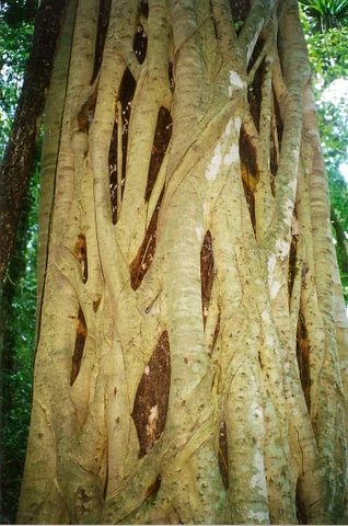
Close up view of the textured, interlaced trunk of a large strangler fig tree in a forest setting.
The distinctive strangler fig, Ficus obliqua, in the rainforest of Boorganna Nature Reserve.

Boorganna Nature Reserve wildlife and species highlights

Although many of Boorganna's animals are nocturnal and rarely seen in the dense rainforest, the reserve supports a rich and varied fauna. Mammals recorded here include several bat species, wallabies, possums, gliding possums, the spotted quoll, platypus, bandicoots, pademelons, bush rats and antechinus, alongside snakes and lizards such as the southern angle-headed dragon.

Birdlife is particularly diverse. Roughly a hundred species have been recorded in the reserve. Rainforest pigeons are a noticeable presence, with the rose-crowned fruit dove and wompoo fruit dove among the characteristic species. Less commonly seen species include the noisy pitta, green catbird and Australasian figbird. Small birds frequently appear around the forest edge near the picnic area.

The invertebrate fauna is not fully documented but is known to be abundant, including insects, arachnids, molluscs and worms across the rainforest floor. Leeches are a familiar sight for bushwalkers after rain, while other characteristic invertebrates include the red triangle slug, blue planarian and tree-dwelling snails. After autumn rain, the reserve is also notable for colourful fungi such as rainbow bracket fungi on fallen logs.
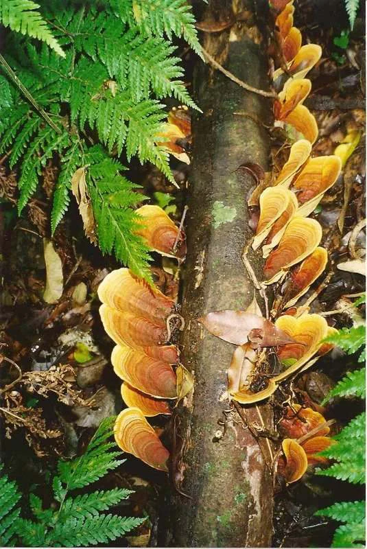
A close-up vertical shot of orange-brown bracket fungi growing in a row along a decaying log, surrounded by lush green ferns on the forest floor.
Bracket fungi growing on a fallen log in the rainforest understory of Boorganna Nature Reserve.

Boorganna Nature Reserve conservation status and protection priorities

Boorganna's conservation significance lies primarily in its role as a surviving fragment of the once-extensive subtropical rainforest of the Comboyne Plateau. Almost all of that surrounding forest was cleared between 1900 and 1925, so the reserve now stands as a key refuge for rainforest plants and animals that have been largely lost from the regional landscape. Its early gazetting in 1904, just as the worst clearing was ending, gave this particular patch formal protection decades before rainforest conservation became mainstream in Australia.

The reserve's high level of botanical diversity, including several species near their southern natural range limit, and the presence of relics such as the former Antarctic beech community, give it additional scientific and conservation value. Its proposed inclusion in the Gondwana Rainforests World Heritage area reflects recognition of the reserve's broader significance, even though it was ultimately excluded from the listing because of its geographic isolation.

Management by the NSW National Parks and Wildlife Service continues to focus on maintaining the integrity of the rainforest and eucalyptus communities. The reserve's mosaic of vegetation types, shaped by elevation, soil, fire history and topography, makes it a useful natural laboratory for understanding how rainforest remnants persist in fragmented rural landscapes.

Boorganna Nature Reserve cultural meaning and human context

The cultural history of the Boorganna area is poorly recorded in contemporary documentation. The Comboyne Plateau and surrounding hinterland were part of the broader landscape used and known by Indigenous Australians, but the exploration, knowledge, specific uses and deeper history of this area by Aboriginal people are not well documented in the present day public record.

In the more recent colonial period, the plateau was the focus of selective logging, particularly for Australian red cedar in the nineteenth century, before the broader rainforest clearance between 1900 and 1925 transformed the region's economy and ecology. The 1904 reserve itself can be read as one of the earliest formal acknowledgments, within the New South Wales conservation system, that this landscape held values worth protecting beyond its timber resource.
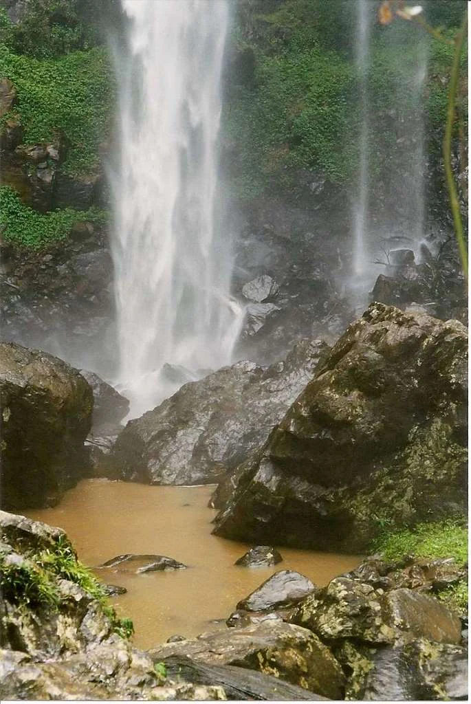
A vertical view of Rawsons Falls plunging into a muddy, rock-lined pool surrounded by lush green rainforest vegetation.
The base of Rawsons Falls in Boorganna Nature Reserve.

Top sights and standout views in Boorganna Nature Reserve

Boorganna packs an unusual concentration of forest types and wildlife into a small reserve, from subtropical jungle with massive rosewood, yellow carabeen and small leaf fig to warm temperate, gully, dry and eucalyptus forests. The Rawson Falls lookout and the network of walking trails give visitors a structured way to experience this layered landscape.

The reserve's value is amplified by what surrounds it: a once-vast plateau rainforest that was almost entirely cleared, leaving Boorganna as a key surviving fragment. Its 1904 status as the second oldest nature reserve in New South Wales, its near-southern-range rainforest species, and its rejected but historically meaningful Gondwana Rainforests proposal all add depth to its identity.
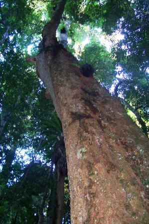
A low angle perspective looking up the trunk of a large, mature tree surrounded by dense rainforest foliage.
A tall native Rosewood tree reaching into the rainforest canopy in the Comboyne region.

Best time to visit Boorganna Nature Reserve

Because the reserve sits on an elevated plateau between roughly 360 and 732 metres, its cooler microclimate tends to feel milder than the nearby coast. The annual rainfall of around 1,930 millimetres is spread across the year, so wet conditions are possible at any season, with rain often a feature of visits.

Autumn is characterized in the source material as a particularly rewarding time for fungi, when colourful and sometimes spectacular species, including rainbow bracket fungi on fallen logs, become noticeable after wet weather. Cooler temperatures also make walking the rainforest trails to Rawson Falls comfortable, while the dense forest shows the reserve at its most atmospheric. Spring and summer offer lush growth and active birdlife, though wetter conditions and leeches along the trails are more likely after rain.

Monthly climate preview

Long term representative measurements tracking temperature and precipitation rhythm by month

Boorganna Nature Reserve Climate Normals and Annual Temperature Patterns

Boorganna Nature Reserve records measured temperature and precipitation rhythms across the year based on historical point climatology from 1991 to 2020. Examining the complete twelve month profile reveals detailed monthly averages that clarify long term regional climate variations.
Annual mean17 °C
11 °C23 °C
Jan23°
Feb22°
Mar20°
Apr18°
May15°
Jun12°
Jul11°
Aug13°
Sep16°
Oct18°
Nov20°
Dec21°
Warmest month
January

22.8 °C

Coolest month
July

11.5 °C

Wettest month
February

6 mm/day

Driest month
August

1.6 mm/day

Park location guide

Geography guide, regional context, and park location map for Boorganna Nature Reserve

Boorganna Nature Reserve park geography, regions, and map view in Australia

Understand where Boorganna Nature Reserve sits in Australia through a broader geographic reading of the surrounding landscape, nearby location context, and its mapped position within the national park landscape.

How Boorganna Nature Reserve fits into Australia

Australia is a constitutional monarchy and federal parliamentary democracy comprising six states and ten territories. With a population of nearly 28 million, it is one of the world's most urbanised countries, with most people concentrated on the eastern seaboard. The country has a high Human Development Index and is known for its cultural diversity, ancient Aboriginal heritage, and unique wildlife.

Wider geography shaping Boorganna Nature Reserve in Australia

Australia occupies the entire Australian continent, the island of Tasmania, and numerous smaller islands. It is the world's flattest and driest inhabited continent, featuring vast deserts in the interior (the Outback), tropical rainforests along the eastern coast, and a coastline bordering the Indian and Pacific Oceans.

Map view of Boorganna Nature Reserve

Use this park location map to pinpoint Boorganna Nature Reserve in Australia, understand its exact geographic position, and read its mapped placement within the surrounding landscape more clearly.

Pigeon | © OpenStreetMap contributors

Location context for Boorganna Nature Reserve

New South Wales

Visual reference of plateau rainforest habitats and protected terrain

Boorganna Nature Reserve Photos and Landscape Scenery

Visual records capture the dense subtropical canopy, deep gullies, and waterfall environments defining Boorganna Nature Reserve. Detailed photography reveals the complex forest mosaic and protected plateau terrain preserved across the region.

A tall, narrow waterfall cascades down a textured, orange-brown cliff face into a rocky pool, surrounded by dense green temperate rainforest.

A pale, slender Southern Angle-headed Dragon lizard clinging vertically to a light-colored tree trunk in a rainforest setting, surrounded by green serrated leaves.

Clusters of rounded, tan-colored shelf fungi attached to a fallen dark log on the rainforest floor, with a bright green fern frond visible to the left.

Close up view of the textured, interlaced trunk of a large strangler fig tree in a forest setting.

A close-up vertical shot of orange-brown bracket fungi growing in a row along a decaying log, surrounded by lush green ferns on the forest floor.

A close-up view of the base and trunk of a large rainforest tree with light colored, smooth bark and buttress roots in a shaded forest environment.

A vertical view of Rawsons Falls plunging into a muddy, rock-lined pool surrounded by lush green rainforest vegetation.

A low angle perspective looking up the trunk of a large, mature tree surrounded by dense rainforest foliage.

Close-up photograph showing the textured bark of a Ficus obliqua tree, marked by strong shadows and light patches.

A grassy picnic area with metal picnic tables in Boorganna Nature Reserve, surrounded by dense subtropical rainforest trees.

A tall, narrow waterfall plunges down a steep, rocky, tree-covered cliff face.

Park atlas

Compare nearby national parks and regional conservation areas across the plateau terrain.

Other Parks Near Boorganna Nature Reserve and Surrounding Protected Landscapes

Browsing other parks near Boorganna Nature Reserve reveals connected regional geography and surrounding rainforest fragments. Comparing these protected landscapes provides broader context for eastern Australian plateau ecosystems.
A soft watercolor illustration of a rolling landscape with green trees, a dirt path, and a light-filled background.
Nature reserveNew South Wales
About 2.1 km away#1 closest

South

Killabakh Nature Reserve: Protected Forest Boundaries and Great Dividing Range Geography

Mapped conservation estate in coastal New South Wales

Killabakh Nature Reserve serves as a significant protected land entity within the New South Wales forest network. This site features rugged escarpment terrain dominated by wet sclerophyll eucalyptus and remnant rainforest. Its preservation contributes to long-term ecological connectivity along the Great Eastern Escarpment, showcasing a distinctive botanical profile rooted in the local landscape and regional environmental history.

Area
26.44 km²
Established
1999
IUCN
Ia
Relief
Mountain
National parkNew South Wales
About 11 km away#2 closest

Northwest

Biriwal Bulga National Park: Protected Landscape and Geographic Context within New South Wales

Explore mapped boundaries and the national park's regional setting.

Biriwal Bulga National Park represents a significant protected area within New South Wales, Australia, offering crucial insights into the region's natural landscape geography. This dedicated page details the park's specific identity as a national park, focusing on its mapped geographic boundaries and its contribution to the broader atlas of protected lands. It is designed for users who require structured information about individual protected areas and their precise location and landscape context.

Area
65.28 km²
Established
1999
IUCN
II
Relief
Lowland
National parkMid North Coast
About 11 km away#3 closest

West

Tapin Tops National Park: Protected Landscape in Mid North Coast, Australia

Mapped geographic context and natural terrain discovery.

Tapin Tops National Park is a designated national park offering rich opportunities for geographic and landscape exploration. This detail page provides a structured look at its protected area status and its location within the Mid North Coast region of Australia. Delve into the mapped boundaries and understand the park's specific natural terrain for comprehensive atlas-based discovery.

Area
110 km²
Established
1999
IUCN
II
Relief
Mountain
National parkNew South Wales
About 12 km away#4 closest

Southeast

Coorabakh National Park: A Protected Volcanic Landscape in New South Wales

Discover unique terrain, mapped protected boundaries, and regional geography.

Coorabakh National Park in New South Wales, Australia, is characterized by its striking volcanic trio: Big Nellie, Flat Nellie, and Little Nellie. These peaks dominate the rugged escarpment terrain, offering a unique geographic vista. The park protects a rich mosaic of tall eucalypt forests and sheltered subtropical rainforest gullies, highlighting its ecological diversity. For those interested in atlas-style exploration, Coorabakh National Park provides a clear example of a protected landscape with significant geological and ecological features within the broader regional context of New South Wales.

Area
18 km²
Established
1999
IUCN
II
Relief
Highland
National parkNew South Wales
About 20 km away#5 closest

Northeast

Bago Bluff National Park: New South Wales National Park with Panoramic Views

Explore its mapped geography and protected forest landscapes.

Bago Bluff National Park in New South Wales presents a remarkable protected landscape characterized by its prominent bluff formation, offering breathtaking panoramic views over the Hastings Valley. This national park preserves extensive wet sclerophyll forests and eucalypt woodlands, contributing to a rich mosaic of natural habitats and supporting a vibrant bird population. The park's geography is deeply tied to its geological history, with local quarries revealing significant fossil specimens. As a key protected area, it provides valuable context for understanding the regional landscape and mapped natural terrain of eastern Australia.

Area
40.23 km²
Established
1999
IUCN
II
Relief
Upland
National parkNew South Wales
About 25 km away#6 closest

Northwest

Cottan-Bimbang National Park: A Protected Landscape in New South Wales

Explore its mapped boundaries and regional geographic context.

Delve into the protected landscape of Cottan-Bimbang National Park, a key national park situated in New South Wales, Australia. This page provides detailed insight into its geographic setting and mapped park boundaries, offering a clear understanding of its regional importance. Discover the distinct natural landscape characteristics that define Cottan-Bimbang National Park within the broader Australian atlas.

Area
269 km²
Established
1999
IUCN
II
Climate
Temperate
National parkNew South Wales
About 25 km away#7 closest

East

Middle Brother National Park: New South Wales Protected Area and Geographic Exploration

Mapped boundaries and regional landscape context for this national park.

Middle Brother National Park represents a distinct protected landscape within the state of New South Wales, Australia. This entry offers detailed geographic context, focusing on the park's mapped boundaries and its significance as a national park. Users can explore its place within the regional geography of New South Wales, gaining a structured understanding of this protected area through an atlas-focused perspective.

Area
18.3 km²
Established
1999
IUCN
II
Relief
Mountain
Nature reserveNew South Wales
About 26 km away#8 closest

South

Wingham Brush Nature Reserve: Protected Rainforest and Manning River Floodplain Geography

An essential ecological sanctuary in coastal New South Wales.

Wingham Brush Nature Reserve represents a critical protected landscape featuring subtropical rainforests on the Manning River floodplain. This unique site, known for its massive Moreton Bay figs and successful regeneration methods, provides a sanctuary for avian and reptilian life amidst the broader coastal plains of eastern Australia.

Area
0.08 km²
Established
2000
IUCN
IV
Relief
Lowland

Common questions about visiting, size, designation, and location context for Boorganna Nature Reserve

Boorganna Nature Reserve FAQs for park facts, access, geography, and protected area context

Find quick answers about Boorganna Nature Reserve, including protected-area facts, park geography, trail and visitor context, and how the park fits into its surrounding country and regional landscape.
MoriAtlas Explorer

Continue Your Protected Areas Search Across the Global Atlas

Deepen your exploration by continuing the structured search for national parks and protected areas worldwide. Utilize the comprehensive filtering capabilities to compare different conservation landscapes and refine your understanding of global park geography. Discover more about the distribution and characteristics of protected natural areas.

Global natural geography