Mori Atlas logo
National parkBørgefjell National Park

Discover dramatic granite peaks, remote marshes, and arctic fox habitat within Nordland's geographic context.

Børgefjell National Park: Norway's Vast Undeveloped Wilderness Landscape

(Børgefjell nasjonalpark)

Børgefjell National Park represents one of Norway's most extensive and undeveloped protected wilderness areas, spanning a significant portion of the Nordland region's dramatic mountain terrain. This atlas-focused exploration reveals a landscape dominated by rugged granite peaks, fertile mountain slopes, vast marshlands, and numerous lakes and rivers, offering a unique glimpse into a preserved natural environment. Understanding Børgefjell National Park's geographic boundaries and ecological significance provides essential context for appreciating its role as a critical habitat and a testament to Norway's commitment to conservation.

wildernessmountainsarctic foxremotegranite peakswetlands

Børgefjell National Park

National park

Park overview

Structured park overview, official facts, and landscape profile for Børgefjell National Park

Børgefjell National Park park facts, protected area profile, and essential visitor context
Review the core facts for Børgefjell National Park, including designation, size, terrain, visitor scale, habitats, and operating context in one park-focused overview.

About Børgefjell National Park

Børgefjell National Park represents one of Norway's most extensive and least-visited protected wilderness areas, covering 1,447 square kilometers of mountainous terrain along the country's border with Sweden. The park spans four municipalities: Hattfjelldal, Grane, Namsskogan, and Røyrvik, encompassing a landscape of remarkable topographic diversity. The western portions feature the park's most dramatic terrain, where dark Børgefjell granite dominates and gives the landscape its characteristic desolate appearance. Here, the highest peaks rise sharply above the tree line, with Kvigtinden reaching 1,699 meters and Jetnamsklumpen standing at 1,513 meters as the tallest mountain in Trøndelag. The park's name derives from the Old Norse word 'byrgi,' meaning fort or entrenchment, likely referencing historical fortifications used to collect taxes from southern Sami peoples and protect the border from Swedish incursions. The Sami people maintained control of this land until the early twentieth century, and their cultural heritage remains visible through ancient settlements and hunting stations scattered throughout the park and surrounding border areas.

Quick facts and research context for Børgefjell National Park

Børgefjell National Park covers 1,447 km² along the Norway-Sweden border in northern Norway, straddling Trøndelag and Nordland counties. The park was established in 1963 and enlarged three times, most recently in 2003. The highest peak is Kvigtinden at 1,699 meters, while Jetnamsklumpen at 1,513 meters is the tallest mountain in Trøndelag. The landscape features dark Børgefjell granite in the west creating a desolate appearance, contrasted with fertile slopes and marshes. The tree line sits at 500-600 meters, with birch forest dominating below this elevation.

Park context

Deeper park guide and search-rich context for Børgefjell National Park

Børgefjell National Park history, landscape, wildlife, and travel context
Explore Børgefjell National Park through its history, landscape character, ecosystems, wildlife, conservation priorities, cultural context, and seasonal travel timing in a structured park guide built for atlas discovery and search intent.

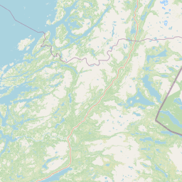
Why Børgefjell National Park stands out

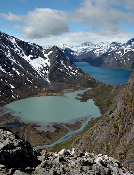
Børgefjell is best known as the primary stronghold for the rare Arctic fox in Norway, though the wolverine is actually the most common large predator in the park. The park's dramatic granite mountain landscape, particularly around Kvigtinden and Jetnamsklumpen, represents some of the most impressive alpine terrain in northern Norway. The extreme remoteness and lack of development distinguish this park from most other Norwegian protected areas, offering a genuine wilderness experience where visitors can spend days hiking without seeing another person.

Børgefjell National Park history and protected-area timeline

The human history of Børgefjell stretches back centuries, with the Sami people maintaining continuous presence in the region for at least 500 years. The Sami controlled the land right up until the beginning of the twentieth century, establishing settlements and hunting stations throughout what is now the national park and the adjacent border areas. These cultural monuments remain visible today as evidence of the deep historical connection between indigenous peoples and this landscape. The first Norwegian farms appeared at the end of the eighteenth century and the beginning of the nineteenth century, driven by land scarcity elsewhere in Norway that pushed settlers northward into this challenging terrain. Norwegian settlement gradually increased from this period onward, though the region's remoteness limited substantial development. Børgefjell was originally established as a national park in 1963, representing Norway's commitment to preserving this wilderness area. The park was subsequently enlarged in 1973 and again in 2003, expanding protection to additional land and consolidating the boundary to its current extent.

Børgefjell National Park landscape and geographic character

The physical landscape of Børgefjell National Park presents a striking contrast between dramatic alpine terrain and more gentle wetland environments. The western mountain regions feature rough, dark granite peaks and grey ridgelines with sparse vegetation, creating an almost stark, desolate atmosphere across the high terrain. Sub-glacial moraines cover extensive portions of the landscape, testament to the glacial processes that shaped this region. In contrast, the eastern and southern areas feature more fertile mountain slopes and extensive marshland systems. The park contains numerous lakes and ponds of varying sizes, along with rushing rivers that drain the high terrain. The Rainesfjellet area exemplifies the park's rugged character, with rough stone screes lacking vegetation covering steep slopes. The highest points concentrate in the west where the Børgefjell granite bedrock predominates, while the terrain becomes progressively lower and more gently contoured toward the east.

Børgefjell National Park ecosystems, habitats, and plant life

Børgefjell supports approximately 300 different plant species within its boundaries, distributed across distinct ecological zones defined by elevation and terrain. The tree line occurs at around 500 to 600 meters above sea level, with birch forest forming the dominant tree cover below this elevation. Spruce and pine trees also occur in suitable locations, particularly in valleys and on more protected slopes. Above the tree line, the landscape transitions to alpine meadows and eventually to bare rock and permanent snow fields on the highest peaks. The marshlands and wetlands that characterize portions of the park represent important ecological zones, supporting distinctive plant communities adapted to waterlogged conditions. The extensive reindeer grazing throughout the park, particularly in the western, eastern, and southern areas used seasonally and the northern areas used year-round, creates a dynamic interaction between traditional land use and natural ecosystems.

Børgefjell National Park wildlife and species highlights

Børgefjell harbors a remarkable assemblage of wildlife, with the Arctic fox representing the park's most famous resident despite being rare throughout its range. The wolverine, though less celebrated, is actually the most common large predator present in terms of numbers. Additional large predators include the Eurasian lynx and brown bear, both of which maintain populations within the park boundaries. Smaller predators are well represented, with red fox, least weasel, European pine marten, and stoat all present. The Eurasian otter occasionally appears near water bodies. The park supports significant bird populations, including willow ptarmigan and rock ptarmigan as characteristic species. Birds of prey are represented by the rough-legged buzzard, which is common throughout the park, along with the occasional snowy owl and golden eagle. All of Børgefjell serves as domestic reindeer grazing habitat, with reindeer from Sweden also utilizing the eastern portions of the park.

Børgefjell National Park conservation status and protection priorities

Børgefjell National Park holds significant conservation value as Norway's primary habitat for the endangered Arctic fox, a species that has suffered severe population declines across its range. The park's extensive size and extreme remoteness provide the large, intact territories that large predators like wolverines, lynx, and bears require. The designation as a Category II protected area under the IUCN framework recognizes the park's role in preserving natural ecosystems while allowing for sustainable use by local Sami reindeer herding communities. The park's undeveloped character, with minimal trail infrastructure and no significant tourist facilities, represents an intentional management approach that prioritizes ecological integrity over visitor access. This wilderness protection model ensures that the natural processes and wild populations that define Børgefjell's ecological character can continue with minimal human disturbance.

Børgefjell National Park cultural meaning and human context

The Sami people maintain a profound historical connection to the Børgefjell landscape, having controlled this territory for centuries and continuing traditional reindeer herding practices within the national park boundaries. The park name itself reflects this heritage, with the Southern Sami name 'Byrkije vaarjelimmiedajve' preserving the indigenous linguistic identity of the region. Sami cultural monuments in the form of settlements and hunting stations remain visible throughout the park and surrounding border areas, representing physical evidence of centuries of traditional land use. Reindeer grazing has occurred in this landscape for at least 500 years, creating a cultural landscape where human activity and ecological processes have co-evolved. This living cultural tradition continues today, with the western, eastern, and southern portions of the park serving as summer grazing areas while the northern sections support year-round reindeer husbandry.

Top sights and standout views in Børgefjell National Park

Børgefjell offers exceptional wilderness solitude in Norway's most extensive undeveloped mountain parks, with visitors able to hike for days without encountering another person. The dramatic granite peaks of Kvigtinden and Jetnamsklumpen provide spectacular alpine scenery and challenging climbing opportunities. The rare Arctic fox remains the park's most iconic species, though sighting requires patience and luck. The extensive marshland systems and network of lakes create diverse habitats supporting over 300 plant species. The park's location along the Norwegian-Swedish border adds historical dimension, with the Old Norse name 'byrgi' referencing fort-like structures once used for border control and tax collection from Sami peoples.

Best time to visit Børgefjell National Park

The summer months from June through August offer the most accessible conditions for hiking and wildlife observation in Børgefjell, with the tree line and higher terrain snow-free and temperatures suitable for extended backcountry travel. The midnight sun of the polar summer provides extended daylight hours for exploration. Autumn in September and October brings the characteristic golden birch forests and potential for aurora borealis viewing in clear skies, though conditions become increasingly unpredictable. Winter visits require substantial expertise and preparation for extreme cold, short daylight hours, and challenging snow conditions, but offer exceptional solitude and the possibility of observing Arctic foxes and wolverines in their winter coats. Spring arrives late to this northern latitude, with May often still featuring significant snow cover at higher elevations.

Park location guide

Geography guide, regional context, and park location map for Børgefjell National Park

Børgefjell National Park park geography, regions, and map view in Norway
Understand where Børgefjell National Park sits in Norway through a broader geographic reading of the surrounding landscape, nearby location context, and its mapped position within the national park landscape.

How Børgefjell National Park fits into Norway

Norway, officially the Kingdom of Norway, is a Nordic country in Northern Europe located on the Scandinavian Peninsula. It encompasses mainland Norway, the Arctic islands of Svalbard and Jan Mayen, and maintains dependencies including Bouvet Island and Antarctic claims. The country has a population of about 5.6 million and is bordered by Sweden, Finland, and Russia. Norway is a unitary parliamentary constitutional monarchy with Oslo as its capital and largest city.

Wider geography shaping Børgefjell National Park in Norway

Norway occupies the western and northern portions of the Scandinavian Peninsula in Northern Europe. The country shares a long eastern border with Sweden, and borders Finland and Russia to the northeast. Norway has an extensive coastline facing the Skagerrak, North Sea, Norwegian Sea, and Barents Sea. The terrain is predominantly mountainous with numerous fjords along the coastline.

Map view of Børgefjell National Park

Use this park location map to pinpoint Børgefjell National Park in Norway, understand its exact geographic position, and read its mapped placement within the surrounding landscape more clearly.

Pigeon | © OpenStreetMap contributors

Location context for Børgefjell National Park

NordlandTrøndelag
Park atlas

Compare remote wilderness, dramatic mountain landscapes, and protected areas across Nordland and adjacent regions.

Explore National Parks and Protected Areas Near Børgefjell National Park in Northern Norway
Browse a curated list of national parks and significant protected areas geographically close to Børgefjell National Park, mapping their alpine terrain and extensive wetlands. This offers valuable geographic context and structured comparison for exploring Norway's rugged northern wilderness and its diverse conservation landscapes.
Watercolor painting of mountains, a river, and trees under a pink and yellow sky
National parkNordland

Lomsdal, Visten National Park: Mapped Protected Landscape and Karst Geology in Nordland

Explore the protected geography of northern Norway's unique terrain.

Delve into the protected world of Lomsdal, Visten National Park, a key national park within Norway's Nordland county. This area is celebrated for its extraordinary geological formations, including significant karst features like caves, subterranean rivers, and natural arches, set against a backdrop of dramatic fjords and rugged mountain landscapes. The park’s diverse ecosystems, from valley woodlands to alpine environments, offer rich context for understanding regional geography and the mapped distribution of protected natural areas in Scandinavia. Discover the unique characteristics that define this significant conservation landscape.

Area
1,102 km²
Established
2009
IUCN
II
National parkTrøndelag

Lierne National Park: A Protected Mountain and Wetland Wilderness in Trøndelag

Explore mapped boundaries, alpine terrain, and Scandinavian wilderness.

Lierne National Park is a prime example of Norway's protected mountain and wetland landscapes, situated in the Trøndelag region. This national park offers a detailed study of terrain shaped by glacial activity, featuring high peaks and expansive peat bogs. Its role in preserving habitats for large carnivores and the Arctic fox adds ecological depth to its geographic profile, providing valuable context for atlas-based discovery of protected areas.

Area
333 km²
Established
2004
IUCN
II
Relief
Mountain
National parkTrøndelag

Blåfjella, Skjækerfjella National Park: Norway's Extensive Protected Wilderness Landscape Atlas

Mapped natural terrain and protected area boundaries in Trøndelag.

Blåfjella, Skjækerfjella National Park stands as a paramount example of Norway's commitment to preserving vast, untouched natural areas. This protected landscape in Trøndelag features expansive mountain plains, glacial valleys, and important wetland habitats, making it a significant area for understanding regional geography and biodiversity. As one of the country's largest national parks, it offers unique insights into the ecological history of spruce migration and serves as a vital sanctuary for large predators. MoriAtlas provides structured map data and geographic context to explore the protected boundaries and diverse terrain of this remarkable wilderness.

Area
1,924 km²
Established
2004
IUCN
II
Relief
Mixed relief
Watercolor illustration showing mountains, a river, and colorful landscape regions
National park

Saltfjellet, Svartisen National Park: Glacial Terrain & Protected Arctic Wilderness

Norway's vast national park with Svartisen glacier and unique flora.

Saltfjellet, Svartisen National Park spans over 2,100 square kilometers of diverse protected wilderness in Northern Norway. Renowned for Svartisen, Scandinavia's second-largest glacier, its landscape transitions from coastal influences to alpine plateaux. The park's calcareous bedrock supports a rich flora, rare in the region, contributing to its distinct geographic identity. Explore the mapped boundaries and natural terrain of this significant protected landscape.

Area
2,192 km²
Established
1989
IUCN
II
Relief
Mixed relief
National parkNorrbotten County

Pieljekaise National Park: Ancient Birch Woodland and Glacial Terrain in Norrbotten

Explore Sweden's protected landscape and mapped geography.

Pieljekaise National Park, a historic protected area in Norrbotten County, showcases one of Scandinavia's most intact boreal birch woodlands. Its landscape is shaped by ancient glacial activity, featuring a U-shaped valley, rolling hills covered in primeval-like birch forests, and distinctive twin peaks. Positioned along the renowned Kungsleden trail, this national park serves as a vital point for understanding the mapped geography and protected natural heritage of Sweden's Lapland region.

Area
153.4 km²
Established
1909
IUCN
II
Relief
Upland
National park

Láhko National Park: Northern Norway's Protected Arctic Landscape and Geographic Atlas Entry

Mapped boundaries and terrain of a key Finnmark national park.

Láhko National Park is a significant protected area within Norway's Finnmark region, representing a vast expanse of sub-Arctic wilderness and characteristic tundra ecosystems. This park serves as a crucial element in the atlas of northern European protected lands, offering insights into the geographic features and ecological integrity of high-latitude environments. Explore Láhko National Park through MoriAtlas to understand its landscape context, mapped terrain, and its role in preserving Nordic wilderness.

Watercolor illustration of a landscape with rolling hills, a river, and trees
National parkNordland

Junkerdal National Park: Protected Arctic-Alpine Landscape in Nordland, Norway

Explore mapped boundaries and unique geographic context.

Delve into Junkerdal National Park, a significant protected area within Nordland county, Norway. This national park is celebrated for its rich arctic-alpine flora, including rare plant species that thrive at their southernmost European range. The varied landscape, shaped by glacial activity, features dramatic mountain valleys and alpine plateaus, offering a distinct geographic profile. Understand its protected status and mapped terrain, providing a critical point of discovery for regional landscape context.

Area
682 km²
Established
2004
IUCN
II
Relief
Mountain
National parkVästerbotten County

Björnlandet National Park: Ancient Pine Forest & Dramatic Protected Landscape in Västerbotten County

Explore mapped boreal terrain and protected area boundaries.

Björnlandet National Park preserves an exceptional example of Sweden's ancient boreal forest, with pines exceeding 450 years in age. The protected landscape is dramatically shaped by steep ravines, cliff faces, and extensive boulder fields, showcasing the raw power of natural processes and fire history. This national park offers a unique opportunity for atlas-style exploration of its mapped terrain and geographic context within Västerbotten County.

Area
11 km²
Established
1991
IUCN
II
Relief
Mixed relief

Common questions about visiting, size, designation, and location context for Børgefjell National Park

Børgefjell National Park FAQs for park facts, access, geography, and protected area context
Find quick answers about Børgefjell National Park, including protected-area facts, park geography, trail and visitor context, and how the park fits into its surrounding country and regional landscape.
MoriAtlas Explorer

Continue Your Protected Areas Search Across the Global Atlas

Deepen your exploration by continuing the structured search for national parks and protected areas worldwide. Utilize the comprehensive filtering capabilities to compare different conservation landscapes and refine your understanding of global park geography. Discover more about the distribution and characteristics of protected natural areas.

Global natural geography