Mori Atlas logo
National parkBouba Ndjida National Park

Discover the mapped geography and protected area context of this vital conservation landscape.

Bouba Ndjida National Park: Protected Savanna and Woodland Landscape in Northern Cameroon

Bouba Ndjida National Park represents a key protected landscape in northern Cameroon, established as one of the nation's earliest conservation areas. Its diverse savanna, woodland, and gallery forest habitats provide essential refuge for significant large mammal populations, including elephants and giraffes. This park sits at a fascinating ecological transition zone, offering a unique geographic context for understanding regional biodiversity and conservation within the broader atlas of protected lands.

savannalarge mammalselephantsnorthern Cameroonprotected savannawildlife viewing

Bouba Ndjida National Park

National park

Park overview

Structured park overview, official facts, and landscape profile for Bouba Njida National Park

Bouba Njida National Park park facts, protected area profile, and essential visitor context

Review the core facts for Bouba Njida National Park, including designation, size, terrain, visitor scale, habitats, and operating context in one park-focused overview.

About Bouba Njida National Park

Bouba Njida National Park occupies a significant position in Cameroon's protected area network as one of the nation's oldest national parks. Located in the northern region of the country, the park protects a landscape characterized by vast savanna plains, woodland areas, and gallery forests along watercourses. The park's location at the transition between different ecological zones gives it particular significance, supporting species from both Sudanian and more humid Guinean environments. The protected area provides crucial habitat for large mammals that have declined across much of the region, making it an important stronghold for wildlife conservation in northern Cameroon.

Quick facts and research context for Bouba Njida National Park

Bouba Njida National Park is located in northern Cameroon, covering approximately 2,200 square kilometers of savanna and woodland habitats. The park was established in 1952 and represents one of Cameroon's oldest protected areas. It is known for populations of elephants, giraffes, and various antelope species. The park sits at the confluence of ecological zones, supporting both Sudanian and Guinean vegetation types.

Park context

Deeper park guide and search-rich context for Bouba Njida National Park

Bouba Njida National Park history, landscape, wildlife, and travel context

Explore Bouba Njida National Park through its history, landscape character, ecosystems, wildlife, conservation priorities, cultural context, and seasonal travel timing in a structured park guide built for atlas discovery and search intent.

Why Bouba Njida National Park stands out

The park is best known for its large mammal populations, particularly elephants, giraffes, buffalo, and various antelope species. Its savanna landscapes provide excellent wildlife viewing opportunities, and the park serves as an important refuge for species adapted to the northern Cameroonian ecological zone.

Bouba Njida National Park history and protected-area timeline

Bouba Njida National Park was established in 1952 during the colonial period, making it one of Cameroon's earliest national parks. Its creation reflected the post-war conservation movement that sought to protect significant natural areas across Africa. The park has faced various management challenges over the decades, including pressures from agricultural expansion and poaching. Conservation efforts have continued despite these challenges, maintaining the park's protected status.

Bouba Njida National Park landscape and geographic character

The park features a predominantly savanna landscape with scattered woodland patches and gallery forests following rivers and streams. The terrain is generally flat to gently rolling, typical of the northern Cameroon plateau. Grassland savanna dominates the higher ground, while more dense woodland occurs in lower areas and near water. The seasonal watercourses that cross the park provide important ecological corridors and support denser vegetation than the surrounding plains.

Bouba Njida National Park ecosystems, habitats, and plant life

Bouba Njida sits at an ecological crossroads, blending elements of the Sudanian zone to the north with characteristics of the Guinea forest-savanna mosaic to the south. This transition creates a diverse habitat mosaic supporting both dry-country and more humid-adapted species. The savanna grasslands provide grazing habitat for large herbivores, while the woodland areas offer cover and food sources for a broader range of species. The gallery forests along rivers serve as critical refuge areas during the dry season.

Bouba Njida National Park wildlife and species highlights

The park supports notable populations of large mammals, including elephants, giraffes, African buffalo, and various antelope species such as roan and kudu. Predators including lions and leopards are also present in the park. The diverse habitats support a range of bird species, with the savanna and woodland areas providing important birding opportunities. The mammal populations represent some of the most significant remaining in northern Cameroon.

Bouba Njida National Park conservation status and protection priorities

Bouba Njida National Park represents an important conservation priority for Cameroon, protecting substantial savanna ecosystems that have been heavily modified across much of the region. The park's long-established protected status has helped maintain wildlife populations that have declined outside protected boundaries. Continued conservation efforts focus on managing human-wildlife conflict, preventing poaching, and maintaining habitat integrity.

Bouba Njida National Park cultural meaning and human context

The park is located in a region inhabited by various local communities whose traditional land use practices have shaped the landscape over generations. The area around the park supports agricultural and pastoral activities that interact with the protected area. Understanding the relationship between local communities and the park's ecosystems is important for effective conservation management.

Top sights and standout views in Bouba Njida National Park

Bouba Njida offers some of the best wildlife viewing opportunities in northern Cameroon, with accessible savanna landscapes that allow visitors to observe elephants, giraffes, buffalo, and other large mammals. The park's position at an ecological crossroads provides habitat diversity that supports a range of species. As one of Cameroon's oldest national parks, it represents a long-standing commitment to conservation in the region.

Best time to visit Bouba Njida National Park

The optimal time to visit Bouba Njida National Park is during the dry season from November to April, when wildlife is more concentrated around remaining water sources and vegetation is less dense, improving visibility. The hot season from March to May offers the best wildlife viewing as animals gather at waterholes. The park is generally accessible during the dry months, while the rainy season from May to October can make some roads difficult to traverse.
Monthly climate preview

Measured monthly average temperature and precipitation rhythm for Bouba Ndjida National Park

Bouba Ndjida National Park Climate Normals and Annual Weather Patterns

Bouba Ndjida National Park exhibits a measured annual cycle of shifting monthly temperatures and precipitation rates based on long term representative coordinate data. Examining the complete twelve month climate profile reveals detailed patterns across daily minimum and maximum readings.
Annual mean28 °C
25 °C32 °C
Jan27°
Feb29°
Mar32°
Apr32°
May30°
Jun28°
Jul26°
Aug25°
Sep26°
Oct27°
Nov27°
Dec26°
Warmest month
April

32.2 °C

Coolest month
August

25 °C

Wettest month
August

8.2 mm/day

Driest month
January

0 mm/day

Park location guide

Geography guide, regional context, and park location map for Bouba Njida National Park

Bouba Njida National Park park geography, regions, and map view in Cameroon

Understand where Bouba Njida National Park sits in Cameroon through a broader geographic reading of the surrounding landscape, nearby location context, and its mapped position within the national park landscape.

How Bouba Njida National Park fits into Cameroon

Cameroon is a Central African country spanning coastal, highland, and forest regions. It has a population of nearly 31 million people who speak 250 native languages alongside English and French as official languages. The country gained independence from France in 1960 and unified with British Southern Cameroons in 1961.

Wider geography shaping Bouba Njida National Park in Cameroon

Cameroon is located in Central Africa, bordering Nigeria and Chad to the west and north, the Central African Republic to the east, and Equatorial Guinea, Gabon, and the Republic of the Congo to the south. The country has a coastline on the Bight of Biafra, part of the Gulf of Guinea. Terrain includes coastal plains, mountainous highlands (including Mount Cameroon), plateaus, and dense rainforest regions.

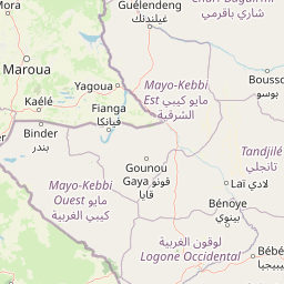
Map view of Bouba Njida National Park

Use this park location map to pinpoint Bouba Njida National Park in Cameroon, understand its exact geographic position, and read its mapped placement within the surrounding landscape more clearly.

Pigeon | © OpenStreetMap contributors
Park atlas

Explore the surrounding savanna and woodland protected landscapes for comparative park geography in the region

Discover More National Parks and Protected Areas Near Bouba Ndjida National Park

Browse other national parks and protected areas across northern Cameroon and the wider regional landscape, providing context to Bouba Ndjida National Park's unique savanna and woodland habitats. Compare neighboring conservation efforts, trace the geographic spread of protected savanna, and identify diverse wildlife refuges through detailed park overviews and mapped terrain.
National parkCameroon
Mapped location lies within the park boundary#1 closest

Bouba Njida National Park: A Protected Landscape within Cameroon's National Park Atlas

Discover its mapped geography and regional context.

Bouba Njida National Park represents a key component of Cameroon's protected lands, contributing essential context to any atlas of Central African geography. As a designated national park, it offers a distinct focus for understanding mapped landscape features and the distribution of protected areas within the country. This park serves as a vital point of reference for exploring the nation's natural terrain and its significance within the broader context of regional conservation efforts.

Area
2,200 km²
Established
1980
IUCN
II
Relief
Upland
Watercolor illustration of a landscape with rolling hills, a winding river, and varied terrain in soft colors
National parkBénoué Department
About 74 km away#2 closest

West

Bénoué National Park: Protected Landscape Atlas in Bénoué Department, Cameroon

Explore savanna woodland, riparian ecosystems, and geographic context.

Bénoué National Park is a vast protected landscape in Cameroon, defined by its Sudanian savanna woodland and significant frontage along the Bénoué River. Recognized as a UNESCO Biosphere Reserve, it offers critical insights into regional geography, habitat diversity, and the broader atlas of conservation lands in West Africa. Users can explore its varied terrain, from riverine zones to higher massifs, gaining a detailed understanding of this important protected area.

Area
1,800 km²
Established
1968
IUCN
II
Relief
Mixed relief
National parkExtrême-Nord
About 161 km away#3 closest

North

Parc national de Ma Mbed Mbed: Geography and Protected Landscape Map Details

Extrême-Nord savanna buffer and transboundary conservation corridor.

Parc national de Ma Mbed Mbed is a key protected area covering 181 square kilometers of transitional savanna in Cameroon. Its location at the edge of the Sahelian zone creates a unique ecological interface, supporting critical elephant corridors and complex water-dependent vegetation patterns that feed into transregional river basins.

Area
181 km²
Established
2009
IUCN
II
Relief
Lowland
National parkCameroon
About 187 km away#4 closest

West

Faro National Park: Central Africa's Largest Hippo Population within Sudano-Sahelian Protected Landscape

Explore mapped boundaries and regional geography of this vital national park.

Faro National Park stands as a critical protected area within Cameroon, celebrated for its immense hippopotamus population and its role in conserving large mammals across the Sudano-Sahelian zone. The park's landscape comprises undulating savanna plains, river valleys, and elevated hilltops, offering a diverse geographic context for conservation. Its inclusion in a transboundary protected network highlights its importance for regional landscape mapping and ecological continuity. Understanding Faro National Park involves appreciating its unique habitat mosaic and its contribution to the protected areas atlas.

Area
3,418 km²
Established
1989
IUCN
II
Relief
Upland
National parkTaraba State
About 279 km away#5 closest

West

Gashaka Gumti National Park: A Deep Dive into Nigeria's Largest Protected Geographic Territory

Mapping the rugged terrain and ecological zones of Taraba State

Spanning over 6,000 square kilometers, Gashaka Gumti National Park is a massive protected expanse that defines the geographic character of northeastern Nigeria. The park integrates diverse environmental zones, including expansive savanna plains and the dramatic slopes of the Chappal Waddi mountain range. This protected area acts as a crucial node for regional biodiversity and remains a central feature in the mapped geography of Taraba State, offering a rare look at Nigeria's vertical landscape transition.

Area
6,402 km²
Established
1991
IUCN
II
Visitors
445 annual
National parkFar North Region
About 300 km away#6 closest

North

Waza National Park: A Designated Protected Landscape in the Far North Region

Mapped Boundaries and Regional Geographic Context

Waza National Park stands as a vital protected natural landscape in Cameroon's Far North Region. This entry provides a deep dive into its mapped protected-area boundaries and its significance within the broader regional geography. Explore the specific landscape identity of this national park through an atlas-focused lens, understanding its terrain and context without travel logistics or visitor advice.

Area
1,700 km²
Established
1934
IUCN
II
Relief
Lowland
National parkCameroon
About 328 km away#7 closest

Southwest

Mbam Djerem National Park: Cameroon's Designated National Park with Mapped Protected Boundaries

Explore its regional geography and protected landscape context.

Mbam Djerem National Park is a designated national park in Cameroon, serving as a vital protected area for understanding regional geography and landscape context. This entry provides a detailed perspective on its mapped boundaries and its contribution to the protected lands inventory. Discover the park's significance as a distinct national park entity, offering specific geographic insights for atlas exploration.

Area
4,234.78 km²
Established
2000
IUCN
II
Relief
Upland
National parkNigeria
About 349 km away#8 closest

North

Chad Basin National Park: Exploring Nigeria's Protected Natural Landscape

Mapped protected area and regional geography context.

Chad Basin National Park is a key protected landscape within Nigeria, designated as a national park. This page serves as a gateway to understanding its specific geographic identity, mapped boundaries, and its role within the country's natural terrain. Users can explore detailed information, focusing on the park's atlas-relevant features and its contribution to Nigeria's protected areas, offering a distinct view of the nation's geography.

Area
2,258 km²
Established
1991
IUCN
II
Relief
Lowland

Common questions about visiting, size, designation, and location context for Bouba Njida National Park

Bouba Njida National Park FAQs for park facts, access, geography, and protected area context

Find quick answers about Bouba Njida National Park, including protected-area facts, park geography, trail and visitor context, and how the park fits into its surrounding country and regional landscape.
MoriAtlas Explorer

Continue Your Protected Areas Search Across the Global Atlas

Deepen your exploration by continuing the structured search for national parks and protected areas worldwide. Utilize the comprehensive filtering capabilities to compare different conservation landscapes and refine your understanding of global park geography. Discover more about the distribution and characteristics of protected natural areas.

Global natural geography