
Mori Atlas logo
Nature reserveBreitwiese bei Steinfurth und Oppershofen

Analyzing the floodplain meadows, riparian terrain, and conservation corridors of the Wetteraukreis

Breitwiese bei Steinfurth und Oppershofen Nature Reserve: Protected Wetland Landscape Atlas

(Naturschutzgebiet Breitwiese bei Steinfurth und Oppershofen)

Breitwiese bei Steinfurth und Oppershofen serves as a critical nature reserve within the Wetteraukreis, showcasing a complex mosaic of wet meadows, riverine habitats, and floodplain systems along the River Wetter. This protected area functions as a vital refuge for amphibians, migratory birds, and insect populations amidst the surrounding agricultural matrix. The landscape remains defined by its millrace margins, open grasslands, and consistent conservation grazing practices that preserve the structural integrity of this lowland wetland terrain.

nature reservewet meadowfloodplainriver habitatamphibiansbird protection area
A colorful vector illustration depicting a mountain valley with a winding blue river, green pine trees, and tall grasses in the foreground. In the background, large pink and orange cliffs rise up, with a waterfall flowing down one side under a bright sun and blue sky.

Breitwiese bei Steinfurth und Oppershofen

Nature reserve

Park overview

Structured park overview, official facts, and landscape profile for Breitwiese bei Steinfurth und Oppershofen

Breitwiese bei Steinfurth und Oppershofen park facts, protected area profile, and essential visitor context

Review the core facts for Breitwiese bei Steinfurth und Oppershofen, including designation, size, terrain, visitor scale, habitats, and operating context in one park-focused overview.

About Breitwiese bei Steinfurth und Oppershofen

Breitwiese bei Steinfurth und Oppershofen is a compact but ecologically rich nature reserve in central Hesse, in the gently rolling agricultural landscape of the Wetterau. Its setting between two villages, a state road, and a disused railway line gives it a clearly defined boundary, while the course of the River Wetter and its associated millrace system supply the hydrological conditions that shape the habitat. The protected area sits within a broader network of protected floodplain landscapes, both at the regional level through the Auenverbund Wetterau and at the European level through the Natura 2000 Wetterau bird protection area.

The reserve's character is defined by a mosaic of wet meadows and fallow land. These habitats support amphibians such as the common frog and smooth newt, insects including the large marsh grasshopper and the four-spotted chaser dragonfly, and breeding or migratory birds such as lapwing, reed bunting, bluethroat, and common sandpiper. The combination of wet ground, scrub transition, and open meadow creates a richly structured habitat on a small footprint, which is unusual in a region otherwise dominated by arable farming.

Management of the reserve blends formal protection, volunteer engagement, and traditional grazing. Highland cattle have roamed parts of the area since 2009, helping to maintain the open grass structure and preventing the meadows from being swallowed up by encroaching scrub. On the western side of the reserve, NABU volunteers erect temporary amphibian fencing each spring along the busy state road L 3134, guiding frogs, toads, and newts safely toward their spawning waters. A 2025 road renewal project added eleven amphibian underpasses along a 430-metre stretch, marking a permanent infrastructure improvement for the long-term protection of crossing wildlife.

As a nature reserve within a working agricultural landscape, Breitwiese illustrates how smaller floodplain sites can be protected through a mix of strict designation, infrastructure adaptation, conservation grazing, and volunteer commitment. It serves both as a refuge for species that have lost much of their natural habitat in the Wetterau and as a local example of integrated floodplain conservation.

Quick facts and research context for Breitwiese bei Steinfurth und Oppershofen

Breitwiese bei Steinfurth und Oppershofen is a nature reserve of roughly 16 hectares in the Wetteraukreis of Hesse, Germany, designated in 1990. The area lies along the River Wetter between the villages of Steinfurth and Oppershofen and places inside both the European Wetterau bird protection area and the Auenverbund Wetterau landscape protection zone. Classified as IUCN Category IV, its mosaic of wet meadows and fallow ground supports amphibians, insects, and ground-nesting birds. Conservation grazing by Scottish Highland cattle has been part of the management approach since 2009.

Protection and recognition

Terrestrial protected area geography and administrative data overview

Breitwiese bei Steinfurth und Oppershofen Protection Status and Records

Breitwiese bei Steinfurth und Oppershofen maintains a documented terrestrial protection status within the global conservation database. Administrative records compile verified designation metrics and institutional oversight details without imported international recognition sources.

Protection details

Protection scope
Terrestrial
Transboundary protection
No
WDPA ID
162557
Park context

Deeper park guide and search-rich context for Breitwiese bei Steinfurth und Oppershofen

Breitwiese bei Steinfurth und Oppershofen history, landscape, wildlife, and travel context

Explore Breitwiese bei Steinfurth und Oppershofen through its history, landscape character, ecosystems, wildlife, conservation priorities, cultural context, and seasonal travel timing in a structured park guide built for atlas discovery and search intent.

Why Breitwiese bei Steinfurth und Oppershofen stands out

The reserve is best known for its wet meadow and floodplain habitat along the River Wetter, which functions as a refuge for amphibians, dragonflies, and wetland birds within the wider agricultural Wetterau plain. It is also notable for its practical combination of small-scale habitat protection, volunteer-driven amphibian fencing along the adjacent road, and conservation grazing by Scottish Highland cattle as a landscape management tool. Visitors and local naturalists associate it with the sight of lapwings, bluethroats, common frogs, and the characteristic trampling and grazing pressure that the Highland cattle exert on the rough grassland. Within the local conservation network, it represents a typical example of how even small floodplain meadows can play an outsized role for amphibian migration routes and breeding bird populations.
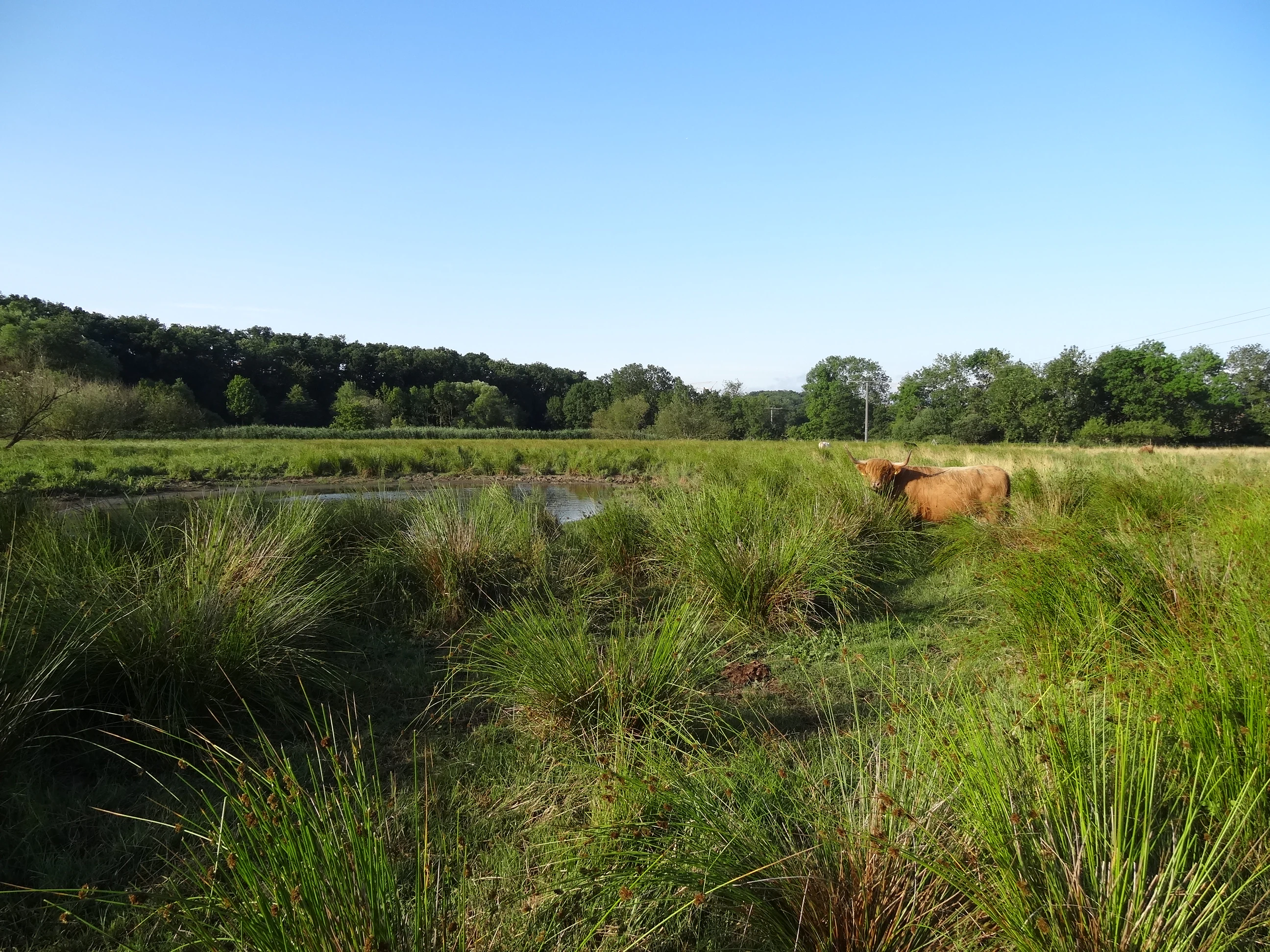
A wide shot of a green meadow with tall grasses, a small pond, and a brown cow standing on the right, backed by a line of trees under a clear blue sky.
A brown cow grazing in the moist meadows of the Breitwiese nature reserve, with a small pond and forest in the background.

Breitwiese bei Steinfurth und Oppershofen history and protected-area timeline

The area that is today the Breitwiese nature reserve has long been part of the Wetter floodplain landscape and was shaped by traditional flood meadow use. Modern protection began on 20 November 1990, when the area was formally designated as a Naturschutzgebiet by decree, establishing its official status as a habitat protection area under Hessian nature conservation law.

In 2009, Scottish Highland cattle were introduced onto the meadows as a conservation grazing measure, an approach intended to maintain open grassland structure and counteract scrub encroachment without relying solely on mechanical management. Since 2011, volunteers from the German nature conservation organization NABU have set up temporary amphibian protection fences each spring along the adjacent L 3134 road to reduce roadkill among migrating amphibians heading to their spawning waters.

A major recent step came in 2025, when the state road underwent a three-month full closure for resurfacing. As part of the works, eleven amphibian and small animal underpasses were installed along a 430-metre stretch, replacing the previous reliance on seasonal volunteer fencing with permanent infrastructure that allows wildlife to cross safely beneath the road throughout the year.

Breitwiese bei Steinfurth und Oppershofen landscape and geographic character

The landscape of Breitwiese is defined by the flat to gently undulating floodplain of the River Wetter, the small tributary and millrace system that borders it, and the surrounding agricultural matrix of the Wetterau. Topographically, the reserve sits low within a broader landscape of open fields, small villages, and historic transportation routes, which include both the present-day L 3134 state road and the now-defunct alignment of the Butzbach-Licher Eisenbahn.

The internal landscape is a fine-scale mosaic of wet meadows, damp low-lying ground, drier grassy areas, scrubby edges, and small open water features. The river itself and the Mühlgraben of the Oppershofen Nonnenmühle define the hydrological edge of the site, and seasonal flooding and groundwater influence the distribution of meadow types. The presence of Highland cattle adds a distinctive textural element to the scene, turning parts of the meadow into a lightly grazed, grassy pasture with visible trampling lines and short sward patches typical of natural grazing land.

Breitwiese bei Steinfurth und Oppershofen ecosystems, habitats, and plant life

Ecologically, Breitwiese represents a classic Wetterau wet meadow habitat, combining species-rich grassland, wet depressions, scrub margins, and water elements in close proximity. Its core ecological value lies in the fact that even though the protected area is small, it offers a layered combination of habitat types that few other locations in the surrounding farmland can provide simultaneously: shallow standing water or saturated soil for amphibians, tall herb and reed stands for insects and songbirds, and open short grass for ground-nesting birds.

The vegetation patterns reflect both natural hydrology and active conservation management. Wet meadow communities dominate the lower ground, while fallow areas and lightly grazed patches contribute structural diversity at the edges. The constant disturbance and sward shortening created by the Highland cattle prevent the dominance of a few competitive grasses and maintain space for wildflowers, invertebrates, and ground-nesting birds. The integration of the site into the European Wetterau bird protection area underlines its function within a much larger ecological network of floodplain habitats along the Wetter river system.

Breitwiese bei Steinfurth und Oppershofen wildlife and species highlights

Wildlife is the most visible expression of the reserve's ecological significance. The area is documented to host amphibians such as the common frog and smooth newt, and it serves as a seasonal spawning ground for populations that otherwise face high road mortality during their spring migrations.

The invertebrate fauna includes marsh grasshoppers among the more notable grasshopper species and the four-spotted chaser, a dragonfly typical of well-vegetated still waters. The birdlife combines breeding species such as lapwing, which requires open, lightly grazed ground for its nests, with reed-dwelling passerines like the reed bunting and other wetland-associated species including bluethroat. The common sandpiper, a wader tied to river edges, has also been recorded in the area. The mix of sedentary breeders, seasonal visitors, and migratory passage birds reflects the site's position within the larger Wetterau floodplain and connected bird protection area.

Breitwiese bei Steinfurth und Oppershofen conservation status and protection priorities

From a conservation perspective, Breitwiese is significant as a small but structurally rich refuge within a heavily cultivated agricultural region. Classified under IUCN Category IV (habitat/species management area), its designation reflects the recognition that even small floodplain fragments must be actively protected to preserve the species and ecological processes typical of the original Wetter river landscape.

The reserve sits within two overlapping protection frameworks: the regional Auenverbund Wetterau landscape protection area, which aims to maintain and reconnect floodplain habitats across the district, and the European Wetterau Natura 2000 bird protection area, which adds an international layer of obligation for the protection of relevant bird species.

Active conservation measures include the seasonal amphibian fencing program run by NABU volunteers since 2011 and the 2009 introduction of Scottish Highland cattle for conservation grazing. The 2025 installation of eleven permanent wildlife underpasses beneath the L 3134 marks another milestone, embedding road-wildlife mitigation directly into the transport infrastructure rather than relying solely on seasonal human effort.

Breitwiese bei Steinfurth und Oppershofen cultural meaning and human context

Breitwiese lies in a traditional farming landscape between the villages of Steinfurth and Oppershofen, both long-established settlements of the Wetterau. The presence of the historic Nonnenmühle millrace and the nearby alignment of the Butzbach-Licher Eisenbahn reflects the long interaction between human land use and the River Wetter, which has shaped the area's meadows, watercourses, and field structure over centuries.

Conservation at the site is also strongly community-based. The amphibian protection program is maintained by volunteer members of NABU, indicating an engaged local chapter that takes practical responsibility for the reserve. The use of Highland cattle as grazing animals, while originating in Scotland, has become a recognizable cultural symbol of contemporary German floodplain conservation, combining visible agricultural tradition with modern habitat management expectations.

Top sights and standout views in Breitwiese bei Steinfurth und Oppershofen

Breitwiese combines unusually compact ecological diversity with practical, multi-layered conservation management. A visitor or researcher encountering the site will find wet meadows, river edges, millrace margins, lightly grazed pasture, and small water bodies within walking distance of each other. The reserve is home to a recognizable suite of Wetterau floodplain species, including lapwing, bluethroat, reed bunting, common frog, smooth newt, marsh grasshopper, and four-spotted chaser.

Best time to visit Breitwiese bei Steinfurth und Oppershofen

Spring is the most ecologically active season at Breitwiese, when amphibians move toward their spawning waters and migrant and breeding birds are most active across the meadows. This is also the period when NABU volunteers erect amphibian fencing along the L 3134, making the seasonal dynamics of the reserve clearly visible. Summer offers the most accessible conditions for observing insects, dragonflies, and the grazing Highland cattle across open, dry meadow. Autumn and winter tend to be quieter, with reduced bird activity and more uniform grass cover, although the open landscape remains attractive for observing floodplain structure.

Monthly climate preview

Long-term monthly averages for representative park coordinates across the year

Breitwiese bei Steinfurth und Oppershofen Climate Normals and Temperature Rhythms

Historical data records tracked across thirty years demonstrate the annual temperature range and consistent daily precipitation patterns measured at a representative elevation point. Detailed monthly breakdowns provide deeper analytical perspective into long-term climate behavior across the entire protected terrain.
Annual mean9 °C
-1 °C19 °C
Jan-1°
Feb
Mar
Apr
May13°
Jun16°
Jul19°
Aug19°
Sep14°
Oct
Nov
Dec
Warmest month
July

18.8 °C

Coolest month
January

-0.6 °C

Wettest month
July

2.5 mm/day

Driest month
April

1.6 mm/day

Park location guide

Geography guide, regional context, and park location map for Breitwiese bei Steinfurth und Oppershofen

Breitwiese bei Steinfurth und Oppershofen park geography, regions, and map view in Germany

Understand where Breitwiese bei Steinfurth und Oppershofen sits in Germany through a broader geographic reading of the surrounding landscape, nearby location context, and its mapped position within the national park landscape.

How Breitwiese bei Steinfurth und Oppershofen fits into Germany

Germany is a federal republic in Western and Central Europe with a population of over 83 million across sixteen constituent states. It is Europe's largest economy by nominal GDP and a major global exporter and importer. The capital is Berlin, and the country borders Denmark, Poland, Czech Republic, Austria, Switzerland, France, Luxembourg, Belgium, and the Netherlands.

Wider geography shaping Breitwiese bei Steinfurth und Oppershofen in Germany

Germany is located in Western and Central Europe, spanning 357,022 km². It borders Denmark to the north, Poland and the Czech Republic to the east, Austria and Switzerland to the south, and France, Luxembourg, Belgium, and the Netherlands to the west. The country has coastlines on the Baltic Sea and North Sea to the north, with the Alps located in the southern region.

Map view of Breitwiese bei Steinfurth und Oppershofen

Use this park location map to pinpoint Breitwiese bei Steinfurth und Oppershofen in Germany, understand its exact geographic position, and read its mapped placement within the surrounding landscape more clearly.

Pigeon | © OpenStreetMap contributors

Location context for Breitwiese bei Steinfurth und Oppershofen

Wetteraukreis

Visualizing the wet meadows, river floodplains, and conservation grazing habitats

Breitwiese bei Steinfurth und Oppershofen Photos and Landscape Scenery

Visual records capture the flat floodplain terrain, wetland habitats, and open grassland mosaic of Breitwiese bei Steinfurth und Oppershofen. Photographic documentation reveals the environmental character of the protected river margins and grazed pastures.

A wide shot of a green meadow with tall grasses, a small pond, and a brown cow standing on the right, backed by a line of trees under a clear blue sky.

Park atlas

Compare surrounding regional floodplain reserves and connected conservation landscapes.

Other Parks and Protected Areas Near Breitwiese bei Steinfurth und Oppershofen

Browsing other protected areas near Breitwiese bei Steinfurth und Oppershofen reveals connected floodplain habitats and regional wetland ecosystems across Hesse. Extending geographic comparison highlights similar conservation sites within the wider Wetterau agricultural basin.
A wide watercolor painting showing a green river valley with marshy foreground, a line of trees, and rolling hills in purple and green in the background.
Nature reserveWetteraukreis
About 2.2 km away#1 closest

South

Salzwiesen von Wisselsheim Nature Reserve: Atlas and Regional Geography of Wetteraukreis

Protected inland salt meadows and floodplain geography in Hesse, Germany.

Salzwiesen von Wisselsheim stands as a significant protected area in the Wetteraukreis region, distinguished by rare inland salt meadows fed by natural saline springs. This reserve presents a compelling landscape defined by the River Wetter, offering deep insights into how unique hydrogeology and historical salt production have formed a specialized lowland habitat that is largely absent from other inland regions.

Area
0.23 km²
Established
1982
Relief
Lowland
Climate
Temperate
A watercolor painting showing a soft, peaceful landscape with green rolling hills, a small body of water in the foreground, and faint, distant mountains under a pale sky.
Nature reserveHesse
About 2.3 km away#2 closest

South

Kiesgrube Laukertsberg bei Nieder-Mörlen Protected Area in Hesse, Germany

A reclaimed post-industrial nature reserve and habitat

Located in the Wetterau district of Hesse, Kiesgrube Laukertsberg bei Nieder-Mörlen represents a significant shift from industrial gravel extraction to protected ecological sanctuary. The terrain features open-ground habitats and seasonal wetlands that support sensitive species, illustrating how landscape management can prioritize biodiversity. Analyze the site boundaries and its role within the broader regional geography of central Germany.

Area
0.157 km²
Established
2019
IUCN
IV
Relief
Lowland
Protected areaGermany
About 5.1 km away#3 closest

Southwest

Magertriften von Ober-Mörlen und Ostheim Protected Area Geography and Map

A vital nutrient-poor grassland refuge in Hesse, Germany

Located in the Wetteraukreis district, the Magertriften von Ober-Mörlen und Ostheim protected area preserves a rare, species-rich grassland habitat on base-rich soils. This 77-hectare reserve, integrated into the Natura 2000 network, offers a stark contrast between its preserved dry-grassland ecosystems and the surrounding agricultural and industrial transport landscape of central Germany.

Area
0.775 km²
Established
1990
Relief
Lowland
Scope
Terrestrial
A horizontal watercolor painting showing a wetland landscape with gentle rolling hills, marshy vegetation, and scattered trees under a light sky.
Nature reserveHesse
About 11 km away#4 closest

East

Bingenheimer Ried Nature Reserve: Mapped Floodplain Geography in Hesse

A critical lowland mire and wetland conservation network

Located in the Horloff valley, Bingenheimer Ried represents an essential protected landscape characterized by seasonal flooding and shallow mire habitats. This nature reserve supports significant bird populations and diverse aquatic life, functioning as a primary reference point for floodplain management and conservation geography within the state of Hesse.

Area
0.85 km²
Established
1985
A horizontal watercolor illustration showing a meandering stream flowing through open green grasslands with scattered trees and low hills in the background.
Nature reserveHessen
About 15 km away#5 closest

Southeast

Nachtweid von Dauernheim Nature Reserve: Geographic Overview and Wetland Conservation

Saline meadows and floodplain habitats in Hessen

Nachtweid von Dauernheim is a specialized nature reserve in the Wetterau district, defined by its rare saline-influenced grassland flora and extensive sedge marshes. As a core rail bird biotope, the site anchors a wider wetland network alongside the Nidda river floodplain. This protected area offers a deep look into central Germany's unique hydrologic conditions and sensitive open-terrain conservation.

Area
0.789 km²
Established
1978
A watercolor illustration of a gentle valley landscape with rolling green hills, scattered trees, and a small stream meandering through the center.
Nature reserveHesse
About 16 km away#6 closest

Southwest

Röllbachtal bei Usingen: A Protected Stream Valley and Nature Reserve in Hesse

Mapping riparian restoration and low mountain valley habitats

Röllbachtal bei Usingen represents a key protected landscape in the Eastern Hintertaunus of Germany. The nature reserve manages a narrow stream corridor characterized by alder and ash riparian forests, wet meadows, and tall herb floodplain vegetation. This area provides a clear view into the successful restoration of valley habitats and the broader network of protected natural spaces across the Hochtaunuskreis region.

Area
0.739 km²
Established
1999
Relief
Upland
Climate
Temperate
A watercolor painting showing a soft, pastoral landscape with green trees, rolling hills, and purple-toned wetland areas against a white background.
Nature reserveHessen
About 18 km away#7 closest

Northwest

Egelpfuhl bei Oberwetz Nature Reserve: A Protected Wetland Sanctuary in Hessen, Germany

Geographic overview of a protected wet meadow valley in the Lahn-Dill district.

Egelpfuhl bei Oberwetz occupies a 10.75-hectare valley hollow defined by its moist soils and near-natural brook course. This nature reserve supports a structured habitat for endangered meadow butterflies and birds, acting as an essential ecological bridge within the intensively farmed landscape of central Germany.

Area
0.108 km²
Established
1990
IUCN
IV
Watercolor painting of a green landscape with rolling hills, small clusters of trees, and soft pinkish tones in the background.
Nature reserveHesse
About 19 km away#8 closest

Southeast

Krebsbachtal bei Kaichen: Protected Stream Valley Geography and Landscape Map in Hesse

Nature reserve featuring diverse meadow and forest habitat mosaics

Spanning 34 hectares in the Main-Kinzig-Kreis, the Krebsbachtal bei Kaichen reserve protects a unique concentration of riparian stream life, dry grasslands, and traditional orchard meadows. This valley landscape, framed by the Hainwald forest, provides a protected corridor that remains a significant representative of the historic natural terrain found in central Hesse.

Area
0.34 km²
Established
1988
Relief
Lowland
Climate
Temperate

Common questions about visiting, size, designation, and location context for Breitwiese bei Steinfurth und Oppershofen

Breitwiese bei Steinfurth und Oppershofen FAQs for park facts, access, geography, and protected area context

Find quick answers about Breitwiese bei Steinfurth und Oppershofen, including protected-area facts, park geography, trail and visitor context, and how the park fits into its surrounding country and regional landscape.
MoriAtlas Explorer

Continue Your Protected Areas Search Across the Global Atlas

Deepen your exploration by continuing the structured search for national parks and protected areas worldwide. Utilize the comprehensive filtering capabilities to compare different conservation landscapes and refine your understanding of global park geography. Discover more about the distribution and characteristics of protected natural areas.

Global natural geography