
Mori Atlas logo
Nature reserveBroulee Island Nature Reserve

A study of coastal island geomorphology and tidal rock platforms on the NSW South Coast

Broulee Island Nature Reserve: Coastal Geography and Protected Land Mapping in New South Wales

Broulee Island Nature Reserve stands as a distinct protected landscape on the South Coast of New South Wales, defined by its small island character and the natural sand tombolo that bridges the reserve to Broulee Head. This 43-hectare coastal environment provides a focused study in marine geology, featuring exposed rocky shorelines, tidal pools, and native dune vegetation. Through detailed map-based analysis, the reserve reveals how shifting sands and sea levels shape the territorial connection between isolated coastal outcrops and the mainland shelf.

south coastcoastal islandnature reserveNSWtombolorocky shoreline
A flat-style digital illustration showing a coastline with green hills, cliffs meeting the ocean, a small sandy beach, and foreground trees under a soft-colored sky.

Broulee Island Nature Reserve

Nature reserve

Park overview

Structured park overview, official facts, and landscape profile for Broulee Island Nature Reserve

Broulee Island Nature Reserve park facts, protected area profile, and essential visitor context

Review the core facts for Broulee Island Nature Reserve, including designation, size, terrain, visitor scale, habitats, and operating context in one park-focused overview.

About Broulee Island Nature Reserve

Broulee Island Nature Reserve is a modest but distinctive protected area on the South Coast of New South Wales. It is located just offshore from the village of Broulee, roughly 23 kilometres south of Batemans Bay, and forms part of the broader Eurobodalla Shire. The reserve encompasses around 43 hectares of coastal island terrain, a small footprint that nonetheless captures a varied transition between rock platform, beach, dune, and tidal environment typical of this stretch of the NSW coastline.

The reserve was gazetted in April 1972 and has been managed continuously by the NSW National Parks and Wildlife Service since that time, placing it among the longer-established small protected areas of the South Coast. Although it is small, the site carries local significance as a long-protected coastal island habitat close to population centres, giving it an accessible role in the regional network of protected landscapes.

A defining feature of the reserve is its evolving coastal geomorphology. Originally separated from the mainland by a shallow channel, Broulee Island has, over time, become joined to the mainland by a sand tombolo that now links the island to Broulee Head. This natural connection reshapes how the landscape is read from both the shore and aerial views, while reinforcing the importance of the reserve as a place where sand movement, tidal action, and rocky shoreline interact within a small area.

The island combines exposed rock platforms with stretches of sand, dunes, and low coastal vegetation, set against views northward toward Burrewarra Point and Burri Point. In addition to its natural values, the reserve sits within the boundaries of the Mogo Local Aboriginal Land Council, placing it within a recognised Indigenous cultural landscape alongside its formally protected environmental status. Together, these qualities make Broulee Island Nature Reserve a small but representative example of NSW South Coast coastal island conservation.

Quick facts and research context for Broulee Island Nature Reserve

Broulee Island Nature Reserve is a protected nature reserve on the south coast of New South Wales, managed by the NSW National Parks and Wildlife Service. It lies adjacent to the village of Broulee, about 23 kilometres south of Batemans Bay, within Eurobodalla Shire and the Mogo Local Aboriginal Land Council area.

Protection and recognition

Documented protection history, management scope, and official designation records

Broulee Island Nature Reserve Protection Status and Terrestrial Conservation Scope

Terrestrial protection status for Broulee Island Nature Reserve covers documented conservation boundaries and management parameters. Official designation records outline baseline protected area data without relying on external recognition sources.

Protection details

Protection scope
Terrestrial
Transboundary protection
No
Park context

Deeper park guide and search-rich context for Broulee Island Nature Reserve

Broulee Island Nature Reserve history, landscape, wildlife, and travel context

Explore Broulee Island Nature Reserve through its history, landscape character, ecosystems, wildlife, conservation priorities, cultural context, and seasonal travel timing in a structured park guide built for atlas discovery and search intent.

Why Broulee Island Nature Reserve stands out

The reserve is best known for its small offshore island character and the sand tombolo that now joins it to the mainland at Broulee Head, forming a distinctive coastal landscape feature on the NSW South Coast. It is also associated with tidal rock platforms, native coastal flora, and opportunities to observe shorebirds and other coastal wildlife in a compact setting.
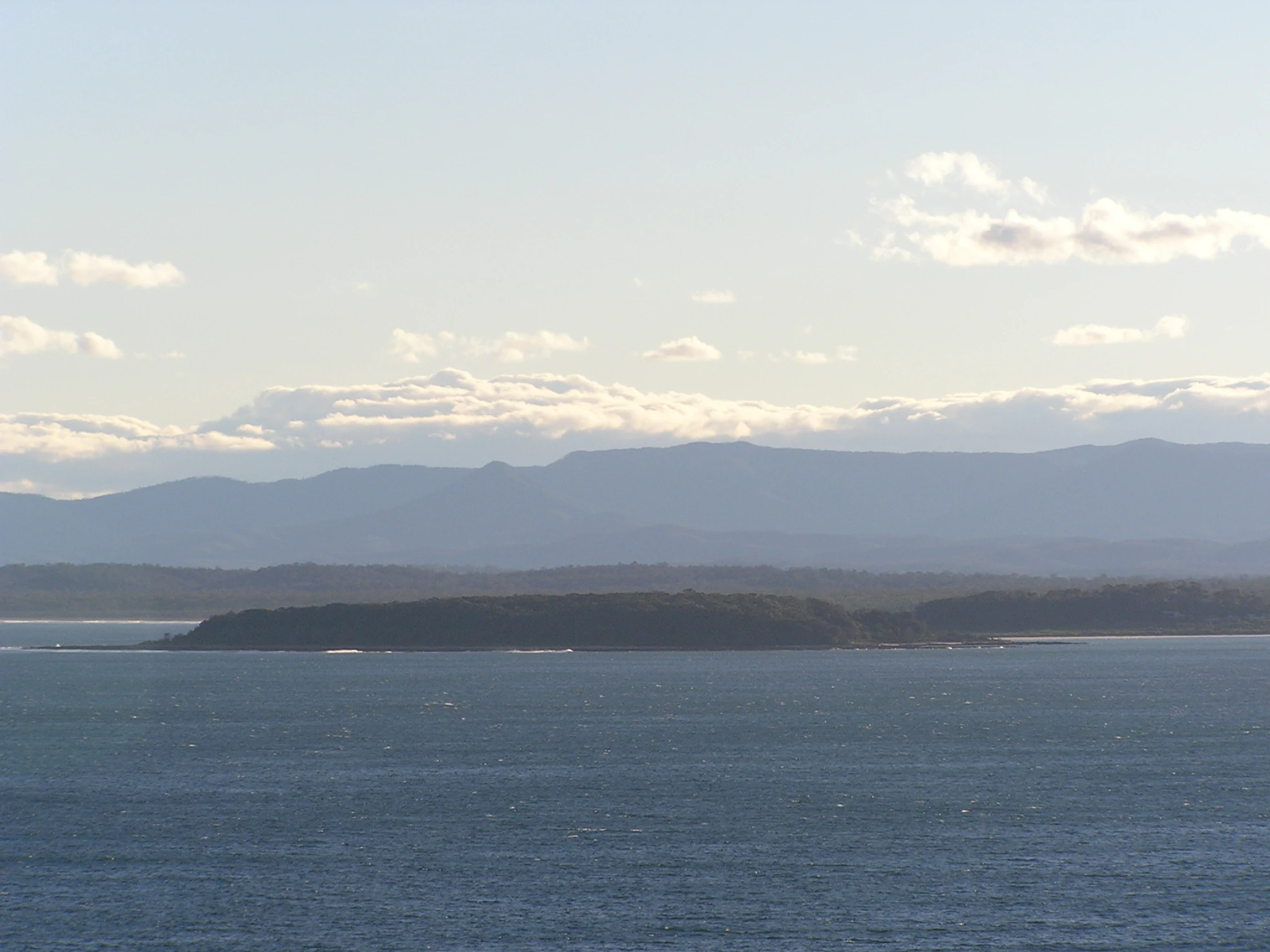
A wide coastal view of Broulee Island appearing as a dark, tree-covered landmass separated from the mainland, with ocean in the foreground and a hazy mountain range in the far background.
A view of Broulee Island from the coast, showing the island's low-lying profile against a backdrop of distant hills.

Broulee Island Nature Reserve history and protected-area timeline

Broulee Island Nature Reserve was formally gazetted in April 1972, extending long-standing protection to a coastal island south of Batemans Bay. Earlier human activity on and around the island is recorded in the 1920s, when a small port operated here and a notable quantity of shell grit was shipped to Sydney, where it was processed into lime for use in construction. This early industrial use links the island to a broader history of small-scale coastal resource extraction along the South Coast.

The creation of the reserve in the early 1970s placed the island under formal stewardship by what is now the NSW National Parks and Wildlife Service. Since then, the site has remained a continuously protected nature reserve within the state's system. A more recent and visible chapter in the reserve's history has been physical rather than institutional: by July 2008, a sand tombolo had formed between Broulee Island and the mainland at Broulee Head, effectively joining the once-separate island to the shore and changing how visitors and managers experience the landscape.

Broulee Island Nature Reserve landscape and geographic character

The landscape of Broulee Island Nature Reserve is shaped by the meeting of rock, sand, and sea. The reserve includes rocky shoreline sections with tidal platforms and pools, contrasted by stretches of beach and mobile sand. The unifying feature is the tombolo that now links the island to the mainland at Broulee Head, a geomorphological development that has softened the visual separation between island and shore.

From the sand spit, views open north-east toward Burrewarra Point, while other vantage points, including Burri Point, allow broad outlooks along the South Coast. The terrain is generally low and undulating, dominated by exposed rock, dune formations, and small beach pockets rather than substantial elevation. This compact mix of coastal landforms gives the reserve a strong sense of contrast in a small area, where rocky outcrops, tidal pools, dune vegetation, and shifting sand can all be encountered within a short walking distance.

The overall impression is of a small but texturally varied coastal island landscape, anchored by its connection to the mainland and framed by the broader sweep of the NSW South Coast.
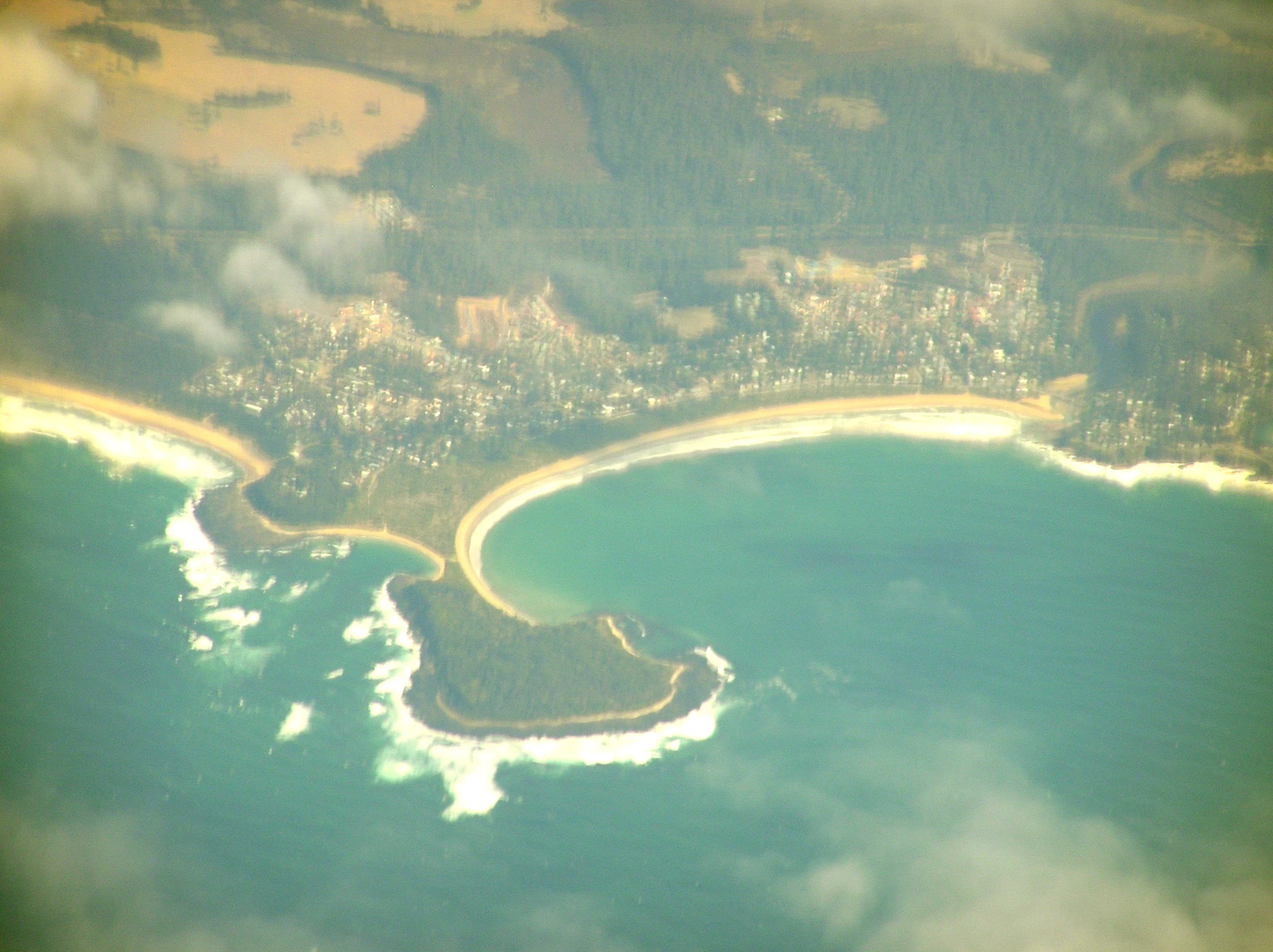
An aerial perspective of Broulee Island, showing the tombolo sandbar connecting the island to the mainland near a coastal town.
Aerial view of the Broulee Island tombolo and surrounding coastline.

Broulee Island Nature Reserve wildlife and species highlights

Wildlife interest at Broulee Island Nature Reserve centres on the birds and other animals supported by its rocky shoreline, tidal pools, dune vegetation, and coastal scrub. The reserve is associated with opportunities to see species typical of the NSW South Coast coast, including sea eagles and smaller wrens, which use the mix of rock platforms, shrubs, and adjacent sea for feeding and shelter.

The presence of intact tidal pools and relatively undisturbed rock platforms means the reserve can host typical invertebrate life of these habitats, while the dune and scrub vegetation offers cover for smaller birds and ground-dwelling fauna. Although the reserve is small, its combination of sea, sand, rock, and vegetation creates a useful range of microhabitats for coastal wildlife within a compact footprint.

While detailed species inventories are limited in publicly available sources, the reserve clearly functions as a local refuge and foraging area for shorebirds and seabirds, reinforcing its role within the broader coastal wildlife network of the Eurobodalla region.

Broulee Island Nature Reserve conservation status and protection priorities

Broulee Island Nature Reserve has carried formal protection since 1972, placing it among the longer-established small reserves on the NSW South Coast. Its long-standing status as a nature reserve under NSW National Parks and Wildlife Service management reflects recognition of its value as a coastal island habitat, despite its modest size of around 43 hectares.

From a conservation perspective, the reserve matters because it safeguards a connected coastal environment where rock platform, dune, beach, and tidal habitats occur together in a small area. Its protected status also helps maintain a buffer of natural coastline adjacent to the developed areas around the village of Broulee and the broader Batemans Bay region, supporting both habitat continuity and water quality along this stretch of coast.

The reserve's location within the Mogo Local Aboriginal Land Council area adds a further dimension to its conservation context, positioning it within a culturally recognised landscape as well as an ecologically significant one.

Broulee Island Nature Reserve cultural meaning and human context

Broulee Island Nature Reserve sits within the boundaries of the Mogo Local Aboriginal Land Council, situating the protected area within a recognised Indigenous cultural region on the NSW South Coast. This overlap between formal environmental protection and Aboriginal land council boundaries gives the reserve a dual identity as both a nature reserve and part of a living cultural landscape.

In addition to its Indigenous cultural setting, the island has a documented twentieth-century history of small-scale coastal industry. In the 1920s, a small port operated on or near the island, exporting shell grit to Sydney for use in lime production and construction. This phase of use reflects the wider history of South Coast coastal resources being drawn upon for building materials in growing urban centres, and it adds a layer of human history to an otherwise predominantly natural landscape.

Top sights and standout views in Broulee Island Nature Reserve

Broulee Island Nature Reserve is a small but visually striking protected island on the NSW South Coast, distinguished by the sand tombolo that now joins it to the mainland at Broulee Head. Its mix of rocky platforms, tidal pools, dune vegetation, and exposed shoreline offers a compact but varied coastal experience close to the village of Broulee and Batemans Bay. The reserve also stands out for its long protection history, dating to 1972, and for its location within the Mogo Local Aboriginal Land Council area, linking natural and cultural values in a single small reserve.

Best time to visit Broulee Island Nature Reserve

The South Coast climate around Broulee is generally mild, and the reserve can be appreciated across much of the year. Warmer months tend to highlight the rock pools, dune vegetation, and beach character of the island, while cooler and quieter periods can make wildlife observation along the shore platforms more comfortable. As with any small coastal reserve, conditions vary with tides and weather, and the tombolo connection to the mainland can shift the way the landscape is experienced at different times.

Monthly climate preview

Long-term representative temperature and precipitation metrics across the year

Broulee Island Nature Reserve Climate Normals and Annual Weather Patterns

Representative coordinate records show measured average temperatures ranging from 10.23 degrees Celsius to 20.84 degrees Celsius alongside steady monthly precipitation levels. Analyzing the full twelve-month profile provides complete historical averages for temperatures and precipitation patterns across the reserve.
Annual mean16 °C
10 °C21 °C
Jan21°
Feb20°
Mar19°
Apr16°
May13°
Jun11°
Jul10°
Aug11°
Sep13°
Oct15°
Nov17°
Dec19°
Warmest month
January

20.8 °C

Coolest month
July

10.2 °C

Wettest month
February

3.8 mm/day

Driest month
July

1.6 mm/day

Park location guide

Geography guide, regional context, and park location map for Broulee Island Nature Reserve

Broulee Island Nature Reserve park geography, regions, and map view in Australia

Understand where Broulee Island Nature Reserve sits in Australia through a broader geographic reading of the surrounding landscape, nearby location context, and its mapped position within the national park landscape.

How Broulee Island Nature Reserve fits into Australia

Australia is a constitutional monarchy and federal parliamentary democracy comprising six states and ten territories. With a population of nearly 28 million, it is one of the world's most urbanised countries, with most people concentrated on the eastern seaboard. The country has a high Human Development Index and is known for its cultural diversity, ancient Aboriginal heritage, and unique wildlife.

Wider geography shaping Broulee Island Nature Reserve in Australia

Australia occupies the entire Australian continent, the island of Tasmania, and numerous smaller islands. It is the world's flattest and driest inhabited continent, featuring vast deserts in the interior (the Outback), tropical rainforests along the eastern coast, and a coastline bordering the Indian and Pacific Oceans.

Map view of Broulee Island Nature Reserve

Use this park location map to pinpoint Broulee Island Nature Reserve in Australia, understand its exact geographic position, and read its mapped placement within the surrounding landscape more clearly.

Pigeon | © OpenStreetMap contributors

Location context for Broulee Island Nature Reserve

New South Wales

Visual reference for coastal island terrain, rocky shores, and tidal habitats

Broulee Island Nature Reserve Photos, Scenery, and Coastal Landscapes

Visual records reveal the distinctive coastal landscape of Broulee Island Nature Reserve, capturing tidal rock platforms, dune vegetation, and the connecting sand tombolo. Photographic documentation provides clear insight into the protected island environment, illustrating terrain features and coastal habitats along the New South Wales South Coast.

A wide coastal view of Broulee Island appearing as a dark, tree-covered landmass separated from the mainland, with ocean in the foreground and a hazy mountain range in the far background.

A wide panoramic view of a wooded island surrounded by blue ocean, viewed across a sandy spit and coastal vegetation on a clear day.

An aerial perspective of Broulee Island, showing the tombolo sandbar connecting the island to the mainland near a coastal town.

Park atlas

Compare nearby protected areas and regional coastal terrain along the South Coast

Exploring Parks Near Broulee Island Nature Reserve and Surrounding Coastal Landscapes

Visitors exploring Broulee Island Nature Reserve can discover other coastal protected areas and marine reserves situated along the surrounding regional coastline. Comparing adjacent conservation landscapes provides valuable geographic context for understanding the wider New South Wales protected network.
Watercolor painting showing green hills, valleys, and distant mountains
National parkNew South Wales
About 6 km away#1 closest

South

Eurobodalla National Park: New South Wales Coastal Protected Landscape and Geographic Atlas

Explore its mapped protected boundaries and unique estuarine wetland habitats.

Eurobodalla National Park represents a critical segment of the New South Wales coastline, distinguished by its designation as a national park. The park's geography is characterized by a mosaic of coastal terrains, including sandy shores, river estuaries, and vegetated headlands, which collectively form essential protected landscapes. It is particularly recognized for its role in supporting migratory bird populations and serves as a key site for understanding coastal ecology and conservation efforts within Australia. Through its mapped protected areas, Eurobodalla National Park provides valuable insights into the regional geography and the distribution of vital natural habitats.

Area
29.13 km²
Established
1995
IUCN
II
Relief
Lowland
National parkNew South Wales
About 16 km away#2 closest

Northeast

Murramarang National Park: Discover Its Mapped Protected Area and New South Wales Geography

Explore the unique landscape and geographic features.

Murramarang National Park stands as a distinct protected area within New South Wales, offering a unique landscape to explore through its mapped boundaries and regional geographic context. This resource provides essential details for understanding its place in the atlas of Australian protected lands. Users can gain a factual appreciation of the park's physical geography and its identity as a national park, grounded in spatial data and mapped terrain.

Area
121 km²
Established
1973
IUCN
II
Relief
Mountain
National parkNew South Wales
About 17 km away#3 closest

West

Deua National Park: New South Wales National Park Exploration and Map Context

Discover protected landscape boundaries and regional geography.

Deua National Park offers a focused lens into Australia's protected areas, specifically within the state of New South Wales. This page provides detailed geographic context, enabling users to trace the park's boundaries and understand its position within the regional atlas. Explore the mapped terrain and the protected landscape identity that defines Deua National Park as a key component of conservation efforts in the area, ideal for a structured understanding of protected natural spaces.

Area
1,220 km²
Established
1979
IUCN
Ib
Relief
Mountain
National parkAustralia
About 18 km away#4 closest

North

Clyde River National Park: Australia's Protected Riverine Landscape and Swift Parrot Sanctuary

Discover its vital role in conservation and mapped geography.

Clyde River National Park is a critical protected area in Australia, safeguarding nine kilometers of river frontage along the Clyde River. Established for its ecological importance, particularly as a sanctuary for the endangered swift parrot, the park's landscape is characterized by riverine forests and eucalyptus woodlands. This designation highlights its role in preserving key habitats and contributing to the regional map of protected lands vital for biodiversity.

Area
10.91 km²
Established
2000
IUCN
II
Scope
Terrestrial
Watercolor illustration of green hills, pink and purple floral elements, a body of water, and a soft sky.
National parkNew South Wales
About 29 km away#5 closest

Northwest

Monga National Park: New South Wales National Park Protected Area Map and Geography

Discover the landscape context and mapped boundaries of this national park.

Delve into the protected landscape of Monga National Park, a designated national park situated in New South Wales, Australia. This page offers detailed insights into its geographic positioning, mapped protected area boundaries, and its role within the regional atlas. Understand the park's natural terrain and its significance as a protected natural area, contributing to a comprehensive geographic understanding.

Area
251.44 km²
Established
2001
IUCN
II
Relief
Upland
National parkNew South Wales
About 37 km away#6 closest

North

Bimberamala National Park: New South Wales National Park Protected Landscape Atlas

Mapped boundaries and regional geographic context for discovery.

Bimberamala National Park is a protected natural area within New South Wales, Australia, offering a distinct geographic profile. As a national park, its mapped boundaries and landscape characteristics are valuable for understanding regional protected areas and their distribution. This entity provides a focused point for atlas-based geographic exploration, allowing users to study its specific terrain and environmental context within the wider Australian geography.

Area
43.96 km²
Established
2001
IUCN
II
Relief
Upland
National parkNew South Wales
About 38 km away#7 closest

North

Budawang National Park: Wilderness Area and Rugged Terrain Map

Discover New South Wales protected landscape geography.

Budawang National Park is recognized for its exceptional wilderness character, defined by the steep topography of the southern Budawang Range. This protected national park features extensive cool temperate rainforests clothing its middle and upper slopes, creating a visually striking and ecologically rich mountain environment. Its rugged terrain, with deep valleys and rocky outcrops, distinguishes it as a remote natural landscape within New South Wales, offering unique habitat pockets and contributing to the region's protected area atlas.

Area
237 km²
Established
1977
IUCN
Ib
Relief
Mountain
A soft watercolor painting of a coastline featuring gentle green hills on the sides, calm water in the center, and pale, misty islands in the background under a warm, diffused sky.
Nature reserveNew South Wales
About 42 km away#8 closest

Northeast

Brush Island Nature Reserve: Mapping the Protected Landscape and Seabird Terrain of New South Wales

Offshore island conservation area and rocky coastal habitat in the Tasman Sea.

Brush Island Nature Reserve is a small but ecologically significant protected area located off the South Coast of New South Wales. Defined by its steep cliffs and gullies, the island provides critical nesting ground for seabird populations. This entry provides a structured look at the island's physical boundaries, its status as a strict nature reserve, and its regional geographic context.

Area
0.47 km²
Established
1963
IUCN
Ia
Relief
Lowland

Common questions about visiting, size, designation, and location context for Broulee Island Nature Reserve

Broulee Island Nature Reserve FAQs for park facts, access, geography, and protected area context

Find quick answers about Broulee Island Nature Reserve, including protected-area facts, park geography, trail and visitor context, and how the park fits into its surrounding country and regional landscape.
MoriAtlas Explorer

Continue Your Protected Areas Search Across the Global Atlas

Deepen your exploration by continuing the structured search for national parks and protected areas worldwide. Utilize the comprehensive filtering capabilities to compare different conservation landscapes and refine your understanding of global park geography. Discover more about the distribution and characteristics of protected natural areas.

Global natural geography