Mori Atlas logo
Protected areaBuir Lake

Tracing the transboundary hydrology and continental steppe margins of a major Ramsar site.

Buir Lake Protected Area: Steppe Landscapes and Mapped Wetland Geography in Eastern Mongolia

(Lake Buir and its surrounding wetlands)

Buir Lake represents a significant freshwater basin straddling the border between Mongolia and China. This protected area within Dornod Province encompasses expansive wetland zones and low relief steppe plains, serving as a critical habitat for migratory waterbirds. The surrounding landscape is defined by its shallow hydrology and gradual transition from open water to dry meadow, reflecting the complex ecological character of the eastern continental interior.

transboundary lakefreshwater lakesteppe wetlandsRamsar sitemigratory waterbirdsChina-Mongolia border

Buir Lake

Protected area

Park overview

Structured park overview, official facts, and landscape profile for Buir Lake

Buir Lake park facts, protected area profile, and essential visitor context

Review the core facts for Buir Lake, including designation, size, terrain, visitor scale, habitats, and operating context in one park-focused overview.

About Buir Lake

Buir Lake is a shared freshwater body that forms a natural boundary feature on the China-Mongolia frontier. The western portions of the lake belong to Mongolia's eastern Dornod Province, while the eastern shore and catchment extend into China's Inner Mongolia, where the regional city of Hulunbuir sits. The lake lies within the Buir Lake Depression, a low-relief landscape that determines its shallow profile and the character of its fringing wetlands.

The surrounding terrain is typical of the eastern Mongolian steppe, transitioning from open grasslands and meadow-steppe near the lake into drier continental environments further inland. These wetlands and shallow waters create habitat conditions that are disproportionately valuable in the regional context, where freshwater environments are otherwise limited and seasonally variable.

Buir Lake's ecological significance has been formally recognized through its designation in 2004 under the Ramsar Convention as 'Lake Buir and its surrounding wetlands,' listing it as a wetland of international importance, particularly for waterbird populations that use the lake and its margins at different stages of the year.

Equally important is the lake's place in regional history. In 1388, Ming forces under General Lan Yu defeated the Northern Yuan at the Battle of Buyur Lake near Buir Lake, a turning-point encounter that ended with the death of the Northern Yuan ruler Tögüs Temür. This long historical layer, combined with the lake's role as a shared natural landmark, gives Buir Lake a dual identity as both an ecological site and a historical anchor in the memory of the broader steppe region.

Quick facts and research context for Buir Lake

Buir Lake is a shared transboundary freshwater lake between Mongolia (Dornod Province) and China (Hulunbei'er in Inner Mongolia), set within the Buir Lake Depression. It has been designated a Ramsar Wetland under the official name 'Lake Buir and its surrounding wetlands' since 22 March 2004, reflecting its importance for migratory waterbirds and wetland habitat in the eastern Mongolian steppe.

Protection and recognition

Documented conservation scope, designation history, and Ramsar wetland status

Buir Lake Protection Status and International Recognition Data

Terrestrial protection status for Buir Lake includes official designation history dating back to 2004 alongside international recognition as a Ramsar site. Structured records outline the documented management scope and transboundary context for this protected natural area.

International recognition

Protection details

Protection scope
Terrestrial
Designated year
2004
Transboundary protection
Yes
Park context

Deeper park guide and search-rich context for Buir Lake

Buir Lake history, landscape, wildlife, and travel context

Explore Buir Lake through its history, landscape character, ecosystems, wildlife, conservation priorities, cultural context, and seasonal travel timing in a structured park guide built for atlas discovery and search intent.

Why Buir Lake stands out

Buir Lake is best known as a large freshwater steppe lake marking the China-Mongolia border, and for its surrounding wetlands that support migratory waterbirds and have earned Ramsar recognition. The lake also carries strong historical resonance as the site of the 1388 Ming-era Battle of Buyur Lake, and it shares its name with the broader Hulunbuir region on the Chinese side.

Buir Lake history and protected-area timeline

The most prominent historical event associated with Buir Lake is the Battle of Buyur Lake in 1388. During this campaign, Ming dynasty forces commanded by General Lan Yu engaged the Northern Yuan on the steppes near the lake. The Ming victory was decisive, opening a path into the Northern Yuan heartland, and the Northern Yuan ruler Tögüs Temür was killed shortly after the battle while attempting to escape, effectively marking the end of major Northern Yuan military power in the region.

In the modern era, the lake's ecological significance became the focus of conservation attention. In 2004, Buir Lake and its associated wetlands were formally designated under the Ramsar Convention as a wetland of international importance under the official title 'Lake Buir and its surrounding wetlands.' This recognition underscored the lake's role as a refuge for migratory waterbirds and a representative example of steppe wetland habitat in a region where standing freshwater is ecologically valuable.

The lake continues to act as a shared natural boundary marker between Mongolia and China, and its names have shaped the regional cultural geography on the Chinese side, where the city of Hulunbuir is named not only after Buir Lake but also after the nearby Hulun Lake further to the east.

Buir Lake landscape and geographic character

Buir Lake sits within the Buir Lake Depression, a broad, low-relief basin that defines the lake's setting in the eastern Mongolian steppe. The terrain surrounding the lake is dominated by open grasslands and meadow-steppe, transitioning into the wider continental steppe environment. The depressions and shallow gradients around and beneath the lake create the conditions for a shallow, seasonally influenced freshwater body rather than a deep, steep-sided lake.

The lake's margins are fringed by wetland zones that blend gradually into the surrounding steppe. This gradual transition from open water to wet meadow, marsh, and dry grassland gives the area a soft, layered look, with changing water levels influencing the visible extent of shore habitat over the year. On the Chinese side, the lake's catchment links into the broader Inner Mongolian steppe and the neighboring Hulun Lake system, giving the regional landscape a connected feel.

There are no dramatic mountain peaks or steep escarpments immediately defining Buir Lake. Instead, the landscape is defined by horizon, by the interplay of water and steppe, and by the way the margins of the depression grade into wetland and dry plains. This understated character is central to the lake's visual identity.

Buir Lake ecosystems, habitats, and plant life

The defining ecological characteristic of Buir Lake is the combination of open freshwater habitat with extensive surrounding wetlands, all set within a steppe landscape that is otherwise dominated by drier grassland. This makes the lake and its associated wetlands a comparatively rich habitat island in the regional mosaic, supporting species groups that depend on standing water, shallow margins, and emergent vegetation.

The hydrology of the lake and depression is seasonally variable, influenced by snowmelt, summer rainfall, and evaporation across the broad basin. These seasonal fluctuations shape the extent and character of the wetland fringe, with wetter years offering broader marshy conditions and drier years exposing more open shoreline. This natural dynamism is itself part of the ecological value of the site.

The broader vegetation patterns around the lake transition from wet meadow and marsh communities along the immediate shoreline into drier steppe grassland further inland. This gradient supports a variety of habitat niches across a relatively compact area, which in turn supports the bird and animal communities for which the lake is particularly important.

Buir Lake wildlife and species highlights

Buir Lake's wildlife value is centered on its importance for migratory waterbirds that use the lake and its surrounding wetlands during different parts of the annual cycle. The combination of open freshwater, shallow margins, emergent vegetation, and adjacent steppe grassland creates habitat for breeding, staging, and migrating populations of waterfowl, waders, and other wetland-associated bird groups.

The lake's designation as a Ramsar Wetland underscores its role in supporting these migratory waterbird populations, which depend on stopover sites across the east Asian and central Asian flyways. Outside of the breeding and migration seasons, the surrounding steppe continues to host typical eastern Mongolian steppe fauna adapted to grassland conditions.

Because the lake sits at the meeting point of two national jurisdictions, wildlife monitoring and protection are shared responsibilities between the Mongolian and Chinese sides, with the lake's ecological role extending across the border rather than being contained within a single national framework.

Buir Lake conservation status and protection priorities

The principal conservation significance of Buir Lake is its formal recognition under the Ramsar Convention. In 2004, the site was designated as a Ramsar Wetland of International Importance under the official name 'Lake Buir and its surrounding wetlands,' identifying it as a priority wetland for waterbird conservation in the region.

This designation reflects the lake's ecological role as a key freshwater and wetland site in an area where such habitats are otherwise scarce. By protecting not just the open water of the lake but also its surrounding wetlands, the Ramsar listing acknowledges the integrated habitat complex that gives Buir Lake its biological value, including the marshy margins and connected meadow-steppe that support migratory waterbirds.

As a transboundary site, Buir Lake's conservation relies on cooperation between Mongolia and China. The shared nature of the lake means that wetland health, water levels, and habitat condition on one side of the border directly influence the other, making joint or at least coordinated management approaches central to sustaining the lake's long-term ecological function.

Buir Lake cultural meaning and human context

Buir Lake has a clear cultural footprint primarily through its role as a named landmark at the China-Mongolia border. On the Chinese side, the lake and neighboring Hulun Lake together give their name to the city of Hulunbuir and the surrounding Hulunbei'er region, anchoring regional cultural and administrative identity to these two large steppe lakes.

The lake also carries deep historical memory. The 1388 Battle of Buyur Lake near Buir Lake was a defining event in the Ming era's campaigns against the Northern Yuan, and the death of Tögüs Temür after the battle is closely tied to the lake region in regional historical tradition. This history continues to shape the lake's standing in the broader narrative of the eastern steppe, even when modern attention focuses more on its ecological role.

Top sights and standout views in Buir Lake

Buir Lake's strongest points of distinction are its position as a transboundary freshwater lake shared between Mongolia and China, the extensive surrounding wetlands that earned it Ramsar status in 2004, and its significance for migratory waterbirds in the eastern Mongolian steppe. The lake's historical weight, anchored by the 1388 Battle of Buyur Lake and the subsequent death of the Northern Yuan ruler Tögüs Temür, adds a second layer of identity to a site that is equally defined by its ecology.

Equally notable is the way the lake connects to the broader regional landscape. Through the Hulunbuir naming link on the Chinese side and its place within the Buir Lake Depression, Buir Lake is more than an isolated body of water; it is a central feature of a steppe lake system that links Mongolian Dornod Province with Inner Mongolia.

Best time to visit Buir Lake

The most rewarding times to experience Buir Lake are typically the warmer months from late spring through early autumn, when the lake's surroundings are accessible in steppe travel terms and the wetland habitat is at its most biologically active. Late spring and early summer often coincide with the most dynamic waterbird activity around the lake and its margins, as migration and breeding seasons overlap with rising water levels.

Late summer and early autumn tend to settle into a calmer rhythm, with stable water levels, lush steppe vegetation, and softer light over the open water and surrounding grasslands. Winter brings ice cover and a strikingly minimalist landscape, though the cold conditions and remote steppe setting make this a much more specialized time for any extended visit, and the area's accessibility depends heavily on local conditions.
Monthly climate preview

Long-term representative coordinate data tracking twelve-month weather patterns at Buir Lake

Buir Lake Climate Normals, Annual Temperature and Monthly Precipitation Profile

Historical climate records from a representative park coordinate reveal a wide annual temperature spread alongside measured monthly precipitation trends. Accessing the complete monthly profile provides detailed long-term averages for tracking seasonal meteorological variations across the landscape.
Annual mean2 °C
-21 °C23 °C
Jan-21°
Feb-16°
Mar-6°
Apr
May13°
Jun20°
Jul23°
Aug20°
Sep12°
Oct
Nov-9°
Dec-18°
Warmest month
July

22.8 °C

Coolest month
January

-20.6 °C

Wettest month
July

2.4 mm/day

Driest month
January

0.1 mm/day

Park location guide

Geography guide, regional context, and park location map for Buir Lake

Buir Lake park geography, regions, and map view in Mongolia

Understand where Buir Lake sits in Mongolia through a broader geographic reading of the surrounding landscape, nearby location context, and its mapped position within the national park landscape.

How Buir Lake fits into Mongolia

Mongolia is a landlocked sovereign state in East Asia, known for its vast steppe landscapes, nomadic culture, and historical significance as the heartland of the Mongol Empire founded by Genghis Khan in 1206. The country has a population of approximately 3.5 million people and is the world's most sparsely populated sovereign state. Ulaanbaatar is the capital and largest city, home to roughly half the population.

Wider geography shaping Buir Lake in Mongolia

Mongolia is located in East Asia, landlocked between Russia to the north and China to the south. The country occupies the Mongolian Plateau and features diverse terrain including grassy steppe, mountains in the north and west, and the Gobi Desert in the south. It covers 1,564,116 km2, making it the second largest landlocked country in the world.

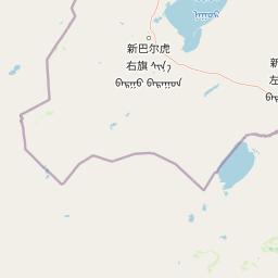
Map view of Buir Lake

Use this park location map to pinpoint Buir Lake in Mongolia, understand its exact geographic position, and read its mapped placement within the surrounding landscape more clearly.

Pigeon | © OpenStreetMap contributors

Location context for Buir Lake

Dornod Province
Park atlas

Compare connected protected areas and regional park geography across the continental interior.

Parks Near Buir Lake: Explore Regional Protected Areas and Steppe Landscapes

Browse national parks and protected areas near Buir Lake to examine shared steppe wetlands and continental basin terrain. Continued exploration of adjacent regional reserves reveals broader ecological patterns across the border region.
A watercolor painting showing a winding river flowing through a soft green landscape with grassy banks under a white sky.
National parkDornod Province
About 174 km away#1 closest

Southeast

Numrug National Park: Mapping the Transitional Geography of Eastern Mongolia

Protected river valleys and forest foothills in Dornod Province

Spanning the easternmost edge of Mongolia, Numrug National Park showcases a layered landscape where mountainous woodland merges with open grassland. The park's hydrological character, defined by the Degee and Khalkh rivers, creates a complex network of riparian habitat that serves as a vital ecological boundary within the broader Dornod Province terrain.

Established
1992
Relief
Mountain
Water
Major water bodies
Nature reserveDornod Province
About 284 km away#2 closest

Northwest

Mongol Daguur Nature Reserve: Steppe and Wetland Geography in Eastern Mongolia

Protected landscape boundaries within Dornod Province

An authoritative overview of the Mongol Daguur protected area, focusing on its role as a core element of the Daurian landscape. Discover the spatial distribution of its steppe habitats, wetland systems, and mountain-grassland terrain that define this eastern Mongolian region.

Area
156 km²
Established
1998
IUCN
Ib
Relief
Lowland
Protected areaSükhbaatar Province
About 401 km away#3 closest

Southwest

Ganga Lake Protected Area: Geographic Boundaries and Wetland Ecosystems in Sükhbaatar Province

A unique saline steppe-to-desert transition zone

Ganga Lake represents a critical wetland corridor in eastern Mongolia, where saline water bodies meet vast grasslands and sand dunes. This protected area acts as a focal point for migratory birds, offering a distinct study in regional geography and terrain contrast between the arid Gobi edge and the open Mongolian steppe.

Area
2.2 km²
Established
2004
Relief
Lowland
Scope
Terrestrial
Watercolor illustration depicting layered mountains, green hills, and forested areas with purple and pink tones
National parkZabaykalsky Krai
About 458 km away#4 closest

Northwest

Alkhanay National Park: A Study of Sacred Peaks and Daurian Forest Steppe Geography

Protected mountain landscapes in Russia's Zabaykalsky Krai

Alkhanay National Park preserves a unique transitional landscape where rugged mountain terrain meets the expansive Siberian steppe. Focused on the sacred Mount Alkhanai, the area features dramatic rock landforms, pine-covered canyons, and mineral springs. This protected zone provides a deep look into the geological and ecological history of the Mogotuyskogo Range and surrounding border regions.

Area
1,382 km²
Established
1999
IUCN
II
Relief
Mountain
Watercolor painting of a river winding through a grassy plain toward distant rolling hills under a soft light.
National parkZabaykalsky Krai
About 458 km away#5 closest

Northwest

Alkhanay National Park: Protected Mountain Terrain and Volcanic Landscapes of Zabaykalsky Krai

Mapping Siberia's forest-steppe transition and sacred mountain geography

Alkhanay National Park preserves an unusual assembly of Siberian mountain taiga, volcanic geology, and Buddhist heritage sites within the Zabaykalsky Krai region. The protected territory spans mid-elevation ranges and river valleys, offering deep insights into the intersection of ecological watershed protection and spiritual land preservation in the Russian Far East.

Area
1,382.34 km²
Established
1999
IUCN
II
Visitors
30K annual
Watercolor illustration showing a mountainous landscape with green valleys and a river, rendered in soft pink and green hues
National parkKhentii Province
About 505 km away#6 closest

West

Onon-Balj National Park: A Protected River Valley in Mongolia's Khentii Province

Explore unique geography and diverse ecosystems at a steppe-forest transition.

Onon-Balj National Park safeguards a critical river valley area in Khentii Province, Mongolia, marking an important ecological transition zone between Siberian forests and the Daurian steppe. Discover the park's mapped landscape, characterized by mid-sized mountains and riparian habitats along the Onon and Balj rivers. This protected area offers insights into regional geography, biodiversity, and the unique natural heritage of northern Mongolia.

Area
4,158 km²
Established
2000
IUCN
II
Relief
Mountain
Watercolor painting of a river winding through hills with trees and vegetation
National parkZabaykalsky Krai
About 585 km away#7 closest

Northwest

Chikoy National Park: Protected National Park with Highland Landscape and River Basin Geography

Explore its protected boundaries and unique taiga-steppe transition in Zabaykalsky Krai.

Chikoy National Park, a protected area in Russia's Zabaykalsky Krai, showcases the rugged geography of the Khentei-Daur Highlands. As a national park, it preserves the upper Chikoy River basin and represents a significant ecological borderland, marking the transition from Siberian taiga to Mongolian steppe. This page facilitates a structured understanding of the park's mapped landscape, its prominent natural monument Bystrinsky Golets, and its role within the broader atlas of protected natural areas.

Area
6,665 km²
Established
2014
IUCN
II
Relief
Mountain
Wildlife reserveKhentii Province
About 685 km away#8 closest

West

Khan Khentii Strictly Protected Area: Geographic Overview and Protected Landscape Mapping

Eastern Mongolia wilderness and Khentii mountain terrain

Explore the expansive reaches of Khan Khentii Strictly Protected Area, a cornerstone of Mongolian conservation. This reserve shields intact taiga forests, river valley habitats, and the historic Burkhan Khaldun mountain from industrial activity, preserving one of the most significant mountain wilderness regions in the province of Khentii.

Area
12,270 km²
Established
1992
IUCN
Ib
Relief
Mountain

Common questions about visiting, size, designation, and location context for Buir Lake

Buir Lake FAQs for park facts, access, geography, and protected area context

Find quick answers about Buir Lake, including protected-area facts, park geography, trail and visitor context, and how the park fits into its surrounding country and regional landscape.
MoriAtlas Explorer

Continue Your Protected Areas Search Across the Global Atlas

Deepen your exploration by continuing the structured search for national parks and protected areas worldwide. Utilize the comprehensive filtering capabilities to compare different conservation landscapes and refine your understanding of global park geography. Discover more about the distribution and characteristics of protected natural areas.

Global natural geography