
Beaches
Park geography
Analyzing the terrain, coastal features, and landscape distribution of this protected area
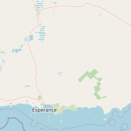
Detailed Geographic Profile and Mapped Boundaries of Cape Arid National Park, Western Australia
This geographic profile details the physical characteristics of Cape Arid National Park. The protected area spans 2794.46 square kilometers across diverse coastal and inland terrain. Key features include prominent peaks such as Mount Arid and Tower Peak, alongside extensive cliff and beach systems within this temperate Western Australia landscape.
Remote coastal wilderness on Western Australia's far south coast
Cape Arid National Park
Cape Arid National Park is a vast coastal protected area spanning approximately 2,794 square kilometres along the southern coast of Western Australia. Located about 731 kilometres southeast of Perth and 120 kilometres east of Esperance, the park encompasses a dramatic landscape of sandy beaches, rocky granite headlands, and low hills that rise northward to meet the jagged Russell Range. The park derives its name from Cape Arid, a prominent coastal feature first named by French Admiral Bruni D'Entrecasteaux in 1792 and later anglicized by Matthew Flinders in 1802. This remote park protects an ecologically significant stretch of coastline featuring the eastern end of the Recherche Archipelago, with Israelite Bay marking its eastern boundary and Duke of Orleans Bay at its western end. The park is recognized as an important bird conservation site in Western Australia, supporting over 160 bird species within its diverse coastal heath, sandplain, and woodland habitats.
- Location
- Australia
- Park type
- National park
- Established
- 1969
- Area
- 2,794.5 km²
- Highest point
- 594 m
Location overview
Mapping regional boundaries and coastal status in Western Australia
Geographic Overview of Cape Arid National Park in Western Australia
Cape Arid National Park is positioned within Western Australia, serving as a key protected area in Australia. Geographic data confirms its status as a coastal park managed within a single regional territory.
- Countries
- Australia
- Regions
- Western Australia
- Primary location
- Western Australia
- Geographic setting
- Coastal
Boundary and coordinates
Geographic footprint and regional extent covering over 2,794 square kilometers
Cape Arid National Park Boundary Map and Spatial Dimensions
Interactive geographic outlines display the spatial coverage and coastal context of Cape Arid National Park. Regional datasets detail key dimensions including estimated area, center coordinates, and spatial spans.
- Boundary area
- 2,774.6 km²
- Boundary perimeter
- 551.8 km
- Northernmost point
- 33.2845° S
- Southernmost point
- 34.0164° S
- Easternmost point
- 123.6222° E
- Westernmost point
- 122.9481° E
- Geographic centre
- 33.635° S, 123.3958° E
- North–south span
- 81.2 km
- East–west span
- 62.5 km
Elevation and terrain
Mixed relief topography and recorded natural features
Cape Arid National Park Elevation and Terrain Geography
Recorded terrain metrics outline a maximum elevation of 594 meters across mixed relief landscapes. Individual feature cards present types, measurements, and spatial relationships for named natural entities.
- Maximum elevation
- 594 m
- Highest point
- 594 m
Selected named natural features
Rivers
Thomas River
Streams
Seal Creek
Beaches
Barrier Anchorage
Viewpoints
Dolphin Cove Viewing platform
Beaches
Tagon Beach
Environmental setting
Temperate climate, coastal relief, and habitat classifications
Cape Arid National Park Environmental Setting and Classification Data
Recorded classifications frame the physical setting across coastal relief, temperate climate zones, and sparse forest cover. Linked categories connect stored environmental attributes directly to related atlas destinations.
- Relief
- Mixed relief
- Climate
- Temperate
- Water
- Major water bodies
- Forest cover
- Sparse forest
- Seasonality
- Year-round
Landscape features
Mountains · Hills · Coast · Beach · Cliffs
Habitat types
Temperate broadleaf forest · Shrubland · Heath · Grassland
Park atlas
Trace the regional spread of protected areas and compare coastal landscapes adjacent to Cape Arid National Park in Western Australia.
Explore Other National Parks and Protected Areas Near Cape Arid National Park in Western Australia
Discover other national parks and protected areas in Western Australia's coastal region, continuing your exploration beyond Cape Arid National Park. Comparing these nearby protected areas offers valuable context for understanding the broader environmental mosaic and the regional spread of conservation efforts across Australia's remote Southern Ocean coast.
National parkWestern Australia
37 km away#1 closest
West

Cape Le Grand National Park: Western Australia National Park Geographic Context and Landscape Exploration
Mapped protected area boundaries and regional natural terrain discovery.
Cape Le Grand National Park is an important national park in Western Australia, providing a distinct focus for geographic and atlas-based discovery. Understanding its protected landscape identity and its placement within the state's natural geography offers valuable insight into regional conservation areas. This page serves as a canonical entry point for exploring the mapped features and the broader geographic significance of Cape Le Grand National Park, detailed for structured atlas exploration.
- Area
- 318.01 km²
- Established
- 1966
- IUCN
- II
- Relief
- Mixed relief
Marine protected areaWestern Australia
123 km away#2 closest
West
South-west Corner Marine Park: An Atlas of Deep-Sea Landscapes and Marine Protected Areas
Western Australia offshore marine and seabed geography
South-west Corner Marine Park represents one of the most ecologically diverse marine reserves in Australian Commonwealth waters. Stretching from the coast of Western Australia into the depths of the Southern Ocean, the park protects unique underwater terrain including extensive reef systems, submarine canyons, and isolated plateaus. This area serves as a primary migratory corridor for whales and provides a vital, mapped environment for threatened shark and seabird populations within the regional marine food web.
- Area
- 271,833 km²
- Established
- 2013
- Climate
- Temperate
- Access
- Remote access
National parkWestern Australia
156 km away#3 closest
West
Stokes National Park National Park: Mapped Boundaries and Regional Geography
Western Australia's protected landscape identity.
Stokes National Park represents a significant protected entity within the expansive geography of Western Australia. This detailed page provides users with essential mapping information, focusing on the park's designated boundaries and its role within the broader atlas of Australian conservation landscapes. Explore the specific geographic context that defines this national park and understand its natural landscape features.
- Area
- 97.26 km²
- Established
- 1976
- IUCN
- II
- Relief
- Lowland
National parkWestern Australia
184 km away#4 closest
West
Peak Charles National Park: A National Park in Western Australia's Mapped Landscape
Discover its protected area status and geographic setting.
Peak Charles National Park is a vital component of Western Australia's protected natural areas. This dedicated page provides an atlas-centric view, focusing on the park's geographic scope, its mapped boundaries, and the surrounding regional landscape context. It serves as an essential resource for understanding the park's protected land identity and its contribution to the broader geography of Western Australia.
- Area
- 399.59 km²
- Established
- 1979
- IUCN
- II
- Relief
- Mountain
National parkWestern Australia
243 km away#5 closest
West
Frank Hann National Park: Explore Its Protected Area Geography and Mapped Boundaries
Western Australia's protected national park landscape.
Frank Hann National Park is a designated national park providing crucial insight into Western Australia's protected natural landscapes. This entry focuses on its precise geographic scope and mapped boundaries, allowing for detailed atlas-based exploration. Understand the park's identity as a protected area and its position within the broader regional geography of this large Australian state, ideal for focused landscape discovery.
- Area
- 675.5 km²
- Established
- 1970
- IUCN
- II
- Relief
- Lowland
National parkWestern Australia
265 km away#6 closest
West
Fitzgerald River National Park: A Western Australian Protected Landscape of Global Botanical Importance
Discover its mapped terrain, endemic flora, and UNESCO Biosphere Reserve status.
Fitzgerald River National Park stands as a protected landscape of immense ecological value in Western Australia. This national park is celebrated for its extraordinary botanical diversity, featuring more endemic plant species than any other conservation reserve in Australia. Its varied terrain, from rugged mountain ranges to coastal cliffs, provides a rich tapestry of natural habitats. As a designated UNESCO Biosphere Reserve, it offers a unique opportunity to explore mapped geographic features and understand the critical role of protected areas in conserving rare flora and distinct Mediterranean ecosystems.
- Area
- 2,972.11 km²
- Established
- 1973
- IUCN
- II
- Visitors
- 40K annual
Marine protected areaWestern Australia
269 km away#7 closest
West
Bremer Marine Park: An Offshore Atlas of Western Australia's Protected Marine Geography
Submarine canyon mapping and regional marine environment
Bremer Marine Park protects a vast, complex submarine landscape off the south coast of Western Australia. Dominated by the deep Bremer Canyon system, this protected area serves as a primary hub for studying deep sea geomorphology, coral gardens, and the nutrient-rich upwelling processes that define this unique section of the Southern Ocean.
- Area
- 4,472 km²
- Established
- 2013
- IUCN
- II
- Relief
- Mixed relief
National parkGoldfields-Esperance
320 km away#8 closest
Northwest
Goldfields Woodlands National Park: Explore Protected Area Geography and Mapped Boundaries
Discover the mapped landscape context of this national park.
Delve into Goldfields Woodlands National Park, a key protected area within the Goldfields-Esperance region. This resource provides detailed atlas-style information, focusing on the park's mapped geography, its protected status, and its role within the broader regional landscape. Understand its specific topographic features and its place in the natural atlas.
- Area
- 646.28 km²
- Established
- 2000
- Climate
- Arid
- Scope
- Terrestrial
MoriAtlas Explorer
Continue Exploring Cape Arid National Park's Geographic and Landscape Features
Delve deeper into the mapped geography and protected landscape of Cape Arid National Park. Understanding its position within Western Australia's regional context, from its dramatic coastlines to its ancient ranges, provides essential insight for anyone exploring Australia's protected areas and natural terrains through a geographic atlas. This destination offers a rich foundation for comprehending the interplay of protected lands and natural landscapes.
Browse next
Global natural geography
Explore related park routes
Explore MoriAtlas Global ParksBrowse All MoriAtlas ParksGlobal Park Map DiscoveryMoriAtlas: Browse All CountriesBrowse All MoriAtlas ContinentsNational Park Environment AtlasGrand Canyon National Park AtlasYellowstone National Park AtlasYosemite National Park Atlas and GeographySerengeti National Park AtlasGalápagos National Park Protected LandscapeBanff National Park Geography and AtlasKruger National Park Atlas EntryUluṟu-Kata Tjuṯa National Park AtlasExplore Uluru-Kata Tjuta National Park GeographyPlitvice Lakes National Park AtlasFiordland National Park Protected LandscapeGreat Smoky Mountains National Park AtlasAfghanistan National Parks and Protected AreasAlbania National Parks and Protected AreasAlgeria National Parks and Protected AreasAmerican Samoa National Parks and Protected AreasAndorra National Parks and Protected AreasAngola National Parks and Protected AreasAntarctica National Parks and Protected AreasAntigua and Barbuda Park List