
Bays
Park geography
A detailed examination of coastal land distribution, terrain data, and spatial footprint
Geographic Profile and Mapped Boundaries of Cape Blanche Conservation Park in South Australia
Analyze the spatial characteristics and environmental positioning of Cape Blanche Conservation Park on the Eyre Peninsula of South Australia. This technical profile examines the total recorded area of 810 square kilometers and its relationship with the coastal landscapes of the Great Australian Bight, providing a comprehensive look at the regional geography of this protected area.
Related tags
coastal reserveeyre peninsulasouth australiaraptor breeding habitatshorebird habitat
A coastal South Australian reserve protecting osprey, sea-eagle, and shorebird habitat on the Eyre Peninsula.
Cape Blanche Conservation Park
Cape Blanche Conservation Park is a protected area on the remote western coast of the Eyre Peninsula in South Australia, roughly 25 kilometres south of the township of Streaky Bay. Established in 2012 under the state's National Parks and Wildlife Act, the park was created specifically to safeguard coastal habitat that supports breeding populations of large fish-eating raptors and to preserve a suite of shoreline environments used by threatened and migratory shorebirds. The reserve is a large, predominantly coastal and near-shore parcel of land, classified internationally as an IUCN Category III protected area, recognising its value as a natural feature or monument of conservation significance. Its proclamation reflected concern for declining raptor breeding habitat along the Eyre Peninsula coastline and for the broader ecological value of the region's littoral vegetation, dunes, and shoreline habitats. Today the park is managed by the South Australian Department for Environment and Water and stands as one of several conservation reserves that together protect the wild, sparsely settled western edge of the peninsula. Its identity is defined less by dramatic scenery than by its quiet ecological function: maintaining a stretch of South Australian coastline where raptors can nest, where native coastal flora persists, and where migratory birds continue to find refuge.
- Location
- Australia
- Park type
- Protected area
- Established
- 2012
- Area
- 810 km²
Location overview
National and regional territory memberships across Australia and South Australia
Cape Blanche Conservation Park Regional Geography and Protected Setting
Recorded memberships place Cape Blanche Conservation Park within Australia, South Australia, and Eyre Peninsula. Administrative records confirm its coastal protected status within the regional geographic framework.
- Countries
- Australia
- Regions
- Eyre Peninsula, South Australia
- Primary location
- South Australia
- Geographic setting
- Coastal
Boundary and coordinates
Interactive boundary geometry and derived area measurements
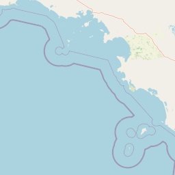
Cape Blanche Conservation Park Boundary Map and Spatial Extent
Mapped park outlines provide precise spatial context for the protected landscape across digital geography layers. Accompanying facts outline regional area measurements, coordinate limits, and geographic spans without claiming legal survey precision.
- Boundary area
- 8.3 km²
- Boundary perimeter
- 27.4 km
- Northernmost point
- 33.0092° S
- Southernmost point
- 33.0482° S
- Easternmost point
- 134.1887° E
- Westernmost point
- 134.1418° E
- Geographic centre
- 33.0275° S, 134.1677° E
- North–south span
- 4.3 km
- East–west span
- 4.4 km
Terrain and natural features
Protected landscape topography and recorded coastal feature mappings
Cape Blanche Conservation Park Terrain and Named Natural Features Explorer
Recorded natural features include the Great Australian Bight located within the protected area boundaries. Linked feature cards supply specific types, measurements, and verified spatial relationships.
Selected named natural features
Environmental setting
Analysis of recorded coastal landscape features and minor water presence
Cape Blanche Conservation Park Environmental Classifications and Physical Setting
Recorded classifications frame the physical setting through coastal landscape attributes and minor water presence. Structured categories connect recorded properties to relevant atlas destinations.
- Water
- Minor water
Landscape features
Coast
Habitat types
Coastal habitat
Park atlas
Compare regional protected areas and connected coastal landscapes across South Australia.
Explore Other Parks Near Cape Blanche Conservation Park and Surrounding Coastal Reserves
Continue browsing adjacent protected areas and shoreline reserves located throughout the wider Eyre Peninsula region. Comparing these nearby coastal habitats provides broader regional context for South Australian conservation landscapes.
Nature reserveSouth Australia
About 15 km away#1 closest
East

Calpatanna Waterhole Conservation Park: Protected Geography and Coastal Reserve Mapping
Nature reserve landscape within the South Australian Eyre Peninsula
Calpatanna Waterhole Conservation Park represents a specialized protected environment within South Australia. Centred on its namesake waterhole, the area preserves a distinctive mosaic of seasonal saline lagoons and hardy mallee eucalyptus scrub. This reserve highlights the ecological and geographic character of the Eyre Peninsula, where low undulating terrain supports unique, salt-adapted vegetation communities.
- Area
- 36.44 km²
- Established
- 1974
- IUCN
- Ia
- Relief
- Lowland
Nature reserveSouth Australia
38 km away#2 closest
North
Eba Island Conservation Park: Coastal Landforms and Nature Reserve Geography in South Australia
A protected offshore sanctuary within Streaky Bay's coastal landscape.
Eba Island Conservation Park represents a key protected area within the coastal geography of South Australia. Composed primarily of calcarenite and limestone, the reserve features a diverse range of coastal landforms, including rugged jagged ridges, active blowholes, and sheltered coves, providing an essential habitat for seabird colonies.
- Area
- 1.34 km²
- Established
- 1966
- IUCN
- Ia
- Relief
- Lowland
Wildlife reserveSouth Australia
89 km away#3 closest
Northeast
Gawler Ranges Conservation Park: Mallee Landscapes and Regional Protected Areas
Semi-arid habitat and rocky terrain of South Australia
Gawler Ranges Conservation Park protects a core area of tree mallee woodland and rocky rises near the southern fringe of the Gawler Ranges. This wildlife reserve serves as an essential anchor for regional biodiversity on the Eyre Peninsula, offering a look at the arid-adapted vegetation and weathered geological structures that define this remote section of South Australia.
- Area
- 154.8 km²
- Established
- 1993
- IUCN
- VI
- Relief
- Upland
Wildlife reserveSouth Australia
About 102 km away#4 closest
East
Cocata Conservation Park: Eyre Peninsula Protected Wildlife Reserve and Landscape Map
Geographic overview of South Australian conservation lands.
Cocata Conservation Park encompasses a vast semi-arid expanse on the Eyre Peninsula, characterized by gently undulating plains, calcrete-capped terrain, and open salt flats. Gain insights into the physical geography and habitat distribution of this important South Australian wildlife reserve through detailed regional mapping.
- Area
- 167.62 km²
- Established
- 1993
- IUCN
- VI
- Scope
- Terrestrial
National parkSouth Australia
105 km away#5 closest
Northeast
Gawler Ranges National Park: South Australia's Mapped Protected National Landscape
Explore the geography and protected area context of this national park.
Gawler Ranges National Park stands as a significant protected area within the geographic expanse of South Australia. Designated as a national park, it offers valuable insights into Australia's conservation landscapes and regional geography. Users can explore its mapped boundaries and understand its unique role within the national park system, making it a key point for structured geographic study and atlas-based discovery of protected lands.
- Area
- 1,628.75 km²
- Established
- 2002
- IUCN
- VI
- Relief
- Mountain
Wildlife reserveSouth Australia
About 114 km away#6 closest
East
Dakalanta Sanctuary: A Private Wildlife Reserve on the Northern Eyre Peninsula
Mapped regional geography and conservation habitat profiles
Dakalanta Sanctuary provides a significant example of private land conservation in South Australia. Covering 130 square kilometres of low hills and stabilized dunes, this reserve focuses on restoring native vegetation after past pastoral use. The area is vital for safeguarding semi-arid habitats like mallee woodlands, playing an active role in regional biodiversity protection and habitat connectivity.
- Area
- 130 km²
- Established
- 2002
- Relief
- Upland
- Access
- Access unknown
Marine protected areaSouth Australia
About 131 km away#7 closest
South
Western Eyre Marine Park: Geography and Marine Protected Area Atlas of South Australia
Explore offshore continental shelf zones and vast ocean boundaries
Western Eyre Marine Park represents a major commitment to marine conservation in the Great Australian Bight. This detailed atlas entry outlines the park's expansive management zones and its role within the broader South-West Marine Park Network. Observe the offshore terrain of the southern Australian continental shelf and the structural importance of this remote, cool-water oceanic reserve.
- Area
- 57,946 km²
- Established
- 2012
- Relief
- Lowland
- Climate
- Temperate
Nature reserveSouth Australia
About 132 km away#8 closest
Southeast
Cap Island Conservation Park: Nature Reserve and Offshore Marine Habitat in South Australia
Coastal granite island and protected seabird breeding landscape.
Situated off the coast of the Eyre Peninsula, Cap Island Conservation Park is a protected nature reserve serving as a critical sanctuary for pinnipeds and nesting seabirds. Its unique geological profile, featuring a granite base and calcarenite cap, creates a rugged offshore environment shaped by marine erosion and salt-tolerant vegetation. The reserve highlights the significance of isolated island ecosystems within the broader geography of South Australia.
- Area
- 0.09 km²
- Established
- 1967
- IUCN
- Ia
- Relief
- Lowland
MoriAtlas Explorer
Explore the Geographic Boundaries of Cape Blanche Conservation Park
Examine the protected shoreline and mapped coastal habitats of this Eyre Peninsula conservation site. Through the MoriAtlas database, view the landscape features and ecological significance that define this protected area within the South Australian coastal network.
Browse next
Global natural geography
Explore related park routes
Explore MoriAtlas Global ParksBrowse All MoriAtlas ParksGlobal Park Map DiscoveryMoriAtlas: Browse All CountriesBrowse All MoriAtlas ContinentsNational Park Environment AtlasGrand Canyon National Park AtlasYellowstone National Park AtlasYosemite National Park Atlas and GeographySerengeti National Park AtlasGalápagos National Park Protected LandscapeBanff National Park Geography and AtlasKruger National Park Atlas EntryUluṟu-Kata Tjuṯa National Park AtlasExplore Uluru-Kata Tjuta National Park GeographyPlitvice Lakes National Park AtlasFiordland National Park Protected LandscapeGreat Smoky Mountains National Park AtlasAfghanistan National Parks and Protected AreasAlbania National Parks and Protected AreasAlgeria National Parks and Protected AreasAmerican Samoa National Parks and Protected AreasAndorra National Parks and Protected AreasAngola National Parks and Protected AreasAntarctica National Parks and Protected AreasAntigua and Barbuda Park List