
Mori Atlas logo
Protected landscapeCape Hatteras National Seashore

A seventy-mile protected seascape of shifting dunes, maritime history, and coastal terrain.

Cape Hatteras National Seashore: Mapping the Dynamic Barrier Islands of North Carolina

Cape Hatteras National Seashore preserves a vital chain of barrier islands spanning Bodie, Hatteras, and Ocracoke in North Carolina. This protected landscape represents an expansive coastal corridor shaped by Atlantic winds, tides, and continuous geological processes. Discover the geographic reach of this historic seashore, characterized by its iconic lighthouses, estuarine shorelines, and diverse habitats for migratory waterfowl and nesting sea turtles.

barrier islandscoastal seashoreOuter BanksAtlantic coastbeachdunes
An artistic vector-style illustration of a landscape with a striped lighthouse in the center; a waterfall flows down a cliff on the right, with a sandy beach and water in the foreground and a sun setting behind pastel clouds.

Cape Hatteras National Seashore

Protected landscape

Park overview

Structured park overview, official facts, and landscape profile for Cape Hatteras National Seashore

Cape Hatteras National Seashore park facts, protected area profile, and essential visitor context

Review the core facts for Cape Hatteras National Seashore, including designation, size, terrain, visitor scale, habitats, and operating context in one park-focused overview.

About Cape Hatteras National Seashore

Cape Hatteras National Seashore represents a landmark moment in American conservation history as the country's first national seashore. Stretching across approximately 70 miles of the Outer Banks, the park protects a near-continuous ribbon of barrier islands, sandy beaches, dunes, maritime forests, and salt marshes from Bodie Island in the north to Ocracoke Island in the south. The seashore sits within a complex coastal system shaped by wind, waves, and shifting sands, and it preserves some of the most dynamic natural shoreline on the U.S. East Coast.

The park is far more than a recreational beach destination. It safeguards an essential stretch of Atlantic coastline that serves as a wintering ground for migratory waterfowl and as nesting habitat for several species of shorebirds and sea turtles. The islands host a mosaic of habitats, from open sandy beaches and rolling dunes to sheltered maritime forests and coastal wetlands. Rodanthe, on Hatteras Island, is particularly notable for its high rates of beach erosion, illustrating how actively these barrier islands are reshaped by the sea.

Culturally, Cape Hatteras carries a powerful maritime identity. The waters off the cape have claimed thousands of vessels over the centuries, earning the area its somber nickname. The park preserves remnants of this history through its lighthouses, keeper's quarters museums, and interpretive programs. Today, Cape Hatteras also balances its protected natural values with long-standing traditions of recreation, surf fishing, and off-road vehicle use, making it a unique example of a working, lived-in coastal preserve.

Quick facts and research context for Cape Hatteras National Seashore

Cape Hatteras National Seashore is located on the Outer Banks of North Carolina, spanning parts of Dare County and Hyde County. Established on January 12, 1953, it was the first national seashore designated in the United States and is administered by the National Park Service alongside Wright Brothers National Memorial and Fort Raleigh National Historic Site.

The seashore stretches roughly 70 miles along a chain of barrier islands and is classified by the IUCN as a protected landscape/seascape. The region has a humid subtropical climate, is highly exposed to Atlantic hurricanes and nor'easters, and is considered a critical wintering area for migratory waterfowl as well as important nesting habitat for shorebirds and sea turtles.

Protection and recognition

Evaluated protection scope and official international designation records

Cape Hatteras National Seashore Protection Status and Conservation Recognition

Comprehensive protected area records outline the mixed management scope and administrative framework established for Cape Hatteras National Seashore. Official conservation data compiles verified status indicators and international recognition metrics into a single reference.

Protection details

Protection scope
Mixed
Transboundary protection
No
Park context

Deeper park guide and search-rich context for Cape Hatteras National Seashore

Cape Hatteras National Seashore history, landscape, wildlife, and travel context

Explore Cape Hatteras National Seashore through its history, landscape character, ecosystems, wildlife, conservation priorities, cultural context, and seasonal travel timing in a structured park guide built for atlas discovery and search intent.

Why Cape Hatteras National Seashore stands out

Cape Hatteras National Seashore is best known for the Graveyard of the Atlantic, a stretch of coast steeped in maritime history, dramatic shipwrecks, and storied lifesaving operations. The park is also renowned for its iconic lighthouse, Cape Hatteras Light, which was famously relocated inland in 1999 to save it from shoreline erosion. Beyond its history, the park is celebrated for its outstanding recreational beaches, consistently ranked among the best surfing and fishing spots on the U.S. East Coast. The barrier islands within the seashore support vital habitats for migrating waterfowl, nesting shorebirds, and sea turtles, making it both a recreational destination and an ecologically significant coastline.
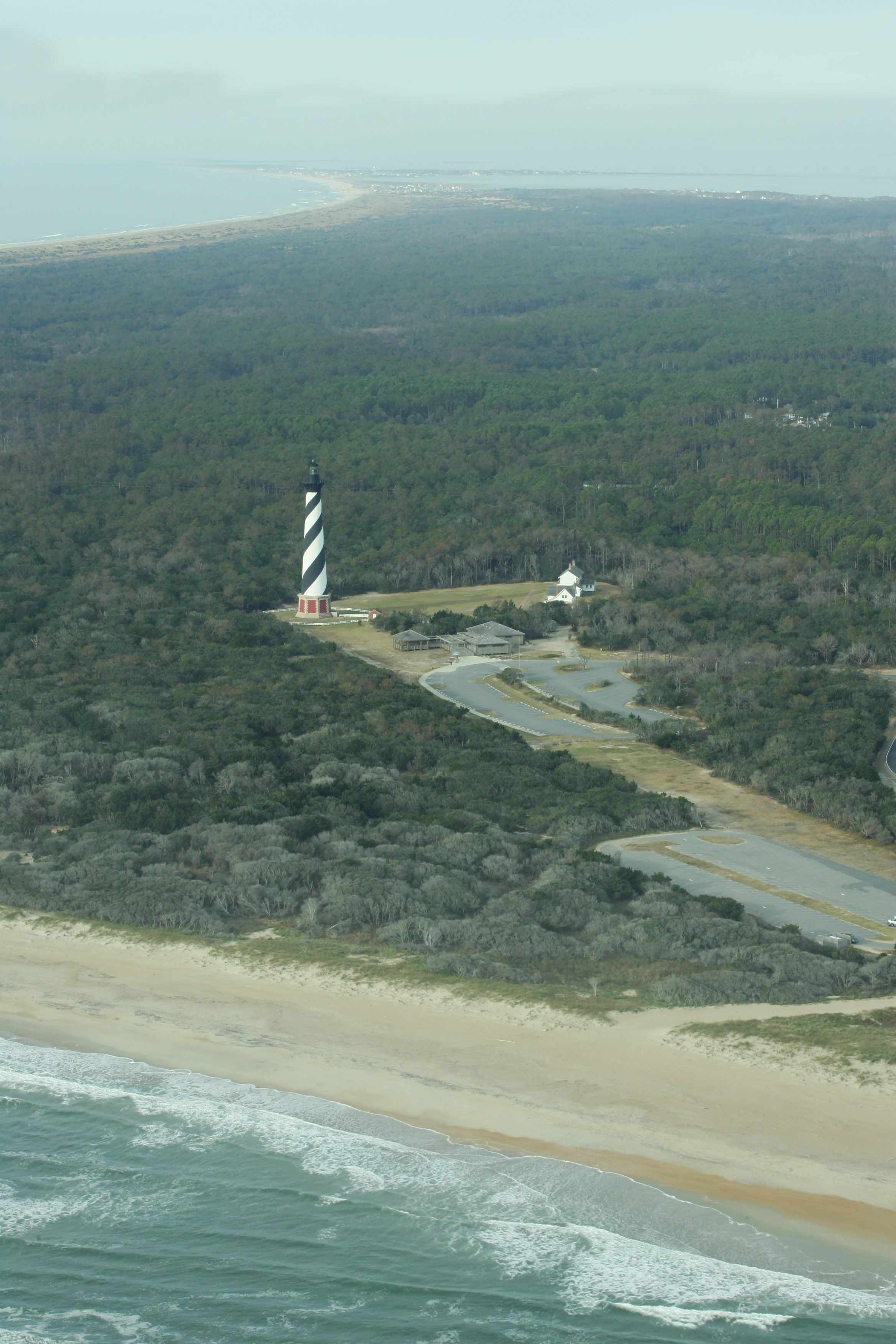
An aerial photograph showing the striped Cape Hatteras Lighthouse situated amidst dense maritime forest with a sandy coastline and the Atlantic Ocean in the foreground.
An aerial view of the iconic black and white spiral-striped Cape Hatteras Lighthouse surrounded by coastal forest and sandy beaches.

Cape Hatteras National Seashore history and protected-area timeline

Cape Hatteras National Seashore was first authorized by the U.S. Congress on August 17, 1937, after years of growing concern about preserving the fragile Outer Banks coastline. A substantial portion of the land required to establish the park was donated by philanthropist Paul Mellon, whose contribution was instrumental in bringing the seashore into being.

In 1940, Congress renamed the park Cape Hatteras National Seashore Recreational Area to accommodate hunting interests, a notable concession in a National Park Service managed unit at the time. The seashore was officially established as the first national seashore in the United States on January 12, 1953, and was formally dedicated on April 24, 1958. Since then, it has been co-managed with two nearby Outer Banks parks, Wright Brothers National Memorial in Kill Devil Hills and Fort Raleigh National Historic Site on Roanoke Island.

The park's history also includes one of its most iconic structural events: the relocation of the Cape Hatteras Lighthouse. In 1999, the 4,830-ton lighthouse was painstakingly moved nearly 2,900 feet inland to save it from being overtaken by the eroding shoreline. Cape Hatteras has also been a focal point of modern conservation debates, particularly regarding off-road vehicle access and the protection of nesting shorebirds and sea turtles, leading to new ORV management plans adopted in 2012.

Cape Hatteras National Seashore landscape and geographic character

The landscape of Cape Hatteras National Seashore is defined by the long, narrow chain of barrier islands that make up North Carolina's Outer Banks. These islands are composed largely of sandy beaches, shifting dunes, and low-lying terrain shaped continuously by Atlantic winds, tides, and storms. The protected coastline runs more than 70 miles, creating an almost uninterrupted ribbon of ocean beach, sound-side estuarine shoreline, and sandy interior scrub.

Barrier islands themselves are the defining landform here. These dynamic strips of sand are naturally reshaped by currents and storm events, sometimes at dramatic rates; Rodanthe, in particular, has experienced one of the highest rates of beach erosion along the Outer Banks. Inland from the beaches, low dunes give way to maritime shrub thickets and pockets of salt-tolerant vegetation, while the western shores face the calmer waters of Pamlico Sound.

The park's dramatic seascapes include towering lighthouses perched along the ocean's edge, rolling surf, and wide open horizons where the Atlantic meets the sky. The terrain, while low in elevation overall, feels expansive and exposed, offering some of the most recognizable coastal scenery in the eastern United States.
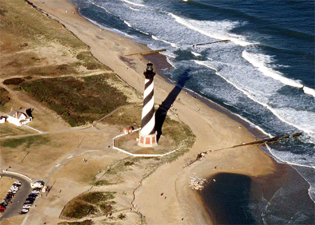
An aerial shot of the Cape Hatteras Lighthouse standing on a sandy beach beside the Atlantic Ocean, with a parking area visible on the lower left.
Aerial view of the iconic black-and-white spiraled Cape Hatteras Lighthouse situated along the barrier island coastline.

Cape Hatteras National Seashore ecosystems, habitats, and plant life

Cape Hatteras National Seashore encompasses a varied coastal ecosystem typical of the Outer Banks barrier island system. Beach and dune environments dominate the ocean side, while the sound side features salt marshes, estuarine shallows, and brackish wetlands. These shifting habitats together support a complex coastal food web.

Potential natural vegetation in the area is characterized by live oak and sea oats along coastal prairie formations, illustrating the blend of woodland and open sandy landscapes that historically defined the islands. In reality, the protected landscape is shaped heavily by wind, salt spray, and human activity, which has produced a mosaic of hardy coastal vegetation rather than dense forest.

The park's natural value lies largely in its ecological function rather than its species richness alone. The barrier islands and associated wetlands provide essential stopover, wintering, and breeding habitat for a wide range of wildlife, including migratory waterfowl, shorebirds, and sea turtles. The dynamic nature of the islands, while challenging for permanent vegetation, creates constantly evolving habitat pockets that are critical to the broader Atlantic Flyway ecosystem.

Cape Hatteras National Seashore wildlife and species highlights

Cape Hatteras National Seashore is widely recognized for its importance as a wintering area for migratory waterfowl and as nesting habitat for multiple species of shorebirds and sea turtles. The combination of open sandy beaches, dunes, and protected sound-side estuarine habitats supports a rich seasonal cycle of birdlife along the Atlantic Flyway.

The park's beaches provide critical nesting grounds for threatened and federally protected shorebird species, as well as for sea turtles that return seasonally to lay their eggs in the sand. Nesting activities draw significant conservation attention, and portions of the beach are routinely closed during nesting seasons to protect vulnerable colonies.

While large mammals are not central to the park's identity, the surrounding marine environment supports important recreational fisheries, and the sound-side waters host crabs, shrimp, and a variety of estuarine fish. The wildlife character of Cape Hatteras is defined more by seasonal migrations, nesting colonies, and coastal adaptation than by resident charismatic megafauna.

Cape Hatteras National Seashore conservation status and protection priorities

Cape Hatteras National Seashore plays an important conservation role by protecting a continuous 70-mile stretch of the Outer Banks, one of the most ecologically significant barrier island systems on the U.S. Atlantic coast. Its beaches and dunes serve as nesting habitat for several federally protected shorebird and sea turtle species, while its estuarine and sound-side environments support migratory waterfowl populations that depend on the Atlantic Flyway.

Conservation management at Cape Hatteras has increasingly focused on balancing public recreation with habitat protection. Concerns over the impacts of off-road vehicle use on nesting wildlife led to legal action and, ultimately, a revised ORV management plan adopted in January 2012. Under this plan, portions of the beach are designated as year-round vehicle-free zones or seasonally restricted areas to safeguard nesting birds and turtles.

The park also illustrates the broader conservation challenge of preserving barrier islands in a shifting climate. With extremely high erosion rates in places like Rodanthe and ongoing exposure to hurricanes and nor'easters, Cape Hatteras stands as a working example of how protected area management must adapt to dynamic coastal processes, including the dramatic 1999 relocation of the Cape Hatteras Light itself.

Cape Hatteras National Seashore cultural meaning and human context

Cape Hatteras carries a powerful cultural identity shaped by centuries of maritime activity, shipwrecks, and lifesaving efforts. The waters off Cape Hatteras are famously known as the Graveyard of the Atlantic, a name earned through countless vessels lost to shifting shoals, sudden storms, and treacherous currents over the centuries. This seafaring legacy is preserved through the park's lighthouses, museum exhibits, and historic lifesaving stations.

The barrier islands also retain a distinctive local culture. Small fishing communities such as Buxton, Rodanthe, and Ocracoke coexist alongside and within the park boundaries, sustaining traditions of surf fishing, small-scale maritime work, and island living. The historical practice of off-road vehicle use on the beaches has become part of regional identity and a recurring point of cultural intersection with modern conservation policy.

Together, these layers of maritime, lifesaving, and community heritage give Cape Hatteras National Seashore a cultural depth that reflects both the dangers of the Atlantic and the resilience of the people who have lived along its shifting shores.

Top sights and standout views in Cape Hatteras National Seashore

The park's first national seashore designation in the United States and its 70-mile span of Outer Banks coastline form the foundation of its identity. Iconic structures such as Cape Hatteras Light, moved inland in 1999, and the historic Bodie Island and Ocracoke lighthouses anchor the park's maritime story and serve as recognizable visitor landmarks.

Equally important are the park's ecological highlights: critical nesting beaches for sea turtles and shorebirds, vital wintering habitat for migratory waterfowl, and dynamic barrier island landscapes that illustrate coastal processes in action. World-class surf fishing and surfing, combined with access to remote beaches and sound-side waterscapes, round out a park experience that blends natural beauty, recreation, and history in one continuous stretch of coast.

Best time to visit Cape Hatteras National Seashore

Cape Hatteras National Seashore has a humid subtropical climate with mild winters and warm, humid summers moderated by cooling sea breezes. Spring and fall are often considered the most comfortable times to visit, when temperatures are moderate, humidity is lower, and wildlife activity, including migratory bird movements and nesting shorebird activity, is at its peak.

Summer offers warm ocean water and long days ideal for swimming, surfing, and family beach use, though it also brings increased humidity and the early months of the Atlantic hurricane season from June through November. Winter is mild compared to most of the U.S. East Coast and can be a rewarding time for quiet beaches, birdwatching, and dramatic seascapes shaped by nor'easters and shifting winter storms.
Monthly climate preview

Long term representative measurements tracking monthly temperature and precipitation patterns

Cape Hatteras National Seashore Climate Normals and Annual Temperature Rhythm

Representative coordinate records show average monthly temperatures ranging from 10.52 degrees Celsius to 26.73 degrees Celsius alongside recorded daily precipitation rates. Detailed monthly climate normals provide complete statistical context for analyzing long term environmental rhythms across the protected area.
Annual mean18 °C
11 °C27 °C
Jan11°
Feb11°
Mar13°
Apr16°
May20°
Jun25°
Jul27°
Aug26°
Sep24°
Oct20°
Nov16°
Dec13°
Warmest month
July

26.7 °C

Coolest month
January

10.5 °C

Wettest month
August

5.5 mm/day

Driest month
April

3.1 mm/day

Park location guide

Geography guide, regional context, and park location map for Cape Hatteras National Seashore

Cape Hatteras National Seashore park geography, regions, and map view in United States of America

Understand where Cape Hatteras National Seashore sits in United States of America through a broader geographic reading of the surrounding landscape, nearby location context, and its mapped position within the national park landscape.

How Cape Hatteras National Seashore fits into United States of America

The United States of America is a federal presidential republic and one of the world's largest countries by area and population. It consists of 50 states across a vast territory spanning multiple time zones, with its capital in Washington, D.C. and largest city in New York City. The nation has a diverse economy, influential political system, and significant cultural and military presence globally.

Wider geography shaping Cape Hatteras National Seashore in United States of America

The United States occupies a vast territory in North America, bordered by Canada to the north and Mexico to the south. The 48 contiguous states stretch from the Atlantic to the Pacific Ocean, while Alaska occupies the northwestern region and Hawaii is an archipelago in the Pacific. The country encompasses diverse terrain including the Rocky Mountains, Appalachian Mountains, Great Plains, and extensive river systems.

Map view of Cape Hatteras National Seashore

Use this park location map to pinpoint Cape Hatteras National Seashore in United States of America, understand its exact geographic position, and read its mapped placement within the surrounding landscape more clearly.

Pigeon | © OpenStreetMap contributors

Location context for Cape Hatteras National Seashore

North Carolina

Visualizing barrier island terrain, coastal scenery, and protected habitats

Cape Hatteras National Seashore Photos and Landscapes

Examine professional photography and detailed visual records documenting the shifting dunes, sandy beaches, and maritime environments of Cape Hatteras National Seashore. Visualizing these protected coastal landscapes reveals the distinct geography, dynamic terrain, and natural character of the Outer Banks.

An aerial photograph showing the striped Cape Hatteras Lighthouse situated amidst dense maritime forest with a sandy coastline and the Atlantic Ocean in the foreground.

A brown rectangular park entrance sign for Cape Hatteras National Seashore featuring the National Park Service arrowhead logo and an icon of a striped lighthouse.

An aerial shot of the Cape Hatteras Lighthouse standing on a sandy beach beside the Atlantic Ocean, with a parking area visible on the lower left.

Park atlas

Compare regional barrier islands, coastal seashores, and nearby protected landscapes

Parks Near Cape Hatteras National Seashore and Other Protected Areas

Browse nearby national parks and protected areas located throughout the surrounding region to compare coastal barrier island ecosystems. Expanding the search helps connect maritime reserves and dynamic coastal landscapes into a broader geographic framework.
A watercolor painting showing a wide, panoramic view of a sandy coastal landscape with rolling dunes, sparse green vegetation, and a winding shoreline under a pale sky.
Protected landscapeNorth Carolina
2.3 km away#1 closest

Southwest

Cape Lookout National Seashore: Atlas of a Protected North Carolina Barrier Island System

Coastal geography and protected island landscapes

Navigate the wild, roadless environment of Cape Lookout National Seashore. This protected landscape spans three major barrier islands, offering a unique look at Atlantic coastal geography, including dunes, tidal flats, and maritime grasslands that define the Crystal Coast.

Area
114.3 km²
Established
1966
IUCN
V
Visitors
541.5K annual
Marine protected areaNorth Carolina
About 27 km away#2 closest

South

Monitor National Marine Sanctuary: Map and Protected Area Geographic Context

Underwater heritage site in North Carolina Atlantic waters

Monitor National Marine Sanctuary stands as a landmark of marine conservation, designated specifically to preserve the remains of the USS Monitor ironclad warship. Located off Cape Hatteras, the sanctuary provides a defined underwater landscape where historical research, archaeology, and natural reef formation converge. Discover the spatial context of this significant Atlantic protected area and its enduring legacy in American naval history.

Area
2.69 km²
Established
1975
Relief
Lowland
Climate
Subtropical
Nature reserveVirginia
About 197 km away#3 closest

Northwest

Chesapeake Bay National Estuarine Research Reserve, Virginia: Coastal and Estuarine Atlas

Mapped protected landscapes of the York River estuary.

Spanning the critical salinity gradient of the York River, this nature reserve integrates diverse tidal habitats including expansive marshes, quiet creeks, and coastal islands. As a center for scientific monitoring, the reserve offers a layered view of Mid-Atlantic estuarine geography, protecting essential buffers and water channels that define the lower Chesapeake Bay region.

Established
1991
Relief
Lowland
Climate
Temperate
Access
Access unknown
A horizontal watercolor illustration depicting a grassy shoreline with a single tree and distant rolling hills against a soft pale sky.
Nature reserveNorth Carolina
About 198 km away#4 closest

Southwest

North Carolina National Estuarine Research Reserve: Mapped Protected Coastal Terrain

Coastal habitat and biogeographic research corridor

Spanning from Currituck Banks to Zeke's Island, the North Carolina National Estuarine Research Reserve preserves a diverse coastal mosaic. This protected area supports essential estuarine functions and provides critical habitat for numerous aquatic species, defining the complex intersection of land and sea in the southeastern United States.

Area
42.76 km²
Established
1985
Relief
Lowland
Climate
Subtropical
A minimalist watercolor painting depicting a soft green and pastel landscape with rolling hills and a central pond or marshy area on a white background.
Protected landscapeMaryland
218 km away#5 closest

North

Assateague Island National Seashore: Geographic Atlas and Protected Landscape Overview

Dynamic barrier island terrain in the Maryland region

Assateague Island National Seashore preserves one of the most naturally functioning barrier island ecosystems in the Mid-Atlantic. This protected stretch of coastline showcases the interaction between sediment movement, storm-driven overwash, and salt marsh development, offering a clear view of how barrier systems respond to environmental forces.

Area
167.2 km²
Established
1965
IUCN
V
Visitors
2.3M annual
A watercolor painting showing a soft, stylized view of rolling green hills, trees, and a river flowing through a valley.
Marine protected areaCharles County
313 km away#6 closest

Northwest

Mallows Bay, Potomac River National Marine Sanctuary: Mapping the Potomac River Ghost Fleet

A historic marine protected area in Charles County, Maryland.

The Mallows Bay, Potomac River National Marine Sanctuary preserves a significant maritime archaeology site within the Chesapeake Bay watershed. The protected area features the Ghost Fleet of World War I era steamships that have been reclaimed by river ecology. This region offers a distinct look at the intersection of cultural history and tidal freshwater habitats in Southern Maryland.

Area
47 km²
Established
2019
IUCN
V
Relief
Lowland
Nature reserveDelaware
About 354 km away#7 closest

North

Delaware National Estuarine Research Reserve: Coastal Estuary and Wetland Protected Landscape

A paired nature reserve system in Delaware

Delaware National Estuarine Research Reserve preserves a significant coastal gradient across two distinct units in Kent County. From the freshwater wetlands and forests of Blackbird Creek to the tidal salt marshes of the St. Jones River, this protected area serves as a primary hub for estuarine research, monitoring aquatic conditions, and safeguarding biodiversity within the Delaware Bay ecological corridor.

Established
1937
IUCN
IV
Relief
Lowland
Climate
Temperate
Watercolor painting of rolling hills, trees, and a river in a scenic landscape
National parkVirginia
371 km away#8 closest

Northwest

Shenandoah National Park: National Park Protected Landscape and Geography

Mapped terrain and protected area context in Virginia.

Shenandoah National Park is a designated national park in Virginia, offering a rich exploration of its protected landscape and geographic features. This page provides detailed atlas-oriented information, focusing on the park's mapped boundaries and its role within the regional geography. Discover the natural terrain and spatial identity of this important US protected area, ideal for understanding park landscapes.

Area
811.176 km²
Established
1935
IUCN
II
Visitors
1.7M annual

Common questions about visiting, size, designation, and location context for Cape Hatteras National Seashore

Cape Hatteras National Seashore FAQs for park facts, access, geography, and protected area context

Find quick answers about Cape Hatteras National Seashore, including protected-area facts, park geography, trail and visitor context, and how the park fits into its surrounding country and regional landscape.
MoriAtlas Explorer

Continue Your Protected Areas Search Across the Global Atlas

Deepen your exploration by continuing the structured search for national parks and protected areas worldwide. Utilize the comprehensive filtering capabilities to compare different conservation landscapes and refine your understanding of global park geography. Discover more about the distribution and characteristics of protected natural areas.

Global natural geography