

Mori Atlas logo
Marine protected areaCape Howe Marine National Park

Map and geographic context for a marine protected area where Victoria meets New South Wales.

Cape Howe Marine National Park: Victoria's Protected Marine Landscape at the Southern Ocean Coast

Cape Howe Marine National Park represents a significant protected marine area situated at the southeasternmost tip of Victoria, Australia. This 4,050-hectare marine park, stretching between Gabo Island and Cape Howe, shields a dramatic stretch of coastline characterized by exposed waters, rocky headlands, and the powerful influence of the Southern Ocean. Established in November 2002, it forms a vital part of Victoria's marine protected area network, offering a glimpse into coastal wilderness and marine ecosystems shaped by powerful oceanic forces. The park's adjacency to terrestrial protected lands creates a continuous conservation landscape along the eastern Victorian shore.

marine protected areaVictoria national parkSouthern Ocean coastcoastal wildernessEast Gippslandrocky coastline

Cape Howe Marine National Park

Marine protected area

Park overview

Structured park overview, official facts, and landscape profile for Cape Howe Marine National Park

Cape Howe Marine National Park park facts, protected area profile, and essential visitor context

Review the core facts for Cape Howe Marine National Park, including designation, size, terrain, visitor scale, habitats, and operating context in one park-focused overview.

About Cape Howe Marine National Park

Cape Howe Marine National Park represents one of Victoria's newer marine protected areas, established in 2002 to preserve a significant stretch of the state's eastern coastline and its associated marine ecosystems. The park occupies a geographically remote position at Victoria's far eastern tip, where the coastline turns northward toward the New South Wales border. This location places the marine park in a transitional zone between the Southern Ocean and the Tasman Sea, creating unique marine conditions influenced by both bodies of water. The park extends from the waters just east of Gabo Island, which itself is a notable wildlife sanctuary known for its seabird populations, southward to Cape Howe, the southernmost point along the Victoria-New South Wales border. This coastal corridor has historically been relatively remote and undeveloped, which has helped preserve its natural character and ecological values. The establishment of the park reflected a broader commitment by Victoria to expand its marine protected area network, recognizing that coastal and offshore waters require specific conservation attention alongside terrestrial protected areas. The park's management by Parks Victoria ensures coordinated protection with the adjacent Croajingolong National Park, allowing for integrated conservation of both the coastal marine environment and the adjoining terrestrial landscape.

Quick facts and research context for Cape Howe Marine National Park

Cape Howe Marine National Park covers approximately 4,050 hectares along Victoria's far eastern coastline. The park extends from just east of Gabo Island to Cape Howe, the southernmost point of the Victoria-New South Wales border. It is classified as an IUCN Category II protected area, reflecting its national park status. The park is managed by Parks Victoria and was officially established on 16 November 2002. The nearest population center is Mallacoota, a small coastal town in East Gippsland that serves as a gateway to this remote marine environment.

Protection and recognition

Documenting the marine protection scope, international recognition, and official boundary status

Cape Howe Marine National Park Protection Status and Conservation Designations

Marine conservation researchers can explore the documented protection scope, designation framework, and official management boundaries of Cape Howe Marine National Park. Consolidated records outline the marine-specific status and historical classification to provide reliable geographic context for global protected area tracking.

Protection details

Protection scope
Marine
Park context

Deeper park guide and search-rich context for Cape Howe Marine National Park

Cape Howe Marine National Park history, landscape, wildlife, and travel context

Explore Cape Howe Marine National Park through its history, landscape character, ecosystems, wildlife, conservation priorities, cultural context, and seasonal travel timing in a structured park guide built for atlas discovery and search intent.

Why Cape Howe Marine National Park stands out

Cape Howe Marine National Park is known for its dramatic coastal landscape where the Southern Ocean meets rugged Victorian shoreline. The park protects a stretch of coastline characterized by rocky headlands, exposed cliffs, and the powerful surf that characterizes this part of Australia's east coast. The marine environment supports diverse coastal and oceanic species within its protected boundaries, with the waters around Gabo Island and Cape Howe providing important habitat in this relatively untouched section of Victoria's coast. The park's adjacency to Croajingolong National Park creates a continuous protected landscape that spans both marine and terrestrial environments.

Cape Howe Marine National Park history and protected-area timeline

Cape Howe Marine National Park was established on 16 November 2002 as part of Victoria's marine protected area expansion program. The creation of this marine park reflected growing recognition of the ecological importance of Victoria's coastal waters and the need to provide formal protection for marine ecosystems that had previously received limited conservation attention. The park's establishment came during a period when Victoria was systematically adding marine national parks to its protected area network, following the endorsement of marine conservation strategies in the 1990s and early 2000s. The timing of the park's creation also reflected the importance of protecting this relatively unspoiled coastal region before development pressures could significantly alter its character. Parks Victoria assumed responsibility for managing the park, working in coordination with the adjacent Croajingolong National Park to ensure integrated conservation management across the marine-terrestrial boundary. The park's IUCN Category II classification reflects its status as a national park with significant conservation value, recognizing both its ecological importance and its role in providing natural experiences for visitors.

Cape Howe Marine National Park landscape and geographic character

The landscape of Cape Howe Marine National Park is defined by the dramatic meeting point between the Southern Ocean and Victoria's eastern coastline. Rocky headlands and exposed coastal cliffs characterize the shoreline, with Cape Howe itself serving as a prominent landmark where the coastline shifts direction toward the north. The marine waters within the park range from nearshore zones near the coast to more open ocean conditions further offshore, with varying depths and bottom substrates that support different marine communities. The coastline in this region is relatively untamed, with powerful surf and the persistent influence of Southern Ocean weather patterns shaping both the terrestrial and marine environments. Gabo Island, located just to the west of the park's boundaries, creates an additional landscape element that influences local ocean conditions and provides a nesting habitat for significant seabird populations. The combination of rocky shoreline, exposed headlands, and open ocean waters creates a landscape of considerable visual and ecological significance.

Cape Howe Marine National Park ecosystems, habitats, and plant life

The marine environment of Cape Howe Marine National Park supports ecosystems characteristic of Victoria's cool-temperate southern coast. The waters in this region are influenced by the Southern Ocean, which brings nutrient-rich currents that support productive marine food webs. The park's protected status helps preserve these marine communities from pressures such as commercial fishing and coastal development that have affected other parts of Victoria's coastline. The nearshore waters contain diverse habitats including rocky reef systems, sandy seafloor, and areas of mixed substrate that support various marine species. The proximity to Gabo Island, a well-known seabird nesting site, indicates the ecological importance of this coastal zone for marine birds that depend on productive waters for foraging. The adjacent Croajingolong National Park provides terrestrial ecological context, with the combination of protected land and marine areas supporting broader ecosystem processes that cross the shoreline boundary.

Cape Howe Marine National Park wildlife and species highlights

The waters and coastline of Cape Howe Marine National Park support marine wildlife characteristic of Victoria's eastern coast. The region is important for seabirds that use the coastal cliffs and offshore islands for nesting and resting, with Gabo Island nearby serving as a particularly significant colony location. The marine waters provide foraging habitat for various seabird species, as well as supporting fish and invertebrate communities that form the base of the coastal marine food web. The exposed coastal waters attract species adapted to wave-exposed conditions, while more sheltered areas near the shore support different assemblages of marine life. The cold Southern Ocean waters are productive enough to support diverse fish species and provide feeding grounds for marine mammals and seabirds that range through this section of coastline. While the Wikipedia source does not provide detailed species lists, the park's protected status helps preserve these wildlife communities and the ecological processes that sustain them.

Cape Howe Marine National Park conservation status and protection priorities

Cape Howe Marine National Park contributes to Victoria's marine conservation network by protecting a significant stretch of relatively unmodified eastern coastline and its associated marine ecosystems. The park's establishment in 2002 represented a commitment to preserving coastal marine environments that had historically received less protection than terrestrial areas. As a Category II protected area, the park is managed for both conservation and natural experience, allowing for compatible recreational use while maintaining ecological integrity. The park's adjacency to Croajingolong National Park creates ecological connectivity between marine and terrestrial protected areas, which is important for species that move between these environments and for broader ecosystem processes. The protection of this coastal zone helps preserve natural coastal processes, wildlife habitat, and the aesthetic values of Victoria's eastern shoreline. Marine national parks in Victoria are designated to protect representative examples of the state's marine environments, and Cape Howe contributes to this network by preserving a section of coastline with distinctive ecological character.

Cape Howe Marine National Park cultural meaning and human context

The coastal region around Cape Howe has historical significance for Aboriginal communities who have connections to the land and coastal waters of East Gippsland. The traditional lands of the Bidawel people and other Aboriginal groups extend along this section of Victoria's coast, with the coastline and marine environments forming part of their cultural landscape. European exploration and settlement of the East Gippsland coast occurred relatively late due to the region's remoteness and rugged character. Mallacoota and the surrounding area developed as a small coastal community with connections to fishing, timber, and more recently, nature-based tourism. The naming of Cape Howe reflects the area's colonial history, with the cape named after Admiral Earl Howe, an early British naval figure. The region's cultural heritage adds context to the landscape, though the primary focus of the park's significance lies in its natural values.

Top sights and standout views in Cape Howe Marine National Park

The standout features of Cape Howe Marine National Park include its remote location at Victoria's far eastern tip, the dramatic coastal scenery where powerful Southern Ocean swells meet rocky headlands, and the protection of marine ecosystems in a relatively unmodified coastal environment. The park's adjacency to Croajingolong National Park creates a continuous protected landscape from the inland mountains to the offshore waters. Cape Howe itself serves as a notable geographic landmark, marking both a physical turning point in the coastline and the border between Victoria and New South Wales. The marine waters around Gabo Island, one of Victoria's most famous seabird nesting sites, add ecological significance to the broader protected area. The park offers opportunities for experiencing Victoria's coastal wilderness with its exposed shores, powerful surf, and the sense of remoteness that characterizes this easternmost section of the state.

Best time to visit Cape Howe Marine National Park

The optimal time to explore Cape Howe Marine National Park depends on the type of experience sought. The summer months of December through February typically offer the most comfortable conditions for coastal activities, with warmer air temperatures and longer daylight hours. However, this is also the period when the park experiences higher visitor numbers given its popularity during the Victorian summer holiday season. The winter months bring cooler conditions but can still offer rewarding visits for those interested in the park's dramatic coastal character, with the powerful winter swells creating impressive wave action along the shoreline. Spring and autumn provide intermediate conditions with moderate temperatures and fewer visitors. The marine environment is accessible year-round, though water activities are more comfortable during the warmer months. Weather conditions along this exposed coast can change rapidly, so visitors should be prepared for variable conditions regardless of the season.
Monthly climate preview

Long term temperature averages and monthly precipitation profiles for the coastal reserve

Cape Howe Marine National Park Climate and Monthly Weather Normals

Long term data at the representative coordinate show a mild maritime climate where average temperatures peak near twenty degrees Celsius in February and fall to twelve degrees in July. Exploring the complete climate profile reveals detailed monthly highs, lows, and precipitation rhythms across the annual cycle of the reserve.
Annual mean16 °C
12 °C20 °C
Jan20°
Feb20°
Mar19°
Apr17°
May15°
Jun13°
Jul12°
Aug12°
Sep14°
Oct15°
Nov16°
Dec18°
Warmest month
February

20.1 °C

Coolest month
July

12.2 °C

Wettest month
November

3 mm/day

Driest month
August

1.8 mm/day

Park location guide

Geography guide, regional context, and park location map for Cape Howe Marine National Park

Cape Howe Marine National Park park geography, regions, and map view in Australia

Understand where Cape Howe Marine National Park sits in Australia through a broader geographic reading of the surrounding landscape, nearby location context, and its mapped position within the national park landscape.

How Cape Howe Marine National Park fits into Australia

Australia is a constitutional monarchy and federal parliamentary democracy comprising six states and ten territories. With a population of nearly 28 million, it is one of the world's most urbanised countries, with most people concentrated on the eastern seaboard. The country has a high Human Development Index and is known for its cultural diversity, ancient Aboriginal heritage, and unique wildlife.

Wider geography shaping Cape Howe Marine National Park in Australia

Australia occupies the entire Australian continent, the island of Tasmania, and numerous smaller islands. It is the world's flattest and driest inhabited continent, featuring vast deserts in the interior (the Outback), tropical rainforests along the eastern coast, and a coastline bordering the Indian and Pacific Oceans.

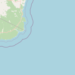
Map view of Cape Howe Marine National Park

Use this park location map to pinpoint Cape Howe Marine National Park in Australia, understand its exact geographic position, and read its mapped placement within the surrounding landscape more clearly.

Pigeon | © OpenStreetMap contributors
Natural feature types

Investigate the Natural Features of Cape Howe Marine National Park

Deepen your understanding of the park by navigating through its distinct natural landmarks and coastal geography. MoriAtlas organizes these features to help you visualize the complex terrain where the Southern Ocean meets the rugged Victorian shore.
Park atlas

Map the geographic context of Victoria's eastern coastal wilderness and its connected protected landscapes.

Compare Protected Areas and Nearby Parks Around Cape Howe Marine National Park, Victoria

Continue your exploration from Cape Howe Marine National Park by browsing adjacent marine reserves and the terrestrial national parks that form a continuous protected landscape along Victoria's remote eastern coastline. This geographic comparison provides valuable context for understanding regional conservation efforts and the diverse protected areas that define the border region between Victoria and New South Wales.
National parkAustralia
Park boundaries overlap#1 closest

Northwest

Croajingolong National Park: A UNESCO World Biosphere Reserve with Dramatic Coastal Geography

Explore Victoria's protected wilderness, mapped coastlines, and diverse ecosystems.

Croajingolong National Park is a key protected area in Victoria, Australia, recognized globally as a UNESCO World Biosphere Reserve. This vast national park offers a detailed look at coastal wilderness, characterized by its extensive sandy beaches, rugged rocky headlands, dynamic dunes, and rich heathland ecosystems. Its position along the Tasman Sea coastline provides significant geographic context, forming a vital part of southeastern Australia's protected landscapes and offering unique opportunities for atlas-driven exploration of its mapped terrain and biodiversity.

Area
883.55 km²
Established
1979
IUCN
II
Relief
Mixed relief
Nature reserveNew South Wales
About 23 km away#2 closest

North

Nadgee Nature Reserve: Protected Wilderness and Coastal Geography in New South Wales

Coastal heath, eucalyptus forest, and regional bird habitat

Located at the southeastern edge of the Australian continent, Nadgee Nature Reserve offers a deep look at remote coastal landscapes. The area protects a mix of saltwater wetlands, dense eucalyptus forests, and significant Aboriginal cultural sites along the coast, creating a contiguous protected zone that stretches across state borders into Victorian territory.

Area
206.71 km²
Established
1957
IUCN
Ib
Relief
Lowland
National parkNew South Wales
28 km away#3 closest

North

Beowa National Park: Protected Landscape and Coastal Geography in New South Wales

Mapped terrain and unique erosion sites within this national park.

Delve into the protected landscape of Beowa National Park, situated in the coastal region of New South Wales. This national park showcases a varied terrain, from heathland headlands to eucalypt woodlands, with the visually dramatic Pinnacles erosion gully as a key highlight. Its geographic setting within Twofold Bay provides a compelling focus for atlas exploration of Australia's protected natural areas.

Area
104.86 km²
Established
1971
IUCN
II
Relief
Lowland
Marine protected areaVictoria
32 km away#4 closest

Southeast

East Gippsland Commonwealth Marine Reserve: Marine Geography and Protected Landscapes

Oceanographic mapping and protected area boundaries in the Tasman Sea

Located near the border of Victoria and New South Wales, the East Gippsland Commonwealth Marine Reserve is defined by its dynamic interaction between subtropical and temperate currents. This offshore expanse serves as a regulated marine zone that showcases the importance of current-driven productivity in southern Australian waters.

Area
4,137 km²
Established
2007
IUCN
VI
Relief
Lowland
National parkNew South Wales
39 km away#5 closest

Northwest

Mount Imlay National Park: Protected Land Geography and Mapped Boundaries in New South Wales

Explore the geographic context of this Australian national park.

Mount Imlay National Park serves as a significant protected area within New South Wales, providing a focal point for understanding regional geography and mapped natural landscapes. As a national park, its boundaries and terrain offer valuable insights for atlas-based discovery, highlighting Australia's commitment to conserving diverse geographic entities and showcasing its role in the broader national landscape context.

Area
48 km²
Established
1972
IUCN
II
Relief
Mountain
National parkAustralia
41 km away#6 closest

West

Coopracambra National Park: Remote Mountainous Protected Landscape in Victoria

Explore its transboundary wilderness role and tall forest terrain.

Coopracambra National Park stands as a significant protected landscape in Victoria, Australia, renowned for its rugged mountainous terrain and extensive tall eucalypt forests. This remote national park serves as the crucial Victorian component of a vast transboundary wilderness corridor, linking protected areas across the state border into New South Wales. Its geographic identity is shaped by prominent peaks such as Mount Coopracambra and the unique Black-Allan Line boundary, offering users a detailed atlas view of its conservation significance and natural features within south-eastern Australia.

Area
388 km²
Established
1988
IUCN
II
Relief
Mountain
National parkNew South Wales
44 km away#7 closest

Northwest

South East Forests National Park: New South Wales National Park Atlas Entry

Mapped landscape and protected area geography.

This canonical MoriAtlas entry for South East Forests National Park provides essential geographic context and details about its status as a national park. Understand the mapped boundaries of this protected landscape within New South Wales, supporting discovery through its regional setting and natural terrain. The focus remains on atlas-style exploration of its geographic identity and conservation significance, devoid of visitor logistics or travel advice.

Area
1,151.77 km²
Established
1997
IUCN
II
Relief
Highland
National parkAustralia
46 km away#8 closest

West

Alfred National Park: Southernmost Warm Temperate Rainforest Atlas and Protected Landscape

Explore a unique biogeographic boundary and diverse rainforest ecosystem.

Alfred National Park stands as a vital protected area, renowned for harboring Australia's southernmost warm temperate rainforest. Located in Victoria's East Gippsland region, this national park is a significant ecological meeting point, where plant communities from subtropical, temperate, and arid zones converge. The park's mapped landscape features a dense, jungle-like environment dominated by Lilly Pilly, tree ferns, and epiphytes, offering a distinct contrast to the typical eucalyptus woodlands of the area and highlighting its unique floristic character.

Area
30.5 km²
Established
1925
IUCN
II
Climate
Temperate

Common questions about visiting, size, designation, and location context for Cape Howe Marine National Park

Cape Howe Marine National Park FAQs for park facts, access, geography, and protected area context

Find quick answers about Cape Howe Marine National Park, including protected-area facts, park geography, trail and visitor context, and how the park fits into its surrounding country and regional landscape.
MoriAtlas Explorer

Continue Your Protected Areas Search Across the Global Atlas

Deepen your exploration by continuing the structured search for national parks and protected areas worldwide. Utilize the comprehensive filtering capabilities to compare different conservation landscapes and refine your understanding of global park geography. Discover more about the distribution and characteristics of protected natural areas.

Global natural geography