Mori Atlas logo
National parkCerro Corá National Park

Understanding the mapped boundaries and regional context of this Paraguayan national park.

Cerro Corá National Park: A Protected Landscape in Paraguay's Geographic Atlas

Cerro Corá National Park represents a significant protected area within the geographic atlas of Paraguay. As a designated national park, it offers a unique point of discovery for understanding the mapped landscapes and regional terrain of central South America. This page focuses on the park's specific identity as a protected entity, providing context for its boundaries and its contribution to the broader natural geography of Paraguay.

national parkParaguayprotected areaSouth America

Cerro Corá National Park

National park

Park overview

Structured park overview, official facts, and landscape profile for Cerro Corá National Park

Cerro Corá National Park park facts, protected area profile, and essential visitor context

Review the core facts for Cerro Corá National Park, including designation, size, terrain, visitor scale, habitats, and operating context in one park-focused overview.
Monthly climate preview

Track measured temperature and precipitation normals across twelve distinct months

Cerro Corá National Park Climate and Long-Term Weather by Month

Long-term NASA POWER climate data for Cerro Corá National Park reveals a measured annual cycle of shifting temperatures and monthly precipitation rates recorded at representative elevations. Examining the complete twelve-month normals provides clear meteorological context for understanding local environmental rhythms.
Annual mean24 °C
19 °C27 °C
Jan27°
Feb26°
Mar26°
Apr24°
May20°
Jun19°
Jul19°
Aug21°
Sep24°
Oct26°
Nov26°
Dec27°
Warmest month
January

26.8 °C

Coolest month
July

18.7 °C

Wettest month
February

6.1 mm/day

Driest month
July

1.3 mm/day

Park location guide

Geography guide, regional context, and park location map for Cerro Corá National Park

Cerro Corá National Park park geography, regions, and map view in Paraguay

Understand where Cerro Corá National Park sits in Paraguay through a broader geographic reading of the surrounding landscape, nearby location context, and its mapped position within the national park landscape.

How Cerro Corá National Park fits into Paraguay

Paraguay is a landlocked presidential republic in central South America with a population of approximately 6.4 million. Originally inhabited by the Guaraní people, it was colonized by Spain in the 16th century and gained independence in 1811. The country is notable for its strong Guarani cultural influence, economic growth driven by soybean and beef exports, and significant hydroelectric power generation. Asunción is both the capital and largest city.

Wider geography shaping Cerro Corá National Park in Paraguay

Paraguay is located in the central region of South America, completely landlocked but with Atlantic Ocean access via the Paraná-Paraguay Waterway. It borders Bolivia to the northwest and north, Brazil to the northeast and east, and Argentina to the southeast, south, and west. The terrain consists mostly of rolling plains and lowlands, with the Paraguay River dividing the country into eastern and western regions.

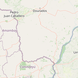
Map view of Cerro Corá National Park

Use this park location map to pinpoint Cerro Corá National Park in Paraguay, understand its exact geographic position, and read its mapped placement within the surrounding landscape more clearly.

Pigeon | © OpenStreetMap contributors
Park atlas

Compare regional park geography and trace connected conservation landscapes across Paraguay and nearby South American territories.

Explore Other National Parks and Protected Areas Surrounding Cerro Corá National Park

Browse additional national parks and protected areas near Cerro Corá National Park, exploring the regional context of diverse conservation landscapes across Paraguay and its geographical neighbors. A wider perspective supports detailed geographic comparison of various park features, offering a comprehensive view of protected terrain beyond one specific park.
National parkConcepción Department
About 116 km away#1 closest

West

Paso Bravo National Park: Protected Landscape Map and Regional Geographic Context

Exploring the diverse cerrado savanna and forest boundaries in northern Paraguay.

Paso Bravo National Park stands as the largest protected area in eastern Paraguay, offering significant insight into the cerrado and riparian landscape of the Concepción department. This reserve preserves essential habitat connectivity for large predators and diverse avian populations, marking a unique convergence of botanical heritage and subtropical wetland systems within the South American interior.

Area
1,030 km²
Established
1998
Climate
Subtropical
Scope
Terrestrial
Nature reserveCanindeyú Department
About 180 km away#2 closest

Southeast

Mbaracayú Forest Nature Reserve: A Detailed Geographic Atlas of Paraguay's Protected Forest

Mapped terrain, forest corridors, and landscape features

Spanning over 64,000 hectares in the Canindeyú Department, Mbaracayú Forest Nature Reserve preserves the core of the Alto Paraná Atlantic forest. The area features a complex mosaic of subtropical forest, riparian corridors, and the undulating slopes of the Cordillera de Mbaracayú range. This map-focused profile details the reserve's unique topography, stream networks, and its vital role as a continuous wilderness block in eastern Paraguay.

Area
644.05 km²
Established
1991
IUCN
II
Relief
Upland
Wildlife reserveCanindeyú Department
About 262 km away#3 closest

Southeast

Refugio Carapá Wildlife Reserve: Mapping Biological Diversity in Canindeyú Department

A protected sub-tropical mosaic along the Paraná River basin

Refugio Carapá protects a dramatic stretch of mountain slopes and riverine valleys in the Department of Canindeyú. By managing a mosaic of tall forests, swamps, and open camp vegetation, the reserve maintains a crucial ecological link within the wider Itaipu reservoir landscape. The area functions as a research-focused environment dedicated to preserving native flora and threatened species in eastern Paraguay.

Area
32.5 km²
Established
1984
Relief
Mountain
Climate
Subtropical
National parkFormosa Province
About 323 km away#4 closest

Southwest

Río Pilcomayo National Park: Protected Humid Chaco Wetland Landscape & Geography

Explore mapped boundaries and unique floodplain terrain in Formosa Province.

Río Pilcomayo National Park represents a significant protected natural area within Argentina's Formosa Province, characterized by the unique ecosystems of the Humid Chaco. The park's landscape is defined by extensive floodplains, marshes, lakes, and forests, all influenced by the Pilcomayo River's dynamic hydrological cycle. As a Ramsar site, it safeguards crucial habitats, including those for the endangered jaguar, and showcases iconic Caranday palm savannas. This detailed atlas entry provides insights into its mapped geography and the vital protected landscape it preserves.

Area
518.89 km²
Established
1951
IUCN
II
Relief
Lowland
Wildlife reserveAlto Paraná Department
About 340 km away#5 closest

Southeast

Tatí Yupí Refuge: Wildlife Reserve Geography and Paraná River Landscape

A 2,245 hectare protected biological forest in Alto Paraná

Tatí Yupí Refuge offers a unique perspective on protected land management within the Itaipu hydroelectric complex. Explore the mapped boundaries, basaltic stream formations, and subtropical forest habitat that define this essential ecological refuge in Paraguay's Alto Paraná Department.

Area
22.45 km²
Established
1982
Relief
Lowland
Climate
Subtropical
Natural monumentAlto Paraná Department
About 371 km away#6 closest

Southeast

Moisés Bertoni Scientific Monument: Protected Atlantic Forest in Alto Paraná, Paraguay

Natural monument and historic research landscape

Explore the geographic footprint of Moisés Bertoni Scientific Monument, an essential protected area in the Alto Paraná Department. This site safeguards mature Atlantic Forest ecosystems along the Paraná River while preserving the historic research station and cultural legacy of its founder. The monument remains a pivotal landmark for understanding the biodiversity and conservation landscape of eastern Paraguay.

Area
1.99 km²
Established
1955
Relief
Lowland
Climate
Subtropical
National parkMisiones Province
About 374 km away#7 closest

Southeast

Iguazú National Park: Argentina's Misiones Province Protected Landscape Atlas

Explore mapped boundaries and regional geography.

Iguazú National Park serves as a key protected natural area situated within Misiones Province. This MoriAtlas entry details its mapped geographic boundaries, contributing essential context for understanding its landscape identity. Users can explore how this national park fits into the regional geography, providing a factual basis for detailed atlas-based study of protected lands and their unique terrain.

Area
677 km²
Established
1934
IUCN
II
Relief
Lowland
National parkParaguay
About 383 km away#8 closest

South

Ypoá National Park: Paraguay's Protected Wetland Landscape and Lake Ecosystem

Explore mapped boundaries and significant bird habitats in the Ñeembucú region.

Ypoá National Park is a critical protected area in Paraguay, renowned for its extensive wetland ecosystems dominated by Lake Ypoá. This national park encompasses a rich mosaic of marshlands, riparian forests, and aquatic vegetation, making it a significant habitat for numerous bird species, including several rare and endemic types. Its designation as a Ramsar Wetland underscores its ecological importance, offering a unique lens for understanding landscape context and protected-area geography within South America.

Area
1,000 km²
Established
1992
IUCN
II
Relief
Lowland

Common questions about visiting, size, designation, and location context for Cerro Corá National Park

Cerro Corá National Park FAQs for park facts, access, geography, and protected area context

Find quick answers about Cerro Corá National Park, including protected-area facts, park geography, trail and visitor context, and how the park fits into its surrounding country and regional landscape.
MoriAtlas Explorer

Continue Your Protected Areas Search Across the Global Atlas

Deepen your exploration by continuing the structured search for national parks and protected areas worldwide. Utilize the comprehensive filtering capabilities to compare different conservation landscapes and refine your understanding of global park geography. Discover more about the distribution and characteristics of protected natural areas.

Global natural geography