Mori Atlas logo
Nature reserveCerro Pancasan Natural Reserve

Examining the hill-based terrain, watershed geography, and conservation status of this protected area

Cerro Pancasan Natural Reserve: A Detailed Atlas of Nicaragua's Protected Forest Hill Landscapes

Cerro Pancasan Natural Reserve represents a critical forested elevation within the Nicaraguan National System of Protected Areas. This protected landscape safeguards essential tropical dry forest habitats on the Pacific slope, serving as a vital catchment area that moderates local runoff and maintains critical watershed integrity. By focusing on its specific hill-based geography, this entry details the role of the reserve as part of the wider network of protected elevations that sustain biodiversity across the country.

tropical dry foresthill reservewatershed protectionPacific slopeSINAP reservecerro reserve

Cerro Pancasan Natural Reserve

Nature reserve

Park overview

Structured park overview, official facts, and landscape profile for Cerro Pancasan Natural Reserve

Cerro Pancasan Natural Reserve park facts, protected area profile, and essential visitor context

Review the core facts for Cerro Pancasan Natural Reserve, including designation, size, terrain, visitor scale, habitats, and operating context in one park-focused overview.

About Cerro Pancasan Natural Reserve

Cerro Pancasan Natural Reserve is a protected natural area in Nicaragua, formally recognized as part of the country's National System of Protected Areas, or SINAP. Nicaragua maintains one of Central America's more extensive systems of formally protected land, with 78 protected areas covering roughly 22,000 square kilometers, or about 17 percent of the national landmass. Within that system, the reserve occupies a place among the hill-and-mountain natural reserves, a category that reflects Nicaragua's approach of conserving not just its famous large parks and biosphere reserves, but also a network of smaller forested elevations that play outsized roles in watershed stability and dry forest biodiversity.

The reserve's setting centers on Cerro Pancasan itself, a hill in western Nicaragua whose name gives the protected area its identity. Like other cerro reserves nationwide, Cerro Pancasan protects a forested block of tropical habitat in a region where agriculture has replaced much of the original cover. These reserves are typically characterized by continuous forest on hillside topography, transitional elevations between the Pacific lowlands and interior highlands, and catchments that feed streams and rivers serving rural communities.

Within SINAP, the reserve is administered by MARENA, the Ministry of the Environment and Natural Resources, which oversees all of Nicaragua's public protected areas. Its broader significance is collective rather than singular: it is one link in a country-wide chain of reserves that, together with larger national parks and biological reserves, sustains forest cover, soil stability, and habitat for resident and migratory wildlife across the Pacific slope and northern highlands.

Quick facts and research context for Cerro Pancasan Natural Reserve

Cerro Pancasan Natural Reserve is a named protected area within Nicaragua's SINAP (National System of Protected Areas). It is listed alongside more than 70 other reserves, refuges, and national parks administered by MARENA, the Ministry of the Environment and Natural Resources.

The reserve is one of the many "Cerro" (hill or small mountain) type natural reserves in Nicaragua, which together protect smaller forested elevations across the country's interior rather than the larger volcanic massifs or biosphere reserves. As part of SINAP, it contributes to the national goal of maintaining at least roughly 17 percent of Nicaragua's landmass under formal protection, and it sits in the same administrative family as other cerro reserves such as Cerro Apante, Cerro Banacruz, Cerro Cola Blanca, Cerro Guabule, Cerro Kilambé, Cerro Mombachito–La Vieja, Cerro Musún, Cerro Quiabuc–Las Brisas, Cerro Silva, Cerro Tisey–Estanzuela, and Cerro Wawashang.

Protection and recognition

Review documented terrestrial protection metrics and official designation scope

Cerro Pancasan Natural Reserve Protection Status and Governance Framework

Terrestrial protection status records outline the administrative scope and official conservation framework governing Cerro Pancasan Natural Reserve. Structured metadata compiles verified boundary parameters, regulatory classifications, and international recognition details into a unified reference.

Protection details

Protection scope
Terrestrial
Park context

Deeper park guide and search-rich context for Cerro Pancasan Natural Reserve

Cerro Pancasan Natural Reserve history, landscape, wildlife, and travel context

Explore Cerro Pancasan Natural Reserve through its history, landscape character, ecosystems, wildlife, conservation priorities, cultural context, and seasonal travel timing in a structured park guide built for atlas discovery and search intent.

Why Cerro Pancasan Natural Reserve stands out

Cerro Pancasan Natural Reserve is primarily known as a hill-based, forest-protection reserve in Nicaragua's SINAP system, contributing to watershed conservation and dry tropical forest preservation on the country's Pacific slope. As one of many named "Cerro" natural reserves, it represents the country's strategy of protecting smaller forested elevations alongside its flagship national parks and biosphere reserves. Its identity within Nicaragua's conservation network is tied to this pattern: it is part of a constellation of cerro reserves that individually cover modest but ecologically meaningful forest tracts, and together help maintain habitat connectivity for resident and migratory species in a landscape dominated by agriculture and cattle ranching.

Cerro Pancasan Natural Reserve history and protected-area timeline

Nicaragua's modern protected-area system has expanded gradually over the late 20th and early 21st centuries. The country's first protected area, the Peninsula of Cosigüina Wildlife Refuge, was established in 1958. A handful more were added before 1979, when the roles and responsibilities of the state conservation bodies shifted at the end of the Somoza period. By 1990, Nicaragua had a total of 25 protected areas, several of which had originally been administered through the Central Bank of Nicaragua.

In March 1999, a new law generalized the framework for protected-area management in the country, including formal recognition of private wildlife reserves, defined as private lands dedicated to conservation and acknowledged by MARENA on the basis of biodiversity conservation criteria. Since then, the National System of Protected Areas (SINAP) has grown to include 78 officially recognized areas. Cerro Pancasan Natural Reserve is part of this system, but no independent establishment date or detailed institutional history for the specific reserve is documented in the available source material.

Cerro Pancasan Natural Reserve landscape and geographic character

Cerro Pancasan Natural Reserve takes its name from a hill, or "cerro," in western Nicaragua, and the protected area is built around that topographic feature. As a cerro reserve, it protects hillside forest rather than a flat lowland block or a coastline. The terrain is defined by slopes, ridges, and the drainage patterns that flow off the hill into surrounding lowlands, with elevation descending toward the Pacific plain.

The natural landscape context is typically one of tropical dry forest transitioning into more humid or montane communities at slightly higher elevations, a pattern common across many of Nicaragua's smaller cerro reserves. The reserve's importance for physical geography is largely tied to watershed function: by keeping the hill under continuous forest cover, the reserve helps moderate runoff, reduce erosion, and maintain stream flow in a region where deforestation is otherwise widespread. Without finer-grained elevation, area, or geometric data for this specific reserve, a more granular landscape description cannot be supported.

Cerro Pancasan Natural Reserve ecosystems, habitats, and plant life

Cerro Pancasan Natural Reserve sits within the broader ecological mosaic of western Nicaragua, where tropical dry forest is the dominant natural vegetation cover and has been heavily modified by centuries of agricultural use. As a cerro reserve, its ecological value lies in preserving a continuous block of forest cover on hill topography that would otherwise be vulnerable to clearing for cropland or pasture.

The reserve contributes to the country's forest-based habitat network, supporting the kinds of vegetation communities typical of Nicaragua's hill country: dry-forest deciduous and semi-deciduous canopy layers on lower and drier slopes, with more evergreen and humid-affiliated vegetation where elevation, slope aspect, or local moisture conditions allow. The reserve also connects with the wider SINAP framework, where cerro reserves and larger biosphere and biological reserves together maintain a system of habitat patches that support forest-dependent species at the regional scale.

Because no species inventory or detailed habitat mapping is available for this specific reserve in the source material, a finer ecological profile cannot be substantiated beyond this general pattern shared with other Nicaraguan cerro reserves.

Cerro Pancasan Natural Reserve wildlife and species highlights

As part of Nicaragua's protected-area network, Cerro Pancasan Natural Reserve likely supports representative dry-forest wildlife communities typical of the country's western hill country, including resident and migratory bird species, small and medium-sized mammals, and herpetofauna associated with tropical dry forest. Such reserves are generally recognized within SINAP as important for maintaining connectivity between larger protected blocks and for sustaining species in working landscapes heavily used for agriculture and grazing.

No specific, documented list of notable fauna is available for this particular reserve in the source material, and any detailed treatment of flagship or endemic species here cannot be supported without further sources.

Cerro Pancasan Natural Reserve conservation status and protection priorities

Cerro Pancasan Natural Reserve is recognized as part of Nicaragua's National System of Protected Areas (SINAP), the country's overarching framework for biodiversity and watershed conservation. It is administered by MARENA, the Ministry of the Environment and Natural Resources, which sets the regulatory and management standards for all SINAP areas.

Its conservation significance is essentially structural rather than iconic: rather than being a flagship site like a biosphere reserve or major national park, it is a small but meaningful piece of a much larger reserve mosaic. Together with neighboring cerro reserves and the country's bigger parks, it helps Nicaragua meet and maintain its national coverage target, under which roughly 17 percent of the country's land area falls within formal protection. The reserve's role in watershed stabilization, forest cover retention, and habitat continuity gives it clear local conservation value even in the absence of globally rare or endemic designations.

Cerro Pancasan Natural Reserve cultural meaning and human context

No specific cultural, indigenous, or community context for Cerro Pancasan Natural Reserve is documented in the available source material. The reserve's cultural dimension can only be inferred in broad terms, as part of a network of protected areas whose names and locations reflect regional and local geographic identifiers used across rural Nicaragua. A focused cultural narrative for this specific reserve cannot be supported.

Top sights and standout views in Cerro Pancasan Natural Reserve

Cerro Pancasan Natural Reserve is one of Nicaragua's named hill-based natural reserves within the SINAP system, contributing to national targets for protected land coverage and to watershed protection in its local catchment. Its name follows a recurring pattern across the country, in which hills and small mountains, the cerros, are individually protected to maintain forest cover, soil stability, and habitat in otherwise heavily modified agricultural landscapes.

Within the wider SINAP portfolio, the reserve sits with other cerro reserves such as Cerro Apante, Cerro Banacruz, Cerro Cola Blanca, Cerro Mombachito–La Vieja, Cerro Musún, and Cerro Wawashang, forming an extensive but distributed network of forested elevations that collectively sustain biodiversity and ecological function across western and northern Nicaragua.

Best time to visit Cerro Pancasan Natural Reserve

No specific seasonal or climate-related visitation guidance for Cerro Pancasan Natural Reserve is available in the source material. Like other Nicaraguan tropical dry forest reserves in the Pacific-slope region, the experience of visiting depends on the country's distinct dry and wet seasons, but a reliable, source-supported best-time profile cannot be provided here.
Monthly climate preview

Long-term temperature and precipitation averages measured across the protected reserve

Cerro Pancasan Natural Reserve Climate Normals and Weather by Month

Representative coordinate records show mean monthly temperatures ranging between 22.64 degrees and 26.52 degrees Celsius alongside distinct precipitation variations throughout the year. Reviewing the complete twelve-month profile provides deeper analytical context for long-term meteorological patterns across the landscape.
Annual mean24 °C
23 °C27 °C
Jan23°
Feb24°
Mar25°
Apr27°
May26°
Jun24°
Jul24°
Aug24°
Sep24°
Oct23°
Nov23°
Dec23°
Warmest month
April

26.5 °C

Coolest month
December

22.6 °C

Wettest month
September

6.8 mm/day

Driest month
January

0.2 mm/day

Park location guide

Geography guide, regional context, and park location map for Cerro Pancasan Natural Reserve

Cerro Pancasan Natural Reserve park geography, regions, and map view in Nicaragua

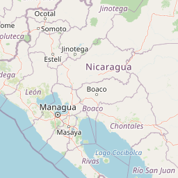
Understand where Cerro Pancasan Natural Reserve sits in Nicaragua through a broader geographic reading of the surrounding landscape, nearby location context, and its mapped position within the national park landscape.

How Cerro Pancasan Natural Reserve fits into Nicaragua

Nicaragua is a Central American country spanning 130,375 km² with a population of approximately 6.7 million. It borders Honduras, Costa Rica, the Caribbean Sea, and the Pacific Ocean. The official language is Spanish, and the currency is the Córdoba. Known for its agricultural productivity and cultural diversity, Nicaragua has a history dating back to indigenous civilizations before Spanish conquest in the 16th century.

Wider geography shaping Cerro Pancasan Natural Reserve in Nicaragua

Nicaragua occupies a strategic position in Central America, bordered by Honduras to the north, the Caribbean Sea to the east, Costa Rica to the south, and the Pacific Ocean to the west. The country also shares maritime borders with El Salvador and Colombia. The terrain includes coastal plains, volcanic highlands, and interior valleys. Lake Managua and Lake Nicaragua are major freshwater bodies.

Map view of Cerro Pancasan Natural Reserve

Use this park location map to pinpoint Cerro Pancasan Natural Reserve in Nicaragua, understand its exact geographic position, and read its mapped placement within the surrounding landscape more clearly.

Pigeon | © OpenStreetMap contributors
Recorded earthquake history

Explore Recorded Earthquake Data for Cerro Pancasan Natural Reserve

Examine the historical catalogue of seismic events identified within the vicinity of Cerro Pancasan Natural Reserve. This data collection by MoriAtlas enables a detailed look at past recorded earthquakes, including their magnitude and epicentre proximity, to help understand the regional seismic landscape.

Cerro Pancasan Natural Reserve Earthquake History

Catalogued events

3 events

Strongest magnitude

Magnitude 4.6

Most recent event

May 13, 2019

This history includes earthquakes recorded inside the park or within 50 km of its borders

Park atlas

Compare surrounding hill reserves and regional forest landscapes across western Nicaragua

Other Protected Areas and Parks Near Cerro Pancasan Natural Reserve

Browsing parks near Cerro Pancasan Natural Reserve reveals connected forested elevations and regional watershed protection units across western Nicaragua. Extending the geographic comparison helps trace similar hill reserves and tropical dry forest habitats within the national conservation network.
A horizontal watercolor painting showing layers of distant misty mountains behind a foreground of dense tropical foliage and palm-like plants.
Biosphere reserveJinotega Department
85 km away#1 closest

North

Bosawás Biosphere Reserve: Mapping Tropical Rainforest Landscapes and Regional Geography

Extensive primary forest and mountainous terrain in Nicaragua

Examine the geographic layout and protected boundaries of Bosawás Biosphere Reserve. Spanning nearly 20,000 square kilometers across Jinotega Department, this massive biosphere reserve includes the Saslaya massif and essential watersheds, serving as a critical study of tropical rainforest preservation and complex highland topography.

Area
20,000 km²
Established
1997
IUCN
IV
Relief
Mountain
A soft watercolor painting of a calm lake surrounded by rolling hills and distant mountains, with light vegetation in the foreground.
Nature reserveNicaragua
116 km away#2 closest

Southwest

Laguna de Apoyo Nature Reserve: Geographic Profile and Protected Volcanic Caldera

A study of volcanic lake hydrology and tropical dry forest terrain.

Laguna de Apoyo Nature Reserve is a prominent protected landscape in Nicaragua, centered on a deep crater lake of volcanic origin. This nature reserve protects a circular caldera filled by an endorheic lake, ringed by diverse tropical dry forest. The area serves as a significant site for understanding geological landforms and the specialized freshwater biodiversity found within its sheltered basin.

Area
35 km²
Established
1991
IUCN
IV
Relief
Mixed relief
National parkHonduras
118 km away#3 closest

North

Patuca National Park National Park: Understanding its Mapped Protected Boundaries and Honduran Geography

Explore the protected landscape and regional setting of this Honduran park.

Patuca National Park is an important protected area within Honduras, offering a unique opportunity to study its geographic features and conservation significance. As a national park, it provides a critical anchor for understanding regional landscape patterns and mapped protected boundaries in Central America. This entity within the MoriAtlas helps users grasp the specific geographic context and natural terrain associated with Patuca National Park, facilitating detailed atlas-based exploration of its protected status and landscape character.

Area
3,755.84 km²
Established
1999
IUCN
II
Scope
Terrestrial
Nature reserveManagua Department
About 119 km away#4 closest

Southwest

Chocoyero-El Brujo Natural Reserve: Geographic Overview and Protected Landscape Mapping

Tropical ravine forest and critical watershed in Managua Department.

This nature reserve protects a vital intersection of tropical forest and steep ravine terrain. Centered on the iconic El Brujo and Chocoyero waterfalls, the area acts as a crucial watershed and nesting ground for green parakeet colonies. The compact, vertical landscape provides a unique look at how small protected areas maintain biodiversity and regional water security near the capital of Nicaragua.

Area
1.8 km²
Established
1993
Visitors
10K annual
Relief
Upland
National parkNicaragua
About 120 km away#5 closest

Southwest

Masaya Volcano National Park: Nicaragua National Park Atlas & Landscape Context

Explore the mapped boundaries of this unique volcanic terrain.

Masaya Volcano National Park offers a distinct focus for atlas exploration within Nicaragua's broader geographic framework. This page details the park's identity as a protected landscape, highlighting its volcanic terrain and mapped features. Understand its significance within the national park system and its contribution to the mapped natural heritage of Central America.

IUCN
II
Relief
Mountain
Access
Access unknown
National parkNicaragua
About 133 km away#6 closest

South

Zapatera Archipelago National Park: Nicaragua National Park Atlas and Protected Landscape Explorer

Explore the mapped boundaries and regional geography.

Zapatera Archipelago National Park serves as a distinct national park within Nicaragua, offering a focused point for exploring protected landscapes and their geographic context. This entry details the park's mapped boundaries and its significance within the atlas of Central American natural areas. Users can understand its role as a protected entity and its contribution to the region's mapped geography, supporting structured discovery of its natural landscape identity.

IUCN
II
Climate
Tropical
Scope
Mixed
Water
Water-dominated
Nature reserveChinandega Department
198 km away#7 closest

West

Estero Padre Ramos Natural Reserve: Protected Coastal Estuary and Turtle Habitat in Nicaragua

Mangrove forests and tidal landscapes of the Pacific coast

Gain insights into the geography and protected status of Estero Padre Ramos Natural Reserve. This coastal sanctuary in the Chinandega Department features pristine estuarine channels, mudflats, and rocky reefs that define the local terrain and support international marine turtle conservation efforts.

Area
91.57 km²
Established
1983
IUCN
IV
Relief
Lowland
National parkGuanacaste Province
205 km away#8 closest

South

Guanacaste National Park: A Protected Landscape within Guanacaste Province's Geography

Explore mapped park boundaries and regional natural landscape context.

Delve into the protected landscape of Guanacaste National Park, a significant national park located within Guanacaste Province. This entry provides a focused view of its geographic features, mapped protected areas, and its role within the regional terrain. Understand the park's specific natural landscape character and its placement in the broader atlas of conservation lands.

Area
340 km²
Established
1991
IUCN
II
Relief
Mixed relief

Common questions about visiting, size, designation, and location context for Cerro Pancasan Natural Reserve

Cerro Pancasan Natural Reserve FAQs for park facts, access, geography, and protected area context

Find quick answers about Cerro Pancasan Natural Reserve, including protected-area facts, park geography, trail and visitor context, and how the park fits into its surrounding country and regional landscape.
MoriAtlas Explorer

Continue Your Protected Areas Search Across the Global Atlas

Deepen your exploration by continuing the structured search for national parks and protected areas worldwide. Utilize the comprehensive filtering capabilities to compare different conservation landscapes and refine your understanding of global park geography. Discover more about the distribution and characteristics of protected natural areas.

Global natural geography