Mori Atlas logo
National parkChad Basin National Park

Discover the mapped boundaries and regional context of this Nigerian national park.

Chad Basin National Park: Nigeria's Protected Landscape and Geographic Identity

Chad Basin National Park stands as a designated national park within Nigeria, offering a unique focal point for exploring protected landscapes. This entity represents a specific area of natural terrain, contributing to the country's broader geographic mosaic. By examining Chad Basin National Park, users can engage with structured data about its protected-area status and its place within the regional context of Nigeria, facilitating atlas-style discovery and understanding of its mapped geography.

National ParkWetlandsSavannaMigratory BirdsTransboundary ConservationBlack Crowned Crane

Chad Basin National Park

National park

Park overview

Structured park overview, official facts, and landscape profile for Chad Basin National Park

Chad Basin National Park park facts, protected area profile, and essential visitor context
Review the core facts for Chad Basin National Park, including designation, size, terrain, visitor scale, habitats, and operating context in one park-focused overview.

About Chad Basin National Park

Chad Basin National Park represents Nigeria's commitment to preserving the ecological diversity of the Chad Basin region, a vast area of savanna and wetlands that surrounds Lake Chad, one of Africa's largest lakes. The park's three sectors are dispersed across northeastern Nigeria, each protecting different aspects of the region's natural heritage. The Chingurmi-Duguma sector, the largest at 1,228 square kilometers, occupies a transitional zone where Sahel and Sudanian-Guinea savanna ecosystems meet, creating a diverse habitat mosaic of Acacia-Balanites woodlands, elephant grass stands, and seasonal floodplains. The Bade-Nguru Wetlands sector encompasses nearly 938 square kilometers of marshes, lakes, and forest reserves that form part of the Hadejia-Nguru wetlands complex, a recognized Important Bird Area. The Bulatura sector, at just 92 square kilometers, protects a unique landscape of scenic sand dunes interspersed with swampy valleys containing potash deposits. Together, these sectors aim to conserve both the biological resources and the traditional land-use patterns of the region, though the park faces significant challenges from incomplete boundary demarcation, human encroachment, and regional security concerns that have periodically suspended park operations.

Quick facts and research context for Chad Basin National Park

Chad Basin National Park spans roughly 2,258 square kilometers across northeastern Nigeria, divided into three distinct sectors in Borno and Yobe states. The Chingurmi-Duguma sector lies in the Sudanian savanna zone and includes flood-plain wetlands fed by the Dorma River. The Bade-Nguru Wetlands sector forms part of the larger Hadejia-Nguru wetlands system, important for migratory waterbirds. The smallest Bulatura sector features distinctive swampy valleys separated by sand dunes. The park was established in 1991 and has struggled with boundary demarcation, low visitation due to regional insecurity, and competition between human land use and wildlife conservation.

Park context

Deeper park guide and search-rich context for Chad Basin National Park

Chad Basin National Park history, landscape, wildlife, and travel context
Explore Chad Basin National Park through its history, landscape character, ecosystems, wildlife, conservation priorities, cultural context, and seasonal travel timing in a structured park guide built for atlas discovery and search intent.

Why Chad Basin National Park stands out

Chad Basin National Park is best known for its role in protecting critical wetlands within the Sahel region, particularly the Bade-Nguru Wetlands which serve as a vital rest stop for migratory birds along the East Atlantic flyway. The Chingurmi-Duguma sector supports significant populations of the vulnerable black crowned crane, while the overall park provides connectivity between Nigerian and Cameroonian protected areas near the Waza National Park border. The park's fragmented nature and its location spanning two distinct ecological zones, Sudanian savanna and Sahel, make it an important but challenging conservation area in West Africa.

Chad Basin National Park history and protected-area timeline

Chad Basin National Park was established in 1991 as part of Nigeria's efforts to create a comprehensive national park system. The park was formed by combining several previously designated protected areas, including the Chingurmi-Dugoma Game Reserve, the Gorgoram and Zurgun Baneri Forest Reserves, and the Bulature Oasis. The land within the park has a deep historical significance, lying within the boundaries of the former Kanem-Bornu Empire, one of Africa's most enduring and politically sophisticated empires. The empire emerged before the 10th century and persisted until the late 19th century, controlling territory across what is now northeastern Nigeria and surrounding regions. Following Nigerian independence and subsequent park management planning, the protected area was elevated to national park status in 1991. However, the park has faced significant operational challenges, including incomplete boundary surveys, minimal investment in visitor infrastructure, and regional insecurity that led to the temporary suspension of operations and research in 2021.

Chad Basin National Park landscape and geographic character

The physical landscape of Chad Basin National Park varies significantly across its three sectors, reflecting the park's position at the intersection of two major African ecological zones. The Chingurmi-Duguma sector exhibits a stratified topology, with the northern portion lying in the Sahel zone characterized by drier, more sparse vegetation, while the southern sector displays typical Sudan-Guinea savanna ecology with denser Acacia-Balanites woodlands. Seasonal flooding from the Dorma river creates extensive flood-plain wetlands that transform the landscape during the rainy season. The Bade-Nguru Wetlands sector contains a complex of marshes, seasonal lakes, and watercourses that constitute part of the larger Hadejia-Nguru wetland system. The Bulatura sector presents the most distinctive visual character, with a series of swampy valleys separated by sweeping sand dunes, creating a visually striking contrast between the lush valley bottoms and the golden sandy ridges.

Chad Basin National Park ecosystems, habitats, and plant life

The ecological character of Chad Basin National Park reflects its position in the Chad Basin, a region of transitional ecosystems between the Sahara Desert to the north and the Sudanian savanna to the south. The Chingurmi-Duguma sector straddles this transition, supporting woodland savanna characterized by Acacia and Balanites trees interspersed with dense elephant grass and sorghum cultivation. The seasonal floodplains create important wetland habitats that persist during and after the rainy season from late May through September, when annual rainfall ranges between 200 and 600 millimeters across the park. The Bade-Nguru Wetlands sector contains the Dagona Waterfowl Sanctuary and five forest reserves, providing critical habitat for waterbirds and maintaining forest cover in an otherwise predominantly grassy landscape. However, the park's ecosystems face significant pressure from agricultural expansion, reduced flooding due to upstream dam construction, and the impacts of climate change on rainfall patterns.

Chad Basin National Park wildlife and species highlights

Chad Basin National Park supports a range of wildlife species, with particular significance for waterbirds and large mammals. The Chingurmi-Duguma sector is notable for its population of black crowned cranes, a vulnerable species that remains abundant in the area despite its precarious conservation status. The wetlands attract large numbers of migratory birds during the winter months, including demoiselle cranes and white storks that use the area as a resting and feeding ground along their migration routes. Helmeted guineafowl are resident throughout the sector. A 2007 survey estimated approximately 100 elephants in the Chingurmi-Duguma sector, with individuals potentially migrating between the park and adjacent Waza National Park in Cameroon. The Bade-Nguru Wetlands provide crucial habitat for numerous waterfowl species, though the ecosystem faces growing pressures from human-wildlife conflict, particularly as farmers attempt to control Quelea quelea populations through poisoning, inadvertently affecting non-target species.

Chad Basin National Park conservation status and protection priorities

Chad Basin National Park represents an important conservation designation within Nigeria's protected area network, particularly for the Sahel and Sudanian savanna ecosystems that have limited formal protection across West Africa. The park's inclusion of the Bade-Nguru Wetlands connects it to broader regional conservation efforts for this critical wetland system, recognized internationally for its role in supporting migratory bird populations. However, the park faces substantial conservation challenges. Boundary demarcation remains incomplete since its establishment, making effective protection difficult. Human pressure is intensifying as agricultural expansion encroaches on marginal lands and forest reserves experience declining tree cover. Reduced flooding from upstream dam development has altered wetland hydrology, while climate change affects rainfall patterns across the region. The park's proximity to Cameroon has prompted cross-border cooperation between Nigerian and Cameroonian authorities to address poaching and raise local conservation awareness, with discussions ongoing about potential international designation of the Chingurmi-Duguma sector and Waza National Park as a transboundary protected area.

Chad Basin National Park cultural meaning and human context

The landscape now encompassed by Chad Basin National Park carries deep historical significance as part of the former Kanem-Bornu Empire, which controlled this region of northeastern Nigeria for nearly a thousand years. The empire emerged before the 10th century and developed sophisticated political structures comparable to other major African empires like Mali and Songhai. The conventional Basin of Lake Chad, where the park is situated, served as the heartland of this empire and supported its agricultural and trading base. Today, the park region remains populated by communities engaged in farming, grazing, and fishing, activities that both depend on and compete with the park's natural resources. The traditional land-use patterns of these communities are woven into the landscape, though changing economic conditions, population growth, and environmental shifts are reshaping the human-environment relationship within the park's boundaries.

Top sights and standout views in Chad Basin National Park

Chad Basin National Park offers distinctive features that set it apart within Nigeria's protected area system, including its fragmented structure spanning three sectors across two states and two ecological zones. The Bade-Nguru Wetlands provide internationally significant habitat for migratory waterbirds, with the Dagona Waterfowl Sanctuary serving as a key resting area along major flyways. The Chingurmi-Duguma sector supports one of the more significant populations of the vulnerable black crowned crane in West Africa, set against a backdrop ofAcacia-Balanites woodlands and seasonal floodplains. The park's potential as a transboundary conservation area linking with Cameroon's Waza National Park represents an important opportunity for regional wildlife management. The Bulatura sector's landscape of sand dunes and swampy valleys offers a visually distinctive environment not commonly associated with West African protected areas.

Best time to visit Chad Basin National Park

The optimal time to visit Chad Basin National Park coincides with the dry season from November through April, when wildlife viewing opportunities are most favorable and access to park sectors is easier. The rainy season from late May through September transforms the landscape, particularly in the Chingurmi-Duguma sector where floodplain wetlands expand and attract concentrations of waterbirds, though road access can become difficult and some areas may be inaccessible. Migratory birds, including white storks and demoiselle cranes, are present during the winter months from approximately November to March. Visitors should note that park operations have been periodically suspended due to regional security concerns, and infrastructure remains limited across all sectors. Those planning visits should check current operational status and be prepared for basic facilities, including camping equipment for overnight stays.
Park location guide

Geography guide, regional context, and park location map for Chad Basin National Park

Chad Basin National Park park geography, regions, and map view in Nigeria
Understand where Chad Basin National Park sits in Nigeria through a broader geographic reading of the surrounding landscape, nearby location context, and its mapped position within the national park landscape.

How Chad Basin National Park fits into Nigeria

Nigeria is a West African federal republic spanning 923,769 km² between the Sahel and the Gulf of Guinea. It is Africa's most populous nation with over 236 million residents, composed of diverse ethnic groups including Hausa, Yoruba, Igbo, and numerous others. The country operates as a federal presidential republic with 36 states and the Federal Capital Territory, using English as its official language and possessing significant linguistic diversity with over 525 indigenous languages.

Wider geography shaping Chad Basin National Park in Nigeria

Nigeria occupies West Africa between the Sahel region to the north and the Gulf of Guinea in the Atlantic Ocean to the south. It shares borders with Niger to the north, Chad to the northeast, Cameroon to the east, and Benin to the west. The country covers an area of 923,769 square kilometres.

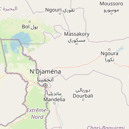
Map view of Chad Basin National Park

Use this park location map to pinpoint Chad Basin National Park in Nigeria, understand its exact geographic position, and read its mapped placement within the surrounding landscape more clearly.

Pigeon | © OpenStreetMap contributors

Location context for Chad Basin National Park

Borno StateYobe State
Park atlas

Trace diverse protected landscapes, including wetlands, savannas, and transboundary conservation efforts in the broader Chad Basin region.

Explore Other National Parks and Protected Areas Near Chad Basin National Park, Nigeria
Continue your exploration beyond Chad Basin National Park to discover other national parks and protected areas across Nigeria's Sahel and Sudanian savanna zones, including those connecting to transboundary conservation efforts. Comparing these distinct protected landscapes provides valuable context for understanding regional biodiversity, unique wetland systems, and broader conservation challenges in West Africa.
National parkFar North Region

Waza National Park: A Designated Protected Landscape in the Far North Region

Mapped Boundaries and Regional Geographic Context

Waza National Park stands as a vital protected natural landscape in Cameroon's Far North Region. This entry provides a deep dive into its mapped protected-area boundaries and its significance within the broader regional geography. Explore the specific landscape identity of this national park through an atlas-focused lens, understanding its terrain and context without travel logistics or visitor advice.

Area
1,700 km²
Established
1934
IUCN
II
Relief
Lowland
National parkCameroon

Bouba Njida National Park: A Protected Landscape within Cameroon's National Park Atlas

Discover its mapped geography and regional context.

Bouba Njida National Park represents a key component of Cameroon's protected lands, contributing essential context to any atlas of Central African geography. As a designated national park, it offers a distinct focus for understanding mapped landscape features and the distribution of protected areas within the country. This park serves as a vital point of reference for exploring the nation's natural terrain and its significance within the broader context of regional conservation efforts.

Area
2,200 km²
Established
1980
IUCN
II
Relief
Upland
Watercolor illustration of a landscape with rolling hills, a winding river, and varied terrain in soft colors
National parkBénoué Department

Bénoué National Park: Protected Landscape Atlas in Bénoué Department, Cameroon

Explore savanna woodland, riparian ecosystems, and geographic context.

Bénoué National Park is a vast protected landscape in Cameroon, defined by its Sudanian savanna woodland and significant frontage along the Bénoué River. Recognized as a UNESCO Biosphere Reserve, it offers critical insights into regional geography, habitat diversity, and the broader atlas of conservation lands in West Africa. Users can explore its varied terrain, from riverine zones to higher massifs, gaining a detailed understanding of this important protected area.

Area
1,800 km²
Established
1968
IUCN
II
Relief
Mixed relief
National park

Faro National Park: Central Africa's Largest Hippo Population within Sudano-Sahelian Protected Landscape

Explore mapped boundaries and regional geography of this vital national park.

Faro National Park stands as a critical protected area within Cameroon, celebrated for its immense hippopotamus population and its role in conserving large mammals across the Sudano-Sahelian zone. The park's landscape comprises undulating savanna plains, river valleys, and elevated hilltops, offering a diverse geographic context for conservation. Its inclusion in a transboundary protected network highlights its importance for regional landscape mapping and ecological continuity. Understanding Faro National Park involves appreciating its unique habitat mosaic and its contribution to the protected areas atlas.

Area
3,418 km²
Established
1989
IUCN
II
Relief
Upland
National parkMoyen-Chari Region

Manda National Park: National Park Protected Landscape and Geographic Identity in Moyen-Chari

Discover mapped terrain and regional context for this Chad national park.

Manda National Park, a protected natural area within Chad's Moyen-Chari Region, offers valuable insights into regional geography and mapped protected landscapes. This detail page provides focused information on the park's identity as a national park, emphasizing its geographic setting and the importance of its mapped boundaries for structured atlas exploration. Understand how this protected area contributes to the diverse natural terrain of the Moyen-Chari Region.

Area
1,140 km²
Established
1969
IUCN
II
Climate
Tropical
National parkGuéra Region

Zakouma National Park: Chad's Premier National Park and Protected Landscape

Explore the mapped savanna, acacia forests, and wildlife geography.

Zakouma National Park is Chad's oldest and most ecologically vital protected area, spanning 3,000 square kilometers of Sudano-Sahelian landscape. Situated within the Guéra Region, it is globally recognized for its exceptional Kordofan giraffe population, significant elephant recovery, and ongoing conservation successes, offering a unique view into African wildlife and protected area management.

Area
3,000 km²
Established
1963
IUCN
II
Relief
Lowland
National parkChad

Aouk National Park National Park: Mapped Protected Landscape and Regional Geography

Explore Chad's Aouk National Park boundaries and terrain.

Investigate Aouk National Park, a significant national park in Chad, through its detailed mapping and protected landscape attributes. This entry provides insight into the park's geographic placement within Central Africa, emphasizing its role as a conservation area. Users can explore the mapped boundaries and regional geographic context, facilitating a structured understanding of this protected territory for atlas-based research and discovery.

Area
7,400 km²
IUCN
II
Access
Moderate access
Scope
Terrestrial
National park

Deng Deng National Park: Protected Landscape & Gorilla Habitat in East Cameroon

Discover the mapped geography and conservation significance of this national park.

Deng Deng National Park in Cameroon's East Region offers a unique glimpse into the Northern Congolian forest-savanna mosaic ecoregion. Spanning about 683 square kilometers and shaped by the Sanaga River, it is critically important as the northernmost known habitat for western lowland gorillas. Its diverse terrain supports not only gorillas but also elephants, chimpanzees, and pangolins, highlighting its role in Central African biodiversity and regional landscape context.

Area
682.64 km²
Established
2010
IUCN
II
Climate
Tropical

Common questions about visiting, size, designation, and location context for Chad Basin National Park

Chad Basin National Park FAQs for park facts, access, geography, and protected area context
Find quick answers about Chad Basin National Park, including protected-area facts, park geography, trail and visitor context, and how the park fits into its surrounding country and regional landscape.
MoriAtlas Explorer

Continue Your Protected Areas Search Across the Global Atlas

Deepen your exploration by continuing the structured search for national parks and protected areas worldwide. Utilize the comprehensive filtering capabilities to compare different conservation landscapes and refine your understanding of global park geography. Discover more about the distribution and characteristics of protected natural areas.

Global natural geography