

Mori Atlas logo
Wildlife reserveChanga Manga

Tracing the boundaries and conservation geography of a historic plantation forest and wildlife sanctuary

Changa Manga Wildlife Reserve and the Man-Made Forest Landscapes of the Punjab Plains

Changa Manga serves as a significant protected area within the Punjab province, representing one of the oldest hand-planted forests globally. Originally established as an industrial plantation for the railway network, the area now functions as a vital refuge for biodiversity and conservation, notably including breeding efforts for the critically endangered white-rumped vulture. This overview examines the topography of its alluvial plains, its structured forest canopy, and its role as a persistent ecological site within the regional geography of Pakistan.

man-made forestplantation forestwildlife reservevulture conservationIndomalayan realmPunjab plains

Changa Manga

Wildlife reserve

Park overview

Structured park overview, official facts, and landscape profile for Changa Manga

Changa Manga park facts, protected area profile, and essential visitor context

Review the core facts for Changa Manga, including designation, size, terrain, visitor scale, habitats, and operating context in one park-focused overview.

About Changa Manga

Changa Manga sits on the flat, irrigated alluvial plains of central Punjab in eastern Pakistan, between the Lahore-Karachi railway corridor and the towns of Chunian and Bhai Pheru. Although it carries the trappings of a natural forest, it is in fact a deliberate man-made plantation created in the nineteenth century to supply timber and fuel for the railways of British India. Today it blends that industrial-plantation heritage with an active role as a wildlife reserve and a popular day-trip destination for visitors from Lahore.

What sets Changa Manga apart from most other protected areas in Pakistan is the combination of a long multi-species planted forest, an unusual narrow-gauge railway that was never removed, and a serious international conservation program. The trees have been harvested in cycles for more than a century, while still supporting a community of deer, jackals, peafowl, and vultures within and around the working plantation. The forest is administered by the Punjab Forest Department and straddles the boundary between Kasur District and Lahore District, giving it a position between one of Pakistan's largest cities and its agricultural hinterland.

Equally important to Changa Manga's identity is the long-running battle over its canopy. Once cited as the largest artificial forest in the world, it has lost large tracts of mature plantation to illegal logging, encroachment, and uncontrolled grazing, prompting official inquiries, anti-corruption investigations, and a recent program of replanting, fencing, and water-management reforms aimed at bringing the forest back. That tension between heavy historical use, active conservation, and recent recovery gives the site a complex and evolving character that is unusual among the country's protected natural areas.

Quick facts and research context for Changa Manga

Changa Manga is a man-made plantation forest and wildlife reserve in the Punjab plains of Pakistan, located in Kasur and Lahore districts between Chunian and Bhai Pheru off the N-5 Highway. It was established in 1866 under Dr. John Lindsay Stewart and Berthold Ribbentrop to supply timber fuel for the North-Western Railway, and today it remains under the Punjab Forest Department. The forest originally covered an area approaching 12,000 acres and was once cited as the largest artificial forest in the world before decades of illegal logging reduced it significantly. It contains a vulture conservation center run jointly by WWF Pakistan and the Punjab wildlife authorities, as well as a small wildlife reserve built in 2008.

Protection and recognition

Terrestrial conservation framework and international recognition history

Changa Manga Protection Status and Documented Protected Area Designation

Changa Manga operates under a defined terrestrial protection framework with documented management scope and conservation oversight. Analysis of official records details the administrative designation history and international recognition status associated with the protected landscape.

Protection details

Protection scope
Terrestrial
Transboundary protection
No
Park context

Deeper park guide and search-rich context for Changa Manga

Changa Manga history, landscape, wildlife, and travel context

Explore Changa Manga through its history, landscape character, ecosystems, wildlife, conservation priorities, cultural context, and seasonal travel timing in a structured park guide built for atlas discovery and search intent.

Why Changa Manga stands out

Changa Manga is best known for two rather distinct identities: as one of the world's oldest and at one point largest hand-planted forests, created on the Punjab plains to feed colonial-era railway engines; and as a modern conservation site for the critically endangered white-rumped vulture, with one of only a few dedicated breeding centers for that species in South Asia. Beyond these defining roles, the forest is recognized for its very productive mixed plantation of sheesham, kikar, and mulberry, and for the narrow-gauge forestry railway that still runs through the canopy. Together, these features make Changa Manga a textbook example of a working industrial plantation that has had to reinvent itself as a wildlife refuge and recreational site.
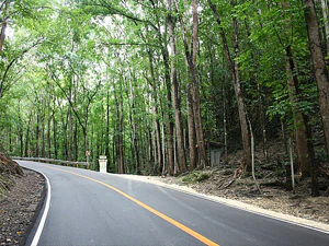
A smooth asphalt road curves through a dense, tall forest of mature trees in Changa Manga.
A paved road winds through the dense, man-made forest of Changa Manga.

Changa Manga history and protected-area timeline

Changa Manga's history begins in 1864, when the North-Western Railway was struggling to source fuel for its expanding network of steam services. Dr. John Lindsay Stewart, the first Conservator of Forests in Punjab, recommended that a dedicated plantation be set aside for each railway district. The block allocated for Kasur District was a semi-desert of thorn scrub and light alluvial soil in Chunian Tehsil, occupied at the time by Gondhal and Sansi communities whom the British referred to as 'junglies' before displacing them with cultivators from older settled lands.

Planting began in 1866 under Berthold Ribbentrop, Inspector General of Forests in British India, initially focusing on mulberry and sheesham across about 8,400 acres. Early results were disappointing until Charles Frederick Amery introduced a trench-and-ridge system in 1868 that transformed the productivity of the plantation; by 1888 the first successful rotation was harvested. A narrow-gauge forestry railway, later known as the Changa Manga Forestry Railway, was laid down to move logs to the main line, initially hauled by wood-burning John Fowler locomotives and later by coal-fired engines after fire damage to rolling stock.

The 1876–78 Great Famine intensified British interest in expanding rail infrastructure across India, raising demand for firewood from Changa Manga. In the early twentieth century the Salvation Army, led by Commissioner Frederick Booth-Tucker, ran a silk experiment at the forest from 1912, importing French silkworm eggs and feeding them on locally felled mulberry; the project drew praise from Punjab Governor Sir Michael O'Dwyer before climatic changes ended the venture. Much later, in 2011, a media exposé of illegal deforestation led the Punjab Ombudsman to take suo moto notice and the Chief Minister to order removals and investigations, followed by a multi-year campaign of boundary fencing, replanting, and water and grazing reforms. A small dedicated vulture breeding center opened within the forest in 2007, becoming the centerpiece of its modern conservation role.

Changa Manga landscape and geographic character

Changa Manga lies on the flat alluvial plains of the Punjab, a landscape of low, almost imperceptible relief shaped by centuries of river deposition and irrigation works. The native setting was once a mosaic of dry thorn scrub and seasonal grasses on light, easily worked soil, transformed through land clearance and trench irrigation into a uniform man-made woodland. The canopy now extends across roughly 5,000 hectares of artificially straightened plantation, divided into blocks and broken up by irrigation channels, roads, and the narrow-gauge railway corridor.

Vegetation patterning is highly deliberate. Rows of sheesham and kikar dominate the bulk of the plantation, with introduced mulberry, eucalyptus, and poplar lining many edges and internal tracks. The result is a dense, regulated forest rather than a wild tangle: straight lines, uniform spacing, and a consistent understory, with a few ornamental planting strips along the tramway for visitors approaching the recreation area. Small artificial lakes such as the so-called Lunar Lake, along with a waterfall feature and picnic clearings, add a distinctly designed quality to a small portion of the otherwise working forest.

Changa Manga ecosystems, habitats, and plant life

Ecologically, Changa Manga belongs to the Indomalayan realm and represents one of the most substantial artificially maintained dry deciduous forest patches left on the Punjab plains. Its mix of native and introduced broadleaf trees provides a structurally complex habitat uncommon in the surrounding intensively farmed countryside, where mature tree cover has largely been removed. The plantation's mulberry stands in particular are ecologically significant, as they sustain both leaf-feeding invertebrates and the bird populations that depend on insect-rich canopies.

The forest's habitats range from closed-canopy sheesham-kikar woodland and scattered eucalyptus groves to open glades, irrigation drains, and the edges of the small lakes and recreation areas. This patchwork supports a richer fauna than the surrounding agricultural matrix, especially where undisturbed interior blocks remain. While the plantation is not a wilderness ecosystem in the conventional sense, it functions ecologically as a refuge island in a heavily cultivated landscape, supporting both resident species and seasonal visitors that use the canopy as a stepping stone across the plains.

Changa Manga wildlife and species highlights

Changa Manga supports a mixed community of mammals, birds, reptiles, and amphibians that makes effective use of its planted forest and small protected enclosures. Mammals recorded in and around the reserve include hog deer, golden jackal, mouflon, nilgai, and wild boar, with hog deer, jackal, and peafowl especially associated with the dedicated wildlife preserve established in 2008. Indian peafowl are among the reserve's most visible birds and have become emblematic of the forest for visitors.

The site's most consequential wildlife role, however, centers on vultures. Changa Manga hosts the Gyps Vulture Conservation Centre, a dedicated facility for the critically endangered white-rumped vulture (Gyps bengalensis), run as part of the WWF-led Saving Asia's Vultures from Extinction programme. Although Asiatic vulture populations have collapsed by more than 90 percent across South Asia since the early 2000s, the centre's aviaries hold breeding pairs in a secluded part of the forest, with capacity for significantly more birds. Beyond vultures, the broader forest supports an assemblage of typical Punjab-plain birds, alongside six reptile and two amphibian species, giving Changa Manga an outsized conservation footprint relative to its size and modified character.

Changa Manga conservation status and protection priorities

Changa Manga's conservation significance extends well beyond its 2008 wildlife reserve boundary. As one of the largest and oldest deliberately planted forests on the Indo-Gangetic plains, it remains ecologically important in a region where natural woodland has been almost entirely replaced by cropland. The forest offers a sizable refuge of mature trees, understory, and associated fauna that acts as a stepping stone across an otherwise heavily cultivated landscape.

Its international profile in conservation, however, comes mainly from vulture work. Asiatic vulture populations have declined catastrophically across South Asia, and the Gyps Vulture Conservation Centre at Changa Manga is one of the few sites in Pakistan participating in coordinated captive breeding efforts through WWF Pakistan, the Punjab Wildlife and Parks Department, the Environment Agency Abu Dhabi, the Hawk Conservancy Trust, and WWF USA. The forest has also been a focus of recent anti-deforestation campaigns: after years of illegal logging reduced its extent dramatically, the authorities have fenced long stretches of boundary, secured additional irrigation flows, ejected grazing animals, and undertaken large-scale replanting of poplar and other species under the Billion Tree afforestation effort.

Changa Manga cultural meaning and human context

The forest's very name reflects a piece of local folklore: 'Changa Manga' is said to derive from two nineteenth-century brother dacoits, or bandits, who used the forest as a hideout and preyed on traders passing through the Punjab. Their eventual capture made the locality famous, and the Salvation Army later opened a camp on the site as part of its work rehabilitating offenders, an unusual chapter in which criminal legend and reformist moral work became intertwined with the landscape.

The plantation itself was also an instrument of colonial settlement. The local Gondhal and Sansi populations were displaced to make way for imported cultivators who would tend the new timber crop, a process that recast both the land and its human community. Today Changa Manga sits between rural Chunian and the sprawling metropolis of Lahore, and it functions as a readily accessible green space for day-trippers from the city, where the Tourism Development Corporation of Punjab runs regular picnic outings and the surviving narrow-gauge railway doubles as a heritage attraction.

Top sights and standout views in Changa Manga

Changa Manga's standout features include its origins as one of the world's oldest hand-planted forests, created in 1866 to supply railway fuel; its continued production of sheesham, kikar, and mulberry timber; and the unusual survival of a narrow-gauge forestry railway still running through the canopy. The forest also stands out for hosting one of South Asia's few dedicated breeding centers for the critically endangered white-rumped vulture, overseen jointly by WWF Pakistan and the Punjab wildlife authorities.

For visitors, the reserve layers together a working industrial plantation, an active wildlife conservation site, and a family-oriented recreation area with a miniature railway, a small lake for boating, picnic grounds, and ornamental tree plantings. The combination of colonial-era industrial heritage, contemporary conservation, and recent recovery from large-scale illegal deforestation gives the forest a distinctive and contested identity that is rare among Pakistan's protected natural areas.

Best time to visit Changa Manga

Changa Manga is open to visitors throughout the year under arrangements run by the Tourism Development Corporation of Punjab, and its appeal shifts with the seasons. The cooler winter and early spring months from roughly November to March are generally the most comfortable for walking, picnicking, and riding the miniature railway, when the forest floor is dry and the canopy remains visible without the haze of midsummer dust.

Wildlife viewing tends to be best in the cooler months as well, when mammals such as hog deer and nilgai are easier to spot at the forest edges and waterholes. The brief monsoon window in July and August can leave interior tracks muddy, while the heat of May and June can be intense on the unshaded plains beyond the canopy. Visiting in late autumn also catches the poplar and other planted trees in more open leaf, making the regimented rows of the plantation easier to appreciate.

Monthly climate preview

Long-term representative point measurements tracking annual temperature and precipitation rhythm

Changa Manga Climate and Monthly Weather Normals Preview

Representative coordinates record measured long-term monthly temperature swings alongside baseline precipitation rates across the landscape. Reviewing these twelve-month averages establishes foundational climate normals before exploring deeper meteorological profiles.
Annual mean26 °C
13 °C37 °C
Jan13°
Feb16°
Mar22°
Apr29°
May35°
Jun37°
Jul36°
Aug34°
Sep32°
Oct27°
Nov21°
Dec15°
Warmest month
June

37.4 °C

Coolest month
January

13.1 °C

Wettest month
July

2.9 mm/day

Driest month
October

0.2 mm/day

Park location guide

Geography guide, regional context, and park location map for Changa Manga

Changa Manga park geography, regions, and map view in Pakistan

Understand where Changa Manga sits in Pakistan through a broader geographic reading of the surrounding landscape, nearby location context, and its mapped position within the national park landscape.

How Changa Manga fits into Pakistan

Pakistan, officially the Islamic Republic of Pakistan, is a federal parliamentary Islamic republic in South Asia. It is the fifth-most populous country and the 33rd-largest by area. The country gained independence from British India in 1947 and has a diverse history spanning ancient civilizations including Mehrgarh and the Indus Valley Civilisation. Pakistan shares maritime borders with Oman and is bounded by the Arabian Sea, Gulf of Oman, and several neighboring countries.

Wider geography shaping Changa Manga in Pakistan

Pakistan is located in South Asia, bordered by the Arabian Sea to the south, the Gulf of Oman to the southwest, and shares land borders with India to the east, Afghanistan to the west, Iran to the southwest, and China to the northeast. The country also shares a maritime border with Oman in the Gulf of Oman. The Wakhan Corridor in Afghanistan separates Pakistan from Tajikistan in the northwest.

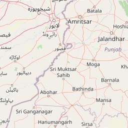
Map view of Changa Manga

Use this park location map to pinpoint Changa Manga in Pakistan, understand its exact geographic position, and read its mapped placement within the surrounding landscape more clearly.

Pigeon | © OpenStreetMap contributors

Location context for Changa Manga

Punjab

Examine the terrain, plantation canopy, and protected wildlife habitats across the Punjab plains.

Changa Manga Photos and Landscape Scenery Visual Explorer

Visual documentation captures the dense timber canopy, structured irrigation corridors, and wildlife conservation zones of Changa Manga. Detailed photography reveals the unique topography and ecological character of this historic man-made forest.

A smooth asphalt road curves through a dense, tall forest of mature trees in Changa Manga.

Park atlas

Compare nearby reserves, forest plantations, and regional wildlife habitats.

Explore Protected Areas and Parks Near Changa Manga in the Punjab Plains

Browse other protected areas and regional reserves located across the surrounding Punjab plains. Comparing adjacent park geography provides broader context for understanding man-made forest ecosystems and wildlife conservation zones.
Wildlife reservePunjab
About 93 km away#1 closest

East

Beas Conservation Reserve: Geographic Atlas of a Punjab Protected Wildlife Landscape

Braided River Systems and Freshwater Biodiversity

Located in northwestern India, the Beas Conservation Reserve protects a vital 185 km river corridor. The reserve is characterized by a complex, shifting mosaic of sand bars and islands that support rare freshwater species. This entry provides detailed insight into the protected boundaries, hydrological features, and regional geography of this unique wetland conservation area in Punjab.

Established
2017
Relief
Lowland
Scope
Terrestrial
Water
Water-dominated
Wildlife reservePunjab
About 139 km away#2 closest

East

Kanjli Wetland Wildlife Reserve: Punjab Regional Geography and Protected Area Atlas

Hydrological boundaries and wetland ecosystems of central Punjab

Kanjli Wetland functions as a critical freshwater habitat and irrigation reservoir within the Punjab river basin. This protected area supports a diverse array of aquatic and terrestrial life, offering a unique window into the intersection of historical royal infrastructure and modern conservation efforts. Use this detailed geographic profile to understand the wetland's physical landscape, its role within the Beas basin, and its status as a key component of the regional protected network.

Area
4.9 km²
Established
1870
Relief
Lowland
Climate
Subtropical
Wildlife reserveSialkot District
About 186 km away#3 closest

North

Bajwat Wildlife Sanctuary: Protected Riverine Terrain in the Sialkot District of Pakistan

Mapping riparian ecosystems along the Chenab River

Spanning approximately 5,400 hectares, Bajwat Wildlife Sanctuary provides a critical refuge for waterfowl and mammals within the densely populated Sialkot District. This protected area features a unique riverine mosaic of mudflats, open water, and floodplain forests that shift with the seasonal flows of the Chenab River and its tributaries, offering a distinct study in riparian conservation.

Area
54 km²
Relief
Lowland
Access
Access unknown
Scope
Terrestrial
National parkPunjab
About 192 km away#4 closest

North

Pabbi and Rasul Reserve Forest National Park: Punjab's Protected Landscape and Regional Geography

Subtropical thorn scrub, undulating hills, and wetland habitats.

Pabbi and Rasul Reserve Forest National Park, situated in Punjab, Pakistan, is a significant protected area renowned for its subtropical thorn scrub vegetation and its role in conserving the Pothohar Plateau's biodiversity. The park's landscape features a diverse mosaic of undulating hills, scrub-covered ridges, grasslands, and wetlands, situated within the dry tropical environments characteristic of northern Punjab. Its recent designation as a national park highlights its importance for regional conservation efforts, offering a unique glimpse into the mapped geography and protected natural landscapes of the region.

Area
147.2 km²
Established
2023
IUCN
II
Relief
Upland
National parkJhelum District
About 200 km away#5 closest

North

Tilla Reserve National Park: Mapped Protected Landscape and Dry Forest Ecosystem

Explore the geography and ancient heritage of this Salt Range national park.

Tilla Reserve National Park is a protected area recognized for its significant dry subtropical forest ecosystems and rich cultural history within Pakistan's Salt Range. Situated in Jhelum District, the park's landscape is characterized by steep, rocky ridges and ancient geological formations. Discover its unique mapped terrain, the distribution of its remnant forest habitats, and its importance as a protected natural and spiritual site.

Area
40.6 km²
Established
2021
IUCN
II
Relief
Mountain
National parkPakistan
About 205 km away#6 closest

North

Deva Vatala National Park: Pakistan's Protected Tropical Thorn Forest Landscape

Explore mapped boundaries and regional geography within the Lower Himalayan foothills.

Deva Vatala National Park is a significant protected area located in Pakistan's Lower Himalayan Range, notable for its unique tropical thorn forest ecosystem. Occupying hilly terrain with elevations up to 1,101 meters, the park's landscape is defined by semiarid conditions and acacia-dominated vegetation, creating an unusual ecological interface. Its mapped boundaries encompass lake systems and diverse habitats, making it a critical conservation site within South Asia, distinct from typical Himalayan protected areas.

Area
70 km²
Established
1998
IUCN
II
Relief
Mountain
National parkPakistan
About 209 km away#7 closest

Northwest

Salt Range National Park: Pakistan's Protected Landscape for Geographic Atlas Exploration

Mapped boundaries and regional terrain context for a Pakistani national park.

Gain insight into Salt Range National Park, a significant national park established within Pakistan. This entry focuses on its role as a protected landscape, providing a mapped view of its geographic scope and environmental context. Understand how this park contributes to Pakistan's broader geography and offers opportunities for atlas-based discovery of its natural terrain.

Relief
Mountain
Scope
Terrestrial
Wildlife reserveIndia
About 211 km away#8 closest

Northeast

Surinsar-Mansar Lakes Wildlife Reserve: Protected Landscapes and Geography in India

Paired wetland ecosystems within the Jammu foothills.

Surinsar-Mansar Lakes, a designated wildlife reserve, provides a unique geographic study of paired wetland basins set in the low-lying hills of Jammu. This protected area supports a variety of migratory waterfowl and native turtle species within its forested borders, bridging the landscape between agricultural lowlands and the sub-Himalayan foothill environment.

Area
0.59 km²
Water
Water-dominated

Common questions about visiting, size, designation, and location context for Changa Manga

Changa Manga FAQs for park facts, access, geography, and protected area context

Find quick answers about Changa Manga, including protected-area facts, park geography, trail and visitor context, and how the park fits into its surrounding country and regional landscape.
MoriAtlas Explorer

Continue Your Protected Areas Search Across the Global Atlas

Deepen your exploration by continuing the structured search for national parks and protected areas worldwide. Utilize the comprehensive filtering capabilities to compare different conservation landscapes and refine your understanding of global park geography. Discover more about the distribution and characteristics of protected natural areas.

Global natural geography