
Cliffs
Park geography
Detailed survey of regional boundaries, forest landscapes, and natural physical features.
Cheile Bicazului-Hășmaș National Park Geographic Profile, Mapping and Mountain Terrain Data
Examine the structured geography of Cheile Bicazului-Hășmaș National Park within Harghita and Neamț counties of Romania. This profile provides data on its 65.75 square kilometer protected territory, mapping significant mountain peaks, canyons, karst systems, and forest habitats.
Dramatic limestone gorges and karst landscapes in Romania's Eastern Carpathians
Cheile Bicazului-Hășmaș National Park
Cheile Bicazului-Hășmaș National Park is a protected area in northeastern Romania, spanning the border between Neamț and Harghita counties within the Eastern Carpathians mountain chain. The park encompasses the spectacular Bicaz Canyon, one of Romania's most impressive gorges, where the Bicaz River has carved a deep passage through towering limestone and conglomerate walls. Also within the park lies Lacu Roșu (Red Lake), a striking natural dam lake formed by a landslide, set against the backdrop of the Hășmaș Mountains with their distinctive rounded limestone ridges. The park covers 6,575 hectares and is divided between a special conservation zone comprising 78% of the territory and a protection zone covering the remaining 22%. The area is notable for its exceptional geological diversity, complex karst formations, and dramatic mountain scenery.
- Location
- Romania
- Park type
- National park
- Area
- 65.8 km²
Location overview
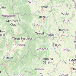
Regional placement across Harghita County and Neamț County
Geographic Mapping of Cheile Bicazului-Hășmaș National Park in Romania
Cheile Bicazului-Hășmaș National Park lies within Romania, spanning the regional limits of Harghita County and Neamț County. Atlas records detail its inland, terrestrial status across these administrative jurisdictions.
- Countries
- Romania
- Regions
- Harghita County, Neamț County
- Primary location
- Romania
- Geographic setting
- Inland
Boundary and coordinates
Mapping the 65.75 square kilometer extent and spatial coordinate limits
Geographic Boundary Map for Cheile Bicazului-Hășmaș National Park
The mapped outline of Cheile Bicazului-Hășmaș National Park provides spatial context for the protected terrain. Regional data details the 65.75 square kilometer area alongside coordinate limits and geographic spans.
- Boundary area
- 76.4 km²
- Boundary perimeter
- 134 km
- Northernmost point
- 46.8311° N
- Southernmost point
- 46.6502° N
- Easternmost point
- 25.8655° E
- Westernmost point
- 25.7332° E
- Geographic centre
- 46.7488° N, 25.811° E
- North–south span
- 20.1 km
- East–west span
- 10.1 km
Terrain and natural features
Mountain relief classifications and recorded natural formations
Cheile Bicazului-Hășmaș National Park Terrain and Named Features
Stored mountain relief classifications define the protected landscape geography of Cheile Bicazului-Hășmaș National Park. Individual feature cards list recorded names, types, and spatial relationships within the territory.
Selected named natural features
Mountain saddles
Curmătura Mieilor
1,665 m
Peaks
Făgetul Ciucului
1,264 m
Peaks
Suhardu Mare
1,507 m
Cliffs
Peretele Sudic al Pietrei Surducului
Cliffs
Cheile Bicazului
Environmental setting
Interpreting mountain relief, canyon topography, and forest distribution
Environmental Setting and Habitat Classifications in Cheile Bicazului-Hășmaș National Park
Recorded landscape features and habitat types provide structured categories for reading the physical setting of Cheile Bicazului-Hășmaș National Park. Stored classifications connect recorded environmental types to relevant atlas destinations across the protected terrain.
- Relief
- Mountain
- Water
- Minor water
- Forest cover
- Mostly forested
Landscape features
Mountains · Canyon · Forest · Rivers · Waterfalls · Cliffs · Karst · Cave
Habitat types
Temperate coniferous forest · Temperate broadleaf forest · Montane forest · Alpine meadow · Karst habitat
Park atlas
Map and compare protected landscapes throughout the Eastern Carpathians, revealing diverse gorges, karst systems, and mountain park geography.
Discover More National Parks and Protected Areas Near Cheile Bicazului-Hășmaș National Park
Explore other national parks and protected areas within the Eastern Carpathians region, expanding discovery beyond the dramatic gorges and karst landscapes of Cheile Bicazului-Hășmaș National Park. Compare their diverse geological formations, mountain scenery, and conservation efforts to trace the broader geographic context of Romania's protected landscapes.
Protected landscapeNeamț County
About 45 km away#1 closest
Northeast

Vânători-Neamț Natural Park: Protected Landscape within Neamț County, Romania
Mapped protected area and regional landscape context.
Vânători-Neamț Natural Park is a designated protected landscape located in Romania's Neamț County. This MoriAtlas entry provides detailed geographic information, focusing on the park's mapped boundaries and its role within the regional atlas of protected natural areas. Understand the park's specific landscape context and its place within the wider geography of Western Moldavia, essential for any structured exploration of Romanian protected lands.
- Area
- 306.31 km²
- Established
- 2003
- IUCN
- V
- Scope
- Terrestrial
Protected landscapeMureș County
About 52 km away#2 closest
West
Defileul Mureșului Superior Natural Park: Protected Landscape Mapping and Geography
Explore Mureș County's premier protected landscape.
Access detailed mapping and geographic context for Defileul Mureșului Superior Natural Park. As a protected landscape situated in Romania's Mureș County, this entity offers crucial insights into regional natural terrain and protected area distribution. Explore its mapped boundaries and understand its significance within the broader atlas of protected lands.
- Area
- 91.56 km²
- Established
- 2007
- IUCN
- V
- Relief
- Mixed relief
National parkRomania
About 55 km away#3 closest
Northwest
Călimani National Park: Romania's Premier National Park Protected Landscape
Explore mapped boundaries and regional geographic context.
Uncover the geographic identity of Călimani National Park, a designated national park in Romania. This resource offers detailed insights into its protected landscape, mapped terrain, and surrounding natural context. Navigate through its specific park boundaries and understand how it fits into the wider regional geography, providing a clear atlas-style overview for dedicated discovery.
- Area
- 240.41 km²
- Established
- 2000
- IUCN
- II
- Relief
- Mountain
Protected landscapeVrancea County
About 95 km away#4 closest
Southeast
Putna-Vrancea Natural Park: A Protected Landscape in Vrancea County's Carpathian Mountains
Explore mapped terrain, natural park boundaries, and regional geography.
Putna-Vrancea Natural Park, designated as a protected landscape, offers detailed geographic insights into the Vrancea Mountains in Romania. Users can explore the park's mapped terrain, understand its protected boundaries, and contextualize its natural park status within Vrancea County and the broader Eastern Carpathians region. This atlas-focused view highlights the unique landscape features and regional geographic significance of this Romanian protected area.
- Area
- 302.04 km²
- Established
- 2005
- IUCN
- V
- Relief
- Mountain
National parkRomania
About 111 km away#5 closest
Northwest
Rodna Mountains National Park: Explore Protected Landscape and Geographic Atlas
Discover the mapped terrain and protected area context.
Rodna Mountains National Park represents a key protected landscape within Romania, offering rich opportunities for geographic discovery. This page provides detailed insight into its mapped boundaries and how it integrates into the regional terrain. Delve into the structured atlas data to understand the park's protected area status and its significance within the natural geography.
- IUCN
- II
- Relief
- Mountain
- Scope
- Terrestrial
National parkRomania
127 km away#6 closest
South
Piatra Craiului National Park: Protected Landscape Atlas and Geographic Context
Explore Romania's unique national park and its mapped terrain.
Navigate the protected geography of Piatra Craiului National Park, a key national park entity. This page details its mapped boundaries and situates its natural landscape within Romania's regional geography, offering a structured point of discovery for geographic atlas enthusiasts. Understand the park's identity as a protected natural area and its contribution to the mapped terrain of the region.
- Area
- 147.66 km²
- Established
- 2000
- IUCN
- II
- Relief
- Mountain
Protected landscapeMaramureș County
About 139 km away#7 closest
Northwest
Maramureș Mountains Natural Park: Protected Landscape and Carpathian Geography
Explore the mapped boundaries and dramatic terrain of Romania's largest nature park.
Delve into the Maramureș Mountains Natural Park, a protected landscape covering extensive tracts of the northern Carpathian Mountains. This page provides detailed geographic context, showcasing the park's mapped boundaries, diverse alpine terrain, and its role within the broader regional geography of Maramureș County. Understand the natural features and protected area significance of this expansive Carpathian wilderness for structured atlas exploration.
- Area
- 1,488.5 km²
- Established
- 2004
- IUCN
- V
- Relief
- Mountain
National parkChernivtsi Oblast
About 140 km away#8 closest
North

Cheremosh National Nature Park: Protected Landscape and Geographic Context in UA
Explore mapped boundaries within Chernivtsi Oblast
Cheremosh National Nature Park represents a vital protected area within Ukraine's Chernivtsi Oblast. This entry offers a structured exploration of the park's geographic identity, focusing on its mapped boundaries and its significance as part of the regional natural landscape. Delve into the terrain and understand how Cheremosh National Nature Park contributes to the mapped geography of western Ukraine, providing a foundation for atlas-based discovery.
- Area
- 71 km²
- Established
- 2009
- IUCN
- II
- Relief
- Mountain
MoriAtlas Explorer
Continue Exploring Cheile Bicazului-Hășmaș National Park's Geographic and Protected Landscape Atlas
Further your exploration of Cheile Bicazului-Hășmaș National Park by delving into its specific geographic features and protected landscape context. Understanding the mapped boundaries and regional setting of this national park is crucial for a comprehensive view within the MoriAtlas geographic discovery platform. Discover the unique terrain and conservation significance that defines this protected area.
Browse next
Global natural geography
Explore related park routes
Explore MoriAtlas Global ParksBrowse All MoriAtlas ParksGlobal Park Map DiscoveryMoriAtlas: Browse All CountriesBrowse All MoriAtlas ContinentsNational Park Environment AtlasGrand Canyon National Park AtlasYellowstone National Park AtlasYosemite National Park Atlas and GeographySerengeti National Park AtlasGalápagos National Park Protected LandscapeBanff National Park Geography and AtlasKruger National Park Atlas EntryUluṟu-Kata Tjuṯa National Park AtlasExplore Uluru-Kata Tjuta National Park GeographyPlitvice Lakes National Park AtlasFiordland National Park Protected LandscapeGreat Smoky Mountains National Park AtlasAfghanistan National Parks and Protected AreasAlbania National Parks and Protected AreasAlgeria National Parks and Protected AreasAmerican Samoa National Parks and Protected AreasAndorra National Parks and Protected AreasAngola National Parks and Protected AreasAntarctica National Parks and Protected AreasAntigua and Barbuda Park List