Mori Atlas logo
Nature reserveChiradzulu Mountain Forest Reserve

A prominent mountain massif in southern Malawi defined by distinctive slopes and reforestation efforts

Chiradzulu Mountain Forest Reserve in the Shire Highlands: Protected Landscape and Regional Geography

Chiradzulu Mountain Forest Reserve represents a significant protected area within the Shire Highlands of southern Malawi. This massif, rising prominently from the surrounding plains, serves as a crucial natural landmark that defines the regional geography of Chiradzulu District. The reserve showcases a landscape of steep slopes, rock outcrops, and regenerating native woodland that continues to be a focal point for environmental restoration.

forest reservehighland mountainShire Highlandssouthern Malawireforestationcommunity conservation

Chiradzulu Mountain Forest Reserve

Nature reserve

Park overview

Structured park overview, official facts, and landscape profile for Chiradzulu Mountain Forest Reserve

Chiradzulu Mountain Forest Reserve park facts, protected area profile, and essential visitor context

Review the core facts for Chiradzulu Mountain Forest Reserve, including designation, size, terrain, visitor scale, habitats, and operating context in one park-focused overview.

About Chiradzulu Mountain Forest Reserve

Chiradzulu Mountain Forest Reserve sits in the Shire Highlands of southern Malawi, not far from the country's commercial heart of Blantyre. The reserve protects part of a mountain that has shaped both the geography and the identity of its surrounding district. Chiradzulu District takes its name directly from the peak, and the mountain itself acts as a local landmark visible from many vantage points along the route between Blantyre and Zomba.

The mountain has two main summits. The higher one is simply called Chiradzulu, while the lower southern peak, closer to the Blantyre to Zomba road, is known as Lisawo. Between the two peaks lies a plateau-like area where a winding road passes, and where a former British colonial administrative settlement once stood, complete with offices, staff housing, and a tourist information centre. This central ground gives the reserve a layered human history that overlays the natural landscape.

The reserve is one of the older formally established protected areas in southern Malawi, dating back to 1924. Although the mountain once supported a wide range of wildlife, including large predators and several species of antelope, decades of charcoal production and growing local populations have reduced both forest cover and animal presence. Recognising this decline, communities around the mountain have begun planting trees and organising fire patrols, particularly around settlements such as Dokotala and Nkupu. These efforts are turning parts of the reserve into one of the more visible examples of community-driven restoration in the Shire Highlands.

Quick facts and research context for Chiradzulu Mountain Forest Reserve

Chiradzulu Mountain Forest Reserve is a protected area in the Shire Highlands of southern Malawi, located roughly 20 kilometres north-east of Blantyre. The reserve was established in 1924 and covers about 774 hectares on and around the mountain. Chiradzulu reaches 1,773 metres in elevation, making it the third highest peak in southern Malawi after Mulanje and Zomba. The mountain takes its name from a Nyanja-language phrase meaning 'Yesterday's Tail', drawn from local hunting folklore. The highest peak is sometimes called Chiradzulu, while the southern peak visible from the Blantyre to Zomba road is known as Lisawo.

Protection and recognition

Examine the terrestrial protection scope and documented conservation framework

Chiradzulu Mountain Forest Reserve Protection Status and Governance Data

Chiradzulu Mountain Forest Reserve maintains a designated terrestrial protection scope within its regional conservation boundary. Records outline the established management framework and official status details associated with this protected landscape.

Protection details

Protection scope
Terrestrial
Park context

Deeper park guide and search-rich context for Chiradzulu Mountain Forest Reserve

Chiradzulu Mountain Forest Reserve history, landscape, wildlife, and travel context

Explore Chiradzulu Mountain Forest Reserve through its history, landscape character, ecosystems, wildlife, conservation priorities, cultural context, and seasonal travel timing in a structured park guide built for atlas discovery and search intent.

Why Chiradzulu Mountain Forest Reserve stands out

Chiradzulu Mountain Forest Reserve is best known for the dramatic shape of its main massif, which from the south resembles a giant reclining figure. Travellers have nicknamed the mountain 'Man Mountain' for this distinctive silhouette, and it forms a striking visual landmark along the Blantyre to Zomba road. Beyond its visual identity, the reserve is also known for its place in southern Malawian geography and folklore. It is the namesake of the surrounding administrative district, and the origin of its name is tied to a story about hunters, a leopard's tail, and the vanishing forests that once covered the peak. The reserve itself is recognised as one of the older state-managed forest areas in the Shire Highlands, and it remains an important reference point for understanding the region's natural and cultural landscape.

Chiradzulu Mountain Forest Reserve history and protected-area timeline

Chiradzulu Mountain Forest Reserve was formally established in 1924 under British colonial administration, making it one of the older forest reserves in southern Malawi. The reserve covers about 774 hectares on and around the mountain, including parts of the two main peaks and the plateau between them.

During the colonial period, the central plateau between the Chiradzulu and Lisawo peaks was developed with administrative offices, staff accommodation, and a tourist information centre. This settlement served as a working hub for forest management and gave the reserve a long-standing association with the Forestry Department and its on-the-ground rangers.

In the decades after independence, the mountain's forests came under increasing pressure as Blantyre's growing population relied on the woodlands for charcoal. Tree cover shrank, wildlife populations fell, and some species, particularly large cats, disappeared or became extremely rare. In 2024, residents of the Dokotala and Nkupu settlements launched a grassroots reforestation effort, planting trees and setting up a volunteer fire response network to protect recovering woodland. This community initiative now forms a significant part of the reserve's more recent conservation history, and the restored wooded patches honour the site's older history as a place where people who died from leprosy were laid to rest.

Chiradzulu Mountain Forest Reserve landscape and geographic character

Chiradzulu Mountain rises abruptly from the Shire Highlands plains, dominating the skyline to the east of the Blantyre to Zomba road. Its southern silhouette has a striking, almost human shape, with the peak forming a head-like profile and the lower slopes giving the impression of a heavy, seated figure. Travellers approaching from the south first glimpse the mountain near Mapanga, watch it grow larger as they reach Njuli, and see it silhouette again from the Namadzi area near the Zomba District border.

Chiradzulu Mountain Forest Reserve ecosystems, habitats, and plant life

The mountain's natural character is shaped by steep slopes, exposed rock outcrops shaped by faulting and wind erosion, and a flat central plateau between the Chiradzulu and Lisawo peaks. Geomorphology suggests that millennia of tectonic activity and weathering are responsible for the mountain's distinctive curved profile, rather than any single dramatic event.

Vegetation on the mountain has been heavily modified over time. Original forest cover was once rich enough to support large predators and a variety of herbivores, but clearance for charcoal reduced much of it. Recent replanting around Dokotala and Nkupu has introduced new wooded patches, and the reserve now contains a mosaic of recovering forest, older regrowth, and open slopes.

Chiradzulu Mountain Forest Reserve wildlife and species highlights

Chiradzulu Mountain historically supported a diverse community of mammals. Historical accounts describe lions, hyenas, foxes, jackals, baboons, monkeys, antelope, wild pigs, and leopards as part of the mountain's fauna. Local legend even ties the leopard directly to the origin story of the mountain's name.

Today, many of these species have become rare or have disappeared from the reserve. Large predators in particular have declined because of habitat loss, hunting pressure, and the spread of settlements around the lower slopes. Smaller and more adaptable species, including monkeys and baboons, are more likely to remain visible to visitors. The community restoration work around the upper slopes is partly intended to rebuild habitat that could once again support a broader range of wildlife.

Chiradzulu Mountain Forest Reserve conservation status and protection priorities

The reserve matters from a conservation perspective because it protects one of the few remnants of native woodland in a region that has lost much of its natural forest cover. The Shire Highlands around Blantyre have been heavily impacted by charcoal production, agriculture, and expanding settlements, and Chiradzulu offers a relatively concentrated area where habitat recovery can still succeed.

Top sights and standout views in Chiradzulu Mountain Forest Reserve

A working summary field could be used as a tag for related park pages, but Chiradzulu Mountain Forest Reserve's real highlights are its long-established protected status, its dramatic shape on the Shire Highlands skyline, and the grassroots reforestation work that is restoring part of its forest cover.
Monthly climate preview

Long-term representative monthly temperature and precipitation data for Chiradzulu District

Chiradzulu Mountain Forest Reserve Climate Normals and Annual Weather Patterns

Representative coordinate measurements reveal the annual temperature and precipitation rhythm across Chiradzulu Mountain Forest Reserve from 1991 to 2020. Examining the complete twelve-month profile provides deeper insight into long-term climate normals and regional weather variations.
Annual mean23 °C
18 °C27 °C
Jan24°
Feb24°
Mar23°
Apr22°
May20°
Jun19°
Jul18°
Aug21°
Sep24°
Oct27°
Nov27°
Dec25°
Warmest month
November

27.5 °C

Coolest month
July

18.3 °C

Wettest month
January

9.7 mm/day

Driest month
August

0.2 mm/day

Park location guide

Geography guide, regional context, and park location map for Chiradzulu Mountain Forest Reserve

Chiradzulu Mountain Forest Reserve park geography, regions, and map view in Malawi

Understand where Chiradzulu Mountain Forest Reserve sits in Malawi through a broader geographic reading of the surrounding landscape, nearby location context, and its mapped position within the national park landscape.

How Chiradzulu Mountain Forest Reserve fits into Malawi

Malawi is a landlocked country in Southeastern Africa. Formerly known as Nyasaland under British colonial rule, it gained independence in 1964 and became a multi-party democracy in 1994. The country is known for Lake Malawi, which comprises about one-fifth of its territory, and is governed as a unitary presidential republic with Lilongwe as its capital.

Wider geography shaping Chiradzulu Mountain Forest Reserve in Malawi

Malawi is located in Southeastern Africa within the Great Rift Valley. It is bordered by Zambia to the west, Tanzania to the north and northeast, and Mozambique to the east, south, and southwest. The country features highlands and plateaus in the northern and central areas, with the Great Rift Valley system running through the territory.

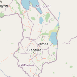
Map view of Chiradzulu Mountain Forest Reserve

Use this park location map to pinpoint Chiradzulu Mountain Forest Reserve in Malawi, understand its exact geographic position, and read its mapped placement within the surrounding landscape more clearly.

Pigeon | © OpenStreetMap contributors

Location context for Chiradzulu Mountain Forest Reserve

Chiradzulu District
Park atlas

Compare regional highland landscapes and connected conservation areas across southern Malawi.

Explore Protected Areas and Parks Near Chiradzulu Mountain Forest Reserve

Browse nearby protected landscapes and forest reserves located throughout the Shire Highlands surrounding Chiradzulu Mountain Forest Reserve. Comparing adjacent mountain terrain provides deeper geographic context for regional conservation and highland ecology.
Nature reserveMalawi
About 42 km away#1 closest

North

Zomba Plateau Nature Reserve: Geographic Overview and Mapped Mountain Terrain

Protected montane landscapes in southern Malawi

Zomba Plateau stands as a significant granitic intrusion within the Shire Highlands, featuring high-altitude terrain and diverse forested patches. This record provides essential geographic context on its geological structure, forest reserves, and surrounding vistas across the southern Malawi landscape.

Area
130 km²
Established
1913
Relief
Mountain
Climate
Tropical
Digital illustration of a large mountain range with jagged peaks, rolling green foothills, a central valley, and a stylized sun in a soft pastel sky.
Nature reserveMalawi
About 49 km away#2 closest

Southeast

Mulanje Mountain Forest Reserve: Protected Afromontane Landscapes in Southern Malawi

Geographic overview of the Mulanje Massif and its high-elevation plateau

This nature reserve covers an isolated mountain block in Malawi, rising sharply to 3,002 meters at Sapitwa Peak. The landscape features rugged granite cliffs, deeply carved valleys, and extensive Afromontane forests that provide sanctuary for numerous endemic species. Use this atlas resource to understand the massif's vertical relief, plateau characteristics, and its central role in the regional geography of southeastern Africa.

Area
563.17 km²
Established
1927
Relief
Mountain
Climate
Tropical
Wildlife reserveMalawi
About 55 km away#3 closest

Southwest

Majete Wildlife Reserve: Geographic Atlas and Protected Area Map of Southern Malawi

Savanna landscapes and Shire River valley ecology

Majete Wildlife Reserve represents a premier example of habitat restoration in the Shire River valley. Spanning 700 square kilometers of varied terrain, the reserve protects a mosaic of riparian forest and savanna that has been carefully managed to sustain Big Five wildlife. Gain insight into the regional geography, protected landscape boundaries, and conservation history of this essential Malawian wildlife sanctuary.

Area
700 km²
Established
1955
IUCN
IV
Visitors
7K annual
A watercolor painting showing a wide, panoramic view of a lake shore with marshy green grasses in the foreground and soft purple hills in the background.
Protected areaZomba District
About 70 km away#4 closest

Northeast

Lake Chilwa Protected Area: Geography, Map, and Seasonal Wetland Landscape Analysis

Understanding the endorheic basin and floodplain dynamics in Malawi.

Lake Chilwa stands as a significant protected area and Ramsar wetland in Zomba District. This detail covers its unique closed-basin geography, the influence of seasonal rainfall on surface extent, and the distinct characteristics of its shallow open water and flooded grasslands. Explore the intersection of river inflows and basin drainage that defines this critical ecosystem.

Established
1996
Relief
Lowland
Scope
Terrestrial
Water
Water-dominated
National parkMalawi
About 79 km away#5 closest

Southwest

Lengwe National Park: Malawi's Protected Landscape Atlas and Geographic Context

Mapped natural terrain and protected area boundaries in Malawi.

Lengwe National Park offers a focused look into Malawi's protected natural areas. As a designated national park, its geographic significance is highlighted through mapped boundaries and an understanding of the surrounding regional terrain. This entry provides essential context for exploring its identity as a protected landscape within southeastern Africa, contributing to a broader atlas of conservation areas.

Area
887 km²
Established
1970
IUCN
II
Climate
Tropical
National parkSouthern Region
About 95 km away#6 closest

North

Liwonde National Park: National Park in Malawi's Southern Region

Mapped Protected Area Boundaries and Geographic Context

Liwonde National Park is a designated national park situated in Malawi's Southern Region. This entry provides detailed geographic information, focusing on the park's mapped boundaries and its role within the broader atlas of protected landscapes. Explore the unique regional geography and conservation context that defines this protected area.

Area
548 km²
Established
1973
Relief
Upland
Climate
Tropical
Wildlife reserveNsanje District
About 111 km away#7 closest

South

Mwabvi Wildlife Reserve: Mapping the Protected Landscapes of the Nsanje District

Geography, woodland terrain, and regional biodiversity.

Located in the southernmost Nsanje District of Malawi, Mwabvi Wildlife Reserve encompasses a unique convergence of dry Brachystegia woodland, sandstone hills, and open savanna grasslands. This protected area offers a deep look into the varied topographies of the Lower Shire region, providing a comprehensive understanding of the reserve's historic ecological importance and its current role in regional conservation.

Area
135 km²
Established
1953
IUCN
IV
Relief
Upland
National parkMalawi
About 158 km away#8 closest

North

Lake Malawi National Park: UNESCO Protected Landscape and Endemic Fish Habitat

Discover mapped terrain, island geography, and evolutionary wonders.

Lake Malawi National Park offers unparalleled insight into freshwater biodiversity and landscape dynamics within Malawi's Great Rift Valley. As a UNESCO World Heritage Site, it is celebrated for its spectacular evolutionary radiation of cichlid fish, a phenomenon studied globally. The park's protected territory includes the mountainous Nankumbu Peninsula and thirteen islands, providing a rich context for understanding the interplay between aquatic ecosystems, terrestrial terrain, and unique island geography.

Area
94 km²
Established
1980
IUCN
II
Relief
Mountain

Common questions about visiting, size, designation, and location context for Chiradzulu Mountain Forest Reserve

Chiradzulu Mountain Forest Reserve FAQs for park facts, access, geography, and protected area context

Find quick answers about Chiradzulu Mountain Forest Reserve, including protected-area facts, park geography, trail and visitor context, and how the park fits into its surrounding country and regional landscape.
MoriAtlas Explorer

Continue Your Protected Areas Search Across the Global Atlas

Deepen your exploration by continuing the structured search for national parks and protected areas worldwide. Utilize the comprehensive filtering capabilities to compare different conservation landscapes and refine your understanding of global park geography. Discover more about the distribution and characteristics of protected natural areas.

Global natural geography