

Mori Atlas logo
National parkConway National Park

Discover the mapped boundaries and regional setting of this Queensland national park.

Conway National Park: Explore Queensland's Protected Landscape and Geographic Identity

Conway National Park stands as a significant protected area within Queensland, Australia, offering a unique geographic context for exploration. As a designated national park, its protected landscape identity is crucial for understanding regional conservation efforts and the natural terrain of northeastern Australia. This page provides an atlas-style overview, detailing the park's place within Queensland's diverse geography and highlighting its importance as a mapped natural area for discovery.

Lowland Tropical RainforestQueensland National ParkCoastal Protected AreaIUCN Category IIMound-Building BirdsWetland Habitats

Conway National Park

National park

Park overview

Structured park overview, official facts, and landscape profile for Conway National Park

Conway National Park park facts, protected area profile, and essential visitor context
Review the core facts for Conway National Park, including designation, size, terrain, visitor scale, habitats, and operating context in one park-focused overview.

About Conway National Park

Conway National Park occupies the Conway Peninsula in coastal Queensland, representing one of the most significant protected areas for lowland tropical rainforest in the state. The park's establishment in 1938 reflects an early recognition of the ecological importance of this landscape, which features a relatively flat terrain averaging 44 meters in elevation. Unlike the mountainous rainforests of Tropical North Queensland, the Conway landscape represents a distinct lowland ecosystem type that has been largely cleared for agriculture and development in surrounding regions. The park provides a critical refuge for rainforest-dependent species and preserves a landscape that would otherwise be lost. Visitors to the park experience a wet, humid environment typical of lowland tropical environments, with dense vegetation creating a distinctive atmosphere different from Australia's more famous alpine or arid landscapes. The park is accessible from Proserpine, making it a destination for those exploring the Whitsunday region of Queensland.

Quick facts and research context for Conway National Park

Conway National Park is situated in Queensland, Australia, near the town of Proserpine. The park was established in 1938 and covers 225 square kilometers, making it a substantial protected area in the region. It is classified as an IUCN Category II protected area, denoting its status as a national park. The park protects the Conway Peninsula, which features the largest remaining lowland tropical rainforest in Queensland outside the Tropical North Queensland area. This rainforest ecosystem is notable for its diversity and relatively intact condition, representing a habitat type that has been significantly reduced across Australia's eastern seaboard.

Park context

Deeper park guide and search-rich context for Conway National Park

Conway National Park history, landscape, wildlife, and travel context
Explore Conway National Park through its history, landscape character, ecosystems, wildlife, conservation priorities, cultural context, and seasonal travel timing in a structured park guide built for atlas discovery and search intent.

Why Conway National Park stands out

Conway National Park is best known for preserving the largest area of lowland tropical rainforest in Queensland beyond the Tropical North Queensland region. This distinction makes the park particularly significant for conservation, as lowland tropical rainforests are a rare and diminished habitat type in Australia. The park's vegetation includes dry vine thicket, mangrove communities, paperbark woodlands, and pandanus stands, creating a complex mosaic of habitats. The area is also notable for supporting populations of mound-building birds, including the Australian brush-turkey and the orange-footed scrubfowl, which are characteristic species of Queensland's forested environments.

Conway National Park history and protected-area timeline

Conway National Park was established in 1938, placing it among the older national parks in Queensland. The establishment of the park reflected growing awareness in the early twentieth century of the need to preserve significant natural landscapes in Australia. At the time of its creation, the concept of national park protection was still relatively new in Australia, with early reserves often focused on preserving scenic landscapes or timber resources. Conway's designation recognized the scientific and ecological importance of the lowland rainforest ecosystem, which was increasingly seen as valuable for biodiversity conservation. The park has been managed by the Queensland Parks and Wildlife Service since its inception, with management focuses evolving over the decades to emphasize ecosystem conservation and visitor enjoyment.

Conway National Park landscape and geographic character

The landscape of Conway National Park is defined by its low-lying coastal topography centered on the Conway Peninsula. The terrain is remarkably flat compared to much of Queensland, with an average elevation of just 44 meters creating a gentle, sometimes marshy landscape. The peninsula extends into the Coral Sea, giving the park a coastal character despite its primary focus on rainforest protection. The low elevation and proximity to the ocean influence the local climate, creating conditions favorable to tropical rainforest development. The landscape features a mixture of permanently wet areas supporting mangroves and paperbark woodlands, alongside drier ridge and slope areas where dry vine thicket and open forests develop. This topographic and hydrological diversity creates a varied landscape within the park's boundaries.

Conway National Park ecosystems, habitats, and plant life

The natural environment of Conway National Park centers on its extensive lowland tropical rainforest, which represents the largest example of this habitat type in Queensland outside the Tropical North Queensland region. The park supports a complex mosaic of vegetation communities including dry vine thicket on ridges and slopes, mangrove communities in coastal and estuarine areas, open forests with characteristic grasstree understorey, paperbark woodlands around wetlands, and pandanus woodlands along watercourses. This vegetation diversity supports a range of ecological processes and provides habitat for numerous species. The lowland rainforest ecosystem is considered significant because similar habitats have been extensively cleared across Queensland's coastal lowlands for agriculture, urban development, and other human uses, making protected remnants like Conway increasingly valuable for biodiversity conservation.

Conway National Park wildlife and species highlights

Conway National Park is home to several notable bird species, particularly two species of mound-building birds that are characteristic of Queensland's forested landscapes. The Australian brush-turkey and the orange-footed scrubfowl are both present in the park, representing large ground-dwelling birds that play important ecological roles in rainforest ecosystems. These species are known for their distinctive breeding behavior, with males building large mounds of decaying vegetation that provide heat for incubating eggs. The diverse habitat types within the park support additional wildlife, though detailed species lists are limited in available source material. The combination of rainforest, woodland, mangrove, and wetland habitats creates conditions favorable for a range of fauna species.

Conway National Park conservation status and protection priorities

Conway National Park serves an important conservation function by protecting the largest remaining tract of lowland tropical rainforest in Queensland outside the Tropical North Queensland region. This habitat type has been significantly reduced across eastern Australia through historical land clearing, making protected areas like Conway increasingly important for maintaining biodiversity. The park preserves not only the rainforest itself but also associated ecosystems including mangroves, wetlands, and coastal woodlands that together form a diverse coastal landscape. As an IUCN Category II protected area, the park is managed primarily for ecosystem conservation while also providing opportunities for nature-based recreation and environmental education. The protection of this lowland rainforest ecosystem represents a long-term commitment to preserving Queensland's natural heritage.

Conway National Park cultural meaning and human context

The Conway Peninsula has been part of the cultural landscape of the Whitsunday region of Queensland for thousands of years, though detailed information about indigenous associations with the area is limited in available source material. The region is traditionally associated with Aboriginal peoples of the area, and the landscape would have supported indigenous communities through its rich resources of food, materials, and water. European settlement of the Proserpine area began in the nineteenth century, with the region eventually developing as an agricultural and tourism destination. The establishment of the national park in 1938 reflected a growing recognition of the value of preserving natural landscapes, a perspective that has evolved to encompass broader ecological and indigenous cultural considerations in modern park management.

Top sights and standout views in Conway National Park

The defining highlight of Conway National Park is its extensive lowland tropical rainforest, the largest example of this ecosystem type in Queensland outside the Tropical North Queensland region. Visitors can explore walking tracks ranging from easy to moderate difficulty, experiencing the dense vegetation and humid atmosphere of this rare habitat. The park offers walk-in bush camping opportunities in a remote setting, though there are no established camp sites, adding to the sense of wilderness exploration. The Beak Lookout provides elevated views over the park's landscapes. The presence of Australian brush-turkey and orange-footed scrubfowl adds wildlife interest, particularly for birdwatchers interested in Australia's unique mound-building birds.

Best time to visit Conway National Park

The best time to visit Conway National Park is during the cooler, drier months from April to October, when temperatures are more comfortable for outdoor activities and rainfall is typically lower. The tropical climate means that summer months from November to March can be hot, humid, and wet, with heavier rainfall and the potential for tropical weather systems. Visiting during the drier season provides more comfortable conditions for walking and camping, though the rainforest maintains its lush character year-round. Visitors should be prepared for humid conditions regardless of season and should consider the remote nature of the park when planning their visit.

Park location guide

Geography guide, regional context, and park location map for Conway National Park

Conway National Park park geography, regions, and map view in Australia
Understand where Conway National Park sits in Australia through a broader geographic reading of the surrounding landscape, nearby location context, and its mapped position within the national park landscape.

How Conway National Park fits into Australia

Australia is a constitutional monarchy and federal parliamentary democracy comprising six states and ten territories. With a population of nearly 28 million, it is one of the world's most urbanised countries, with most people concentrated on the eastern seaboard. The country has a high Human Development Index and is known for its cultural diversity, ancient Aboriginal heritage, and unique wildlife.

Wider geography shaping Conway National Park in Australia

Australia occupies the entire Australian continent, the island of Tasmania, and numerous smaller islands. It is the world's flattest and driest inhabited continent, featuring vast deserts in the interior (the Outback), tropical rainforests along the eastern coast, and a coastline bordering the Indian and Pacific Oceans.

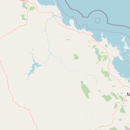
Map view of Conway National Park

Use this park location map to pinpoint Conway National Park in Australia, understand its exact geographic position, and read its mapped placement within the surrounding landscape more clearly.

Pigeon | © OpenStreetMap contributors

Location context for Conway National Park

Queensland
Park atlas

Compare adjacent protected landscapes, lowland rainforests, and coastal ecosystems across Queensland's diverse geographical spread.

Explore Nearby National Parks and Protected Areas Around Conway National Park's Queensland Coastal Landscape
Browse a curated list of national parks and protected areas situated near Conway National Park, focusing on the surrounding coastal Queensland geography and diverse conservation landscapes. Compare distinct lowland rainforests, coastal wetlands, and other unique ecosystems, providing rich regional context for broader protected-area exploration across this Australian territory.
National parkQueensland

Molle Islands National Park: Queensland National Park Atlas and Protected Landscape Identity

Mapped boundaries and regional geographic context within northeastern Australia.

Molle Islands National Park is a designated national park located in Queensland, Australia. This dedicated atlas entry provides an understanding of its protected landscape character, focusing on its mapped geographic boundaries and its position within the regional context of northeastern Australia. Explore how this protected area contributes to the broader understanding of Queensland's natural geography and conservation lands.

Area
18 km²
IUCN
II
Climate
Tropical
Access
Moderate access
National parkQueensland

Dryander National Park: Queensland's Protected Landscape and Geographic Identity

Mapped boundaries and natural terrain context in Queensland.

Delve into the protected landscape of Dryander National Park, a significant national park located in Queensland, Australia. This entry provides essential geographic context, detailing the park's boundaries and its representation within the broader regional atlas of protected areas. Understand its role as a mapped natural landscape contributing to the unique geography of Queensland, ideal for detailed exploration without travel logistics.

Area
118.82 km²
Established
1938
IUCN
II
Relief
Mountain
National parkQueensland

Whitsunday Islands National Park: Iconic Queensland National Park with Tropical Island Landscapes

Explore mapped protected boundaries and diverse coastal geography.

Whitsunday Islands National Park encompasses a remarkable collection of 74 islands off Queensland's coast, celebrated for their pristine tropical island landscapes and iconic Whitehaven Beach. This national park provides a unique opportunity to explore Australia's protected coastal and marine environments, offering detailed geographic context, mapped island topography, and insights into the park's role within the Great Barrier Reef World Heritage Area.

Area
170 km²
Established
1944
IUCN
II
Relief
Lowland
National parkQueensland

Repulse Island National Park: Queensland's Coastal Protected Area and Mapped Geography

Explore this key national park's mapped boundaries and island landscape.

Repulse Island National Park is an important protected natural area offering unique insights into coastal island geography within Queensland's expansive conservation network. Established as a national park, it signifies a commitment to preserving representative natural landscapes. This page focuses on the mapped boundaries, regional geographic context, and the protected landscape identity of Repulse Island National Park, providing a detailed entry point for atlas-driven discovery of Australia's protected areas.

Area
1.51 km²
Established
1994
IUCN
II
Scope
Terrestrial
National parkQueensland

Lindeman Islands National Park: Queensland National Park Atlas and Protected Landscape

Explore mapped boundaries and regional geography within Queensland.

Lindeman Islands National Park is a designated national park offering insights into Queensland's protected natural landscapes. This page provides an atlas-style exploration of its geographic scope, mapped terrain, and role as a protected area within the northeastern Australian region. Understand its setting and unique landscape character for informed geographic discovery.

Area
33.1 km²
IUCN
II
Relief
Lowland
Climate
Tropical
National parkQueensland

Gloucester Island National Park: A National Park within Queensland's Diverse Geography

Mapped protected area and natural landscape context.

Gloucester Island National Park represents a distinct protected landscape in Queensland, Australia. This entry focuses on its identity as a national park, providing atlas-level detail on its geographic scope and mapped boundaries. Understand how this protected area fits within the broader natural terrain and regional geography of northeastern Australia, offering a unique lens for map-based exploration and discovery.

Area
29.6 km²
Established
1994
IUCN
II
Relief
Lowland
National parkQueensland

Smith Islands National Park: Queensland Coastal Protected Area Map

Discover the mapped geography and island landscapes of North Queensland.

Smith Islands National Park represents a significant protected island landscape off the coast of Queensland, Australia. This page allows for detailed exploration of its geographic features, mapped boundaries, and role as a national park within the North Queensland region's atlas of natural areas. Understand the unique character of these tropical islands and their place within Australia's network of preserved coastal environments.

Area
18.7 km²
IUCN
II
Scope
Terrestrial
National parkQueensland

Holbourne Island National Park: Queensland Coastal Wildlife Sanctuary and Maritime Atlas Entry

Explore the mapped geography and protected landscape of this small island national park.

Holbourne Island National Park, situated off the Queensland coast, serves as a vital protected area focused on coastal wildlife conservation. This 34-hectare national park is recognized for its importance as a natural bird sanctuary and a critical nesting ground for sea turtles, offering a focused point of discovery for marine ecosystem protection. Its landscape, characterized by coastal vegetation and rock formations, also holds a unique maritime history, notably tied to the SS Gothenburg shipwreck, making it a compelling destination for understanding Australia's island protected areas and their regional geographic context within the Coral Sea.

Area
0.34 km²
Established
1982
IUCN
II
Relief
Lowland

Common questions about visiting, size, designation, and location context for Conway National Park

Conway National Park FAQs for park facts, access, geography, and protected area context
Find quick answers about Conway National Park, including protected-area facts, park geography, trail and visitor context, and how the park fits into its surrounding country and regional landscape.
MoriAtlas Explorer

Continue Your Protected Areas Search Across the Global Atlas

Deepen your exploration by continuing the structured search for national parks and protected areas worldwide. Utilize the comprehensive filtering capabilities to compare different conservation landscapes and refine your understanding of global park geography. Discover more about the distribution and characteristics of protected natural areas.

Global natural geography