
Mori Atlas logo
Wildlife reserveCoringa Wildlife Sanctuary

A vital protected wetland sanctuary in Andhra Pradesh defining India's coastal tidal geography

Coringa Wildlife Sanctuary: Mapping the Mangrove Landscapes of the Godavari Estuary Region

Coringa Wildlife Sanctuary serves as a primary protected mangrove ecosystem situated at the confluence of the Godavari and Gouthami rivers in Andhra Pradesh. This coastal landscape features an intricate network of tidal channels, backwaters, and mudflats that sustain a high concentration of mangrove flora and significant bird communities. The sanctuary provides essential habitat across its deltaic terrain, offering a clear view into the complex hydrology and coastal conservation patterns found along the eastern seaboard of India.

mangrove forestestuaryGodavari deltacoastal ecosystembirdwatchingtidal wetlands
A flat-style digital illustration featuring a wooden boardwalk and benches over a river with a waterfall and cliffs in the background.

Coringa Wildlife Sanctuary

Wildlife reserve

Park overview

Structured park overview, official facts, and landscape profile for Coringa Wildlife Sanctuary

Coringa Wildlife Sanctuary park facts, protected area profile, and essential visitor context

Review the core facts for Coringa Wildlife Sanctuary, including designation, size, terrain, visitor scale, habitats, and operating context in one park-focused overview.

About Coringa Wildlife Sanctuary

Coringa Wildlife Sanctuary is a coastal protected area located in the deltaic region of the Godavari River system in Andhra Pradesh, India. Established on July 5, 1978, and managed by the Andhra Pradesh Forest Department, the sanctuary occupies a major portion of the Godavari Estuary, where the Gouthami and Godavari rivers and their deltaic branches meet the Bay of Bengal near Kakinada. Its position within this dynamic river-mouth environment gives Coringa a character very different from inland reserves, defined instead by tides, salinity, and mangrove ecology.

The sanctuary's landscape is shaped by an intricate network of tidal waterways, including the rivers Coringa and Gaderu, which cross the region and join a broader system of deltaic channels. Approximately half of the reserve consists of backwaters, and the complex of marsh vegetation, salt flats, and tidal mudflats covers a substantial portion of the surrounding area. This hydrological complexity creates a mosaic of habitats that supports the sanctuary's unusually rich flora and fauna.

Vegetation in Coringa is dominated by mangrove forests of significant national importance, with twenty-four documented species of mangrove trees forming the core of the sanctuary's plant cover. Alongside these trees grow a layer of salt-tolerant shrubs, herbs, and grasses typical of intertidal zones, including species adapted to fluctuating salinity and waterlogged soils. Dry deciduous tropical forest elements are also present in parts of the reserve, where conditions transition from tidal flats to drier land.

The sanctuary is widely noted for its biodiversity, particularly its birdlife, which thrives on the small fish, shrimps, and mollusks exposed during low tide. More than 120 bird species have been recorded, ranging from egrets, herons, and kingfishers to waders, flamingos, and storks. Conservation interest is heightened by the presence of globally threatened species, including the critically endangered white-backed vulture and long-billed vulture, vulnerable spot-billed pelican, and near-threatened painted stork and Oriental white ibis.

Quick facts and research context for Coringa Wildlife Sanctuary

Coringa Wildlife Sanctuary sits within the Godavari Estuary in Andhra Pradesh, roughly 8 kilometers from the port city of Kakinada, along National Highway 216. It is classified as an IUCN Category IV protected area, focused on habitat and species management, and is administered by the Andhra Pradesh Forest Department. The sanctuary covers an extensive area that includes mangrove forests, dry deciduous tropical forest, backwaters, tidal channels, and an 18-kilometer sand pit used by nesting sea turtles.

The sanctuary is recognized as India's third-largest mangrove formation and is home to more than 120 bird species, along with mammals such as the smooth-coated otter, fishing cat, and golden jackal. Its estuarine setting is shaped by the Gouthami and Godavari rivers, which together create a network of deltaic branches and tidal channels that sustain the mangrove ecosystem throughout the year.

Protection and recognition

Explore documented protection status and governance details for Coringa Wildlife Sanctuary

Coringa Wildlife Sanctuary Protection Status and Conservation Data

Coringa Wildlife Sanctuary maintains a mixed protection scope with structured management parameters recorded across conservation databases. Official protection status records detail international recognition sources and designate administrative boundaries for the protected area.

Protection details

Protection scope
Mixed
Transboundary protection
No
Park context

Deeper park guide and search-rich context for Coringa Wildlife Sanctuary

Coringa Wildlife Sanctuary history, landscape, wildlife, and travel context

Explore Coringa Wildlife Sanctuary through its history, landscape character, ecosystems, wildlife, conservation priorities, cultural context, and seasonal travel timing in a structured park guide built for atlas discovery and search intent.

Why Coringa Wildlife Sanctuary stands out

Coringa Wildlife Sanctuary is best known for its expansive mangrove forests along the Godavari Estuary, which together form the third-largest mangrove stretch in India. Its tangled prop-root systems, daily tidal flooding, and backwater channels create one of the most ecologically distinctive coastal protected areas on India's eastern seaboard. The sanctuary is also widely recognized for its rich birdlife, with over 120 recorded species drawn to the rich feeding grounds exposed during low tide. The presence of critically endangered vultures, near-threatened painted storks and Oriental white ibises, vulnerable spot-billed pelicans, and a breeding population of smooth-coated otters gives Coringa significant conservation importance beyond its mangrove identity.
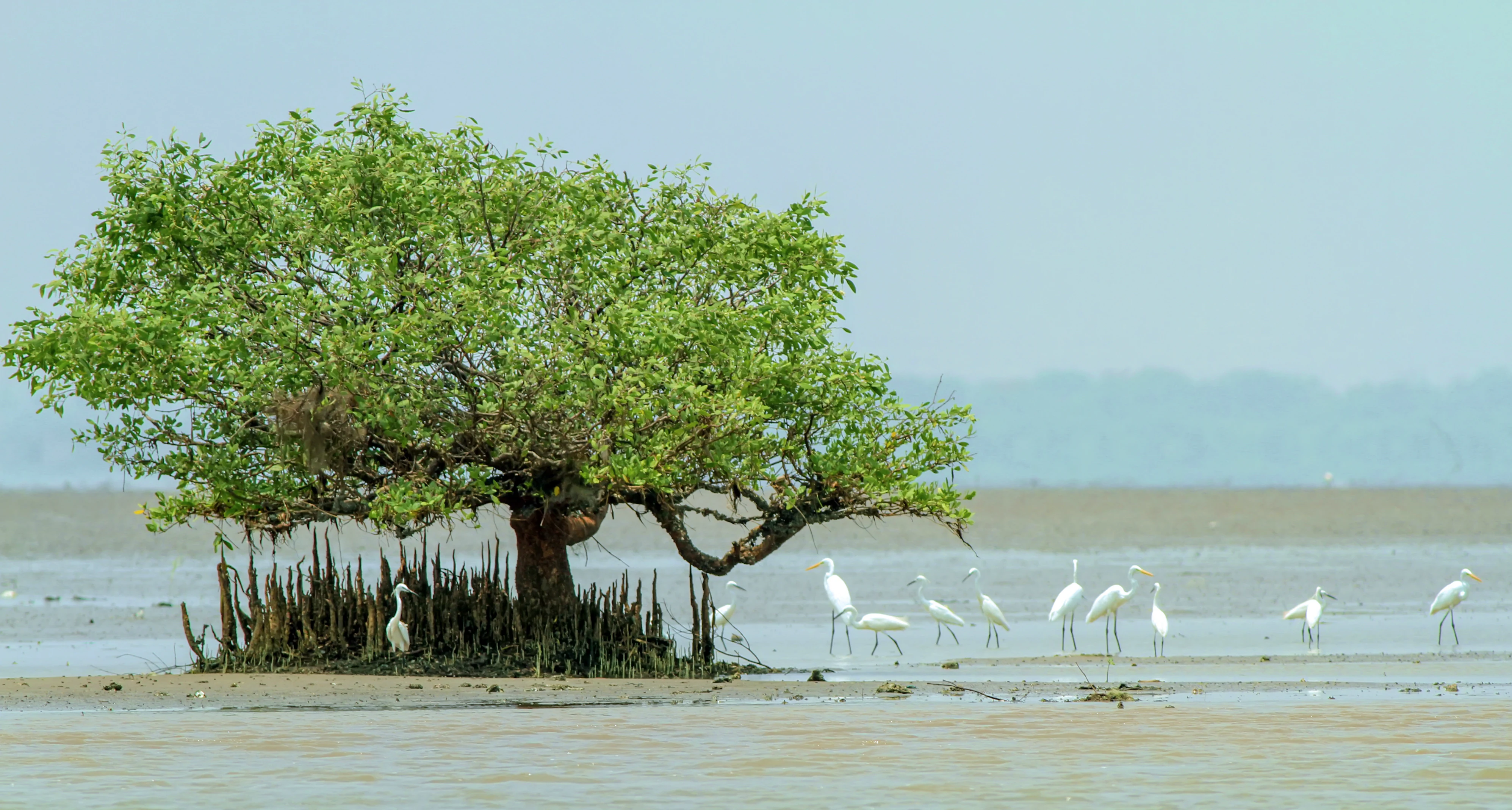
A group of white egrets stands on mudflats near a mangrove tree in an open coastal area.
Egrets foraging on the mudflats surrounding a mangrove tree in Coringa Wildlife Sanctuary.

Coringa Wildlife Sanctuary history and protected-area timeline

Coringa Wildlife Sanctuary was formally established on July 5, 1978, as a protected area under the management of the Andhra Pradesh Forest Department. Its creation reflected growing recognition of the ecological importance of the Godavari Estuary, where extensive mangrove forests and deltaic wetlands faced increasing pressure from port development, fuelwood collection, and industrial expansion around the port city of Kakinada.

During the 1970s, efforts were made to reintroduce the saltwater crocodile into the sanctuary, but these attempts did not succeed and the species has not been present within the reserve for more than three decades. Despite this setback, the sanctuary has continued to function as a refuge for mangrove-dependent wildlife and as an important breeding area for species such as the smooth-coated otter.

In recent decades, conservation attention has increasingly focused on the pressures facing the mangroves, including habitat degradation, poaching, and the encroachment of aquaculture and industrial activity. The Andhra Pradesh Forest Department, along with conservation organizations, has undertaken afforestation initiatives to restore mangrove cover and has worked to protect otter populations that have been affected by habitat loss.

Coringa Wildlife Sanctuary landscape and geographic character

The landscape of Coringa Wildlife Sanctuary is defined by the meeting of river and sea, where the Gouthami and Godavari rivers branch into a complex of deltaic channels before reaching Kakinada Bay. The sanctuary lies between roughly 16°-30' to 17°-00' N latitudes and 82°-14' to 82°-23' E longitudes, occupying an extensive area at the western edge of the Bay of Bengal. This setting gives the reserve a distinctly coastal character, shaped by daily tides, sediment deposition, and the slow accumulation of mudflats.

The rivers Coringa and Gaderu and their deltaic branches intersect the sanctuary alongside other tidal channels, creating a dense hydrological network that drains and fills with the rhythm of the tides. About half of the reserve consists of backwaters, and a substantial area of adjacent marsh vegetation has formed through ongoing sediment settlement. An 18-kilometer-long sand pit lies within the sanctuary, adding to the variety of coastal landforms present.

Vegetation patterns transition across this landscape, from dense mangrove stands in the intertidal zone to drier areas supporting dry deciduous tropical forest. The mangrove trees rise from the water on tangled prop roots, slowing tidal flow and encouraging sediment buildup, which continually reshapes the shoreline. The mean temperatures of the region range widely through the year, and rainfall exceeds 1,000 millimeters, supporting the lush tidal ecosystem that defines Coringa's visual and ecological identity.

Coringa Wildlife Sanctuary ecosystems, habitats, and plant life

Coringa Wildlife Sanctuary protects one of India's most significant estuarine ecosystems, centered on the mangrove forests of the Godavari Estuary. The sanctuary's ecological character is shaped by the constant interplay of freshwater and saltwater, with tidal channels, backwaters, and deltaic branches creating a shifting mosaic of aquatic and semi-aquatic habitats. These conditions support a distinctive community of salt-tolerant plants and animals that are adapted to fluctuating salinity and twice-daily tidal flooding.

The flora of the sanctuary includes twenty-four species of mangrove trees, alongside an associated community of shrubs, herbs, and grasses that thrive in the intertidal zone. Common mangrove genera such as Avicennia, Rhizophora, Ceriops, Bruguiera, Excoecaria, Sonneratia, and Aegiceras form the backbone of the tidal forest, while salt-tolerant species such as Suaeda, Salicornia, Sesuvium, and Porteresia occupy the marshy margins. Dry deciduous tropical forest elements are present in the upland transitions, giving the sanctuary a layered vegetation structure unusual for a coastal reserve.

The mangrove root systems, mudflats, and tidal creeks of Coringa also serve as critical nursery grounds for fish, crustaceans, and mollusks. These productive feeding areas form the foundation of the reserve's food web, supporting both resident wildlife and seasonal migrants. The ecological richness of this mangrove system has earned Coringa recognition as the third-largest stretch of mangrove forests in India, underscoring its importance at a national scale.

Coringa Wildlife Sanctuary wildlife and species highlights

Coringa Wildlife Sanctuary supports a rich community of wildlife, with birdlife being particularly prominent because of the abundant feeding opportunities provided by the mangrove backwaters. During low tide, elevated mudflats expose small fish, shrimps, and mollusks that attract a wide variety of wading and shore birds. More than 120 bird species have been recorded in the sanctuary, including egrets, herons, kingfishers, stints, sandpipers, flamingos, gulls, and pelicans.

The reserve is also significant for the presence of globally threatened bird species, including the critically endangered white-backed vulture and long-billed vulture. The painted stork, Oriental white ibis, and ferruginous pochard are recorded as near-threatened species, while the spot-billed pelican is documented as vulnerable. Large numbers of waders and mangrove-dependent bird species further enhance the ornithological value of the sanctuary, particularly along the tidal channels and mudflats that dominate its landscape.

Mammal life in Coringa is shaped by the mangrove environment and includes golden jackal, fishing cat, and a notable breeding population of smooth-coated otter. Sea turtles are also strongly associated with the reserve, especially the olive ridley sea turtle, which nests along the sanctuary's 18-kilometer sand pit between January and March each year. Although past efforts to reintroduce the saltwater crocodile did not succeed, the sanctuary remains an important refuge for the mammal and reptile species adapted to its estuarine conditions.

Coringa Wildlife Sanctuary conservation status and protection priorities

Coringa Wildlife Sanctuary holds considerable conservation significance as the protector of India's third-largest mangrove formation and as a key refuge for species that depend on the Godavari Estuary. The mangrove ecosystem within the reserve plays an important role in stabilizing the coastline, reducing erosion from storm surges, tidal currents, and wave action. The complex root systems of the mangroves also provide shelter and feeding grounds for fish, crustaceans, and other organisms that underpin the estuarine food web.

The sanctuary faces ongoing conservation challenges linked to its proximity to the port city of Kakinada and to nearby villages. Mangrove exploitation by local communities, including the harvesting of species such as Avicennia officinalis and Avicennia marina for fuelwood, has placed sustained pressure on the forest. Studies by organizations such as the Indian Bird Conservation Network have highlighted the dependence of local fishermen on mangrove resources and the resulting impact on forest health.

Otter populations within the sanctuary have been particularly affected by poaching and habitat destruction, exacerbated by increasing industrialization in the Godavari Delta, expanding aquaculture, and heavy fishing pressure. The Andhra Pradesh Forest Department has responded with conservation measures focused on otter protection and mangrove afforestation. These efforts aim to restore degraded mangrove areas and strengthen the ecological integrity of one of India's most important estuarine protected areas.

Coringa Wildlife Sanctuary cultural meaning and human context

The cultural identity of Coringa Wildlife Sanctuary is closely tied to the fishing communities and rural villages that inhabit the Kakinada coastal region and the surrounding Godavari Delta. Local livelihoods have long depended on the resources of the estuary, particularly through fishing in the mangrove channels and the harvesting of mangrove wood for fuel and daily needs. This close relationship between people and the mangrove ecosystem has shaped both the social fabric of the region and the conservation challenges facing the sanctuary.

The presence of fishing cat populations within the reserve has also become part of local identity, with sculptures and interpretive features such as the well-known 'Macha' fishing cat sculpture in the reserve reflecting community recognition of the species' place in the area's natural heritage. The sanctuary therefore functions not only as an ecological refuge but also as part of the broader cultural landscape of coastal Andhra Pradesh.

Top sights and standout views in Coringa Wildlife Sanctuary

Coringa Wildlife Sanctuary stands out as India's third-largest mangrove stretch, with twenty-four documented mangrove tree species forming the backbone of a richly layered estuarine ecosystem. Its setting along the Godavari Estuary creates a complex network of tidal creeks, backwaters, and deltaic channels that sustain both resident wildlife and seasonal visitors, making the reserve a landmark example of India's coastal mangrove heritage.

Among its most distinctive features are an 18-kilometer sand pit used annually by nesting olive ridley sea turtles, a breeding population of smooth-coated otters, and a bird community of more than 120 species that includes critically endangered vultures and vulnerable pelicans. These qualities, combined with ongoing mangrove afforestation and otter conservation initiatives, give Coringa a strong identity as both an ecological stronghold and a working example of coastal habitat protection in India.

Best time to visit Coringa Wildlife Sanctuary

The sanctuary's character shifts throughout the year depending on tidal rhythms, rainfall, and seasonal wildlife activity. Between January and March, the 18-kilometer sand pit becomes an important nesting ground for olive ridley sea turtles, drawing seasonal interest to this stretch of the reserve. The winter and early spring months also tend to bring favorable conditions for birdwatching, as cooler temperatures and clearer skies support a high diversity of resident and visiting species along the mudflats and tidal channels.

The monsoon season, with rainfall exceeding 1,000 millimeters across the year, transforms the visual character of the mangrove forests, making boat-based viewing along the tidal creeks especially atmospheric. The tidal cycle itself plays a major role in shaping the experience, since low tide exposes mudflats rich with feeding birds and marine life, while high tide immerses the mangrove roots and reveals the broader estuarine scenery. Temperatures remain warm to hot for much of the year, ranging from the high teens to around 40°C, with milder coastal conditions typically experienced during the cooler months.
Monthly climate preview

Long-term representative monthly temperature and precipitation rhythm

Coringa Wildlife Sanctuary Climate Normals and Annual Temperature Patterns

Representative coordinates record long-term monthly temperature and precipitation normals for Coringa Wildlife Sanctuary across the 1991 to 2020 climatology period. Detailed weather by month breakdowns on the complete profile route provide broader analytical context for regional temperature ranges and precipitation totals.
Annual mean28 °C
24 °C31 °C
Jan24°
Feb26°
Mar28°
Apr30°
May31°
Jun30°
Jul28°
Aug28°
Sep28°
Oct28°
Nov26°
Dec24°
Warmest month
May

30.7 °C

Coolest month
January

24.2 °C

Wettest month
October

7.4 mm/day

Driest month
January

0.3 mm/day

Park location guide

Geography guide, regional context, and park location map for Coringa Wildlife Sanctuary

Coringa Wildlife Sanctuary park geography, regions, and map view in India

Understand where Coringa Wildlife Sanctuary sits in India through a broader geographic reading of the surrounding landscape, nearby location context, and its mapped position within the national park landscape.

How Coringa Wildlife Sanctuary fits into India

India is a South Asian country bordered by the Indian Ocean, Arabian Sea, and Bay of Bengal. It shares land borders with Pakistan, China, Nepal, Bhutan, Bangladesh, and Myanmar. The country has a population of over 1.4 billion people and operates as a federal parliamentary republic with its capital in New Delhi.

Wider geography shaping Coringa Wildlife Sanctuary in India

India occupies the Indian subcontinent in South Asia, bordered by the Arabian Sea to the southwest, the Bay of Bengal to the southeast, and the Indian Ocean to the south. It shares land borders with Pakistan to the west, China, Nepal, and Bhutan to the north, and Bangladesh and Myanmar to the east. The territory also includes the Andaman and Nicobar Islands in the Indian Ocean.

Map view of Coringa Wildlife Sanctuary

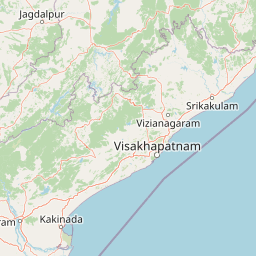
Use this park location map to pinpoint Coringa Wildlife Sanctuary in India, understand its exact geographic position, and read its mapped placement within the surrounding landscape more clearly.

Pigeon | © OpenStreetMap contributors

Location context for Coringa Wildlife Sanctuary

Andhra Pradesh

Visual exploration of tidal channels, mangrove forests, and estuarine habitats

Coringa Wildlife Sanctuary Photos, Landscapes, and Coastal Scenery

Captured views reveal the complex network of tidal creeks, prop-root forests, and coastal landforms that define the protected Godavari Estuary environment. Studying these authentic field photographs provides a clearer understanding of the botanical diversity and fragile intertidal ecosystems sustained within the reserve.

A group of white egrets stands on mudflats near a mangrove tree in an open coastal area.

A wooden boardwalk or pier extends over a river, lined with railings, benches, and lamp posts, with dense green mangrove forest on both sides.

Park atlas

Compare adjacent coastal ecosystems, estuarine habitats, and regional protected landscapes.

Exploring Other Parks Near Coringa Wildlife Sanctuary and Regional Protected Areas

Users examining Coringa Wildlife Sanctuary can browse nearby national parks and protected areas to compare coastal geography and estuarine habitats. Extending the search across the surrounding region reveals connected conservation landscapes and diverse regional wildlife formations.
National parkAndhra Pradesh
About 116 km away#1 closest

Northwest

Papikonda National Park: Andhra Pradesh National Park Protected Landscape and Map Exploration

Mapped protected area boundaries and regional geography context.

Papikonda National Park is a designated national park in Andhra Pradesh, India, serving as a crucial component of regional protected landscapes. This entry provides detailed information on its mapped boundaries and geographic positioning, essential for atlas-based exploration and understanding its natural terrain. Users can explore the specific context of Papikonda National Park within the broader geography of Andhra Pradesh through its structured park data.

Area
1,012.86 km²
Established
1978
IUCN
II
Relief
Upland
Wildlife reserveAndhra Pradesh
About 124 km away#2 closest

West

Kolleru Bird Sanctuary Wildlife Reserve: Protected Wetland and Basin Geography Atlas

Mapped freshwater wetlands in Andhra Pradesh

Kolleru Bird Sanctuary represents an essential protected freshwater basin situated in the deltaic plains of Andhra Pradesh. The area supports a dynamic habitat of open water and reedbed environments that transition through the seasons. This record provides a clear geographic view of the sanctuary, highlighting its role as a key Ramsar-recognized wetland within the regional landscape context.

Area
673 km²
Established
1999
IUCN
IV
Relief
Lowland
A horizontal watercolor painting depicting a landscape with a foreground pond, rolling hills covered in sparse forest, and distant purple-toned mountains under a white sky.
Wildlife reserveAndhra Pradesh
About 151 km away#3 closest

Northeast

Kambalakonda Wildlife Sanctuary: Mapped Geography and Protected Forest Landscapes

A diverse wildlife reserve in the Eastern Ghats foothills of Andhra Pradesh.

Kambalakonda Wildlife Sanctuary protects an essential patch of East Deccan dry evergreen forest near Visakhapatnam. The hilly topography and varied scrub-meadow ecosystems offer a distinct look at the region's biodiversity within the Eastern Ghats, serving as a primary site for conservation education and ecological study in southern India.

Area
70.7 km²
Established
1970
IUCN
IV
Relief
Upland
Watercolor painting of a tranquil scene featuring green trees in the foreground, water, and soft, rolling hills in the background.
Wildlife reserveAndhra Pradesh
About 189 km away#4 closest

Southwest

Krishna Wildlife Sanctuary: Coastal Mangrove Landscapes in the Krishna River Delta

Protected estuarine geography in Andhra Pradesh

Discover the geographic extent and habitat composition of Krishna Wildlife Sanctuary. This protected area features dense mangrove forests and intricate tidal waterways across deltaic islands, serving as an important ecological corridor along the Bay of Bengal coast in Andhra Pradesh.

Area
194.81 km²
IUCN
IV
Relief
Lowland
Scope
Terrestrial
National parkIndia
About 217 km away#5 closest

North

Kanger Ghati National Park: National Park Atlas and Mapped Landscape Identity

Explore Kanger Ghati National Park's protected boundaries and regional geography.

Kanger Ghati National Park stands as a key protected national park entity within India, offering insights into its specific geographic setting and conservation landscape. This page details the park's mapped outlines and its role within the broader atlas of South Asia. Understand the natural terrain and regional context that define this protected area, providing a factual foundation for geographic discovery and landscape appreciation.

Area
200 km²
Established
1982
Relief
Mountain
Climate
Tropical
National parkBijapur district
About 297 km away#6 closest

Northwest

Indravati National Park: National Park Status and Geographic Landscape Context

Explore mapped boundaries and regional geography in Bijapur district.

Indravati National Park represents a significant protected natural area, classified as a national park within India. This entry offers detailed insights into its geographic placement within Bijapur district, emphasizing its mapped protected landscape and its role in regional geography. It serves as a vital point for structured discovery of natural areas and their environmental context.

Area
1,258.37 km²
Established
1981
IUCN
II
Relief
Highland
National parkTelangana
About 387 km away#7 closest

West

Mahavir Harina Vanasthali National Park: Detailed Protected Landscape Atlas

Mapped boundaries and regional geographic context in Telangana.

Mahavir Harina Vanasthali National Park offers a unique perspective on protected landscapes within Telangana, India. This entry provides detailed information on the park's mapped boundaries and its significant role in the regional geography of the Deccan Plateau. Engage with structured data to understand its protected-area identity and its contribution to the atlas of South India's natural heritage.

Area
14.59 km²
Established
1975
IUCN
II
Relief
Upland
Wildlife reserveAndhra Pradesh
About 405 km away#8 closest

West

Gundla Brahmeswaram Wildlife Sanctuary: Mapped Geography and Protected Forest Landscapes

A vital plateau sanctuary within the Andhra Pradesh Eastern Ghats

Positioned across the rugged Nallamala Forest, this sanctuary protects a diverse array of dry deciduous woodlands and riparian corridors along the Gundlakamma River. As a key segment of the broader regional tiger habitat, the sanctuary provides essential biodiversity protection through its varied hill-pass topography and isolated plateau environment.

Area
1,194 km²
Established
1990
IUCN
IV
Relief
Mountain

Common questions about visiting, size, designation, and location context for Coringa Wildlife Sanctuary

Coringa Wildlife Sanctuary FAQs for park facts, access, geography, and protected area context

Find quick answers about Coringa Wildlife Sanctuary, including protected-area facts, park geography, trail and visitor context, and how the park fits into its surrounding country and regional landscape.
MoriAtlas Explorer

Continue Your Protected Areas Search Across the Global Atlas

Deepen your exploration by continuing the structured search for national parks and protected areas worldwide. Utilize the comprehensive filtering capabilities to compare different conservation landscapes and refine your understanding of global park geography. Discover more about the distribution and characteristics of protected natural areas.

Global natural geography