

Mori Atlas logo
Nature reserveCouchy Creek Nature Reserve

Mapped vegetation corridors and diverse forest terrain in the Northern Rivers region

Couchy Creek Nature Reserve and the Protected Forest Landscapes of Northern New South Wales

Couchy Creek Nature Reserve stands as a critical protected area in the Northern Rivers region of New South Wales, shielding essential lowland rainforest and wet sclerophyll eucalyptus forest from surrounding agricultural development. The reserve serves as a vital ecological corridor, mapping a rare transition between humid gully-based rainforest and dry eucalypt-dominated slopes. This protected land plays a disproportionate role in maintaining regional biodiversity for threatened plant species within a heavily cleared rural landscape.

strict nature reservelowland rainforestwet sclerophyll forestvegetation corridorthreatened speciesNorthern Rivers

Couchy Creek Nature Reserve

Nature reserve

Park overview

Structured park overview, official facts, and landscape profile for Couchy Creek Nature Reserve

Couchy Creek Nature Reserve park facts, protected area profile, and essential visitor context

Review the core facts for Couchy Creek Nature Reserve, including designation, size, terrain, visitor scale, habitats, and operating context in one park-focused overview.

About Couchy Creek Nature Reserve

Couchy Creek Nature Reserve sits in the hilly, comparatively lush terrain of the Northern Rivers, near where New South Wales meets Queensland. Although modest in size at roughly 217 hectares, the reserve carries real ecological weight because it preserves forest types that have largely disappeared from the surrounding countryside.

The landscape shifts between tall wet sclerophyll eucalyptus forest, dominated by larger eucalypt species, and pockets of lowland subtropical rainforest tucked into sheltered gullies and slopes. The combination of these two forest systems in a single protected area is unusual in the region and is the main reason Couchy Creek continues to attract ecological attention.

Administratively, the reserve was established in 1999 and is managed by the NSW National Parks and Wildlife Service under a strict nature reserve designation, meaning conservation is its primary objective. Its management status reflects an effort to safeguard the integrity of the rainforest remnants and the threatened species that depend on them, while also maintaining its role as part of a broader vegetation corridor that links surviving patches of native forest across the Northern Rivers hinterland.

Quick facts and research context for Couchy Creek Nature Reserve

Couchy Creek Nature Reserve is a strict nature reserve under the IUCN Ia category, situated in the Northern Rivers region of far north eastern New South Wales near Murwillumbah and the Queensland border. Established in January 1999, it covers around 217 hectares and is managed by the NSW National Parks and Wildlife Service.

Ecologically, the reserve combines wet sclerophyll eucalyptus forest with endangered lowland rainforest and is recognised as an important vegetation corridor. It is notable for hosting at least ten threatened species, among them the regionally restricted Crystal Creek Walnut and Davidsons Plum.

Protection and recognition

Documented terrestrial protection scope and international recognition records

Couchy Creek Nature Reserve Protection Status and Recognized Designations

Couchy Creek Nature Reserve maintains a documented terrestrial protection scope without imported international recognition sources. Official conservation records outline the registered management framework and administrative designation history.

Protection details

Protection scope
Terrestrial
Transboundary protection
No
Park context

Deeper park guide and search-rich context for Couchy Creek Nature Reserve

Couchy Creek Nature Reserve history, landscape, wildlife, and travel context

Explore Couchy Creek Nature Reserve through its history, landscape character, ecosystems, wildlife, conservation priorities, cultural context, and seasonal travel timing in a structured park guide built for atlas discovery and search intent.

Why Couchy Creek Nature Reserve stands out

Couchy Creek is best known for protecting an endangered fragment of lowland rainforest embedded within a larger matrix of wet sclerophyll eucalyptus forest in one of the most cleared parts of the Northern Rivers. The reserve's special status comes from its role as a refuge for threatened rainforest plants, including the Crystal Creek Walnut, which gives the adjacent watercourse its name. Its value is amplified by the surrounding landscape, where long-running agricultural land use has reduced similar forest types to scattered remnants. As a result, even a relatively small reserve like Couchy Creek plays an outsized role in maintaining regional plant diversity and ecological connectivity.
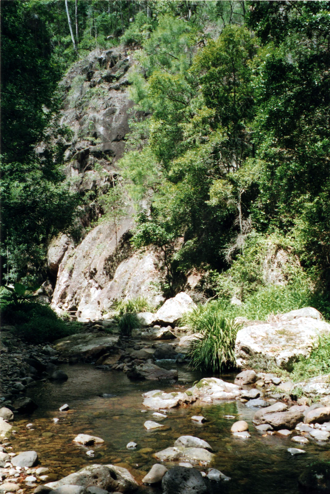
A rocky creek with shallow water flowing over stones and boulders, surrounded by dense green forest and a large rocky cliff face in the background
Couchy Creek flowing over rocks beneath a forested cliff face in north eastern New South Wales

Couchy Creek Nature Reserve history and protected-area timeline

Couchy Creek Nature Reserve was formally established in January 1999 after a period during which much of the surrounding Northern Rivers landscape was progressively cleared for agriculture and rural settlement. By the late twentieth century, the original mosaic of wet sclerophyll forest and lowland rainforest had been reduced to scattered fragments, increasing the conservation value of the surviving blocks.

The decision to gazette the area as a strict nature reserve signalled a deliberate shift toward protecting what remained of these forest communities rather than allowing further conversion. Since then, NSW National Parks and Wildlife Service has managed the reserve as a conservation-focused protected area, with the explicit aim of preserving its forest types, maintaining its function within the regional vegetation corridor, and safeguarding the threatened species recorded on site.

Couchy Creek Nature Reserve landscape and geographic character

The terrain of Couchy Creek Nature Reserve reflects the foothills and minor ridgelines typical of the far north eastern corner of New South Wales, where the Great Dividing Range gives way to the coastal lowlands. Creeks including the eponymous Couchy Creek cut through the reserve, creating shaded gullies and moister soils that influence vegetation patterns.

Above the creek lines, slopes support tall wet sclerophyll forest with a eucalypt canopy, while the more sheltered gullies retain patches of closed lowland rainforest. This transition between dry eucalypt-dominated forest on upper slopes and humid rainforest in the gullies gives the reserve a layered, structurally diverse landscape for its size. The pattern of clearing in surrounding farmland also makes the reserve visually stand out, with intact forest offering a contrast to the agricultural matrix that surrounds it.

Couchy Creek Nature Reserve ecosystems, habitats, and plant life

The reserve protects two main ecological communities: wet sclerophyll eucalyptus forest on broader slopes and ridges, and patches of lowland subtropical rainforest restricted to moister, more sheltered sites. Together they represent a forest mosaic that has become increasingly rare across the Northern Rivers.

The lowland rainforest component is the most ecologically sensitive part of the reserve, as lowland rainforest of this type has been extensively cleared throughout eastern Australia. Its preservation here helps maintain habitat structure, leaf litter complexity, and microclimatic conditions that many plant and animal species rely on. The reserve's role as part of a wider vegetation corridor further supports gene flow and recolonisation between otherwise isolated forest patches.

Couchy Creek Nature Reserve wildlife and species highlights

While the reserve is primarily recognised for its plant values, it also provides habitat for a range of forest-dependent fauna, including birds, insects, and small mammals typical of wet sclerophyll and lowland rainforest environments in the Northern Rivers. The combination of intact canopy, dense understorey, and proximity to other forested areas supports species that avoid open farmland.

The reserve's ten recorded threatened species include plants such as the Crystal Creek Walnut (Endiandra floydii) and Davidsons Plum (Davidsonia species), which reflect the broader pattern of botanically rich rainforest communities in this part of New South Wales. The presence of these plants also implies habitats for associated fauna, including fruit-eating birds and invertebrates that depend on rainforest resources.

Couchy Creek Nature Reserve conservation status and protection priorities

Couchy Creek Nature Reserve is classified as an IUCN Category Ia strict nature reserve, indicating that conservation is its primary management objective and that human activity is tightly restricted. Its protection is designed to preserve the integrity of both its wet sclerophyll forest and its patch of lowland rainforest, both of which have been reduced elsewhere in the region.

The reserve's conservation significance extends beyond its boundaries because it functions as a key node in a regional vegetation corridor. By maintaining forest cover and protecting threatened plant species, including the Crystal Creek Walnut, Couchy Creek helps buffer regional biodiversity against further habitat loss and supports ecological connectivity in an area dominated by agricultural land use.

Top sights and standout views in Couchy Creek Nature Reserve

A strict nature reserve protecting endangered lowland rainforest within a broader wet sclerophyll forest mosaic in the Northern Rivers.

Home to ten recorded threatened species, including the regionally restricted Crystal Creek Walnut and Davidsons Plum.

Part of an important vegetation corridor linking remaining forest fragments in a heavily cleared part of far north eastern New South Wales.

Monthly climate preview

Long term temperature and precipitation patterns across representative coordinates

Couchy Creek Nature Reserve Climate Normals and Annual Weather by Month

Couchy Creek Nature Reserve exhibits a measured annual temperature and precipitation rhythm spanning long term baseline records from nineteen ninety one to twenty twenty. Reviewing monthly averages reveals the underlying thermal spread across the representative coordinate before exploring the full twelve month profile.
Annual mean19 °C
13 °C24 °C
Jan24°
Feb24°
Mar22°
Apr20°
May16°
Jun14°
Jul13°
Aug14°
Sep17°
Oct20°
Nov22°
Dec23°
Warmest month
January

24.2 °C

Coolest month
July

13.2 °C

Wettest month
February

6 mm/day

Driest month
September

1.3 mm/day

Park location guide

Geography guide, regional context, and park location map for Couchy Creek Nature Reserve

Couchy Creek Nature Reserve park geography, regions, and map view in Australia

Understand where Couchy Creek Nature Reserve sits in Australia through a broader geographic reading of the surrounding landscape, nearby location context, and its mapped position within the national park landscape.

How Couchy Creek Nature Reserve fits into Australia

Australia is a constitutional monarchy and federal parliamentary democracy comprising six states and ten territories. With a population of nearly 28 million, it is one of the world's most urbanised countries, with most people concentrated on the eastern seaboard. The country has a high Human Development Index and is known for its cultural diversity, ancient Aboriginal heritage, and unique wildlife.

Wider geography shaping Couchy Creek Nature Reserve in Australia

Australia occupies the entire Australian continent, the island of Tasmania, and numerous smaller islands. It is the world's flattest and driest inhabited continent, featuring vast deserts in the interior (the Outback), tropical rainforests along the eastern coast, and a coastline bordering the Indian and Pacific Oceans.

Map view of Couchy Creek Nature Reserve

Use this park location map to pinpoint Couchy Creek Nature Reserve in Australia, understand its exact geographic position, and read its mapped placement within the surrounding landscape more clearly.

Pigeon | © OpenStreetMap contributors

Location context for Couchy Creek Nature Reserve

New South Wales

Visualizing lowland rainforest remnants and wet sclerophyll forest habitats

Couchy Creek Nature Reserve Photos and Landscape Scenery

Photographs capture the protected terrain, shaded gullies, and forest canopies defining Couchy Creek Nature Reserve. Visual documentation reveals the ecological structure of rare lowland rainforest fragments persisting within the agricultural matrix of northern New South Wales.

A rocky creek with shallow water flowing over stones and boulders, surrounded by dense green forest and a large rocky cliff face in the background

Park atlas

Compare regional protected areas and connected forest corridors across New South Wales

Explore Other Parks Near Couchy Creek Nature Reserve and Protected Landscapes

Browse nearby national parks and protected areas sharing the ecological traits of Couchy Creek Nature Reserve. Expanding the geographic view helps trace regional vegetation corridors and forest fragments across the surrounding landscape.
Nature reserveNew South Wales
About 2.7 km away#1 closest

North

Numinbah Nature Reserve: Mapping the Protected Rainforest and Volcanic Terrain of the Border Ranges

A high-altitude sanctuary within the New South Wales border landscape

Numinbah Nature Reserve is a key protected area defined by its rhyolite cliffs, steep volcanic slopes, and fertile basalt-enriched creek systems. Within this compact reserve, visitors can trace the intersection of subtropical and temperate rainforests, including rare stands of ancient Antarctic beech that anchor the ecological profile of this significant Border Ranges location.

Area
8.58 km²
Established
1981
IUCN
Ia
Relief
Mountain
National parkQueensland
About 3.2 km away#2 closest

North

Springbrook National Park National Park: Exploring Queensland's Protected Landscape Atlas

Mapped boundaries and regional geographic context for this Australian national park.

Springbrook National Park serves as a vital entry for understanding protected landscapes within Queensland, Australia. As a national park, it offers a distinct geographic profile, contributing to the broader atlas of conservation areas in northeastern Australia. Users can explore its specific mapped boundaries and appreciate its role in the regional geography, providing a factual basis for understanding the distribution and character of Australia's natural parklands.

Area
61.56 km²
Established
1990
IUCN
II
Relief
Mountain
National parkQueensland
About 5.3 km away#3 closest

Northwest

Lamington National Park: Ancient Gondwanan Rainforests and Volcanic Terrain in Queensland

Mapped protected landscape with over 500 waterfalls and unique cloud forests.

Lamington National Park stands as a key protected area within Queensland, recognized for its world-heritage status Gondwanan rainforests and striking volcanic geography. The park's landscape is characterized by its ancient Antarctic beech forests, a legacy of millions of years of volcanic activity that sculpted dramatic cliffs, plateaus, and deep valleys, punctuated by more than 500 waterfalls. Through its mapped boundaries and detailed geographic context, users can explore the exceptional biodiversity and unique terrain that defines this significant Australian national park.

Area
206 km²
Established
1915
IUCN
II
Visitors
1.2M annual
Nature reserveNew South Wales
About 11 km away#4 closest

West

Limpinwood Nature Reserve: Old-Growth Rainforest and Escarpment Landscapes in New South Wales

A protected subtropical wilderness sanctuary on the McPherson Range

Limpinwood Nature Reserve protects a vast extent of old-growth subtropical rainforest in far north-eastern New South Wales. Characterized by steep escarpment terrain and continuous forest canopy, this wilderness area serves as a critical refuge for biodiversity and is recognized as part of the Gondwana Rainforests of Australia, maintaining a strict low-intervention approach to conservation.

Area
26.46 km²
Established
1963
IUCN
Ib
Relief
Mountain
National parkQueensland
About 12 km away#5 closest

Northeast

Nicoll Scrub National Park: Queensland National Park Geography and Landscape

Explore the mapped boundaries and regional context of this protected area.

Nicoll Scrub National Park is a designated national park contributing to the rich protected landscape tapestry of Queensland, Australia. This entry provides detailed information focused on its geographic identity, allowing for atlas-style exploration of its mapped boundaries and its role within the state's natural geography. Understand the specific context of this park as a protected natural area.

Area
0.27 km²
Established
1986
IUCN
II
Relief
Mountain
National parkNew South Wales
About 13 km away#6 closest

South

Wollumbin National Park: Protected Landscape Atlas and Geographic Context

Explore New South Wales's protected area boundaries.

Delve into the specifics of Wollumbin National Park, a designated national park situated in New South Wales. This entry focuses on its protected landscape identity, mapping its geographic boundaries and regional context for dedicated atlas exploration. Understand how Wollumbin National Park fits into the larger mosaic of Australia's protected areas.

Area
24 km²
Established
1967
IUCN
II
Relief
Mountain
National parkAustralia
About 13 km away#7 closest

West

Border Ranges National Park: A Key Protected Landscape in Australian Geography

Explore its mapped boundaries and regional terrain.

Border Ranges National Park represents an important national park entity within Australia. This page facilitates detailed exploration of the park's protected landscape, its surrounding geography, and its specific place within the broader Australian atlas. Engage with the mapped terrain and understand the distinct regional context that defines this protected natural area.

Area
317.29 km²
Established
1979
IUCN
II
Relief
Mountain
National parkNew South Wales
About 19 km away#8 closest

Southwest

Mebbin National Park National Park: Protected Landscape Atlas and Regional Geography

Explore mapped park boundaries and natural terrain in New South Wales.

Mebbin National Park represents a vital national park entity, offering rich geographic context for structured discovery. Users can investigate its protected landscape characteristics and mapped boundaries within New South Wales. This park's unique natural terrain and regional setting are essential for understanding its place in the Australian conservation atlas, providing detailed insights for geographic exploration and mapped landscape analysis.

Area
38 km²
IUCN
II
Relief
Mountain
Climate
Subtropical

Common questions about visiting, size, designation, and location context for Couchy Creek Nature Reserve

Couchy Creek Nature Reserve FAQs for park facts, access, geography, and protected area context

Find quick answers about Couchy Creek Nature Reserve, including protected-area facts, park geography, trail and visitor context, and how the park fits into its surrounding country and regional landscape.
MoriAtlas Explorer

Continue Your Protected Areas Search Across the Global Atlas

Deepen your exploration by continuing the structured search for national parks and protected areas worldwide. Utilize the comprehensive filtering capabilities to compare different conservation landscapes and refine your understanding of global park geography. Discover more about the distribution and characteristics of protected natural areas.

Global natural geography