Mori Atlas logo
Protected areaCoupar Angus

Analyzing the protected landscape and regional geography within the Perth and Kinross council area

Coupar Angus Protected Area: Mapped Boundaries, Terrain, and Regional Geographic Overview

(Rezerwat przyrody „Jezioro Warnołty”)

Coupar Angus represents a distinct protected area situated within the fertile southern landscapes of the Perth and Kinross council area. This mapping resource provides a comprehensive view of the terrain and regional geography surrounding this site. Gain insights into the boundary distribution and spatial context that define this notable Scottish location, supporting a deeper understanding of its placement within the wider regional framework.

nature reservefaunistic reservewetlandshallow lakelake Śniardwy systemwaterbirds

Coupar Angus

Protected area

Park overview

Structured park overview, official facts, and landscape profile for Jezioro Warnołty Nature Reserve

Jezioro Warnołty Nature Reserve park facts, protected area profile, and essential visitor context

Review the core facts for Jezioro Warnołty Nature Reserve, including designation, size, terrain, visitor scale, habitats, and operating context in one park-focused overview.

About Jezioro Warnołty Nature Reserve

Jezioro Warnołty Nature Reserve is a faunistic protected area in northeastern Poland, focused squarely on the conservation of a heavily vegetated branch lake that extends westward from the southern reaches of Lake Śniardwy. Established in 1976, the reserve reflects a long-standing recognition in the Warmia and Mazury region of the importance of even relatively small wetlands as breeding and feeding habitat for waterbirds, marsh birds, and fish-eating raptors.

Geographically, the reserve sits within the Ruciane-Nida commune in Pisz County, set deep in the lake country of the Great Masurian Lakes region. The lake itself is a shallow, slowly filling waterbody, and its naturally progressing overgrowth is part of what gives it its ecological value. Fringe habitats include dense sedge beds, willow-dominated shrub thickets along the shore, and patches of alder swamp forest, all of which grade into the surrounding landscape that lies within the Mazury Landscape Park.

Although its surface area is modest, Warnołty holds an outsized importance for birdlife in the region. The reserve's mixed structure of open water, emergent marsh vegetation, and islands is highly attractive to nesting waterbirds and to raptors that hunt over the lake and its margins. The presence of Poland's largest regional great cormorant colony on one of the lake's islands underlines the ornithological weight of the site, even as that same colony introduces local conservation management challenges through nutrient enrichment from guano.

As an actively managed reserve, Warnołty is treated not just as a static protected area but as a living wetland system. Active management allows for interventions designed to balance the ecological roles of its bird populations and to mitigate pressures on water quality. Within the broader Masurian Lakes network, the reserve remains a reference site for lake-margin habitats and for the bird communities that depend on them.

Quick facts and research context for Jezioro Warnołty Nature Reserve

Jezioro Warnołty is a faunistic nature reserve created in 1976 by Polish legal decree. It lies in the Ruciane-Nida commune of Pisz County, in the Warmian-Masurian Voivodeship, within the Mazury Landscape Park. The reserve protects a shallow, overgrown arm of Lake Śniardwy, the largest lake in Poland, and covers about 376 hectares. The area is designated for active conservation and is managed explicitly for its ornithological and wetland values.

Protection and recognition

Analysis of terrestrial protection scope and international recognition data

Coupar Angus Protection Status and Documented Conservation Designations

Coupar Angus maintains a recorded terrestrial protection scope alongside documented management history. International recognition sources outline official conservation designations and administrative frameworks associated with the landscape.

Protection details

Protection scope
Terrestrial
Transboundary protection
No
Park context

Deeper park guide and search-rich context for Jezioro Warnołty Nature Reserve

Jezioro Warnołty Nature Reserve history, landscape, wildlife, and travel context

Explore Jezioro Warnołty Nature Reserve through its history, landscape character, ecosystems, wildlife, conservation priorities, cultural context, and seasonal travel timing in a structured park guide built for atlas discovery and search intent.

Why Jezioro Warnołty Nature Reserve stands out

Warnołty is best known as a breeding and foraging ground for waterbirds and wetland birds, including species such as black tern, common tern, white-tailed eagle, mute swan, and great crested grebe. The reserve also hosts the largest known colony of great cormorants in the Warmia and Mazury region, located on an island within the lake. Its combination of open water, reed and sedge beds, willow thickets, and alder forest gives the reserve a layered habitat structure that supports a high diversity of birdlife despite its relatively modest size. Several rare raptors, including black kite and red kite, are also recorded here as foraging visitors drawn by the abundance of prey around the lake margins.

Jezioro Warnołty Nature Reserve history and protected-area timeline

The Jezioro Warnołty reserve was established in 1976 under Polish legal decree, titled Monitor Polski of 1976, number 24, item 108. The founding instrument set out an initial area of approximately 373 hectares, with the reserve's currently recognized extent later recorded as about 376 hectares.

Its creation was tied to growing awareness during the 1970s of the ecological importance of the Masurian wetlands, particularly as breeding and foraging habitat for waterbirds on the increasingly vegetated southern bays of Lake Śniardwy. The reserve was placed within the framework of the broader Mazury Landscape Park, aligning local-level faunistic protection with regional landscape safeguarding.

In later decades, the reserve's profile rose further as ornithological monitoring documented major breeding colonies, including the largest great cormorant colony in the Warmia and Mazury region. That growing bird population also drew attention to the ecological pressures that intense colonial nesting can place on a small lake, and the reserve was designated for active conservation management to address these dynamics.

Jezioro Warnołty Nature Reserve landscape and geographic character

The landscape of Warnołty is dominated by its eponymous lake, a shallow, flat-bottomed body of water that represents an old arm or bay of Lake Śniardwy, Poland's largest lake by surface area. As a result of long-natural processes of sedimentation and plant succession, the lake has progressively shallowed and is heavily overgrown along its margins, with emergent vegetation extending well out into open water.

Surrounding the lake is a layered wetland mosaic that defines the visual and ecological character of the reserve. Dense stands of sedges form the principal emergent marsh vegetation, while willow shrub thickets fringe the wetter shores and low-lying ground. Patches of alder swamp forest occupy still-flooded sections of the shoreline, creating darker, sheltered stands that contrast with the brighter open-water zones.

The terrain is uniformly low and flat, typical of post-glacial lake country in the Masurian region, with no pronounced relief. Instead, the landscape's visual richness comes from the transitions between open water, reed and sedge beds, shrub thickets, and swamp woodland, viewed against a wider backdrop of lake, forest, and farmland that characterizes the Mazury Landscape Park.

Jezioro Warnołty Nature Reserve ecosystems, habitats, and plant life

Ecologically, Warnołty is a classic example of a maturing lowland lake ecosystem transitioning toward marshland. Its shallow water column, high nutrient input from surrounding wetlands and, more recently, from colonial waterbirds, has accelerated the process of overgrowth, producing large areas of emergent vegetation that now dominate the lake's edge zones.

The wetland vegetation is dominated by sedges that form tall, dense stands along the shoreline. These grade landward into willow thickets, which thrive in the periodically flooded zone between open water and drier ground. In the wettest, most sheltered sections, the willow zone gives way to alder swamp forest, a habitat type that combines standing water for much of the year with a canopy of moisture-loving broadleaf trees.

Together these habitats form a continuous gradient from open water through marsh to swamp woodland, supporting high plant diversity relative to the reserve's size. The combination of aquatic, marsh, shrub, and forest habitats also creates a varied structural environment that is critical to the reserve's birdlife, providing nest sites, cover, foraging space, and roosting areas across a compact geographic area.

Jezioro Warnołty Nature Reserve wildlife and species highlights

Warnołty is recognized primarily for its birdlife, which is the core reason the reserve was given its faunistic designation. The reserve supports breeding populations of several waterbird and marshland species typical of the Masurian lake country.

Among the regularly recorded nesting species are black tern and common tern, which use the lake margins and emergent vegetation, along with mute swan, great crested grebe, and water rail, which are characteristic of the open-water and reed-edge zones. Mallard and common coot are also part of the regular breeding community. Grey heron hunts along the lake edges, exploiting the rich fish and amphibian life in the shallow water.

The reserve is also notable for several raptors. Both black kite and red kite are recorded here, with Warnołty functioning as an important foraging ground for these relatively uncommon species, drawn by abundant prey around the lake margins. White-tailed eagle is another notable presence, reflecting the reserve's role as part of a wider raptor-friendly wetland network across the Masurian Lakes.

Perhaps most strikingly, one of the lake's islands hosts the largest known colony of great cormorants in the Warmia and Mazury region. This dense colonial nesting aggregation is one of the reserve's defining ornithological features. At the same time, the sheer numbers of cormorants, and the nutrient load their guano contributes, have been identified as a significant driver of ongoing changes in water quality and shoreline conditions within and around the colony site.

Jezioro Warnołty Nature Reserve conservation status and protection priorities

Conservation at Warnołty operates on two scales: a regional landscape scale, through the reserve's inclusion in the Mazury Landscape Park, and a site-specific scale, through its designation as an actively managed faunistic reserve. The active management designation acknowledges that the reserve is a dynamic ecological system requiring targeted interventions rather than passive protection alone.

A central conservation issue is the interaction between the great cormorant colony and the lake environment. While the colony is a feature of significant ornithological and conservation interest in its own right, the heavy nutrient loading from cormorant guano has been linked to degradation of water quality and shoreline conditions in and around the colony. This pollution-related pressure from nitrogen and phosphorus enrichment is one of the most visible conservation challenges the reserve faces.

The lake's natural shallowing and overgrowth also represent a long-term ecological trajectory that conservation planning must address. Active management in this context typically aims to maintain a balanced mosaic of open-water, marsh, shrub, and woodland habitats that continues to support the reserve's breeding waterbirds, foraging raptors, and associated wetland flora, while mitigating as far as possible the most acute local pressures from colonial nesting.

Top sights and standout views in Jezioro Warnołty Nature Reserve

The standout features of Jezioro Warnołty Nature Reserve are its layered wetland habitats, its dense waterbird breeding community, and its position as a key foraging area for several regionally uncommon raptors. The reserve's compact mosaic of open water, sedge marsh, willow thickets, and alder forest packs a remarkable diversity of bird-relevant habitat structure into a small footprint.

The lake island holding the largest great cormorant colony in the Warmia and Mazury region is a defining feature, combining exceptional ornithological significance with a notable conservation-management challenge. The reserve's location within the Mazury Landscape Park also situates Warnołty within one of Poland's most iconic lake-country protected landscapes, reinforcing its role as a smaller but important node in the wider Great Masurian Lakes system.

Best time to visit Jezioro Warnołty Nature Reserve

Warnołty is most rewarding for visitors interested in birdlife and wetland landscapes during the warmer months, when the breeding season brings the highest songbird, waterbird, and raptor activity. Late spring and early summer are typically the peak period for observing nesting terns, grebes, swans, and herons, and for witnessing feeding flights of kites and other raptors over the lake.

In autumn, the reserve's wetland character continues to attract migrating waterfowl and concentrations of cormorants, while winter typically brings quieter conditions and frozen or partially frozen lake margins. Because of its shallow, largely overgrown water and the active nature of the reserve, visitors primarily experience the site through observation from the surrounding paths and shoreline rather than through direct access to the lake itself.
Monthly climate preview

Review measured monthly precipitation and average temperature cycles across the year

Coupar Angus Climate Normals and Long Term Temperature Patterns

Long term representative measurements for Coupar Angus reveal a steady annual rhythm of recorded temperatures and precipitation amounts. Detailed monthly climate profiles provide deeper insight into temperature ranges and precipitation normals across the coordinate point.
Annual mean8 °C
3 °C14 °C
Jan
Feb
Mar
Apr
May
Jun12°
Jul14°
Aug14°
Sep12°
Oct
Nov
Dec
Warmest month
July

14 °C

Coolest month
January

2.7 °C

Wettest month
October

3.4 mm/day

Driest month
April

2.2 mm/day

Park location guide

Geography guide, regional context, and park location map for Jezioro Warnołty Nature Reserve

Jezioro Warnołty Nature Reserve park geography, regions, and map view in United Kingdom

Understand where Jezioro Warnołty Nature Reserve sits in United Kingdom through a broader geographic reading of the surrounding landscape, nearby location context, and its mapped position within the national park landscape.

How Jezioro Warnołty Nature Reserve fits into United Kingdom

The United Kingdom is a parliamentary constitutional monarchy located in northwestern Europe, consisting of four constituent countries: England, Scotland, Wales, and Northern Ireland. As a major global power with over 69 million residents, it maintains significant international influence in politics, economics, and culture.

Wider geography shaping Jezioro Warnołty Nature Reserve in United Kingdom

The United Kingdom is an island nation located in northwestern Europe, surrounded by the Atlantic Ocean, North Sea, English Channel, Celtic Sea, and Irish Sea. It shares a land border with the Republic of Ireland to the west. The territory includes the island of Great Britain, the northeastern portion of Ireland, and most of the smaller British Isles islands.

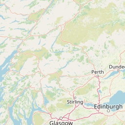
Map view of Jezioro Warnołty Nature Reserve

Use this park location map to pinpoint Jezioro Warnołty Nature Reserve in United Kingdom, understand its exact geographic position, and read its mapped placement within the surrounding landscape more clearly.

Pigeon | © OpenStreetMap contributors

Location context for Jezioro Warnołty Nature Reserve

Perth and Kinross
Park atlas

Compare surrounding regional landscapes and connected protected territories.

Other Protected Areas and National Parks Near Coupar Angus for Regional Comparison

Browse other parks near Coupar Angus to evaluate surrounding regional geography and protected-area networks. Comparing nearby natural landscapes reveals broader terrain patterns across the wider territory.
Watercolor painting depicting mountains, forested hills, and a river in a scenic landscape
National parkScotland
About 24 km away#1 closest

North

Cairngorms National Park: Explore Scotland's Largest Protected Mountain Landscape

Mapped boundaries and arctic-alpine geography.

As the United Kingdom's largest national park, Cairngorms National Park in Scotland presents a vast expanse of distinctive arctic-alpine terrain and ancient Caledonian forests. This protected landscape offers a unique opportunity to explore mapped geographic features, from its extensive mountain plateaus to its vital river systems. Discover the contours and context of this significant natural area within the broader atlas of Scotland's protected lands.

Area
4,528 km²
Established
2003
IUCN
V
Visitors
1.9M annual
A horizontal watercolor painting showing a soft, impressionistic view of green hills, trees, and a lake, set against a light background.
Protected landscapePerth and Kinross
About 44 km away#2 closest

Northwest

Loch Tummel National Scenic Area: Geography and Mapped Protected Landscape Features

Highland landscape corridor in Perth and Kinross

Loch Tummel National Scenic Area encompasses a vital Highland corridor where freshwater lochs, river gorges, and managed woodlands intersect. This overview focuses on the physical geography of the Tummel valley, providing a detailed look at the protected land, elevation changes, and the hydro-electric history that shaped the current terrain of this scenic region.

Area
90.1 km²
Established
1981
Relief
Upland
Climate
Temperate
Watercolor illustration showing mountains, green forests, a loch, and a river in a landscape
National parkScotland
About 53 km away#3 closest

West

Loch Lomond and The Trossachs National Park: Mapped Landscapes and Terrain

Regional geography and protected Highland boundaries in Scotland

Loch Lomond and The Trossachs National Park covers a vast array of protected habitats, from coastal sea lochs to high-altitude Munros. This geographic profile outlines the park's position across the Highland Boundary Fault, highlighting its role as a core protected area for Caledonian forests and freshwater lake ecosystems within Scotland.

Area
1,865 km²
Established
2002
IUCN
V
Visitors
2.9M annual
A soft watercolor painting of a landscape featuring green rolling hills, a suggestion of a reflective body of water, and layers of purple distant mountains against a light sky.
National parkScotland
About 97 km away#4 closest

Southwest

Loch Lomond and The Trossachs National Park: Geographic and Protected Area Overview

Tracing Highland and Lowland transition zones in Scotland

This protected area captures the contrast between the rugged mountainous terrain of the northern Trossachs and the gentler southern loch basins. By examining the Highland Boundary Fault, users can analyze how glaciers carved the landscape, creating the deep fjord-like trenches and islands that define the region's unique natural geography.

Area
71 km²
Established
2002
Relief
Mountain
Climate
Temperate
Marine protected areaScotland
About 103 km away#5 closest

East

Firth of Forth Banks Complex: Offshore Marine Protected Area Geography and Seabed Atlas

Dynamic sand and gravel ridges off the coast of Scotland

The Firth of Forth Banks Complex encompasses a series of prominent submarine sediment banks at the meeting point of the Firth of Forth and the North Sea. These raised seafloor formations, characterized by strong currents and varied substrate types, function as an essential component of the marine conservation network in Scotland. The area sustains rich benthic biodiversity and supports ecologically significant populations of fish and long lived bivalves.

Area
2,130 km²
Established
2014
Relief
Lowland
Climate
Temperate
Protected landscapeScottish Borders
About 104 km away#6 closest

South

Upper Tweeddale National Scenic Area: Geography and Protected Landscape Atlas Map

Regional landscape profile in the Scottish Borders

Upper Tweeddale National Scenic Area encompasses 12,770 hectares of refined southern Scottish countryside. This atlas entry provides an overview of the area landscape, defined by its narrow river valley, tributary glens, and the significant upland plateau of the Tweedsmuir Hills. Examine the geographic intersection of protected habitats, historic estates, and the winding course of the River Tweed.

Area
128 km²
Established
1981
Relief
Upland
Climate
Temperate
A soft, artistic watercolor painting of a Scottish sea loch surrounded by gentle, green hills against a faint mountainous background.
Marine protected areaArgyll and Bute
About 111 km away#7 closest

Southwest

Loch Goil Marine Protected Area: Geography and Landscape Overview

Protected marine habitats in the Argyll and Bute region

Loch Goil offers a distinct look at an enclosed, sea loch landscape in western Scotland. Surrounded by the Arrochar Alps and steep conifer slopes, this marine protected area demonstrates the intersection of Highland wilderness and formal conservation zones. Use this atlas resource to understand its topographical form and regional context.

Established
2014
Relief
Mountain
Climate
Temperate
Access
Moderate access
Marine protected areaArgyll and Bute
About 122 km away#8 closest

West

Loch Creran Marine Protected Area: Atlas and Coastal Geography of Argyll and Bute

Mapped tidal basins, flame shell reefs, and Atlantic oakwood habitats

Loch Creran is a primary example of integrated marine and coastal conservation on the west coast of Scotland. Characterized by its long, narrow form and dramatic bathymetry, the loch creates a rich environment where rapid tidal currents meet sheltered forest shorelines. This record provides a detailed look at the geographic structure, protected seabed zones, and the transition from sea loch to the ancient woodlands at the head of the inlet.

Area
12 km²
Established
2014
IUCN
IV
Relief
Lowland

Common questions about visiting, size, designation, and location context for Jezioro Warnołty Nature Reserve

Jezioro Warnołty Nature Reserve FAQs for park facts, access, geography, and protected area context

Find quick answers about Jezioro Warnołty Nature Reserve, including protected-area facts, park geography, trail and visitor context, and how the park fits into its surrounding country and regional landscape.
MoriAtlas Explorer

Continue Your Protected Areas Search Across the Global Atlas

Deepen your exploration by continuing the structured search for national parks and protected areas worldwide. Utilize the comprehensive filtering capabilities to compare different conservation landscapes and refine your understanding of global park geography. Discover more about the distribution and characteristics of protected natural areas.

Global natural geography