Mori Atlas logo
Nature reserveCrom Estate

Discover the complex shoreline terrain and ancient woodland boundaries of this County Fermanagh conservation area.

Crom Estate Nature Reserve: A Detailed Geographic Exploration of Protected Riparian Landscapes

Crom Estate stands as a significant nature reserve along the banks of Upper Lough Erne in County Fermanagh, defined by a unique mosaic of riparian forest and fragmented island geography. This protected landscape encompasses centuries-old woodland, marshy bays, and historical ruins, offering a dense, water-influenced environment that remains a focal point for conservation in Northern Ireland. Map the terrain across its sprawling 1,350 acres and examine the intersection of deep-rooted forestry and the lough shoreline.

National Trustnature reserveCounty FermanaghNorthern IrelandUpper Lough Ernelough shoreline

Crom Estate

Nature reserve

Park overview

Structured park overview, official facts, and landscape profile for Crom Estate

Crom Estate park facts, protected area profile, and essential visitor context

Review the core facts for Crom Estate, including designation, size, terrain, visitor scale, habitats, and operating context in one park-focused overview.

About Crom Estate

Crom Estate is a National Trust nature reserve set along the south-eastern shores of Upper Lough Erne in County Fermanagh, Northern Ireland. It occupies around 1,350 acres of gently undulating shoreline ground whose dominant feature is riparian forest, the kind of wet, riverside woodland that grows where slow-moving water meets naturally flooded ground.

The reserve forms part of a trio of National Trust estates in the county, siting alongside Florence Court and Castle Coole, and together they represent the Trust's principal countryside presence in Fermanagh. At Crom, the woodland is the headline feature: in places the trees are so old that physical access has had to be restricted, suggesting a continuous tree cover that long predates the modern estate boundaries. The shoreline is broken into bays, inlets, and small islands, with Inisherk forming part of the Crom Castle demesne within the neighbouring barony of Knockninny.

The estate is open to the public and supports walking, quiet recreation, and weddings, with several cottages available to rent on the grounds. Visitors can wander among the ruins of Old Crom Castle and pass by an old bowling green and garden area, while the open ground near the old castle carries species-rich grassland that bursts into colour in early summer. The newer Crom Castle, built in 1840 to a neo-Tudor design by the architect Edward Blore, remains the private seat of the Earl of Erne and is not accessible to visitors, but its grounds and shoreline contribute to the setting of the wider estate.

Crom Estate also has a strong place in current public consciousness in Northern Ireland. In 2026 it was announced that BBC Springwatch would be based at Crom for the first time, marking the first edition of the programme held in Northern Ireland and the first time the show had been based anywhere outside Great Britain.

Quick facts and research context for Crom Estate

Crom Estate is managed by the National Trust and covers about 1,350 acres of mostly riparian forest on the southern shore of Upper Lough Erne in County Fermanagh, Northern Ireland. It is one of three National Trust estates in County Fermanagh alongside Florence Court and Castle Coole, and most of the present estate lies within the historic barony of Coole.

The reserve is known for ancient trees, shoreline woodland, and a network of islands within the lough, including Inisherk in the neighbouring barony of Knockninny. Old Crom Castle, a Plantation-era ruin, and the surrounding lawns and grassland sit inside the public estate, while the 1840 Crom Castle itself remains privately owned and is not open to visitors.

Protection and recognition

Terrestrial protected area management scope and recognition records

Crom Estate Protection Status and Documented Conservation Framework

Crom Estate maintains a documented terrestrial protection scope within the regional conservation framework. Official records compile administrative boundaries and designation details for environmental analysis.

Protection details

Protection scope
Terrestrial
Transboundary protection
No
Park context

Deeper park guide and search-rich context for Crom Estate

Crom Estate history, landscape, wildlife, and travel context

Explore Crom Estate through its history, landscape character, ecosystems, wildlife, conservation priorities, cultural context, and seasonal travel timing in a structured park guide built for atlas discovery and search intent.

Why Crom Estate stands out

Crom Estate is best known for its extensive ancient riparian woodland along Upper Lough Erne, including trees so old that they are physically protected from disturbance. The combination of broad shorelines, sheltered bays, wooded islands, and old-growth canal-side forest gives the estate a particularly rich woodland character compared with many other Northern Irish country estates. It is also known for its layered history: a 17th-century Plantation castle ruin, a 19th-century neo-Tudor private castle, sweeping grassland near the old castle, and a stretch of lough shore that frames the whole landscape. The estate's selection as the base for Springwatch 2026 brought it a wider public profile.
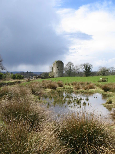
A stone tower ruin stands in a green field behind a small marshy pool with tall grasses in the foreground, under a partially cloudy sky.
The ruins of the old castle at Crom Estate surrounded by marshy terrain.

Crom Estate history and protected-area timeline

Crom's origins lie in the Plantation of Ulster. In 1611, Michael Balfour, a Scottish Laird from Mountwhinney, built the first house at Crom on the shore of Upper Lough Erne opposite Inishfendra Island. The castle followed the standard pattern for Plantation houses in Ulster, constructed of lime and stone and enclosed within a defensive bawn. The house was attacked twice by Jacobite forces before being burnt down in the early 1760s, leaving the ruin that still stands on the estate today.

A second, much larger Crom Castle was completed in 1840, designed by the Scottish architect Edward Blore in the neo-Tudor style. This castle became the seat of the Crichton family, the Earls of Erne. It remains a private residence and is not open to the public, though its setting defines much of the present estate's atmosphere.

A decisive modern moment came in 1987, when the 6th Earl of Erne, often known simply as Harry Erne, gave the estate to the National Trust, securing its long-term protection and its present identity as a publicly accessible nature reserve. The estate has since become one of the most significant woodland and shoreline reserves in Northern Ireland, and in 2026 it was selected as the base for BBC Springwatch, the first time the programme has operated from Northern Ireland.

Crom Estate landscape and geographic character

The landscape of Crom Estate is shaped by water. Upper Lough Erne's southern shoreline cuts deeply into the estate, producing a maze-like margin of bays, inlets, and small islands, with wooded promontories pushing out into the lough and sheltered bays cutting back into the shore. Inisherk is the most notable of these islands and forms part of the wider Crom Castle demesne.

Along this shoreline, riparian woodland rises directly from the lough edge. The forest is genuinely old in places, with stands old enough to require restricted public access, and the impression is of a wooded shoreline that has been more or less continuously wooded for centuries. Away from the water, flatter ground around the old castle supports species-rich grassland, while old garden features and a bowling green hint at the estate's long history as a designed landscape.

The result is a quiet, layered environment in which water, woodland, and open ground sit closely together, offering a sense of distance and remoteness even though the estate lies within a working rural county.
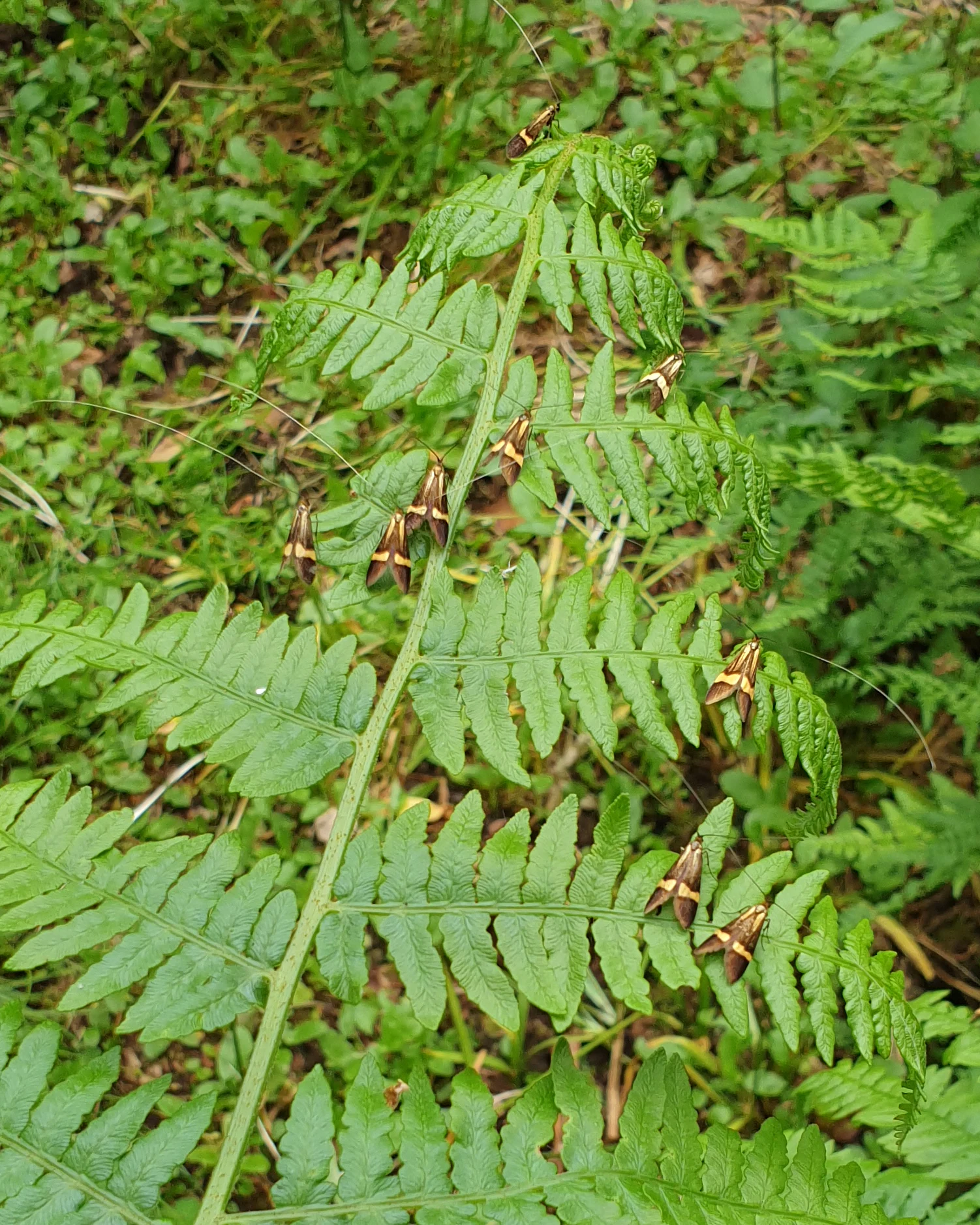
Several small moths with dark brown wings and distinctive yellow bands resting on the green leaf of a fern.
A cluster of Yellow-barred Longhorn moths resting on a bracken frond at Crom Estate.

Crom Estate ecosystems, habitats, and plant life

Crom is fundamentally a wooded, wetland-edge reserve. The dominant habitat is riparian forest, a distinctive ecological environment in which the water table, seasonal flooding, and slow-moving shoreline waters together create conditions for trees, ground flora, and associated fauna that are quite different from those in drier inland woodland.

The presence of trees so old that access has to be restricted suggests near-continuous cover and well-developed woodland structure, including veteran trunks, decaying wood, and the microhabitats that come with them. Around the old castle, the more open ground supports species-rich grassland, where summer brings a burst of flowering plants, while sheltered bays and reed-fringed shoreline edges extend the woodland into a wetter transitional zone between forest and open water.

Crom Estate conservation status and protection priorities

Crom Estate's conservation significance rests largely on its riparian woodland. Ancient, water-influenced forests of this kind are uncommon in intensively managed landscapes, and the evidence that some of its stands are old enough to require restricted access reflects centuries of continuous tree cover. The transfer of the estate to the National Trust in 1987 by the 6th Earl of Erne secured this character in long-term public ownership.

The combination of shoreline habitat, woodland, and open species-rich grassland gives the estate a layered ecological profile: woodland birds and associated invertebrates along the shore, transitional wetland species along the bays, and grassland communities in the more open ground around the ruins. Selection of Crom as the 2026 base for Springwatch reflected its strength as a place where woodland, wetland, and open-country species can all be observed within a compact area.

Crom Estate cultural meaning and human context

Crom sits within the cultural landscape of the Ulster Plantation. The 17th-century Scottish-built castle, with its bawn and lime-and-stone fabric, is a direct physical reminder of the settled colonial phase that reshaped much of Ulster, and its ruin remains visible to estate visitors. The later neo-Tudor castle, designed by Edward Blore and completed in 1840, represents the continued evolution of the Carr-era, or in this case Crichton-era, aristocratic estate.

Lough Erne has long been a centre for inland water recreation in Ireland, and the estate's bays and shoreline have historically hosted social gatherings on the water. In 2010, a regatta recreating races originally held in the 1890s brought classic yachts and steamboats onto Trial Bay, with boats mooring each evening off the Crom boathouse, underlining the long connection between the estate and the social life of the lough.

Top sights and standout views in Crom Estate

The Crom Estate's standout quality is the marriage between an ancient riparian woodland and the broad, island-dotted shoreline of Upper Lough Erne. Few Northern Irish reserves combine such well-developed, water-influenced old forest with publicly accessible shoreline, accessible bays, and cultural landmarks such as the ruins of Old Crom Castle.

What also distinguishes the estate is the layered historical canvas: a Plantation-era castle ruin, a 19th-century private neo-Tudor castle, designed parkland features around the old castle grounds, and a working landscape still managed today by the National Trust for both conservation and quiet public enjoyment.

Best time to visit Crom Estate

Late spring and summer are particularly rewarding at Crom, when the species-rich grassland near the old castle comes into full bloom and woodland and water edges are at their most active. Late spring gives the brightest displays of ground flora and the freshest greens in the riparian woodland, while high summer offers longer daylight for walking the shoreline and exploring the bays around the castle ruins.

Early autumn brings quieter trails, warmer-toned foliage along the lough shore, and reflective water conditions that suit the estate's slower-paced atmosphere. Winter visits offer stark landscapes with open views across the lough and bare branches that reveal the structure of the ancient woodland more clearly.
Monthly climate preview

Long-term monthly temperature and precipitation rhythm across the estate coordinate

Crom Estate Climate Normals, Average Temperature and Precipitation Patterns

Representative coordinate records show measured monthly averages ranging from lower winter temperatures to warmer summer maximums alongside consistent precipitation rates. Examining the full twelve-month profile reveals detailed baseline patterns for average temperature and monthly precipitation across Crom Estate.
Annual mean9 °C
4 °C15 °C
Jan
Feb
Mar
Apr
May10°
Jun13°
Jul15°
Aug14°
Sep12°
Oct
Nov
Dec
Warmest month
July

14.7 °C

Coolest month
January

4.1 °C

Wettest month
November

3.7 mm/day

Driest month
May

2.6 mm/day

Park location guide

Geography guide, regional context, and park location map for Crom Estate

Crom Estate park geography, regions, and map view in United Kingdom

Understand where Crom Estate sits in United Kingdom through a broader geographic reading of the surrounding landscape, nearby location context, and its mapped position within the national park landscape.

How Crom Estate fits into United Kingdom

The United Kingdom is a parliamentary constitutional monarchy located in northwestern Europe, consisting of four constituent countries: England, Scotland, Wales, and Northern Ireland. As a major global power with over 69 million residents, it maintains significant international influence in politics, economics, and culture.

Wider geography shaping Crom Estate in United Kingdom

The United Kingdom is an island nation located in northwestern Europe, surrounded by the Atlantic Ocean, North Sea, English Channel, Celtic Sea, and Irish Sea. It shares a land border with the Republic of Ireland to the west. The territory includes the island of Great Britain, the northeastern portion of Ireland, and most of the smaller British Isles islands.

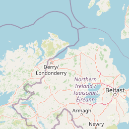
Map view of Crom Estate

Use this park location map to pinpoint Crom Estate in United Kingdom, understand its exact geographic position, and read its mapped placement within the surrounding landscape more clearly.

Pigeon | © OpenStreetMap contributors

Location context for Crom Estate

County FermanaghNorthern Ireland

Visual reference collection highlighting protected riparian forests, open waters, and historical ruins across the reserve

Crom Estate Photos and Scenery: Exploring Ancient Woodlands and Lough Shorelines

Visual documentation captures the complex interplay of ancient riparian forest and island-dotted lough waters defining the protected reserve. Examining detailed landscape photography reveals terrain features, vegetation zones, and historical remnants shaping the local ecosystem.

A stone tower ruin stands in a green field behind a small marshy pool with tall grasses in the foreground, under a partially cloudy sky.

A meadow filled with tall green grasses and scattered wildflowers, including a small purple orchid in the foreground.

Several small moths with dark brown wings and distinctive yellow bands resting on the green leaf of a fern.

Park atlas

Compare adjacent wetland reserves and woodland landscapes across County Fermanagh

Exploring Parks Near Crom Estate and Surrounding Regional Protected Areas

Continue exploring protected natural areas by comparing other remarkable estates and woodland reserves situated near Crom Estate. Broaden your geographic perspective by examining connected lough shores and regional conservation landscapes throughout the wider territory.
Protected landscapeCounty Fermanagh
About 39 km away#1 closest

Northwest

Castle Archdale Protected Landscape in County Fermanagh: Geography and Map Overview

Lakeside woodland and historic terrain on Lower Lough Erne

Located on the shores of Lower Lough Erne, Castle Archdale represents a unique protected landscape in County Fermanagh. The area features a complex mosaic of sheltered inlets, mature woodland, and open parkland that characterises the Fermanagh lakelands. Beyond its physical terrain, the site is defined by its historical significance, from seventeenth century estate remnants to its role as a pivotal wartime flying boat base, providing a rich context for geographic and environmental exploration.

Relief
Lowland
Climate
Temperate
Access
Easy access
Scope
Terrestrial
Nature reserveNorthern Ireland
About 78 km away#2 closest

Northeast

Oxford Island National Nature Reserve: Protected Wetland Landscapes of Northern Ireland

Lakeshore habitats and woodland geography at Lough Neagh

Oxford Island is a prominent nature reserve where terrestrial woodland meets the expansive waters of Lough Neagh. The site showcases a transition of reed beds and meadows that serve as vital ecological assets within the regional geography of Northern Ireland, offering a dense, accessible look at lowland wetland environments.

Area
1.14 km²
Relief
Lowland
Climate
Temperate
Access
Easy access
An illustration of a green meadow in the foreground with forest, steep cliffs, and a narrow waterfall in the background under a pale sky with soft pink clouds.
National parkCounty Meath
About 84 km away#3 closest

Southeast

Boyne Valley National Park: Protected River Floodplains and Neolithic Landscapes

Geographic atlas overview for County Meath, Ireland

Boyne Valley National Park encompasses a significant riparian corridor along the River Boyne, serving as a sanctuary for diverse freshwater species and a guardian of major megalithic monuments. This protected area offers insight into the confluence of Irish ecological preservation and prehistoric archaeological heritage within a managed, low-lying floodplain setting.

Area
2.23 km²
Established
2023
IUCN
II
Relief
Lowland
Nature reserveNorthern Ireland
About 88 km away#4 closest

Northeast

Ballynahone Bog: Northern Ireland Lowland Raised Peatland and Wetland Geography

Intact active bog dome and protected wetland landscape

Examine the geography of Ballynahone Bog, one of the largest remaining lowland raised bogs in Northern Ireland. This protected landscape preserves an active peat-forming surface, intricate hummock and pool complexes, and marginal fen habitats, offering insight into the ecological history and hydrological patterns of the Lough Neagh lowland region.

Area
2.432 km²
Established
1995
Relief
Lowland
Climate
Temperate
Watercolor illustration of a mountainous landscape with a lake and forests
National parkCounty Donegal
About 92 km away#5 closest

North

Glenveagh National Park: A Protected Landscape in the Heart of County Donegal

Mapped geography and natural terrain for Ireland's national park.

Delve into the geographic specifics of Glenveagh National Park, a protected area situated in County Donegal. This section provides detailed information on its mapped boundaries and regional landscape context. Understand how this national park fits within the natural geography of Ulster, offering a structured atlas view for detailed exploration of its unique terrain and protected status.

Area
169.58 km²
Established
1986
IUCN
II
Relief
Mixed relief
Nature reserveNorthern Ireland
About 94 km away#6 closest

Northeast

Lough Beg Nature Reserve: Mapping the Wetlands and Floodplains of Northern Ireland

An essential protected landscape within the Lough Neagh basin.

Lough Beg provides a distinct geographic study of freshwater ecosystems and alluvial landscapes. As a designated nature reserve, it forms a crucial link in the Lower Bann catchment, characterized by its shallow waters and seasonal pasture flooding. The area serves as a primary hub for migratory bird species, while the historic Church Island offers a unique convergence of early Christian heritage and natural wetland terrain.

Relief
Lowland
Climate
Temperate
Access
Easy access
Scope
Terrestrial
Watercolor painting of soft, rolling green hills and dunes with purple mountain peaks in the distance against a white background.
Nature reserveCounty Down
About 104 km away#7 closest

East

Murlough Nature Reserve: Coastal Dune and Heathland Atlas of County Down

A historic protected peninsula along the shores of Dundrum Bay.

Located in County Down, Murlough Nature Reserve stands as the largest dune heathland in Ireland. This protected landscape encompasses a complex system of sand dunes and open heath, set against the backdrop of the Mourne Mountains. The reserve provides a unique vantage point for understanding coastal geomorphology, invertebrate-rich habitats, and the long-term interaction between shoreline dunes and upland mountainous geography.

Area
2.82 km²
Established
1967
Relief
Lowland
Climate
Temperate
Nature reserveCounty Londonderry
About 109 km away#8 closest

North

Roe Estuary Nature Reserve: Coastal Geography and Protected Estuarine Landscapes

Lough Foyle coastal terrain in County Londonderry

Explore the structured geography of Roe Estuary Nature Reserve, a primary coastal protected area in County Londonderry. This atlas entry details the reserve's intertidal mudflats, salt marshes, and riverine channels. Understand its unique position between the Binevenagh escarpment and the waters of Lough Foyle, highlighting its role as a vital corridor for migratory species and aquatic life within the Northern Ireland coastal landscape.

Relief
Lowland
Climate
Temperate
Access
Access unknown
Scope
Mixed

Common questions about visiting, size, designation, and location context for Crom Estate

Crom Estate FAQs for park facts, access, geography, and protected area context

Find quick answers about Crom Estate, including protected-area facts, park geography, trail and visitor context, and how the park fits into its surrounding country and regional landscape.
MoriAtlas Explorer

Continue Your Protected Areas Search Across the Global Atlas

Deepen your exploration by continuing the structured search for national parks and protected areas worldwide. Utilize the comprehensive filtering capabilities to compare different conservation landscapes and refine your understanding of global park geography. Discover more about the distribution and characteristics of protected natural areas.

Global natural geography