Mori Atlas logo
National parkCueva del Guácharo National Park

Mapping the protected boundaries and natural terrain within Monagas, Venezuela.

Cueva del Guácharo National Park: Venezuela's Protected Landscape and National Park Atlas

(Parque Nacional Cueva del Guácharo)

Discover Cueva del Guácharo National Park, a significant national park situated within the Monagas region of Venezuela. This page offers a gateway to understanding the park's protected landscape identity, its mapped boundaries, and its place within the broader geographic context of Venezuela. Explore the natural terrain and protected area significance through our detailed atlas.

cave ecosystemscloud forestsnational parksIUCN protected areasbirdwatchingNeotropical fauna

Cueva del Guácharo National Park

National park

Park overview

Structured park overview, official facts, and landscape profile for Cueva del Guácharo National Park

Cueva del Guácharo National Park park facts, protected area profile, and essential visitor context
Review the core facts for Cueva del Guácharo National Park, including designation, size, terrain, visitor scale, habitats, and operating context in one park-focused overview.

About Cueva del Guácharo National Park

Cueva del Guácharo National Park occupies a distinctive place in Venezuela's protected area system as both a geological wonder and ecological sanctuary. The park's core feature, Guácharo Cave, is a sprawling limestone cavern system penetrating the mountains near the town of Caripe. This cave network extends more than 10 kilometers underground, featuring numerous chambers of varying sizes and impressive speleological formations. The cave's interior maintains remarkably stable conditions, with temperatures hovering near 19 degrees Celsius and humidity at full saturation. These consistent conditions have allowed the cave to support an ecosystem centered around the oilbird colonies that roost within its entrance passages. The park extends beyond the cave itself to encompass approximately 627 square kilometers of mountainous cloud forest terrain within the Cordillera de Caripe. This mountain range creates a biogeographic island of moist forest surrounded by lower-elevation tropical landscapes, supporting distinct ecological communities. The combination of significant cave systems, cloud forest ecosystems, and exceptional biodiversity makes this park a flagship conservation area in northeastern Venezuela.

Quick facts and research context for Cueva del Guácharo National Park

Located 12 kilometers from the town of Caripe in Monagas state, northeastern Venezuela, Cueva del Guácharo National Park protects a dramatic limestone cave system and surrounding cloud forest ecosystem. The park covers 627 square kilometers of mountainous terrain within the Cordillera de Caripe mountain range. The cave itself extends more than 10 kilometers underground, making it the longest in Venezuela. The park was established on May 27, 1975, governed by INPARQUES, Venezuela's national parks institute. It holds IUCN Category II protected area status. The park is recognized as an Important Bird Area with 367 documented bird species.

Park context

Deeper park guide and search-rich context for Cueva del Guácharo National Park

Cueva del Guácharo National Park history, landscape, wildlife, and travel context
Explore Cueva del Guácharo National Park through its history, landscape character, ecosystems, wildlife, conservation priorities, cultural context, and seasonal travel timing in a structured park guide built for atlas discovery and search intent.

Why Cueva del Guácharo National Park stands out

Cueva del Guácharo National Park is best known for its dramatic limestone cave system and the extraordinary colonies of oilbirds that inhabit it. The guácharo birds, which give the cave and park their name, emerge nightly in spectacular flocks at dusk, creating one of the park's signature visitor experiences. The cave's immense chambers, rock formations, and stable microclimate create a unique underground environment. Beyond the cave, the park protects significant cloud forest habitats within the Cordillera de Caripe, supporting exceptional bird diversity and notable mammalian species including the spectacled bear and critically endangered Orinoco crocodile.

Cueva del Guácharo National Park history and protected-area timeline

The history of Cueva del Guácharo spans both geological time and human cultural memory. For the Chaima indigenous people who historically inhabited the Caripe valley region, the cave held profound sacred significance. According to their beliefs, the cave served as a dwelling place for Ivorokiamo, the supreme evil spirit of Chaima cosmology. The cave was a forbidden place where only magicians called piaches and poisoners called imorons could enter to summon spiritual powers. The Chaima believed that the souls of their ancestors resided within the cave's depths, and that entering the cave uninvited meant joining one's ancestors in death. Alexander von Humboldt visited the cave in 1799 during his landmark scientific expedition across the Americas, becoming the first person to formally describe the oilbird as a species. He named it Steatornis caripensis, meaning fatbird of Caripe, noting the bird's remarkable ability to navigate in complete darkness using echolocation. In 1949, Guácharo Cave became Venezuela's first national monument, recognizing both its natural significance and cultural importance. The surrounding cloud forest areas were incorporated into the protected designation in 1975 when the area was formally established as a national park.

Cueva del Guácharo National Park landscape and geographic character

The landscape of Cueva del Guácharo National Park is defined by the limestone formations of the Cordillera de Caripe, a mountain range that rises dramatically from the surrounding lowlands of northeastern Venezuela. The terrain consists of steep, forested slopes and ridgelines carved by countless streams and rivers that have carved canyons through the limestone bedrock. Above the cave entrance, the mountains reach elevations that capture the moisture-laden trade winds, creating persistent cloud forest conditions. The Guácharo Cave itself penetrates into the mountain through a series of progressively narrower passages, with the main entrance chamber being large enough to accommodate visitors. Deep within the cave system, geological processes over millennia have created dramatic speleothems including stalactites, stalagmites, columns, and flowstone formations. The cave's geology has produced a complex three-dimensional labyrinth that continues to be explored and documented by speleologists.

Cueva del Guácharo National Park ecosystems, habitats, and plant life

The nature of Cueva del Guácharo National Park encompasses two interconnected ecosystems of remarkable significance. The cave system itself supports a specialized ecological community centered on the oilbird colonies. These birds roost within the entrance chambers during daylight hours, leaving each evening in search of fruit-bearing trees in the surrounding forest. Their droppings and regurgitated seeds accumulate on the cave floor, creating a thick organic layer of guano that supports various cave-adapted organisms. The surrounding cloud forest ecosystem represents one of the most biodiverse habitats in northern South America. The montane forest captures moisture from passing clouds, supporting lush vegetation with abundant epiphytes, ferns, and mosses. The combination of the cave ecosystem and the surrounding forest creates a protected area where geological processes and biological diversity intersect in a distinctive landscape.

Cueva del Guácharo National Park wildlife and species highlights

The wildlife of Cueva del Guácharo National Park is exceptionally diverse, with the park recording 367 bird species, earning Important Bird Area designation. The oilbird, or guácharo, is the park's most iconic species, with thousands of individuals roosting within the cave system. These fruit-eating birds navigate the darkness using echolocation, a rare ability among birds. Several bird species found in the park are of conservation concern, including the Venezuelan flowerpiercer and Venezuelan sylph. Notable avian species include the Andean cock-of-the-rock, white-tailed trogon, military macaw, swallow-tailed kite, chestnut-fronted macaw, Amazonian motmot, ornate hawk-eagle, scarlet-fronted parakeet, and black-and-white hawk-eagle. Mammalian residents include ocelots, lowland pacas, collared peccaries, giant anteaters, red howler monkeys, bush dogs, and giant armadillos. The park also hosts South America's only bear species, the spectacled bear, and the critically endangered Orinoco crocodile in its rivers.

Cueva del Guácharo National Park conservation status and protection priorities

Cueva del Guácharo National Park represents a flagship conservation area in Venezuela, protecting both significant geological features and vital ecological habitats. The national park status provides formal protection for the cave system and surrounding cloud forest, with the park designated under IUCN Category II for national park protection. The area's recognition as an Important Bird Area highlights its global significance for bird conservation, with 367 species documented including several threatened species. The park forms part of the Cordillera de Caripe Alliance for Zero Extinction site, recognizing its importance for preventing species extinctions. The Guácharo Cave itself was Venezuela's first national monument, established in 1949, demonstrating the long-standing recognition of this area's special character. Protecting the cloud forest watershed also provides important ecosystem services for local communities downstream.

Cueva del Guácharo National Park cultural meaning and human context

The cultural context of Cueva del Guácharo National Park extends back centuries to the indigenous peoples who inhabited the Caripe valley. For the Chaima people, the cave held profound spiritual significance as a sacred site where supernatural beings dwelt and where the souls of ancestors resided. This spiritual importance was recognized by Alexander von Humboldt in his 19th-century accounts, which documented the cave's cultural meaning to local communities. The historical use of oilbird fat by indigenous peoples and later by Capuchin missionaries represents a traditional relationship with the cave's wildlife that spans generations. The cave's name, guácharo, derives from an old Castilian word for one who shrieks, reflecting the bird's distinctive vocalizations that echo through the cavern. This blending of natural wonder and cultural heritage gives the park significance beyond its ecological value.

Top sights and standout views in Cueva del Guácharo National Park

The nightly emergence of thousands of oilbirds from Guácharo Cave at dusk represents the park's most memorable natural spectacle. Visitors gather at the cave mouth to witness this daily phenomenon as the birds depart in swirling flocks to feed on forest fruits throughout the surrounding landscape. The cave's immense chambers and geological formations offer remarkable underground exploration opportunities in Venezuela's longest cave system. The surrounding cloud forest trails provide access to observe diverse wildlife including howler monkeys, trogons, and the elusive spectacled bear. The park's historical significance as Venezuela's first national monument and its association with Alexander von Humboldt's scientific explorations add intellectual depth to the natural experience.

Best time to visit Cueva del Guácharo National Park

The best time to visit Cueva del Guácharo National Park considers both weather conditions and wildlife viewing opportunities. The dry season from December through April typically offers more comfortable conditions for exploring the cave and forest trails, with reduced rainfall making access easier. However, the wet season from May to November maintains the cloud forest's characteristic mist and lush appearance, which creates the atmospheric conditions the ecosystem depends upon. The nightly oilbird emergence occurs year-round, so visitors can witness this spectacle regardless of season. Morning visits to the cave entrance may also reveal returning birds, while the forest trails offer different experiences depending on seasonal fruit availability that influences wildlife activity patterns.
Park location guide

Geography guide, regional context, and park location map for Cueva del Guácharo National Park

Cueva del Guácharo National Park park geography, regions, and map view in Venezuela
Understand where Cueva del Guácharo National Park sits in Venezuela through a broader geographic reading of the surrounding landscape, nearby location context, and its mapped position within the national park landscape.

How Cueva del Guácharo National Park fits into Venezuela

Venezuela is a country in northern South America with coastline along the Caribbean Sea and Atlantic Ocean. It borders Colombia, Brazil, Guyana, and Trinidad and Tobago. The country has an area of approximately 916,445 km² and a population of about 31.8 million. Caracas is the capital and largest city. Venezuela consists of 23 states and the Capital District.

Wider geography shaping Cueva del Guácharo National Park in Venezuela

Venezuela is located on the northern coast of South America. The continental territory is bordered by the Caribbean Sea and Atlantic Ocean to the north, Colombia to the west, Brazil to the south, and Guyana to the east. Trinidad and Tobago lies to the northeast. The country includes various islands and islets in the Caribbean Sea known as the Federal Dependencies.

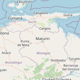
Map view of Cueva del Guácharo National Park

Use this park location map to pinpoint Cueva del Guácharo National Park in Venezuela, understand its exact geographic position, and read its mapped placement within the surrounding landscape more clearly.

Pigeon | © OpenStreetMap contributors

Location context for Cueva del Guácharo National Park

Monagas
Park atlas

Trace the regional spread of protected landscapes and compare park geography in the Cordillera de Caripe.

Explore Nearby National Parks and Protected Areas around Cueva del Guácharo National Park
Continue your exploration beyond Cueva del Guácharo National Park to discover other national parks and protected areas across Venezuela's mountainous Monagas state and surrounding regions. Compare their unique cave ecosystems, cloud forest habitats, and distinct limestone karst formations to understand the broader conservation landscape of the Cordillera de Caripe.
National parkSucre State

Turuépano National Park: National Park Protected Landscape and Geographic Context

Explore the mapped boundaries and natural terrain of Sucre State's national park.

Investigate Turuépano National Park, a protected national park situated within Sucre State, Venezuela. This entry provides detailed geographic context and information on its mapped protected-area boundaries, essential for understanding its role in the region's natural landscape atlas. Explore the specific terrain and protected land features that define this significant Venezuelan park.

Area
726 km²
Established
1991
IUCN
II
Relief
Lowland
National parkNueva Esparta

Cerro El Copey National Park: Mapped Protected Area in Nueva Esparta

Explore the geographic context and landscape of this national park.

Cerro El Copey National Park offers a distinct protected landscape within Nueva Esparta, Venezuela. This page details the park's geographic identity, its mapped boundaries, and its significance as a national park. Investigate the terrain and regional context to understand the protected area's ecological and geographical footprint, providing essential data for atlas-driven exploration.

Area
71 km²
Established
1974
IUCN
II
Relief
Mountain
National parkSucre

Península de Paria National Park: Venezuela's Protected Landscape Geography and Atlas Context

Explore mapped park boundaries and regional geographic setting.

Discover Península de Paria National Park, a vital protected area within the Sucre region of Venezuela. This page offers a detailed look at the park's geographic identity, focusing on its mapped boundaries and its significance as a national park for atlas-based exploration. Understand its landscape context and its contribution to Venezuela's network of protected lands, providing a clear geographic overview for researchers and explorers.

Area
375 km²
Established
1978
IUCN
II
Relief
Mountain
Watercolor painting of a lagoon surrounded by green vegetation and mountains in the background
National parkMiranda State

Laguna de Tacarigua National Park: Protected Area and Miranda State Geography

Mapped natural landscape and park boundaries in Venezuela.

Laguna de Tacarigua National Park is a designated national park offering critical protected landscape features within Miranda State. This park provides essential context for understanding Venezuela's protected areas, with a focus on its mapped boundaries and regional geographic setting. Dive into the atlas-style details to comprehend its place in the natural landscape.

Area
391 km²
Established
1974
IUCN
II
Relief
Lowland
National parkMiranda

Guatopo National Park: Venezuela's National Park Mapped Landscape Context

Discover Guatopo National Park's protected area geography.

Guatopo National Park represents a key protected natural landscape in Venezuela's Miranda region. This entry offers detailed geographic context, focusing on the park's mapped boundaries and its status as a national park. It is designed for users seeking structured information about protected areas, enabling a deeper understanding of natural landscapes and their regional distribution within an atlas framework. Explore the park's distinct protected-area identity and its place in the national geography.

Area
1,224.64 km²
Established
1958
IUCN
II
Relief
Mixed relief
National parkVenezuela

Caura National Park: Venezuela's Largest Protected Area in the Guianan Highlands

Mapped boundaries of an immense tropical rainforest basin.

Caura National Park represents Venezuela's most extensive protected territory, established in 2017 to encompass the vast Caura River basin. This national park preserves a critical tropical rainforest ecosystem within the Guianan Highlands, contributing significantly to the Orinoco River's watershed. Its creation is the result of long-standing conservation efforts aimed at protecting millions of hectares of biodiverse landscape, offering a unique opportunity for understanding the geographic scope and ecological importance of large-scale protected areas.

Area
75,340 km²
Established
2017
IUCN
II
Climate
Tropical
Watercolor painting showing a winding river flowing through a landscape with rolling hills in the background
National parkVenezuela

El Ávila National Park: Venezuela's Premier Coastal Mountain National Park Exploration

Discover diverse terrain, mapped boundaries, and unique geographic context.

El Ávila National Park offers an exceptional gateway into Venezuela's mountainous protected landscapes. This national park features a dramatic rise from the Caribbean coast into varied terrain, including unique cloud forest and alpine zones. Its mapped geography showcases steep slopes, deep ravines, and remarkable elevation changes, providing a significant atlas-style study of coastal mountain environments. Exploring El Ávila National Park reveals a vital natural barrier and a rich ecosystem supporting diverse flora and fauna, making it a key destination for understanding regional protected areas.

Area
819 km²
Established
1958
IUCN
II
Relief
Mountain
National parkVenezuela

Macarao National Park: Venezuela's National Park with Mapped Boundaries and Regional Atlas Context

Explore its protected landscape and geographic setting within South America.

Delve into Macarao National Park, a significant national park situated in Venezuela. This page offers an atlas-centric view of the park, detailing its mapped boundaries and highlighting its importance within the regional geography of northern South America. Understand how Macarao National Park contributes to the country's network of protected landscapes and provides foundational geographic context for explorers and researchers.

Area
150 km²
Established
1973
IUCN
II
Relief
Mountain

Common questions about visiting, size, designation, and location context for Cueva del Guácharo National Park

Cueva del Guácharo National Park FAQs for park facts, access, geography, and protected area context
Find quick answers about Cueva del Guácharo National Park, including protected-area facts, park geography, trail and visitor context, and how the park fits into its surrounding country and regional landscape.
MoriAtlas Explorer

Continue Your Protected Areas Search Across the Global Atlas

Deepen your exploration by continuing the structured search for national parks and protected areas worldwide. Utilize the comprehensive filtering capabilities to compare different conservation landscapes and refine your understanding of global park geography. Discover more about the distribution and characteristics of protected natural areas.

Global natural geography