

Mori Atlas logo
Protected areaDeen Maar Indigenous Protected Area

Mapping the cultural and natural intersection of limestone ridges, dunes, and Bass Strait coastal wetlands.

Deen Maar Indigenous Protected Area: A Coastal Geography of Gunditjmara Country in Victoria

Deen Maar Indigenous Protected Area represents a unique coastal landscape in south west Victoria, encompassing a diverse mosaic of limestone ridges, freshwater wetlands, and dune systems bounded by the Eumeralla River and Bass Strait. As the first declared Indigenous Protected Area in the state, this reserve integrates profound Aboriginal cultural heritage with vital bird conservation habitats. Visitors can analyze the compact topography and ecological layering that define this significant Gunditjmara land.

Aboriginal heritageIndigenous Protected Areacoastal reservewetlandslimestone ridgesdune systems

Deen Maar Indigenous Protected Area

Protected area

Park overview

Structured park overview, official facts, and landscape profile for Deen Maar Indigenous Protected Area

Deen Maar Indigenous Protected Area park facts, protected area profile, and essential visitor context

Review the core facts for Deen Maar Indigenous Protected Area, including designation, size, terrain, visitor scale, habitats, and operating context in one park-focused overview.

About Deen Maar Indigenous Protected Area

Deen Maar Indigenous Protected Area sits along the south-western Victorian coastline where the Eumeralla River meets Bass Strait. Although compact, the reserve occupies a striking meeting point of landforms. Limestone ridges, wetlands, lakes, and coastal dunes come together in a short stretch of shoreline, backed by the steady swell of the Southern Ocean and overlooked by the offshore island of Deen Maar, also known as Lady Julia Percy Island.

The IPA carries deep significance for Aboriginal people of the region. It lies on the traditional country of the Peek Whurrong speakers of the Dhauwurdwurung, who are part of the broader Gunditjmara nation. The Aboriginal history of this place extends well beyond the relatively recent declaration of the reserve. In 1842, Deen Maar was the site of conflict between Aboriginal people of the area and European colonists, an episode that became part of the Eumeralla Wars, a sustained struggle that continued across roughly two decades in the mid-19th century. Remains of people involved in that conflict remain at Deen Maar, adding a tangible ancestral layer to the landscape.

In the modern era, the land was purchased in 1993 by ATSIC for the Framlingham Aboriginal Trust, with the explicit intention that it would become an Indigenous Protected Area. That intention was realized in 1999 when the area was formally declared as an IPA, making Deen Maar the first such reserve in Victoria. The area's IUCN Category VI status indicates that Aboriginal ownership and management are central to its meaning. Beyond cultural stewardship, the IPA also plays an ecological role, sitting within the Yambuk Important Bird Area identified by BirdLife International for threatened species such as the orange-bellied parrot and the hooded plover.

Taken together, the cultural, historical, and ecological layers of Deen Maar create a protected landscape that is small in area but rich in meaning. The combination of Gunditjmara heritage, early colonial history, a varied coastal environment, and recognized bird conservation importance makes the IPA a distinctive entry in Australia's network of Indigenous Protected Areas.

Quick facts and research context for Deen Maar Indigenous Protected Area

Deen Maar Indigenous Protected Area is located in south-west Victoria, Australia, on land bounded by the Eumeralla River and Bass Strait, with Yambuk as the nearest town. Established as an Indigenous Protected Area on 8 November 1999, it was the first IPA declared in Victoria and is classified as an IUCN Category VI protected area, emphasizing sustainable use alongside conservation.

Protection and recognition

Review documented terrestrial protection scope and baseline administrative facts.

Deen Maar Indigenous Protected Area Protection Status and Scope

Deen Maar Indigenous Protected Area maintains a documented terrestrial protection scope within the global conservation registry. Structured records assemble verified management parameters and international recognition data for comprehensive geographic analysis.

Protection details

Protection scope
Terrestrial
Transboundary protection
No
Park context

Deeper park guide and search-rich context for Deen Maar Indigenous Protected Area

Deen Maar Indigenous Protected Area history, landscape, wildlife, and travel context

Explore Deen Maar Indigenous Protected Area through its history, landscape character, ecosystems, wildlife, conservation priorities, cultural context, and seasonal travel timing in a structured park guide built for atlas discovery and search intent.

Why Deen Maar Indigenous Protected Area stands out

Deen Maar is best known for being the first Indigenous Protected Area declared in Victoria and for its position at the interface between Aboriginal cultural heritage, a compact coastal landscape, and an internationally recognized bird conservation area. Its name itself reflects the cultural geography of Gunditjmara country, drawing directly from the offshore island of Deen Maar, or Lady Julia Percy Island, visible from the shore. The reserve is also known for the unusual concentration of habitats packed into its small footprint: limestone ridges, coastal wetlands, shallow lakes, and dune systems, all framed by Bass Strait and the Eumeralla River estuary. This combination of cultural significance, landscape diversity, and importance for threatened shorebirds and parrots gives the IPA a significance well beyond its modest size.

Deen Maar Indigenous Protected Area history and protected-area timeline

The landscape around Deen Maar has been part of Gunditjmara country, particularly the country of the Peek Whurrong speakers of the Dhauwurdwurung, for generations. In the mid-19th century this stretch of coast became a flashpoint in the wider history of Aboriginal and colonial contact in Victoria. In 1842, Deen Maar was the site of conflict between the Aboriginal people of the area and European colonists. This conflict is known as part of the Eumeralla Wars, a prolonged struggle between Aboriginal groups and settlers that continued for roughly twenty years. Physical remains of people involved in those events are still located at Deen Maar, embedding a difficult chapter of colonial history directly into the landscape.

In the late twentieth century, the site entered a new chapter as an expression of Aboriginal land management and self-determination. In 1993, the property was purchased by ATSIC on behalf of the Framlingham Aboriginal Trust, with the explicit intention that the land become an Indigenous Protected Area. That objective was formally achieved on 8 November 1999, when Deen Maar was declared as an Indigenous Protected Area, becoming the first IPA in Victoria. Its classification as an IUCN Category VI protected area reflects its character as a place where Aboriginal cultural values, long-term ecological conservation, and careful use of natural resources come together.

Deen Maar Indigenous Protected Area landscape and geographic character

Deen Maar occupies a narrow coastal strip where several contrasting terrains meet. Limestone ridges rise from the landscape, framing a system of wetlands and shallow lakes behind the dunes. The dunes themselves form a shifting barrier between the terrestrial environments and Bass Strait. Beyond the shore, the island of Deen Maar (Lady Julia Percy Island) sits offshore, giving the IPA its name and shaping the visual character of the coast.

The Eumeralla River defines one side of the reserve, while Bass Strait defines the other. This combination of river, wetland, dune, and ocean produces a compressed but unusually varied coastal landscape. The terrain is low-lying and shaped by the constant interplay of freshwater, saltwater, and wind, producing a mosaic of calcareous limestone, saturated ground, moving sand, and open water in close proximity to one another.

Deen Maar Indigenous Protected Area ecosystems, habitats, and plant life

Although Deen Maar covers only a few square kilometres, the combination of limestone ridges, freshwater wetlands, shallow lakes, dune systems, and adjacent ocean shoreline creates a layered ecological setting. The calcareous soils of the limestone ridges, the periodically flooded wetland basins, and the shifting sands of the coastal dunes support different plant and animal communities within a short distance of one another.

The IPA also sits within the Yambuk Important Bird Area, an area recognized by BirdLife International for its role in supporting threatened bird species. This designation reflects the importance of the broader mosaic of habitats, particularly the wetland and shoreline environments, for birds that depend on this stretch of south-west Victorian coast.

Deen Maar Indigenous Protected Area wildlife and species highlights

The IPA's wildlife values are closely tied to its birdlife. Because Deen Maar falls within the Yambuk Important Bird Area, it contributes to the protection of species that BirdLife International has identified as priorities for conservation. Among these are the orange-bellied parrot, one of Australia's most threatened parrots, which relies on coastal habitats in south-eastern Australia, and the hooded plover, a vulnerable shorebird that nests on sandy beaches.

The mix of wetlands, dunes, and shoreline provides feeding and roosting habitat for these and other waterbirds and shorebirds, while the limestone ridges, lakes, and native vegetation of the broader reserve support additional fauna typical of south-west Victorian coastal environments. The compact scale of the reserve means that even small adjustments to habitat quality at Deen Maar can be significant for local wildlife populations.

Deen Maar Indigenous Protected Area conservation status and protection priorities

Deen Maar's conservation significance operates on several levels. As an Indigenous Protected Area, it reflects a model of protected-area governance in which Aboriginal people are the primary custodians of land and culture together, rather than conservation being purely an external government exercise. Its IUCN Category VI designation indicates recognition of that approach, emphasizing sustainable use alongside conservation outcomes.

At the broader ecological level, the IPA lies within the Yambuk Important Bird Area, recognized by BirdLife International because of its importance for threatened species such as the orange-bellied parrot and the hooded plover. By contributing to the integrity of this larger bird area, Deen Maar plays a role in regional efforts to maintain habitat for some of Australia's most vulnerable bird species. Its position at the meeting of the Eumeralla River, wetland systems, and Bass Strait gives the conservation effort a stronger ecological reach than its modest area alone might suggest.

Deen Maar Indigenous Protected Area cultural meaning and human context

Deen Maar carries deep cultural meaning for Gunditjmara people. The land belongs to the Peek Whurrong speakers of the Dhauwurdwurung, and the IPA itself takes its name from the offshore island of Deen Maar, also called Lady Julia Percy Island, known in local tradition as 'this man here'. In the 1990s the site's purchase by ATSIC for the Framlingham Aboriginal Trust, and its later declaration as the first IPA in Victoria, marked a deliberate step by Aboriginal people to protect a place of both cultural and ecological significance under their own stewardship.

The landscape also preserves a difficult and layered colonial history. The events of 1842 at Deen Maar, part of the broader Eumeralla Wars, are not just background context: physical remains of people involved in those conflicts rest at the site. As a result, Deen Maar functions simultaneously as a place of continuing Aboriginal connection, a contested colonial history, and a contemporary example of Aboriginal-led land management.

Top sights and standout views in Deen Maar Indigenous Protected Area

Deen Maar stands out for the unusually rich layering of cultural, historical, and ecological values on a very small coastal reserve. The IPA is the first to be declared in Victoria, sits on Gunditjmara country with strong ties to Gunditjmara language and identity, and draws its name directly from the nearby island of Deen Maar, or Lady Julia Percy Island.

Ecologically, its inclusion in the Yambuk Important Bird Area places it within a network of habitat important for threatened species such as the orange-bellied parrot and the hooded plover. The combination of limestone ridges, wetlands, lakes, and dunes, all bounded by the Eumeralla River and Bass Strait, gives the protected area a striking physical character in a compact footprint.

Best time to visit Deen Maar Indigenous Protected Area

As a small coastal reserve on Bass Strait, Deen Maar reflects the broader seasonal rhythm of south-west Victoria. Cooler months typically bring changeable weather, stronger swell, and active storm shaping of the dunes and shoreline, while the warmer months tend to offer calmer conditions for walking along the beach and exploring the coastal flats. For visitors interested in shorebirds such as the hooded plover, the warmer months are often associated with nesting activity along sandy beaches, while the cooler months can be a time of greater movement and foraging by waterbirds in the wetlands. As with much of the south-west Victorian coast, visitors should expect weather to vary quickly and conditions to feel cooler and windier than inland areas at any time of year.
Monthly climate preview

Long-term monthly temperature and precipitation patterns recorded at a representative coordinate

Deen Maar Indigenous Protected Area Climate Normals and Annual Temperature Rhythm

Deen Maar Indigenous Protected Area records mean monthly temperatures ranging from 11.70 °C to 17.64 °C alongside varying daily precipitation levels between 1.07 mm and 3.03 mm per day. Examining the complete twelve-month climatological profile reveals detailed multi-year variations in temperature ranges and precipitation distribution.
Annual mean14 °C
12 °C18 °C
Jan17°
Feb18°
Mar17°
Apr15°
May14°
Jun12°
Jul12°
Aug12°
Sep12°
Oct13°
Nov15°
Dec16°
Warmest month
February

17.6 °C

Coolest month
August

11.7 °C

Wettest month
August

3 mm/day

Driest month
February

1.1 mm/day

Park location guide

Geography guide, regional context, and park location map for Deen Maar Indigenous Protected Area

Deen Maar Indigenous Protected Area park geography, regions, and map view in Australia

Understand where Deen Maar Indigenous Protected Area sits in Australia through a broader geographic reading of the surrounding landscape, nearby location context, and its mapped position within the national park landscape.

How Deen Maar Indigenous Protected Area fits into Australia

Australia is a constitutional monarchy and federal parliamentary democracy comprising six states and ten territories. With a population of nearly 28 million, it is one of the world's most urbanised countries, with most people concentrated on the eastern seaboard. The country has a high Human Development Index and is known for its cultural diversity, ancient Aboriginal heritage, and unique wildlife.

Wider geography shaping Deen Maar Indigenous Protected Area in Australia

Australia occupies the entire Australian continent, the island of Tasmania, and numerous smaller islands. It is the world's flattest and driest inhabited continent, featuring vast deserts in the interior (the Outback), tropical rainforests along the eastern coast, and a coastline bordering the Indian and Pacific Oceans.

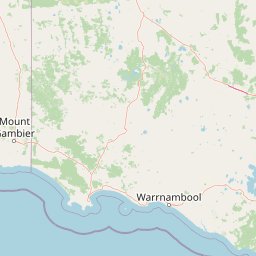
Map view of Deen Maar Indigenous Protected Area

Use this park location map to pinpoint Deen Maar Indigenous Protected Area in Australia, understand its exact geographic position, and read its mapped placement within the surrounding landscape more clearly.

Pigeon | © OpenStreetMap contributors

Location context for Deen Maar Indigenous Protected Area

Victoria
Park atlas

Compare regional protected areas and connected coastal ecosystems across south-west Victoria

Explore Parks Near Deen Maar Indigenous Protected Area And Surrounding Coastal Landscapes

Browse other parks near Deen Maar Indigenous Protected Area to examine similar coastal wetlands, limestone ridges, and protected habitats. Comparing adjacent conservation landscapes provides broader geographic context for regional wildlife corridors and coastal terrain.
National parkAustralia
About 24 km away#1 closest

Northwest

Budj Bim National Park: Ancient Volcanic Landscapes and World Heritage Protected Area

Explore the unique geography of Budj Bim National Park's crater lakes and lava tubes.

Budj Bim National Park offers an exceptional exploration of volcanic geography and ancient human ingenuity. This protected area features a dramatic landscape dominated by volcanic cones, lava tubes, and the picturesque Lake Surprise crater lake. Its significance is amplified by the presence of sophisticated Aboriginal aquaculture systems, developed thousands of years ago by the Gunditjmara people, which have contributed to its UNESCO World Heritage status. Discover the mapped terrain and protected land context of this geologically and culturally rich Australian national park.

Area
54.7 km²
Established
1960
IUCN
II
Relief
Mixed relief
A watercolor painting of a calm body of water bordered by gentle rolling green hills and sparse trees under a soft, light-filled sky.
Protected areaVictoria
About 30 km away#2 closest

Northwest

Budj Bim heritage areas: Mapped Volcanic Landscapes and Ancient Aquaculture Systems

Regional protected geography in Victoria, Australia

Budj Bim heritage areas encompass a complex volcanic terrain in south-western Victoria, featuring extensive stone channel networks and managed wetland systems. This protected landscape documents thousands of years of Gunditjmara land engineering, from the dormant Budj Bim crater to the diverse marshlands of Tyrendarra. Access detailed map context and geographical data on this vital cultural and geological site.

Area
99.35 km²
IUCN
VI
Relief
Upland
Climate
Temperate
National parkAustralia
About 30 km away#3 closest

Northwest

Mount Eccles National Park: Geographic Atlas of Volcanic Protected Landscapes

Explore mapped boundaries and regional park geography.

Delve into the structured geographic information for Mount Eccles National Park, a significant protected area in Victoria, Australia. This component of Budj Bim National Park showcases a distinct volcanic landscape and its surrounding terrain. Understand the park's mapped boundaries, regional setting, and its place within Australia's diverse protected land atlas, offering a clear view of its natural geography.

National parkBarwon South West
About 45 km away#4 closest

Northwest

Cobboboonee National Park: A Protected Landscape in Australia's Barwon South West Region

Explore its mapped geography and natural terrain.

Cobboboonee National Park represents an important protected area within the Barwon South West region of Australia. This destination offers users a deep dive into the park's specific geography, providing context on its mapped boundaries and the surrounding natural landscapes. It is designed for exploration of the park's protected-area identity and its place within the regional geography, offering structured data for landscape context.

Area
185.1 km²
Established
2008
IUCN
II
Climate
Temperate
National parkAustralia
About 52 km away#5 closest

West

Mount Richmond National Park: Protected Area Atlas and Southwest Victoria Landscape

Explore mapped terrain and coastal woodland ecosystems.

Mount Richmond National Park is a vital protected area in Victoria's southwest, safeguarding coastal woodland and heath remnants on the region's volcanic plains. As a component of Victoria's national park system, it provides a geographically specific example of a protected landscape, contributing to the regional atlas of natural environments. Its landscape character is defined by eucalyptus woodlands and coastal influences, offering context for understanding conservation corridors and the mapped natural terrain of the southwestern Victorian coast. The park’s inclusion in long-distance walking routes also underscores its value for exploring protected natural areas.

Area
17.33 km²
Established
1960
IUCN
II
Relief
Mixed relief
National parkAustralia
About 56 km away#6 closest

West

Discovery Bay Marine National Park: Victoria's Protected Coastal Marine Landscape

Mapped protected waters adjacent to Cape Bridgewater's unique geography.

Discover the geographic scope and protected landscape identity of Discovery Bay Marine National Park, an important marine national park located in Victoria, Australia, near Portland. This protected area safeguards a crucial stretch of the country's southern coastline, contributing to the ecological significance of the Southern Ocean marine region. Its position adjacent to the Discovery Bay Coastal Park highlights an integrated conservation approach, offering users a detailed view of its mapped marine boundaries and the distinctive geological context of the Cape Bridgewater area for atlas exploration.

Area
27.7 km²
Established
2002
IUCN
II
Climate
Temperate
National parkAustralia
About 59 km away#7 closest

Northwest

Lower Glenelg National Park: Dramatic River Gorge and Limestone Cave Protected Landscape

Explore its mapped boundaries and unique geological features.

Lower Glenelg National Park in Victoria, Australia, is a national park celebrated for its visually stunning Glenelg River gorge. This protected area showcases millions of years of geological history etched into its limestone cliffs and features the accessible Princess Margaret Rose Cave. Understand the park's mapped landscape, its diverse terrain from riverine woodlands to coastal wetlands, and its significance within regional geographic exploration.

Area
273 km²
Established
1969
IUCN
II
Visitors
200K annual
Protected areaVictoria
About 59 km away#8 closest

East

Framlingham Forest Indigenous Protected Area: Geography and Landscape Overview

Aboriginal-owned savanna woodlands in Western Victoria

Framlingham Forest Indigenous Protected Area is an important cultural and ecological site in south-western Victoria. Spanning over 1,100 hectares of stringybark and manna gum savannah, this protected area offers a unique glimpse into the native woodland ecosystems that once defined the Western District plains near the Hopkins River.

Area
11.3 km²
Established
2009
Relief
Lowland
Scope
Terrestrial

Common questions about visiting, size, designation, and location context for Deen Maar Indigenous Protected Area

Deen Maar Indigenous Protected Area FAQs for park facts, access, geography, and protected area context

Find quick answers about Deen Maar Indigenous Protected Area, including protected-area facts, park geography, trail and visitor context, and how the park fits into its surrounding country and regional landscape.
MoriAtlas Explorer

Continue Your Protected Areas Search Across the Global Atlas

Deepen your exploration by continuing the structured search for national parks and protected areas worldwide. Utilize the comprehensive filtering capabilities to compare different conservation landscapes and refine your understanding of global park geography. Discover more about the distribution and characteristics of protected natural areas.

Global natural geography