
Mori Atlas logo
Nature reserveDingel und Eberschützer Klippen

A regional ecological mosaic of calcareous grasslands, orchid-rich beech forests, and limestone slopes.

Dingel und Eberschützer Klippen Nature Reserve: Mapped Protected Landscapes in Northern Hesse

Dingel und Eberschützer Klippen represents a significant protected area in northern Hesse, Germany, nestled within the broader topography of the Naturpark Reinhardswald. The landscape is defined by a diverse mosaic of near-natural deciduous woodland and species-rich calcareous semi-dry grassland, shaped by limestone geology and historical grazing management. Discover the ecological patterns of this Natura 2000 site through mapped terrain features and protected habitat units.

beech forestcalcareous grasslandorchidshabitat restorationnature reserveFFH site
Stylized digital illustration of a rolling landscape with green hills, deciduous trees, a winding dirt path, and a small waterfall flowing from a cliffside under a soft, pale sky.

Dingel und Eberschützer Klippen

Nature reserve

Park overview

Structured park overview, official facts, and landscape profile for Dingel und Eberschützer Klippen

Dingel und Eberschützer Klippen park facts, protected area profile, and essential visitor context

Review the core facts for Dingel und Eberschützer Klippen, including designation, size, terrain, visitor scale, habitats, and operating context in one park-focused overview.

About Dingel und Eberschützer Klippen

Dingel und Eberschützer Klippen protects a continuous tract of near-natural broadleaf forest and calcareous semi-dry grassland on limestone substrate just north of Hofgeismar in northern Hesse. The site lies within the larger Naturpark Reinhardswald, a protected landscape that spans a significant chunk of the forested uplands between the Diemel and Weser river valleys. Within this regional setting, the reserve forms a compact but ecologically rich area where woodland, open meadow, and shrub-edge habitats meet in close proximity.

The woodland component comprises large stands of European beech (Rotbuche) as the dominant species, often forming the characteristic Waldmeister-Buchenwald and Orchideen-Buchenwald associations. These forests are noteworthy for their structural diversity and their rich herbaceous layer, with species such as wild garlic, hollow larkspur, yellow wood anemone, Turk's cap lily, and bird's-nest orchid. The associated canopy includes sessile oak, hornbeam, sycamore maple, field maple, small-leaved lime, wych elm, and wild service tree, contributing to a multi-layered vertical forest profile.

The open calcareous grassland areas, locally known as Kalkhalbtrockenrasen, are perhaps the most ecologically distinctive element of the protected landscape. These were historically maintained by grazing with sheep, goats, and cattle, and after decades of abandonment and partial afforestation with spruce, restoration work has re-established open, flower-rich meadow communities on the south-facing slopes of the Dingel. Juniper shrubs punctuate the grassland mosaic, while characteristic meadow species such as cross gentian and cat's-foot add seasonal colour. A documented flora of 359 vascular plant species, 49 bryophyte species, and 8 lichen species underscores the site's botanical significance, and the calcareous grasslands support a rich butterfly fauna of at least 46 species, including many classified as at least vulnerable in Hesse.

Quick facts and research context for Dingel und Eberschützer Klippen

Dingel und Eberschützer Klippen is a combined nature reserve (Naturschutzgebiet), landscape protection area (Landschaftsschutzgebiet), and FFH/Natura 2000 site in the Landkreis Kassel, Hesse, Germany, situated north of Hofgeismar within the Naturpark Reinhardswald. The nature reserve covers approximately 112 hectares, while the adjoining landscape protection area adds around 35 hectares; together they form a continuous protected complex. The corresponding FFH site is about 118 hectares in size, with elevations ranging roughly from 160 m to 260 m above sea level. The area was legally designated as a nature reserve on 22 December 1987, replacing an older 1938 ordinance for the protection of landscape components and parts.

Protection and recognition

Examining terrestrial conservation boundaries and official designation records for the protected area.

Dingel und Eberschützer Klippen Protection Status and Natura 2000 Recognition

Dingel und Eberschützer Klippen maintains a documented terrestrial protection status supported by official Natura 2000 recognition records. Structured database entries organize conservation boundaries and management scopes for regional atlas analysis.

International recognition

Protection details

Protection scope
Terrestrial
Transboundary protection
No
WDPA ID
162757
Park context

Deeper park guide and search-rich context for Dingel und Eberschützer Klippen

Dingel und Eberschützer Klippen history, landscape, wildlife, and travel context

Explore Dingel und Eberschützer Klippen through its history, landscape character, ecosystems, wildlife, conservation priorities, cultural context, and seasonal travel timing in a structured park guide built for atlas discovery and search intent.

Why Dingel und Eberschützer Klippen stands out

The area is best known for its species-rich calcareous semi-dry grasslands interspersed with juniper stands, and for its beech forest communities of the woodruff and orchid beechwood types. The south-facing slopes of the Dingel hill, in particular, host an exceptional concentration of terrestrial orchids, including several orchid species rarely seen together in such a small area. The combination of calcareous grassland, near-natural broadleaf forest, and traditional cultural landscape management gives the site a distinctive ecological profile within northern Hesse.
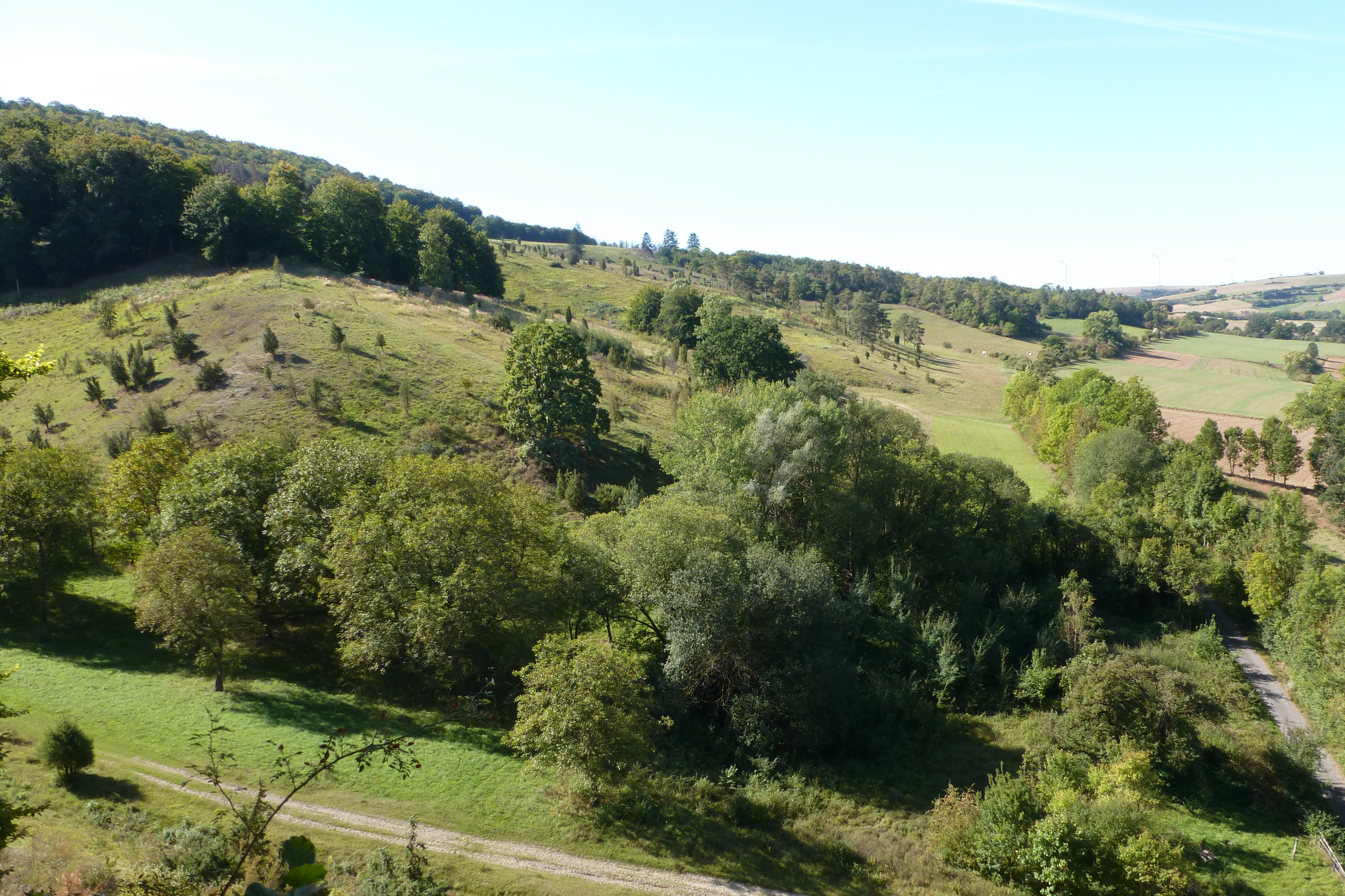
A wide angle view of a rolling green landscape in Hesse, Germany, featuring scattered trees, patches of forest, and grassy slopes under a clear blue sky.
A view of the landscape at Dingel und Eberschützer Klippen nature reserve, showcasing the mix of deciduous forest and open grasslands.

Dingel und Eberschützer Klippen history and protected-area timeline

The protected status of Dingel und Eberschützer Klippen was formally established on 22 December 1987, when the area was designated as both a nature reserve and an adjoining landscape protection area. This designation replaced an older 1938 ordinance for the protection of landscape components and landscape parts, updating the legal framework to modern nature conservation standards. The two protected zones, the Naturschutzgebiet and the Landschaftsschutzgebiet, adjoin one another directly and together form an integrated conservation landscape.

The site's ecological history, however, stretches back much further, shaped by centuries of traditional land use. The open calcareous grasslands were created and maintained by historical grazing with sheep, goats, and cattle. Beginning in the 1950s, this pastoral use was largely discontinued, allowing shrubs to colonise the meadows and prompting partial afforestation with spruce. After the 1987 designation, management actions focused on clearing shrubs from former grassland areas and reintroducing grazing, which allowed the open, orchid-rich Kalkhalbtrockenrasen communities to gradually recover, especially on the south-facing slopes of the Dingel.

The site is also documented in Hessian FFH management planning, with a formal management plan and a 2004 baseline data report prepared for the equal-area Natura 2000 site. Earlier scientific attention to the area's dry grasslands is documented in regional natural history publications from the mid-1980s, indicating that the Dingel hills have been recognised as a conservation priority for several decades before formal Natura 2000 protection reinforced their status.

Dingel und Eberschützer Klippen landscape and geographic character

The landscape of Dingel und Eberschützer Klippen is shaped by gently sloping limestone uplands and the contrasting deep-cut Diemel river valley just to the north. Elevations within and around the reserve range from roughly 160 m to 260 m above sea level, producing a subtle but ecologically meaningful relief that influences light, soil depth, and vegetation patterns. The Dingel hill forms an elevated plateau within the reserve, while the Eberschütz area contributes further cliff and slope exposures toward the Diemel.

The terrain is characterised by south-facing slopes with thin, calcareous soils, alternating with more level plateau surfaces and broader forest slopes. These topographic contrasts create a mosaic of microhabitats: warm, dry, sun-exposed slopes favour open calcareous grassland and juniper stands, while shaded, deeper-soil woodland areas support beech forest communities with a richly developed herb layer. The plateau of the Dingel is occupied in part by a glider airfield, surrounded on three sides by the reserve, adding a notable anthropogenic feature within the otherwise natural mosaic.

The northern edge of the protected area borders the Diemel valley, where the Kassel–Warburg railway line runs along the valley floor. Surrounding land use is a mix of additional woodland communities and agricultural fields, providing a transitional buffer between the intensively managed open habitats of the reserve and the wider Hessian cultural landscape. Several marked hiking trails traverse the area, including a section of the Diemeltaler Schmetterlings-Steig (Diemel valley butterfly trail), linking the landscape to a broader regional trail network.

Dingel und Eberschützer Klippen ecosystems, habitats, and plant life

Ecologically, Dingel und Eberschützer Klippen is defined by the interplay between two contrasting yet closely juxtaposed habitat types: near-natural, species-rich broadleaf forest and open calcareous semi-dry grassland. The forest component is dominated by European beech, with structural and species diversity enhanced by the presence of oak, hornbeam, sycamore, lime, elm, and wild service tree. These mixed broadleaf stands form woodruff beechwood (Waldmeister-Buchenwald) and orchid beechwood (Orchideen-Buchenwald) communities, both of national conservation relevance.

The grassland component, especially on south-facing slopes, supports a calcareous flora rich in orchids, gentians, and other characteristic dry-meadow species. Juniper stands punctuate the open landscape, providing structural variation and supporting shrub-edge species. Documented botanical diversity includes 359 vascular plant species, 49 bryophyte species, and 8 lichen species, an unusually high tally for a relatively compact Hessian reserve, reflecting both habitat diversity and careful long-term management.

The site's ecological identity is closely tied to its calcareous substrate and the traditional open-landscape management that has shaped its grassland communities. Restoration of these open habitats has been a key conservation task since the late twentieth century, with shrub clearance and reintroduced grazing allowing orchid-rich dry grassland to recover on formerly abandoned and afforested slopes. The combination of habitat diversity, calcareous geology, and management-oriented conservation makes the reserve an important reference site for orchid and butterfly conservation in northern Hesse.

Dingel und Eberschützer Klippen wildlife and species highlights

The fauna of Dingel und Eberschützer Klippen is particularly notable for its rich butterfly fauna, with at least 46 day-flying butterfly species recorded, many of which are classified as at least vulnerable in the Hessian Red List. The calcareous semi-dry grasslands provide essential habitat for these species, including both habitat specialists and generalists that benefit from the warm, flower-rich microclimate of south-facing slopes.

The reserve is also documented as habitat for several reptile species, including the smooth snake (Schlingnatter), the slow worm (Blindschleiche), the common wall lizard (Zauneidechse), and the viviparous lizard (Bergeidechse). These species benefit from the combination of open grassland, edge habitats, juniper shrub patches, and adjacent woodland edges, which together provide basking sites, shelter, and a broad prey base.

While the site's wildlife profile is defined primarily by its invertebrates and herpetofauna, the broader landscape mosaic of forest, open grassland, scrub, and edge habitats supports a typical array of central German woodland and farmland-edge fauna. The botanical richness of the herb layer and the structural diversity of the vegetation contribute to a relatively dense and varied food web, especially for pollinators and predators that depend on the calcareous grassland communities.

Dingel und Eberschützer Klippen conservation status and protection priorities

Dingel und Eberschützer Klippen is significant from a conservation perspective as a multi-layered protected site, combining national nature reserve status, landscape protection area status, and European Natura 2000 (FFH) designation under the EU Habitats Directive. The site contributes directly to the protection of habitat types that are priorities at both the Hessian and European level, particularly calcareous beech forest (Waldmeister- and Orchideen-Buchenwald) and calcareous semi-dry grasslands, both of which host rare orchid species and threatened butterfly communities.

A central conservation task at the site is the restoration and maintenance of the open calcareous grassland habitat, which degraded after grazing was abandoned in the mid-twentieth century and was partly replaced by spruce plantations. Following the 1987 designation as a nature reserve, restoration measures have included shrub clearance (Entkusselung) and the reintroduction of grazing, allowing orchid-rich dry meadow communities to recover on formerly abandoned and afforested slopes, especially on the south-facing exposures of the Dingel.

Management planning for the FFH site is overseen by the Regierungspräsidium Kassel, with formal management plans and baseline ecological assessments prepared for the area. The combination of habitat restoration, ongoing grazing management, and integration into the Naturpark Reinhardswald positions the reserve as a working model of how traditional cultural landscapes can be revived for biodiversity conservation in central Germany.

Dingel und Eberschützer Klippen cultural meaning and human context

The cultural context of Dingel und Eberschützer Klippen is closely tied to the long history of transhumance and small-scale pastoral farming in the Reinhardswald region. The open calcareous grasslands of the reserve were created and maintained over centuries by grazing with sheep, goats, and cattle, a form of land use that shaped much of northern Hesse's upland landscape. Where grazing was abandoned in the twentieth century, the cultural landscape gradually closed over and began to lose its distinctive ecological identity. The reserve can be read as a place where this older cultural relationship with the landscape is being consciously revived for conservation purposes, rather than as a wilderness in the strict sense.

Top sights and standout views in Dingel und Eberschützer Klippen

Dingel und Eberschützer Klippen stands out as a compact, multi-habitat reserve defined by calcareous geology, near-natural beech forest, and orchid-rich dry grassland on south-facing slopes. Its combination of woodruff and orchid beechwood communities, juniper-studded Kalkhalbtrockenrasen, and recovered grazing meadows makes it a regionally important reference area for orchid and butterfly conservation in northern Hesse. The site's integrated status as nature reserve, landscape protection area, and FFH area, combined with active restoration of former grazing lands, gives it a strong identity as a working cultural landscape turned conservation priority within the larger Naturpark Reinhardswald.

Best time to visit Dingel und Eberschützer Klippen

Late spring into early summer is generally the most rewarding period to experience Dingel und Eberschützer Klippen at its floristic peak, when the calcareous slopes host their richest display of orchids, gentians, and other dry-meadow flowers, and broadleaf forest layers are in full leaf. Summer brings continued butterfly activity across the open grasslands, while autumn offers colour in the beech forests and a quieter, milder atmosphere for walking. Winter visits can be attractive for observing the open structural mosaic of juniper, grassland, and forest edge in a tranquil, leafless state. Conditions can vary year to year, and visitors interested in peak orchid displays may benefit from consulting local sources closer to the season.

Monthly climate preview

Long-term representative point measurements for temperature and precipitation patterns

Dingel und Eberschützer Klippen Climate Normals and Annual Temperature Rhythm

Representative point records capture the measured annual temperature progression and monthly precipitation rhythm across standard climatology intervals at Dingel und Eberschützer Klippen. Detailed monthly climate normals provide broader context for studying long-term weather patterns at this protected location in Hesse.
Annual mean8 °C
-1 °C18 °C
Jan-1°
Feb
Mar
Apr
May12°
Jun16°
Jul18°
Aug18°
Sep14°
Oct
Nov
Dec
Warmest month
July

18 °C

Coolest month
January

-0.6 °C

Wettest month
July

2.5 mm/day

Driest month
April

1.5 mm/day

Park location guide

Geography guide, regional context, and park location map for Dingel und Eberschützer Klippen

Dingel und Eberschützer Klippen park geography, regions, and map view in Germany

Understand where Dingel und Eberschützer Klippen sits in Germany through a broader geographic reading of the surrounding landscape, nearby location context, and its mapped position within the national park landscape.

How Dingel und Eberschützer Klippen fits into Germany

Germany is a federal republic in Western and Central Europe with a population of over 83 million across sixteen constituent states. It is Europe's largest economy by nominal GDP and a major global exporter and importer. The capital is Berlin, and the country borders Denmark, Poland, Czech Republic, Austria, Switzerland, France, Luxembourg, Belgium, and the Netherlands.

Wider geography shaping Dingel und Eberschützer Klippen in Germany

Germany is located in Western and Central Europe, spanning 357,022 km². It borders Denmark to the north, Poland and the Czech Republic to the east, Austria and Switzerland to the south, and France, Luxembourg, Belgium, and the Netherlands to the west. The country has coastlines on the Baltic Sea and North Sea to the north, with the Alps located in the southern region.

Map view of Dingel und Eberschützer Klippen

Use this park location map to pinpoint Dingel und Eberschützer Klippen in Germany, understand its exact geographic position, and read its mapped placement within the surrounding landscape more clearly.

Pigeon | © OpenStreetMap contributors

Location context for Dingel und Eberschützer Klippen

Hesse

Visual exploration of limestone slopes, beech forests, and calcareous habitats

Dingel und Eberschützer Klippen Photos and Protected Area Landscapes

Visual records capture the topography, vegetation mosaics, and ecological features defining Dingel und Eberschützer Klippen. Detailed photography provides clear insight into the protected terrain, woodland boundaries, and rare grassland habitats spanning northern Hesse.

A wide angle view of a rolling green landscape in Hesse, Germany, featuring scattered trees, patches of forest, and grassy slopes under a clear blue sky.

Park atlas

Compare nearby regional landscapes, upland forests, and protected natural reserves in northern Hesse

Explore Other Parks Near Dingel und Eberschützer Klippen and Surrounding Protected Areas

Browse protected areas and natural reserves situated near Dingel und Eberschützer Klippen to compare regional forest types and limestone terrain. Continuing through adjacent conservation landscapes reveals broader ecological patterns across the surrounding Hessian uplands.
A soft watercolor painting showing a winding river flowing through a green meadow with rolling hills and distant forested ridges under a pale, warm sky.
Nature reserveLandkreis Kassel
0.3 km away#1 closest

West

Kalkmagerrasen und Diemelaltwasser bei Lamerden Nature Reserve and Landscape Overview

A rare protected mosaic in the Landkreis Kassel district

Investigate the distinctive geography of Kalkmagerrasen und Diemelaltwasser bei Lamerden, where shell limestone slopes rise above the Diemel river oxbow. This protected habitat complex serves as an important ecological anchor in northern Germany, preserving the delicate balance between riparian flood zones and orchid-rich calcareous grasslands that define this regional landscape.

Area
0.175 km²
Established
1989
Relief
Upland
Climate
Temperate
A soft watercolor illustration showing rolling green hills, small groups of conifer trees, and a pale pink and peach sky in the background.
Natural monumentEberschütz
0.7 km away#2 closest

Northwest

Der Bunte Berg bei Eberschütz: Natural Monument and Landscape Geography

Limestone ridge and calcareous grassland habitat in Germany

Examine the topography and protected land features of Der Bunte Berg bei Eberschütz. This compact reserve provides a critical study of limestone-influenced terrain, transitioning from mature pine and beech woodland to specialized juniper heath and dry grassland habitats essential for regional biodiversity.

A watercolor painting showing a rolling landscape with sparse trees on the left, a grassy slope rising to a small forest on the right, and distant hills under a pale, soft sky.
Nature reserveLandkreis Kassel
2.6 km away#3 closest

Southwest

Ostheimer Hute Nature Reserve: Protected Calcareous Grassland Landscapes in Landkreis Kassel

A preserved limestone slope habitat in northern Hesse

Ostheimer Hute is a protected nature reserve characterized by species-rich calcareous dry grasslands on Triassic Muschelkalk limestone. Located within the Diemel Valley, this site preserves a traditional open landscape through managed grazing, supporting diverse invertebrate fauna and specialized flora across its distinct hill-slope parcels.

Area
0.162 km²
Established
1989
Relief
Upland
Climate
Temperate
A soft watercolor painting of rolling green and yellow hills under a clear sky, featuring sparse shrubbery and a gentle, layered horizon.
Nature reserveHessen
4.1 km away#4 closest

South

Mittelberg bei Hofgeismar: Nature Reserve and Protected Calcareous Grassland Site

A high-quality conservation landscape located in northern Hessen, Germany.

This nature reserve protects an ecologically rich slope habitat west of Hofgeismar. Defined by its sun-exposed calcareous soil and dry grassland, the site supports ten orchid species and a diverse assemblage of Red List butterflies. It stands as a textbook example of a small, high-density biodiversity hotspot embedded within the broader agricultural geography of the Kassel district.

Area
0.432 km²
Established
1991
Relief
Upland
Climate
Temperate
A soft watercolor painting of gentle green rolling hills and meadows under a faint pink sky.
Nature reserveHesse
4.7 km away#5 closest

North

Flohrberg und Ohmsberg bei Deisel Nature Reserve; Calcareous Landscape and Park Boundaries

A protected Hessian site near Trendelburg

Situated in the Landkreis Kassel, Flohrberg und Ohmsberg bei Deisel encompasses 107 hectares of calcareous ground, disused quarries, and sheep-grazed grasslands. The area provides a critical landscape context for orchid-rich flora and rare butterfly fauna within the northern Hessian hill country, acting as a protected link between open farmland and the Reinhardswald forest edge.

Area
0.418 km²
Established
1990
Nature reserveHesse
About 6.7 km away#6 closest

South

Kelzer Teiche Nature Reserve: Mapped Geography and Protected Wetland Boundaries in Hesse

A historic managed fishpond landscape in the Kassel region of northern Germany.

Kelzer Teiche encompasses 18.5 hectares of lowland countryside defined by its twin fishponds and fringe habitats. This nature reserve plays a recognizable role in the regional network of protected sites in Hesse, offering essential shelter for reed dwelling and migratory birds within a broader agricultural setting.

Area
0.185 km²
Established
1977
Water
Major water bodies
A watercolor painting showing a soft, panoramic view of rolling green hills, lush vegetation, and water, with a light and airy artistic style.
Nature reserveHesse
About 7.4 km away#7 closest

South

Meßhagen bei Niedermeiser Nature Reserve: Protected Landscape and Regional Geography

A mapped conservation site in the woodlands of Northern Hesse

Meßhagen bei Niedermeiser represents a key nature reserve in Northern Hesse, characterized by its transition between old beech forest and managed calcareous grasslands. This protected area, part of the wider Kelzer Holz network, provides a study in managed habitat succession, where meadow flora and invertebrate populations thrive in the intersection of open terrain and dense woodland edges.

Area
0.546 km²
Established
1996
Relief
Upland
Climate
Temperate
Protected landscapeHessen
About 11 km away#8 closest

East

Naturpark Reinhardswald: A Comprehensive Protected Landscape Atlas for Northern Hessen

Mapping forest ecosystems and limestone river valleys

Naturpark Reinhardswald protects a diverse mosaic of environments across northern Hessen, characterized by the contrast between extensive sandstone-dominated forests and open limestone grasslands. The terrain features historic woodland pastures, basalt outcrops, and riverine floodplains, providing a significant regional network of nature reserves and protected areas that represent both upland forest and valley ecosystems.

Area
448.51 km²
Established
2017
Relief
Mixed relief
Scope
Terrestrial

Common questions about visiting, size, designation, and location context for Dingel und Eberschützer Klippen

Dingel und Eberschützer Klippen FAQs for park facts, access, geography, and protected area context

Find quick answers about Dingel und Eberschützer Klippen, including protected-area facts, park geography, trail and visitor context, and how the park fits into its surrounding country and regional landscape.
MoriAtlas Explorer

Continue Your Protected Areas Search Across the Global Atlas

Deepen your exploration by continuing the structured search for national parks and protected areas worldwide. Utilize the comprehensive filtering capabilities to compare different conservation landscapes and refine your understanding of global park geography. Discover more about the distribution and characteristics of protected natural areas.

Global natural geography