Mori Atlas logo
National parkDoi Pha Hom Pok National Park

Discover the mapped boundaries and natural terrain of this national park in Thailand's northern highlands.

Doi Pha Hom Pok National Park: Protected Landscape and Regional Geography in Chiang Mai Province

Doi Pha Hom Pok National Park is a significant protected area located within the mountainous terrain of Chiang Mai Province, Thailand. As a national park, it offers valuable insight into the region's natural landscapes and geographic context. This page serves as a dedicated entry point for exploring the park's mapped boundaries and understanding its position within the broader Thai highlands, facilitating detailed atlas-style discovery of its protected landscape.

Mountain Protected AreaBirdwatching DestinationHot SpringsCloud ForestNorthern ThailandTropical Cloud Forest

Doi Pha Hom Pok National Park

National park

Park overview

Structured park overview, official facts, and landscape profile for Doi Pha Hom Pok National Park

Doi Pha Hom Pok National Park park facts, protected area profile, and essential visitor context
Review the core facts for Doi Pha Hom Pok National Park, including designation, size, terrain, visitor scale, habitats, and operating context in one park-focused overview.

About Doi Pha Hom Pok National Park

Doi Pha Hom Pok National Park occupies a remarkable position as Thailand's northernmost protected area, spanning the mountainous terrain where Thailand meets Myanmar. The park's 524-square-kilometer expanse sits within the Daen Lao Range, a north-south running mountain system that creates dramatic topography and ecological diversity. The landscape transitions dramatically from lowland valleys at 400 meters elevation to the granite summit plain at 2,285 meters, the second-highest point in Thailand. This elevation gradient supports three distinct forest types: hill evergreen cloud forest dominates the summit and upper slopes, coniferous forests clothe the ridges, and mixed deciduous forest fills the lower elevations. The park's location at the intersection of tropical and Himalayan biogeographic zones explains its remarkable species diversity. Beyond its ecological significance, the park serves as a critical watershed, with the Fang River and numerous tributaries originating from its highland forests, providing essential water resources for the surrounding agricultural communities. The Fang Hot Springs represent another significant resource, a 10-rai geothermal area where superheated mineral waters emerge from the earth, offering both scientific interest and visitor recreation.

Quick facts and research context for Doi Pha Hom Pok National Park

Doi Pha Hom Pok National Park covers 524 square kilometers in Chiang Mai Province, Thailand, established as the country's 97th national park. The park's namesake peak reaches 2,285 meters, making it Thailand's second-highest mountain after Doi Inthanon. The Fang Hot Springs area contains over 50 hot springs with water temperatures ranging from 90 to 130 degrees Celsius. Doi Lang within the park is recognized as one of Thailand's premier birdwatching sites, with more than 340 recorded bird species. The park was originally designated as Mae Fang National Park in 1968 and renamed Doi Pha Hom Pok in 2006.

Park context

Deeper park guide and search-rich context for Doi Pha Hom Pok National Park

Doi Pha Hom Pok National Park history, landscape, wildlife, and travel context
Explore Doi Pha Hom Pok National Park through its history, landscape character, ecosystems, wildlife, conservation priorities, cultural context, and seasonal travel timing in a structured park guide built for atlas discovery and search intent.

Why Doi Pha Hom Pok National Park stands out

Doi Pha Hom Pok is best known for two distinctive features: its geothermal hot springs and its exceptional high-altitude biodiversity. The Fang Hot Springs produce Thailand's highest-temperature natural hot springs, with some reaching 130 degrees Celsius and creating dramatic steam eruptions rising 40 to 50 meters. The park's Doi Lang area has become legendary among ornithologists, hosting over 340 bird species including rare Himalayan residents such as the Black-Throated Bushtit, Himalayan Cutia, and Spot-Breasted Laughing Thrush. The summit trek to Doi Pha Hom Pok offers panoramic sunrise views over a sea of clouds, particularly spectacular during the cool winter months when the mountain is often shrouded in fog.

Doi Pha Hom Pok National Park history and protected-area timeline

Doi Pha Hom Pok National Park was originally established in 1968 as Thailand's 97th national park under the name Mae Fang National Park. The original designation reflected the park's geographic position within the Fang Basin National Reserved Forest in Chiang Mai Province, encompassing the three districts of Mae Ai, Fang, and Chaiprakarn. For decades, the park operated under this name, protecting the significant natural resources of the Daen Lao Range. On March 14, 2006, the park was officially renamed Doi Pha Hom Pok National Park, adopting the name of its most famous tourist attraction and highest peak. This name change brought the park's institutional identity into alignment with its primary geographic feature and helped strengthen its connection to local identity and tourism promotion. The formal establishment declaration appeared in the Royal Gazette on September 4, 2000, solidifying its legal protected status within Thailand's national park system.

Doi Pha Hom Pok National Park landscape and geographic character

The landscape of Doi Pha Hom Pok National Park is dominated by the rugged terrain of the Daen Lao Range, a complex mountain system running north-south along the Thailand-Myanmar border. The park's topography features steep ridges, deep valleys, and dramatic elevation changes that create diverse microclimates and habitats. The namesake peak, Doi Pha Hom Pok, rises as a granite plain at 2,285 meters, often shrouded in persistent fog and experiencing cool temperatures year-round. Other significant peaks include Doi Pu Muen and Doi Laem, contributing to the park's mountainous character. The higher elevations feature exposed rock and the characteristic stunted vegetation of cloud forest, while the slopes below support dense pine forests and mixed deciduous woodland. The Fang River originates within the park boundaries, fed by numerous streams that cascade down the mountain slopes, making this landscape a vital hydrological source for the entire region.

Doi Pha Hom Pok National Park ecosystems, habitats, and plant life

The ecological character of Doi Pha Hom Pok is defined by its position at the crossroads of tropical Southeast Asian and Himalayan biogeographic provinces. The park's three forest zones reflect this transitional position: hill evergreen cloud forest crowns the summit and upper slopes, characterized by constant moisture, epiphytic vegetation, and stunted trees adapted to persistent mist; coniferous forest dominates the ridges where pines form pure stands on exposed slopes; and mixed deciduous forest occupies the lower valleys and foothills. The forest composition includes the valuable Hopea odorata tree species, while rare plant species such as Impatiens jurpioides inhabit the summit areas. Seasonal highlights include the Wild Himalayan Cherry, which blooms during the appropriate season, and the local Rhododendron known as Kulap Fi. The interaction between tropical and temperate species in this elevated landscape creates a unique ecological tapestry found nowhere else in Thailand.

Doi Pha Hom Pok National Park wildlife and species highlights

Doi Pha Hom Pok supports exceptional wildlife diversity, particularly notable for its avian population and invertebrate communities. The park records over 340 bird species, making it one of Thailand's most important birding destinations. The avifauna includes Himalayan residents such as the Black-Throated Bushtit, Himalayan Cutia, Spot-Breasted Laughing Thrush, and winter visitors including the Scaly Thrush and Chestnut Thrush. The endangered Giant Nuthatch, a species of global conservation concern, maintains a habitat within the park's forests. Mammalian residents include the Yellow-Throated Marten, Asiatic Black Bear, and Barking Deer, though these species are elusive and rarely encountered by visitors. The invertebrate fauna is equally remarkable, with rare butterflies including the Kaiser-i-Hind, Brown Gorgon, and Golden Birdwing. The Himalayan Giant Honey Bee has been scientifically confirmed in the summit area, representing another significant species record for the park.

Doi Pha Hom Pok National Park conservation status and protection priorities

Doi Pha Hom Pok National Park represents a critical conservation area in mainland Southeast Asia, protecting a significant portion of the Daen Lao Range ecosystem and serving as a corridor for species movement between Thailand and Myanmar. The park's elevation gradient and position at the intersection of biogeographic provinces create a biodiversity hotspot that supports species found nowhere else in Thailand. The hill evergreen forests play an essential role in watershed protection, capturing moisture from passing clouds and regulating water flow to downstream communities. As the second-highest protected peak in Thailand, the park preserves important high-altitude habitats that are increasingly vulnerable to climate change. The exceptional bird diversity at Doi Lang has attracted international attention, making the park a priority for ornithological conservation and sustainable tourism development that supports both protection and community benefits.

Doi Pha Hom Pok National Park cultural meaning and human context

While Doi Pha Hom Pok is primarily valued for its natural resources, the park exists within a cultural landscape shaped by the communities of northern Thailand. The park boundaries encompass forest areas traditionally used by local communities in the Fang, Mae Ai, and Chai Prakan districts. The Fang Hot Springs have long been a destination for local residents seeking the therapeutic benefits of mineral bathing, a tradition that continues today alongside the park's development as an ecotourism destination. The park's name derives from Doi Pha Hom Pok mountain, reflecting the importance of place-based identity in regional culture. The mountain's significance as the second-highest in Thailand adds to its cultural stature within the country.

Top sights and standout views in Doi Pha Hom Pok National Park

The Fang Hot Springs stand as the park's most accessible attraction, a geothermal area where superheated mineral waters emerge from the earth at temperatures reaching 130 degrees Celsius, creating spectacular steam plumes visible from the visitor center. The summit trek to Doi Pha Hom Pok rewards hikers with panoramic views and the famous sea of clouds phenomenon, best witnessed during the cool dry season from November through February. Doi Lang has earned its reputation as Thailand's birdwatching capital, where patient observers can spot species rarely found elsewhere in the country including the Himalayan Cutia and various laughingthrushes. The contrasting forest types, from cloud forest to pine woodland, create visual diversity across short hiking distances, while the seasonal cherry blossoms and rhododendron flowers add color to the mountain landscape.

Best time to visit Doi Pha Hom Pok National Park

The optimal time to visit Doi Pha Hom Pok depends on interests, though the cool dry season from November to February offers the most comfortable conditions for trekking and wildlife viewing. Daytime temperatures on the summit can approach freezing during these months, but the clear skies provide the best visibility for sunrise views over the sea of clouds. Birdwatchers particularly favor the period from November to March when migratory species from the Himalayas join the resident avifauna. The hot springs can be enjoyed year-round, though the cooler months make the warm waters more pleasant for extended bathing. The rainy season from May to September brings heavy rainfall that can make trails slippery and access difficult, though the refreshed forest greenery and lower visitor numbers appeal to some travelers. March and April represent the hottest period, with temperatures in lower elevations reaching 39 degrees Celsius.

Park location guide

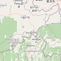
Geography guide, regional context, and park location map for Doi Pha Hom Pok National Park

Doi Pha Hom Pok National Park park geography, regions, and map view in Thailand
Understand where Doi Pha Hom Pok National Park sits in Thailand through a broader geographic reading of the surrounding landscape, nearby location context, and its mapped position within the national park landscape.

How Doi Pha Hom Pok National Park fits into Thailand

Thailand is a Southeast Asian nation formerly called Siam, located in mainland Southeast Asia. It operates as a unitary parliamentary constitutional monarchy under King Vajiralongkorn. The country borders Myanmar, Laos, Cambodia, and Malaysia, with maritime boundaries involving Vietnam, Indonesia, and India. Thailand has a population of nearly 66 million and covers approximately 513,120 km². Historically, the Sukhothai Kingdom marks the beginning of Thai history, followed by the powerful Ayutthaya Kingdom.

Wider geography shaping Doi Pha Hom Pok National Park in Thailand

Thailand occupies mainland Southeast Asia with borders to Myanmar (west/northwest), Laos (east/northeast), Cambodia (southeast), and Malaysia (south). The country has coastline along the Gulf of Thailand to the southeast and the Andaman Sea to the southwest. The territory covers approximately 513,120 km².

Map view of Doi Pha Hom Pok National Park

Use this park location map to pinpoint Doi Pha Hom Pok National Park in Thailand, understand its exact geographic position, and read its mapped placement within the surrounding landscape more clearly.

Pigeon | © OpenStreetMap contributors

Location context for Doi Pha Hom Pok National Park

Chiang Mai Province
Park atlas

Map the rugged Daen Lao Range landscapes and compare diverse mountain ecosystems across regional park geography.

Explore Other National Parks and Protected Areas Near Doi Pha Hom Pok National Park, Northern Thailand
Users exploring Doi Pha Hom Pok National Park can delve deeper into the unique protected areas that define Northern Thailand's mountainous terrain. Compare high-altitude cloud forests, geothermal features, and exceptional biodiversity across a broader atlas of connected landscapes and park geography.
National parkChiang Mai Province

Doi Wiang Pha National Park: Protected Mountainous Terrain and Watershed Dynamics in Northern Thailand

Explore the geography of this vital national park's peaks and valleys.

Doi Wiang Pha National Park stands as a significant national park in Chiang Mai Province, renowned for its dramatic mountainous terrain and its crucial function as a watershed. The park's complex system of ridges and valleys, along with its central peak, Doi Wiang Pha, defines its rugged landscape. Its waters feed into the Fang and Mae Lao river systems, highlighting its ecological importance for regional agriculture and communities. Understanding Doi Wiang Pha National Park through its mapped geography reveals a key protected area within northern Thailand's atlas of natural landscapes.

Area
343.37 km²
IUCN
II
Visitors
939 annual
Relief
Mountain
National parkMae Hong Son Province

Huai Nam Dang National Park: Northern Thailand's Mountainous Protected Landscape

Explore mapped terrain and protected area boundaries in Mae Hong Son Province.

Huai Nam Dang National Park offers a detailed look into Thailand's mountainous north, featuring rugged terrain characterized by steep slopes and deep valleys. This protected area, a key national park within Mae Hong Son Province, provides a valuable case study for understanding regional geography and landscape context. Its elevation ranges from low-lying valleys to the Doi Chang summit, contributing to its significance as a watershed and natural wilderness.

Area
1,252 km²
Established
1995
IUCN
II
Visitors
121.1K annual
National parkChiang Mai Province

Pha Daeng National Park: National Park in Chiang Mai Province's Mountainous Geography

Mapped protected area in the Thai highlands.

Pha Daeng National Park represents a significant protected natural area within the expansive geography of Chiang Mai Province. This national park provides a clear example of mapped conservation landscapes in Northern Thailand, contributing to the region's broader geographic identity. Users can explore the park's defined boundaries and understand its role within the mountainous terrain, offering essential context for atlas-based landscape discovery.

Area
1,123 km²
Established
2000
IUCN
II
Visitors
39.5K annual
Watercolor landscape featuring mountains, a lake, and trees in the foreground
National parkChiang Rai Province

Lam Nam Kok National Park: Protected Landscape Geography in Chiang Rai Province

Explore the mapped boundaries and regional context of this national park.

Lam Nam Kok National Park stands as a notable protected area within the diverse geography of Chiang Rai Province. This page provides detailed insight into its specific geographic identity, helping users understand its mapped boundaries and its significance as part of Thailand's protected natural landscapes. Discover the park's place within the regional context of the Thai highlands, facilitating a more profound atlas-driven understanding of conservation areas in northern Thailand.

Area
634.87 km²
Established
2002
IUCN
II
Visitors
197.1K annual
National parkChiang Mai Province

Si Lanna National Park: A Protected Landscape within Chiang Mai Province

Discover its geographic context and mapped protected area identity.

Si Lanna National Park is a designated national park located in the northern Thai highlands of Chiang Mai Province. This entry provides essential geographic context, detailing the park's mapped boundaries and its place within the regional atlas. Users can explore the protected landscape's characteristics and understand its role in the diverse geography of northern Thailand, serving as a key point for atlas-driven discovery of natural areas.

Area
1,405 km²
Established
1989
IUCN
II
Visitors
89.4K annual
Illustration showing steep mountain cliffs, a valley filled with clouds, and a waterfall, with pine trees in the foreground and a sun in the sky.
National parkChiang Rai Province

Khun Chae National Park: Protected Landscape and Geographic Detail in Chiang Rai Province

Explore mapped boundaries and natural terrain within Northern Thailand.

Khun Chae National Park is a designated national park offering a focused view of protected landscape geography within Chiang Rai Province. This entry provides structured details on its mapped boundaries and regional geographic context, serving as a key point for atlas-style discovery of Thailand's natural areas. Understand the park's identity as a protected landmass and its contribution to the natural geography of the Thai highlands.

Area
270 km²
Established
1995
IUCN
II
Visitors
11.2K annual
National parkThailand

Doi Luang National Park: Northern Thailand's Extensive Mountain Protected Area

Mapped terrain, forest ecosystems, and watershed significance.

Doi Luang National Park is a substantial protected landscape situated in the Phi Pan Nam Range of Northern Thailand, covering extensive mountainous territory. The park's geographic importance is highlighted by its role in protecting critical headwater ecosystems for both the Wang and Lao Rivers, featuring rugged ridgelines and significant natural terrain. Discover the mapped boundaries and conservation value of this expansive national park, integral to Thailand's regional geography and ecological health.

Area
1,169 km²
Established
1990
IUCN
II
Visitors
41K annual
National parkMae Hong Son Province

Tham Pla, Namtok Pha Suea National Park: Detailed National Park Geography and Map Context

Explore protected landscapes in Mae Hong Son Province, Thailand.

Tham Pla, Namtok Pha Suea National Park is a designated national park offering critical insights into the protected areas and natural terrain of Mae Hong Son Province. This page serves as a comprehensive resource for understanding the park's geographic footprint, its position within the mountainous region of northern Thailand, and its role as a protected landscape. Users can explore its mapped boundaries and regional geographic context for atlas-driven discovery.

Area
630 km²
Established
2010
IUCN
II
Visitors
89K annual

Common questions about visiting, size, designation, and location context for Doi Pha Hom Pok National Park

Doi Pha Hom Pok National Park FAQs for park facts, access, geography, and protected area context
Find quick answers about Doi Pha Hom Pok National Park, including protected-area facts, park geography, trail and visitor context, and how the park fits into its surrounding country and regional landscape.
MoriAtlas Explorer

Continue Your Protected Areas Search Across the Global Atlas

Deepen your exploration by continuing the structured search for national parks and protected areas worldwide. Utilize the comprehensive filtering capabilities to compare different conservation landscapes and refine your understanding of global park geography. Discover more about the distribution and characteristics of protected natural areas.

Global natural geography