Mori Atlas logo
Nature reserveDörneberg bei Viesebeck

Discover the mapped boundaries and unique ecological mosaic of this lime-rich protected terrain.

Dörneberg bei Viesebeck: A Protected Calcareous Landscape and Nature Reserve in Hessen, Germany

(Naturschutzgebiet Dörneberg bei Viesebeck)

Dörneberg bei Viesebeck represents a vital protected landscape within the Hessen region, known for its rare calcareous dry grasslands and orchid-rich beech forests. This nature reserve, integrated into the European Natura 2000 network, preserves a distinctive mosaic of thin soils and rocky outcrops formed over limestone bedrock. The site provides essential habitat for threatened plant communities and the strictly protected sand lizard, maintaining a critical refuge for lime-dependent ecosystems in central Germany.

calcareous grasslandKalkmagerrasenorchid-rich habitatcalcareous beech forestNatura 2000 siteFFH-Gebiet

Dörneberg bei Viesebeck

Nature reserve

Park overview

Structured park overview, official facts, and landscape profile for Dörneberg bei Viesebeck

Dörneberg bei Viesebeck park facts, protected area profile, and essential visitor context

Review the core facts for Dörneberg bei Viesebeck, including designation, size, terrain, visitor scale, habitats, and operating context in one park-focused overview.

About Dörneberg bei Viesebeck

Dörneberg bei Viesebeck is a compact but ecologically distinctive nature reserve in the rolling countryside of northern Hesse, in the Landkreis Kassel region. Although it spans only around 25 hectares, its geological foundation of limestone gives it an ecological character quite unlike the typically acidic, forested landscapes that dominate much of central Germany. This calcareous substrate has produced a remarkable mosaic of habitats, including open dry grasslands, pioneer calcareous swards on thin soils, orchid-rich beech forest, and traditionally managed hay meadows, all compressed into a small, easily walkable area just south of the village of Viesebeck.

The reserve's identity is closely tied to its long human history. The hill has likely been used since the Stone Age, and for centuries it served as grazing land for sheep and goats; one part of the landscape still carries the historical field name Ziegenköppel in reference to this pastoral past. Mid-19th century maps from the Kurhessischer Generalstab even show the Dörneberg as largely open and treeless, a reminder that many of today's seemingly wild calcareous grasslands are in fact cultural landscapes shaped by extensive grazing. Limestone was also quarried here historically for building stone and the production of quicklime, leaving behind a legacy of small-scale quarrying scars that now contribute to the habitat's structural diversity.

Ecologically, the site is significant both regionally and at the European level. Domestically, it has been protected as a Naturschutzgebiet since 1982, and it is managed jointly with the adjacent Wünne bei Viesebeck under the oversight of the Upper Nature Conservation Authority at the Regierungspräsidium Kassel, the Wolfhagen Forestry Office, and the agricultural department of the Landkreis Kassel. In 2003, both areas were additionally declared as a single FFH (Fauna-Flora-Habitat) site, recognising the European conservation importance of their calcareous grassland habitats. The reserve is a documented refuge for the strictly protected sand lizard and supports a varied bird community, but its most distinctive feature is its population of rare wild orchids, which thrive precisely because the thin, lime-rich soils have remained open and relatively undisturbed by intensive agriculture.

Quick facts and research context for Dörneberg bei Viesebeck

Dörneberg bei Viesebeck is a designated Naturschutzgebiet in Hesse, Germany, established on 21 December 1982 and covering about 25.57 hectares south of Wolfhagen-Viesebeck. It is paired with the neighbouring Wünne bei Viesebeck, and in 2003 the two were jointly designated as the FFH-Gebiet Dörneberg und Wünne bei Viesebeck (DE 4620-303). The reserve's core ecological value lies in its calcareous dry grasslands, orchid-rich beech forest, pioneer calcareous swards, and low-intensity hay meadows on limestone bedrock.

Protection and recognition

Examine the documented conservation framework and international recognition data

Dörneberg bei Viesebeck Protection Status and Official Designation Records

Dörneberg bei Viesebeck maintains recorded protected area designation records alongside verified conservation datasets. Official administrative entries compile available management scope and international recognition metrics for the natural landscape.

Protection details

WDPA ID
81539
Park context

Deeper park guide and search-rich context for Dörneberg bei Viesebeck

Dörneberg bei Viesebeck history, landscape, wildlife, and travel context

Explore Dörneberg bei Viesebeck through its history, landscape character, ecosystems, wildlife, conservation priorities, cultural context, and seasonal travel timing in a structured park guide built for atlas discovery and search intent.

Why Dörneberg bei Viesebeck stands out

Dörneberg bei Viesebeck is best known for its concentration of calcareous dry grassland (Kalkmagerrasen) and orchid-rich calcareous beech forest on limestone soils. The reserve is particularly valued for rare wild orchid species such as the bee orchid (Bienen-Ragwurz), the purple orchid (Purpur-Knabenkraut), and the green woodland orchid (Grünliche Waldhyazinthe), and for being one of only a few protected sites in the Landkreis Kassel where these lime-dependent habitat types persist in close proximity.
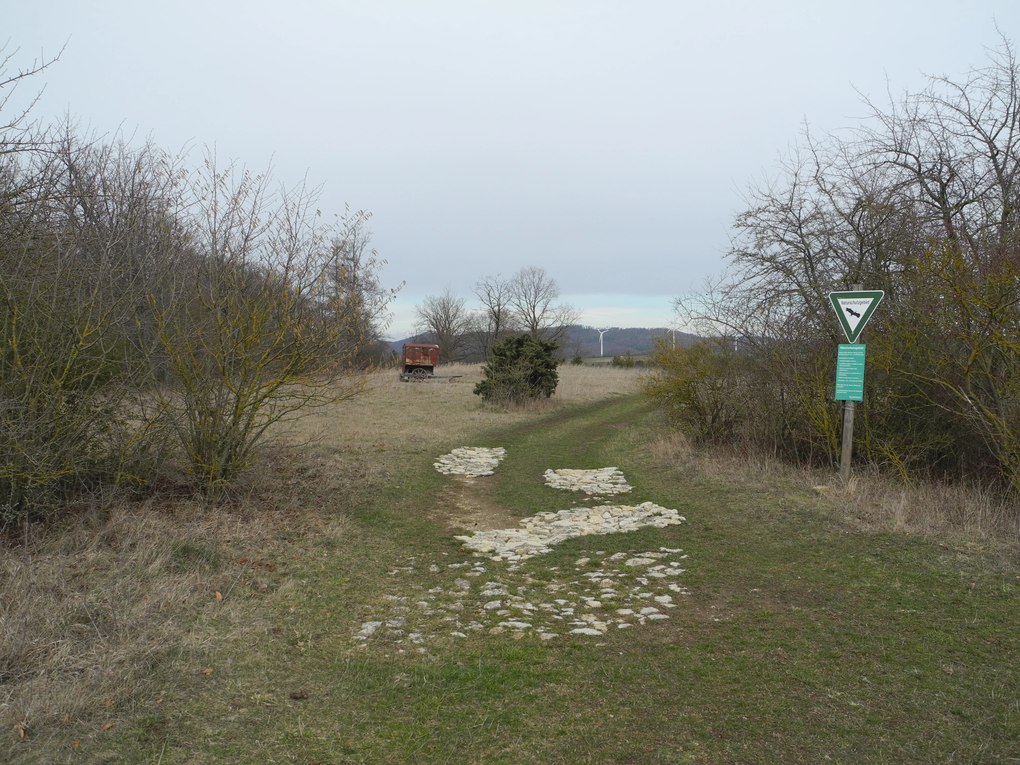
A dirt path with light-colored stones embedded in the ground leads into a grassy field bordered by shrubs and trees in a nature reserve on an overcast day, with a triangular nature reserve sign visible on the right.
A path leading into the landscape of the Dörneberg bei Viesebeck nature reserve.

Dörneberg bei Viesebeck history and protected-area timeline

The area around the Dörneberg has a long history of human use, with archaeological evidence suggesting settlement or repeated use dating back to the Stone Age. For centuries, the hill served as open pasture for sheep and goats, and this grazing regime is the reason certain parts of the area still carry names like Ziegenköppel. In 1859, a map sheet produced by the Kurhessischer Generalstab depicted the Dörneberg as being essentially treeless, indicating that the open grassland character of the summit was maintained by continuous pastoral use rather than being an untouched natural feature.

In addition to grazing, the hill was also used for small-scale limestone quarrying. Like the nearby Wünne, the Dörneberg was quarried for building stone and for the production of quicklime (Branntkalk), an activity that left lasting surface features across the landscape. After centuries of agricultural and extractive use, however, recognition of the site's natural value grew, and on 21 December 1982 the area was formally designated as a Naturschutzgebiet by the state of Hesse, securing protection for roughly 25.57 hectares of calcareous grassland, woodland, and meadow.

Even after designation, agricultural practices persisted on parts of the hill; it remained possible to use pesticides and fertilisers on portions of the Dörneberg until 1992. Today, low-intensity grazing continues on parts of the reserve as a management tool to maintain the open grassland habitats. A further milestone came in 2003, when Dörneberg bei Viesebeck and the neighbouring Wünne bei Viesebeck were together declared as a single Natura 2000 FFH site (DE 4620-303), extending their protection under European Union nature conservation law.

Dörneberg bei Viesebeck landscape and geographic character

The Dörneberg is a small, gently rising hill in the countryside south of Wolfhagen-Viesebeck, set within the broader undulating landscape of northern Hesse. Its defining physical characteristic lies beneath the surface: the bedrock is limestone, and across much of the hill the overlying soils are thin, dry, and calcareous. Where grazing has kept the vegetation open, this produces exposed rocky outcrops, shallow soils, and warm microclimates that are rare in a region otherwise dominated by more acidic, forested terrain.

The resulting landscape is a patchwork rather than a uniform habitat. Open, sun-exposed calcareous dry grasslands occupy the upper and steeper slopes, interspersed with pioneer swards forming on the thinnest soils. Where the slope allows slightly deeper soil, calcareous beech woodland (Kalkbuchenwald) takes over, producing a striking contrast between bright open grassland and shaded forest stands within a very short distance. Small structural features left by historical limestone quarrying add further variety, creating rock faces, ledges, and sheltered pockets that increase the topographic complexity of what is, area-wise, a very small site.

Because of its modest size and the visual contrast between open grassland and beechwood, the Dörneberg feels like a compressed landscape mosaic where characteristic features of much larger calcareous regions are condensed into a few dozen hectares.

Dörneberg bei Viesebeck ecosystems, habitats, and plant life

The nature of Dörneberg bei Viesebeck is defined by its calcareous, lime-rich soils and the open-or-half-open habitats they support. The defining habitat type is Kalkmagerrasen, calcareous dry grassland, which is among the most species-rich and most threatened habitat types in Central Europe. Where soils are thinnest and most disturbed, pioneer calcareous swards develop, while slightly more developed sites support traditionally managed hay meadows classified as mageren Flachland-Mähwiesen (low-intensity species-rich meadows). Together these open habitats form the ecological backbone of the reserve.

Interspersed with the grassland is a characteristic orchid-rich calcareous beech forest, a woodland type that depends on exactly the same limestone substrate and is closely linked to the open habitats ecologically. The proximity of open grassland and calcareous woodland within a few hectares is unusual and gives the site a layered vegetation structure: a mosaic of grassland, woodland edge, and closed forest, each supporting different plant and animal communities.

The calcareous substrate also produces a distinctive spring flora and a high concentration of orchids and other lime-loving plants. Because many of Germany's more common habitats have been either afforested, fertilised, or built over, the continued existence of a small but well-managed calcareous complex like the Dörneberg has become ecologically more important than its modest size would suggest.

Dörneberg bei Viesebeck wildlife and species highlights

Although best known for its plant communities, Dörneberg bei Viesebeck also supports a notable range of animal life for a site of its size. The reserve has been documented as a habitat for a variety of bird species, which use the mix of open grassland, scrub edge, and beechwood for breeding and foraging within a compact area.

A particularly important faunal feature is the presence of the sand lizard (Zauneidechse), a strictly protected reptile species in Germany. Warm, sun-exposed rocky areas and dry grassland provide ideal habitat for the species, and the small-scale quarrying features on the Dörneberg add the kind of stony, sheltered microhabitats the lizard favours. The combination of dry open ground and nearby woodland edges is characteristic of high-quality sand lizard sites.

More broadly, the reserve's mosaic of calcareous grassland, meadow, and forest supports a typical community of invertebrates associated with flower-rich dry grasslands, including pollinators that depend on the site's wild orchids and other lime-loving flowering plants. While the site's modest size limits populations of larger mammals, the structural diversity of the reserve provides habitat for small mammals, reptiles, and a rich insect fauna typical of well-preserved calcareous landscapes.

Dörneberg bei Viesebeck conservation status and protection priorities

The conservation significance of Dörneberg bei Viesebeck lies primarily in the protection of calcareous dry grasslands and their associated flora and fauna, habitat types that have declined sharply across Central Europe due to agricultural intensification, afforestation, and abandonment of traditional grazing. As a designated Naturschutzgebiet since 1982, the site has legal protection under Hessian nature conservation law, with management oversight shared between the Upper Nature Conservation Authority at the Regierungspräsidium Kassel, the Wolfhagen Forestry Office, and the agricultural department of the Landkreis Kassel.

The recognition of Dörneberg and Wünne bei Viesebeck as a joint FFH-Gebiet (DE 4620-303) in 2003 raised the conservation profile of the area to the European level. As a Natura 2000 site, the reserve contributes to the conservation of habitat types listed under the EU Habitats Directive, including calcareous dry grasslands, calcareous beech woodland, pioneer calcareous swards, and low-intensity hay meadows, as well as a range of threatened orchid species.

Conservation management relies on a continuation of the land-use practices that historically shaped the site. Low-intensity grazing is still practised on parts of the Dörneberg, helping to prevent scrub encroachment and to maintain the open calcareous grassland on which many of the site's species depend. The prohibition of pesticides and fertilisers across the reserve since 1992 has been a key step in halting the nutrient enrichment that would otherwise have degraded the species-rich flora. The continued interplay of grazing, restricted input use, and protected status is what allows the reserve to maintain its orchid-rich, lime-dependent character.

Dörneberg bei Viesebeck cultural meaning and human context

The Dörneberg is as much a cultural landscape as a natural one. Centuries of grazing by sheep and goats have shaped its open character and are still reflected in local field names such as Ziegenköppel. The historic presence of the Kurhessischer Generalstab's mapping activities in the mid-19th century also preserves an unusually clear documentary record of how the hill looked at a moment when it was largely treeless grazing land rather than the partly wooded mosaic seen today.

Small-scale limestone quarrying for building stone and quicklime production added a further human dimension to the hill, leaving behind the very rock features and open surfaces that today support rare orchids and sand lizards. This layered history of pastoral use, quarrying, and eventual formal protection makes the Dörneberg a useful example of how a working agricultural landscape can evolve into a scientifically and ecologically valued protected area while retaining traces of its earlier use.

Top sights and standout views in Dörneberg bei Viesebeck

Key standout qualities of Dörneberg bei Viesebeck include its concentration of rare wild orchids on limestone soil, the close juxtaposition of calcareous grassland and calcareous beech woodland within a very small area, and its protected status under both Hessian and European Union nature conservation law. The reserve is distinguished by the persistence of traditional grazing as a management tool, the presence of the strictly protected sand lizard, and its role within the larger Natura 2000 network of calcareous habitats in northern Hesse.

Best time to visit Dörneberg bei Viesebeck

Spring and early summer are typically the most rewarding periods to experience calcareous grassland reserves like Dörneberg bei Viesebeck, as this is when wild orchids and other lime-loving flowering plants are at their peak and the open grasslands are at their most visually striking. Late spring can also offer active reptile sightings in warm, sun-exposed rocky areas. Autumn can be pleasant for observing the beech forest component and any remaining grazed grassland character, while winter visits highlight the contrast between open rocky slopes and surrounding woodland. Visitors should generally expect a quiet, largely unmanaged natural setting without extensive visitor infrastructure.

Monthly climate preview

Long-term monthly temperature ranges and precipitation patterns measured at representative coordinates

Dörneberg bei Viesebeck Climate Normals, Annual Temperature and Precipitation Rhythm

Representative coordinates record long-term monthly temperature and precipitation rhythms across the protected landscape, tracking average extremes and daily means from NASA climatology data. Examining the complete twelve-month profile reveals detailed baseline variations in annual weather patterns for this regional terrain.
Annual mean8 °C
-1 °C18 °C
Jan-1°
Feb
Mar
Apr
May12°
Jun16°
Jul18°
Aug18°
Sep14°
Oct
Nov
Dec
Warmest month
July

18 °C

Coolest month
January

-0.6 °C

Wettest month
July

2.5 mm/day

Driest month
April

1.5 mm/day

Park location guide

Geography guide, regional context, and park location map for Dörneberg bei Viesebeck

Dörneberg bei Viesebeck park geography, regions, and map view in Germany

Understand where Dörneberg bei Viesebeck sits in Germany through a broader geographic reading of the surrounding landscape, nearby location context, and its mapped position within the national park landscape.

How Dörneberg bei Viesebeck fits into Germany

Germany is a federal republic in Western and Central Europe with a population of over 83 million across sixteen constituent states. It is Europe's largest economy by nominal GDP and a major global exporter and importer. The capital is Berlin, and the country borders Denmark, Poland, Czech Republic, Austria, Switzerland, France, Luxembourg, Belgium, and the Netherlands.

Wider geography shaping Dörneberg bei Viesebeck in Germany

Germany is located in Western and Central Europe, spanning 357,022 km². It borders Denmark to the north, Poland and the Czech Republic to the east, Austria and Switzerland to the south, and France, Luxembourg, Belgium, and the Netherlands to the west. The country has coastlines on the Baltic Sea and North Sea to the north, with the Alps located in the southern region.

Map view of Dörneberg bei Viesebeck

Use this park location map to pinpoint Dörneberg bei Viesebeck in Germany, understand its exact geographic position, and read its mapped placement within the surrounding landscape more clearly.

Pigeon | © OpenStreetMap contributors

Location context for Dörneberg bei Viesebeck

Hessen

Visualizing calcareous grasslands, beech woods, and protected limestone terrain

Dörneberg bei Viesebeck Photos and Landscape Scenery Exploration

Examine detailed photographs showcasing the limestone topography, sun-exposed dry grasslands, and shaded beech woodland defining Dörneberg bei Viesebeck. Visual reference imagery helps interpret the rare plant habitats and compressed mosaic structure preserved across the protected reserve.

A dirt path with light-colored stones embedded in the ground leads into a grassy field bordered by shrubs and trees in a nature reserve on an overcast day, with a triangular nature reserve sign visible on the right.

Park atlas

Compare regional limestone habitats and connected nature reserves in northern Hesse

Parks Near Dörneberg bei Viesebeck and Related Protected Landscapes

Browse nearby national parks and protected areas sharing similar limestone soils, dry grasslands, and forest mosaics. Comparing adjacent reserves helps trace the broader ecological spread of rare habitats across the surrounding region.
A soft watercolor painting depicting rolling green hills against a faint, light-colored background.
Nature reserveHessen
About 4.9 km away#1 closest

East

Festberg bei Philippinenthal Nature Reserve: Geography and Protected Landscape Context

A rare calcareous grassland ecosystem in northern Hessen.

Festberg bei Philippinenthal encompasses a ridge of tilted Muschelkalk limestone rising above the Lohbach stream in Hessen. This nature reserve protects a vital combination of juniper heath, dry calcareous grassland, and small-scale forest habitats maintained by historic and modern conservation grazing, offering a clear example of local geology shaping biodiversity.

Area
0.143 km²
Established
1992
IUCN
IV
A horizontal watercolor painting depicting a calm wetland landscape with soft green trees, grassy banks, and rolling hills in the background.
Nature reserveHesse
About 5.5 km away#2 closest

Southeast

Glockenborn bei Bründersen Nature Reserve: Regional Geography and Wetland Protected Areas

A mapped overview of wetland terrain in northern Hesse

Glockenborn bei Bründersen offers a focused look at how managed wetlands integrate into the agricultural landscape of northern Hesse. Known for its distinct shallow lakes and bird-rich environments, this nature reserve serves as an essential case study in ecological restoration and the maintenance of open grazing lands within a protected boundary.

Area
0.07 km²
Established
2004
A pale watercolor painting showing a rolling landscape with soft green hills, scattered trees, and a hazy mountain silhouette against a white background.
Nature reserveHesse
About 12 km away#3 closest

South

Auf den Hesseln bei Naumburg Nature Reserve: Protected Landscape and Geography Atlas

A calcareous grassland mosaic within the Kassel district of Hesse

This protected area in northern Hesse encompasses a complex relief of Triassic mussel limestone slopes and alluvial woodland. The site highlights the importance of managed limestone dry grasslands and former quarry habitats in supporting specialized flora, serving as a concentrated example of habitat diversity within the surrounding agricultural landscape.

Area
0.196 km²
Established
1996
Relief
Upland
Climate
Temperate
A horizontal watercolor painting depicting a soft, rolling landscape with green hills, conifer trees, and misty purple mountains in the background against a white backdrop.
Nature reserveLandkreis Kassel
About 13 km away#4 closest

East

Dörnberg Nature Reserve: Geographic Map and Protected Landscape Overview in Landkreis Kassel

Analyzing the limestone slopes and volcanic terrain of the Dörnberg massif.

Explore the Dörnberg nature reserve through a geographic lens, focusing on its protected status within the Landkreis Kassel region. This area encompasses 116 hectares of steep limestone slopes, supporting a dense collection of calcareous grasslands and rare orchid species. The site is physically defined by its striking Miocene basalt outcrop, providing a clear focal point for studying regional Hessian topography and conservation-led land management.

Area
1.166 km²
Established
1978
Relief
Mountain
Climate
Temperate
Watercolor painting of a rolling forested landscape with distant hills under a soft light.
Nature reserveHesse
About 13 km away#5 closest

East

Erlebach bei Ehlen Nature Reserve: Protected Terrain and Brook Valley Geography in Hesse

Mapped beech forest mosaic and riparian habitat corridors

Located in the Hoher Habichtswald, Erlebach bei Ehlen preserves a distinctive transition between mature beech forest and open grassland valley. This nature reserve serves as an essential case study for understanding riparian ecology, stream-side woodland distribution, and habitat connectivity within the regional topography of Hesse, Germany.

Area
0.342 km²
Established
1996
Watercolor painting of a soft, rolling landscape with green fields, distant hills, and low foreground vegetation.
Protected areaGermany
About 14 km away#6 closest

Southeast

Langenberger Huete bei Breitenbach: Mapped Geography and Protected Area Landscape Context

Nature reserve terrain and grassland boundaries in northern Hesse

Examine the geographic layout of Langenberger Huete bei Breitenbach, a protected dry grassland area near Schauenburg, Germany. This site preserves open meadow habitats along the forested Langenberg ridge, offering insight into traditional land use and small-scale conservation within the Habichtswald region. Access detailed boundary data and terrain information to understand its position within the surrounding agricultural and woodland zones.

Area
0.14 km²
Established
1992
Relief
Upland
Climate
Temperate
Watercolor painting showing a landscape with hills, forest, and a body of water
National parkHesse
About 16 km away#7 closest

Southwest

Kellerwald-Edersee National Park: Hesse's Protected Landscape Exploration

Mapped boundaries and geographic context for this German national park.

Navigate the protected landscape of Kellerwald-Edersee National Park, a key national park situated in the German state of Hesse. This atlas entry focuses on its precise geographic definition, mapped terrain features, and the broader regional context it occupies within central Germany. Gain structured insights into the park's conservation significance and its place in the mapped landscape.

Area
76.88 km²
Established
2004
IUCN
II
Relief
Highland
A horizontal watercolor painting showing a soft, hazy landscape with green hills, patches of grass, and purple-tinted distant mountains under a white sky.
Nature reserveLandkreis Kassel
About 17 km away#8 closest

East

Keischel bei Weimar: Nature Reserve Protected Area and Regional Geography

A calcareous grassland mosaic in the Landkreis Kassel district

Keischel bei Weimar preserves a 19.7-hectare landscape defined by Muschelkalk limestone bedrock and traditional agricultural practices. This nature reserve serves as a critical refuge for specialized flora and insect species, showcasing the value of integrated land management within the broader West Hessian Depression and northern Hesse regional geography.

Area
0.197 km²
Established
1992
Relief
Upland
Climate
Temperate

Common questions about visiting, size, designation, and location context for Dörneberg bei Viesebeck

Dörneberg bei Viesebeck FAQs for park facts, access, geography, and protected area context

Find quick answers about Dörneberg bei Viesebeck, including protected-area facts, park geography, trail and visitor context, and how the park fits into its surrounding country and regional landscape.
MoriAtlas Explorer

Continue Your Protected Areas Search Across the Global Atlas

Deepen your exploration by continuing the structured search for national parks and protected areas worldwide. Utilize the comprehensive filtering capabilities to compare different conservation landscapes and refine your understanding of global park geography. Discover more about the distribution and characteristics of protected natural areas.

Global natural geography