

Mori Atlas logo
National parkDorob National Park

Explore the unique geography and mapped boundaries of this Important Bird Area.

Dorob National Park: Namibia's Vast Coastal Protected Landscape and Bird Atlas

Dorob National Park represents a significant protected landscape along the central Namibian coast, encompassing over 1,600 kilometers of hyper-arid desert meeting the Atlantic Ocean. This national park is recognized as Namibia's richest coastal region for birdlife, supporting a vast number of species and playing a crucial role in regional biodiversity. Discover the park's dramatic dune belts, gravel plains, ephemeral river systems, and vital wetland areas through its detailed geography and mapped context.

Coastal DesertBird ConservationImportant Bird AreaNamib DesertMarine-Coastal InterfaceEndemic Species

Dorob National Park

National park

Park overview

Structured park overview, official facts, and landscape profile for Dorob National Park

Dorob National Park park facts, protected area profile, and essential visitor context

Review the core facts for Dorob National Park, including designation, size, terrain, visitor scale, habitats, and operating context in one park-focused overview.

About Dorob National Park

Dorob National Park represents Namibia's commitment to protecting its unique coastal desert ecosystems along the central Atlantic coast. The park extends from the Kuiseb Delta, located south of the port town of Walvis Bay, northward to the Ugab River, while extending westward from the Atlantic Ocean to the boundaries of the former National West Coast Tourist Recreation Area. This 1,600-kilometer stretch of coastline represents a critical habitat corridor connecting various protected zones into an almost continuous barrier of parks from the Kunene River on the Angolan border to the Orange River on the South African border. The park's establishment in December 2010 fulfilled a long-term vision of creating one continuous coastal protected area, though it excludes certain developed areas including the towns of Swakopmund, Henties Bay, and Wlotzkasbaken, as well as infrastructure such as railway lines and major road reserves. The park is governed by Namibia's Ministry of Environment and Tourism and is managed as an open system with connections to marine, coastal, and escarpment environments, with particular emphasis on preventing and minimizing damage to important habitats while promoting long-term ecosystem health and climate change adaptation.

Quick facts and research context for Dorob National Park

Dorob National Park occupies a unique position along Namibia's central Atlantic coast, spanning the transition between the Namib Desert and the ocean. The park was officially declared under Namibia's Nature Conservation Ordinance No.4 of 1975, becoming the nation's second-largest national park after Namib-Naukluft. It encompasses diverse coastal habitats including the Kuiseb Delta, Tsumas Delta, Walvis Bay Lagoon, extensive dune systems, and gravel plains. The park is managed as an interconnected system linking marine, coastal, and escarpment ecosystems, with specific zones designated for conservation including Damara tern breeding sites, important bird areas, and delicate lichen fields.

Protection and recognition

Analyzing the documented establishment framework and mixed conservation scope of the coastal reserve

Dorob National Park Protection Status and Official Designation History

Dorob National Park features a mixed protection scope established in 2010 to safeguard sensitive Namibian coastal desert geography. Documented conservation frameworks and official designation parameters offer essential context for comparing regional land-management systems across southern Africa.

Protection details

Protection scope
Mixed
Designated year
2010
Transboundary protection
No
Park context

Deeper park guide and search-rich context for Dorob National Park

Dorob National Park history, landscape, wildlife, and travel context

Explore Dorob National Park through its history, landscape character, ecosystems, wildlife, conservation priorities, cultural context, and seasonal travel timing in a structured park guide built for atlas discovery and search intent.

Why Dorob National Park stands out

Dorob National Park is best known for its remarkable coastal bird populations, particularly the Damara tern, a seabird species endemic to Namibia that serves as the park's flagship species. The park protects a spectacular coastal dune belt, vast gravel plains, Namibia's richest coastal bird habitat, and major ephemeral river systems that flow into the Atlantic. The dramatic landscape where the hyper-arid Namib Desert meets the cool Atlantic Ocean creates a starkly beautiful environment that supports unexpected biodiversity in one of the world's driest regions.

Dorob National Park history and protected-area timeline

Before achieving national park status, the area that now comprises Dorob National Park was known as the Walvis Bay Nature Reserve under the administration of South Africa's Cape Department of Nature Conservation. Following Namibia's independence in 1990, the Walvis Bay enclave was incorporated into Namibian territory, and the reserve came under national administration. Various proposals to rename the protected area Walvis Bay National Park did not come to fruition, ultimately leading to the decision to name the central coastal area Dorob National Park, derived from the local word meaning "dry land." The park was officially gazetted under the Nature Conservation Ordinance No.4 of 1975 on December 1, 2010. The establishment of Dorob completed a significant conservation corridor along Namibia's coast, with National Geographic noting in June 2011 that the creation of the park had resulted in an almost continuous chain of protected areas from the Kunene River to the Orange River. The Trans-Kalahari Highway passes through the park, connecting several mining, fishing, and industrial towns in the region. In 2012, the park gained international attention when parts of Mad Max: Fury Road were filmed there, with allegations that filming caused significant damage to the park's habitat.

Dorob National Park landscape and geographic character

The landscape of Dorob National Park is defined by the dramatic encounter between the hyper-arid Namib Desert and the cold waters of the Atlantic Ocean. The park encompasses a spectacular coastal dune belt that runs parallel to the shore, creating a striking visual boundary between desert and sea. Vast gravel plains extend inland from the dunes, interrupted by the dry beds of major ephemeral river systems including the Kuiseb River, Swakop River, and their respective deltas. The Kuiseb Delta, located south of Walvis Bay, and the Tsumas Delta represent critical wetland habitats within this generally arid environment. The Walvis Bay Lagoon, a designated Ramsar Site of international importance, marks a key coastal wetland area within the park's boundaries. The landscape transitions from the coastal zone westward across the dune and gravel plain systems toward the interior escarpment, creating a gradient from marine-influenced environments to true desert conditions.

Dorob National Park ecosystems, habitats, and plant life

The nature of Dorob National Park is characterized by remarkable ecological adaptations to extreme aridity along the coast, combined with exceptional biodiversity in specific habitat pockets. The central coast's 1,600-kilometer stretch represents an area of hyper-arid desert where rainfall is extremely limited and fog from the Atlantic provides the primary moisture source for many organisms. The park contains Namibia's richest coastal area for birds, with approximately 75 bird species recorded and nearly 1.6 million individual birds counted along the coast. Major ephemeral river systems and their river mouths create important habitat corridors, while the dune and gravel plain environments support specialized desert-adapted species. Lichen fields represent a particularly notable component of the park's ecological character, with these slow-growing organisms forming delicate communities on gravel substrates. The park's ecological significance has been recognized through its designation as an Important Bird Area by BirdLife International, acknowledging its global importance for seabird conservation.

Dorob National Park wildlife and species highlights

Dorob National Park supports exceptional birdlife that represents the park's most notable wildlife significance. The coastline hosts nearly 1.6 million birds across approximately 75 species, making it Namibia's richest coastal bird area. The Damara tern, a small seabird endemic to Namibia, serves as the park's flagship species and breeds along the coast, though individuals migrate northward in winter. This tern species is recognized as a flagship for coastal conservation in the region. The park provides critical habitat for numerous seabird species that utilize the coastal waters, beaches, and dune systems for feeding and breeding. The Walvis Bay Lagoon and other wetland areas attract substantial waterbird populations, while the dune systems and gravel plains support specialized desert bird species adapted to the harsh coastal desert environment.

Dorob National Park conservation status and protection priorities

The conservation significance of Dorob National Park centers on its role in protecting a critical coastal corridor that links marine, terrestrial, and aquatic ecosystems along Namibia's central coast. The park's designation as an Important Bird Area by BirdLife International underscores its global significance for seabird conservation, particularly for the endemic Damara tern. Management of the park follows a zoned approach that identifies specific areas for protection including Damara tern breeding sites, important bird areas, the Kuiseb Delta, Sandwich Harbour, Swakop River, Tsumas Delta, Walvis Bay Lagoon, birding areas, and lichen fields. The park is managed as a connected system spanning marine, coastal, and escarpment environments, with explicit goals to prevent and minimize damage to important habitats while promoting long-term ecosystem health and climate change adaptation. Strict regulations govern activities within the park, prohibiting commercial, construction, and competitive activities without permits, and explicitly forbidding the feeding, containing, hunting, chasing, injuring, or killing of any animal.

Dorob National Park cultural meaning and human context

The cultural context of Dorob National Park reflects the historical development of Namibia's coastal regions and the evolution of conservation in the post-independence era. The park's name, Dorob, comes from the local word meaning "dry land," directly describing the hyper-arid desert environment that characterizes the region. Prior to national park designation, the area was administered as the Walvis Bay Nature Reserve under colonial-era structures, with the transition to Namibian control occurring following independence in 1990. The Walvis Bay enclave, including the former nature reserve, became incorporated into Namibia at this time. The park encompasses the traditional lands of indigenous communities who have inhabited this coastal desert region, with the ephemeral river systems historically providing critical water sources for both human populations and wildlife in an otherwise water-scarce environment.

Top sights and standout views in Dorob National Park

Dorob National Park stands out for protecting one of the world's most striking coastal desert environments where the Namib Desert meets the Atlantic Ocean. The park's 1,600-kilometer coastline represents a critical habitat corridor supporting exceptional bird biodiversity, with nearly 1.6 million birds of 75 species recorded, including the endemic Damara tern. The combination of spectacular coastal dunes, vast gravel plains, ephemeral river deltas, and the Walvis Bay Lagoon creates a mosaic of important habitats within a single protected area. The park's role in completing Namibia's coastal conservation corridor from Angola to South Africa represents a significant achievement in regional biodiversity protection. The dramatic landscape of desert dunes rising from the Atlantic coast provides one of Africa's most visually distinctive protected areas.

Best time to visit Dorob National Park

The optimal time to visit Dorob National Park depends on desired activities, with the cooler winter months from May to October generally offering more comfortable conditions for exploration. During this period, daytime temperatures are moderate and wildlife viewing, particularly birdwatching, is rewarding as migratory species are present along the coast. The dry season typically provides clearer visibility across the landscape, though fog from the Atlantic can create atmospheric conditions particularly in morning hours. Summer months bring higher temperatures but also the green season when ephemeral rivers may flow, creating temporary wetland conditions that attract additional birdlife. The Damara tern can be observed during breeding season, though specific timing varies. Visitors should note that certain zones within the park have access restrictions to protect sensitive habitats, particularly during breeding seasons.
Monthly climate preview

Analyze long-term temperature trends and minimal precipitation patterns in Namibia's coastal desert reserve

Dorob National Park Climate Profile and Historical Weather by Month

Long-term meteorological data from a representative coastal coordinate reveals moderate mean temperatures peaking around 19 degrees Celsius alongside extremely sparse year-round precipitation. Accessing the complete monthly climatology dataset provides deeper insight into the distinct diurnal temperature swings and seasonal shifts that shape the hyper-arid Namibian landscape.
Annual mean17 °C
15 °C20 °C
Jan19°
Feb20°
Mar19°
Apr19°
May18°
Jun17°
Jul17°
Aug15°
Sep15°
Oct16°
Nov17°
Dec18°
Warmest month
February

19.6 °C

Coolest month
August

15.4 °C

Wettest month
April

0.4 mm/day

Driest month
August

0 mm/day

Park location guide

Geography guide, regional context, and park location map for Dorob National Park

Dorob National Park park geography, regions, and map view in Namibia

Understand where Dorob National Park sits in Namibia through a broader geographic reading of the surrounding landscape, nearby location context, and its mapped position within the national park landscape.

How Dorob National Park fits into Namibia

Namibia is a sovereign country in Southern Africa that gained independence from South Africa in 1990. It is the driest country in sub-Saharan Africa, characterized by the Namib Desert along its coast. The population is approximately 3 million, with Windhoek as the capital and largest city. Namibia operates as a unitary semi-presidential republic with a multi-party system.

Wider geography shaping Dorob National Park in Namibia

Namibia occupies 825,615 km2 in Southern Africa, making it the 34th largest country in the world. It is bordered by the Atlantic Ocean to the west, Angola and Zambia to the north, Botswana to the east, and South Africa to the south. The country features the Namib Desert along its coastal region, with varied terrain including savannas, mountains, and plateaus inland. A notable geographic feature is that Zimbabwe lies less than 200 metres away along the Zambezi river near Kazungula in the northeast.

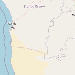
Map view of Dorob National Park

Use this park location map to pinpoint Dorob National Park in Namibia, understand its exact geographic position, and read its mapped placement within the surrounding landscape more clearly.

Pigeon | © OpenStreetMap contributors

Location context for Dorob National Park

Erongo
Natural feature types

View the Full Index of Natural Features and Landmarks in Dorob National Park

Use this structured atlas to browse named landforms, river deltas, and wetland systems associated with Dorob National Park. MoriAtlas provides detailed geographic context for the unique desert and marine interfaces found throughout this significant Namibian protected zone.
Park atlas

Compare Namibia's coastal protected areas, tracing the Atlantic interface with the Namib Desert

Discover Other National Parks and Protected Areas Near Dorob National Park

After exploring Dorob National Park, delve into additional protected areas within Namibia's unique coastal desert environment and the broader Namib Desert region. Trace the geographic spread of marine-influenced conservation landscapes and adjacent desert parks, comparing diverse ecosystems across a significant African protected zone.
National parkNamibia
Park boundaries overlap#1 closest

Southeast

Namib-Naukluft National Park: Namibia's Iconic Desert Landscape and Protected Terrain

Explore its ancient dunes, Naukluft mountains, and coastal geography.

Namib-Naukluft National Park is a colossal protected area in Namibia, holding the distinction of being Africa's largest national park. This park is renowned for its iconic sand dunes, particularly at Sossusvlei, which are among the highest in the world and display dramatic colors due to iron oxidation. The landscape also features the rugged Naukluft Mountains and vital coastal fog zones, creating a diverse arid environment. Delve into the mapped geography and unique terrain of this ancient desert setting, understanding its protected landscape significance within Namibia's atlas.

Area
49,768 km²
Established
1907
IUCN
II
Relief
Mixed relief
National parkNamibia
Park boundaries overlap#2 closest

Northwest

Skeleton Coast National Park: Namibia's Remote Desert-Coast National Park Exploration

Mapped landscape, shipwrecks, and profound geographic isolation.

Delve into the Skeleton Coast National Park, a monumental protected area in Namibia defined by its stark desert and ocean interface. This page provides detailed geographic context for the park's vast expanse, highlighting its characteristic shipwrecks and the dramatic landscape where towering sand dunes confront the cold Atlantic. Understand the unique protected-area identity of this legendary coastal wilderness through its mapped features and remote setting.

Area
16,845 km²
Established
1971
IUCN
II
Relief
Lowland
National parkKunene Region
183 km away#3 closest

North

Etosha National Park National Park: Mapped Protected Landscape and Regional Geography

Discover its protected boundaries and geographic context.

Gain a structured understanding of Etosha National Park, a prominent national park within Namibia's Kunene Region. This entry focuses on the park's protected landscape identity, detailing its mapped boundaries and geographic significance. Explore Etosha National Park through the lens of atlas-driven discovery, appreciating its role as a key protected area and its contribution to the regional geography of the surrounding landscape.

Area
22,270 km²
Established
1907
IUCN
II
Visitors
200K annual
Protected areaNamibia
About 192 km away#4 closest

East

Gross Barmen Protected Area: Landscape Geography and Thermal Spring Mapping in Namibia

Central Namibia thermal spring and historic natural monument

Gross Barmen is a state-managed recreation area in central Namibia, centered on a natural sulfurous spring that emerges within a flat thornveld landscape. This protected area acts as both a cultural heritage site and a geological feature, providing a clear window into the regional terrain of the Otjozondjupa area through its thermal waters and historical mission foundations.

Area
1 km²
Established
1968
Relief
Lowland
Climate
Arid
Protected landscapeOtjozondjupa
About 217 km away#5 closest

East

Von-Bach-Erholungsgebiet: A Protected Landscape of Dam Waters and Bushveld Terrain

Geographic overview of the Otjozondjupa recreation reserve.

The Von-Bach-Erholungsgebiet landscape defines a unique intersection between the northern Eros Mountain foothills and the Von-Bach Dam reservoir. Characterized by khaki bushveld, scattered acacia, and rolling ridges, this protected area serves as a primary hub for water-based recreation and bushland exploration in central Namibia.

Area
43 km²
Established
1972
IUCN
V
Relief
Upland
Nature reserveWindhoek
About 219 km away#6 closest

East

Südwest-Naturreservat: A Protected Botanical Nature Reserve in Central Windhoek

Conservation landscapes and native flora in the Khomas Highland

Located in central Windhoek, Südwest-Naturreservat functions as a key protected area and botanical site. It showcases a diverse collection of Namibian plants across both landscaped and natural terrain, offering a focused look at arid and semi-arid flora within an accessible urban environment that highlights the region's unique biodiversity.

Area
0.12 km²
Established
1970
IUCN
V
Relief
Upland
Wildlife reserveOtjozondjupa
About 255 km away#7 closest

Northeast

Okonjati Game Reserve: Mapped Protected Landscapes and Wildlife Geography in Namibia

Ecological terrain and historical mountain setting in Otjozondjupa.

Situated in the heart of Namibia, Okonjati Game Reserve represents a significant private conservation effort centered on the Etjo massif. This 360 square kilometer protected landscape features a blend of rocky uplands and savanna plains, providing a unique habitat for rhinoceroses, elephants, and hippopotamuses while preserving fossilized dinosaur tracks and modern historical landmarks.

Area
360 km²
Established
1975
Relief
Upland
Climate
Arid
National parkNamibia
304 km away#8 closest

Northeast

Waterberg Plateau Park: A Detailed Atlas of a Protected Table Mountain in Namibia

Geographic overview of the Kalahari plateau ecosystem and protected wilderness

Waterberg Plateau Park offers a deep look into one of Namibia's most recognizable natural landmarks, featuring a classic table mountain formation that rises dramatically from the savannah. This protected area provides a rich study of geological heritage, including ancient strata and isolated plateau ecosystems that support a wide range of bird species and rare fauna. The park serves as a foundational site for conservation, marking a contrast between the elevated plateau and the expansive plains below.

Area
405 km²
Established
1972
IUCN
II
Relief
Highland

Common questions about visiting, size, designation, and location context for Dorob National Park

Dorob National Park FAQs for park facts, access, geography, and protected area context

Find quick answers about Dorob National Park, including protected-area facts, park geography, trail and visitor context, and how the park fits into its surrounding country and regional landscape.
MoriAtlas Explorer

Continue Your Protected Areas Search Across the Global Atlas

Deepen your exploration by continuing the structured search for national parks and protected areas worldwide. Utilize the comprehensive filtering capabilities to compare different conservation landscapes and refine your understanding of global park geography. Discover more about the distribution and characteristics of protected natural areas.

Global natural geography