Peaks
Garden Key High Point
2.1 m

A detailed investigation of marine environments, island structures, and coastal terrain.
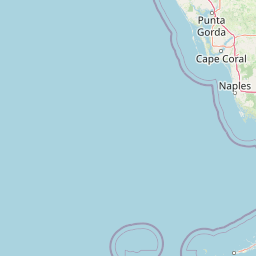
Dry Tortugas National Park encompasses a significant coastal region in Monroe County, Florida, characterized by extensive marine areas and scattered island groups. This geographic profile details the park boundaries, elevation spans between sea level and three meters, and integrated natural features including reefs and sandy keys. The data provides a comprehensive overview of the terrain and environmental composition for this remote aquatic protected area.
Related tags
Remote coral archipelago with the Western Hemisphere's largest brick fortress and the United States' only nesting colonies of several tropical bird species
Dry Tortugas National Park protects a remote chain of coral islands and extensive marine environments at the far western edge of the Florida Keys, roughly 68 miles west of Key West in the Gulf of Mexico. This archipelago represents the westernmost and most isolated extent of the Florida Keys chain, with over 99 percent of the park's 64,700 acres consisting of water surrounding seven named islands. The park's defining character emerges from its unusual combination of a largely undisturbed tropical marine ecosystem housing some of the least disturbed coral reefs in the Florida Keys, together with the monumental ruins of Fort Jefferson, the largest brick masonry structure in the Western Hemisphere. Originally designated as Fort Jefferson National Monument in 1935 through the Antiquities Act and redesignated as a national park in 1992, the preserve serves dual purposes of ecological preservation and cultural heritage protection across both terrestrial and submerged landscapes.
A coastal, island, and marine park in Monroe County, Florida
Exploring the 261.84 square kilometer marine and land extent
Lowland relief profiles and recorded natural marine features
Peaks
2.1 m
Reefs
Bays
0 m
Reefs
Beaches
Viewpoints
Tropical lowland marine and coastal island landscape categories
Islands · Coast · Beach · Reefs · Wetland
Coastal habitat · Marine habitat · Wetland
Explore the broader regional geography and connected protected landscapes surrounding the remote Florida Keys.
East

Submerged reef structures and archipelago geography
Focusing on the marine geography of the Florida Keys, this detailed record outlines the sanctuary's boundaries, ranging from Atlantic coral reefs to Gulf of Mexico seagrass flats. Understand the physical scale of this protected system, its role in coastal conservation, and the unique underwater terrain that defines the southern tip of the United States.
East
Explore its unique natural terrain and mapped boundaries.
Understand Everglades National Park as a distinct protected landscape with significant geographic features within Florida. This page offers an atlas-driven view of its protected area, detailing its mapped boundaries and the surrounding regional natural terrain. Discover the core identity of this national park through its landscape and geographic setting, providing context for broader atlas exploration.
Northeast
Subtropical mangrove landscapes within the Florida Gulf Coast region.
This marine protected area encompasses a vast sweep of sheltered coastal waters and tidal forests at the northern edge of the Ten Thousand Islands. The reserve stands as a prime example of an undisturbed subtropical estuary, characterized by continuous mangrove shorelines and intricate hydrologic networks that provide critical habitat for numerous estuarine dependent species.
East
Explore its protected status and geographic setting in Miami-Dade County.
Biscayne National Park represents a significant protected area managed as a U.S. National Park, safeguarding extensive coastal and marine environments. This page offers detailed insight into the park's geographic placement within Miami-Dade County, Florida, focusing on its mapped boundaries and the unique landscape it encompasses. Understand its ecological importance and its distinct contribution to the atlas of protected lands.
North
Protected scrub ecosystems and hydric river networks
Explore the geographic expanse of Ocala National Forest, the oldest national forest east of the Mississippi. This protected area features the vast Big Scrub, a unique sand pine ecosystem that anchors a diverse terrain of longleaf pine, blackwater rivers, and crystal-clear springs across multiple Florida counties.
Northeast

Discover protected area boundaries on Grand Bahama.
Lucayan National Park stands as a distinct national park entity within the geography of Grand Bahama. This page provides a focused atlas-style exploration of the park's protected landscape, detailing its mapped area and contributing to a structured understanding of its regional context. Delve into the geographic specifics that define Lucayan National Park as a key element of the Bahamas' protected lands, suitable for detailed map-based discovery and analysis.
East
Explore mapped boundaries and regional terrain context.
Delve into the specifics of Blue Holes National Park, a designated national park offering rich opportunities for geographic discovery. This entry provides structured information focused on its protected landscape identity, mapped outlines, and its contribution to the regional geography of Andros, Bahamas. Understand the park's unique setting through detailed map context and atlas-driven insights.
East
Mapped marine and mangrove ecosystems, plus pine forest terrain
Delve into the geographical identity of West Side National Park, a protected national park in the Bahamas renowned for its vast scale and diverse ecosystems. This landscape features significant Caribbean pine forests transitioning into extensive, intact mangrove systems along its coastlines, integrating directly with vital marine habitats. As one of the largest protected areas in the Caribbean, its ecological representation from land to sea offers a unique atlas perspective on Bahamian natural heritage and conservation.
Deepen your understanding of Dry Tortugas National Park by exploring its specific geographic context and protected area identity within Monroe County. This atlas-driven approach allows for detailed examination of its mapped boundaries and natural landscape, providing critical insights beyond simple park facts. Continue your discovery of this unique U.S. National Park's regional setting and mapped terrain.