
Mori Atlas logo
Protected areaEast Kolkata Wetlands

Tracing the intricate network of aquaculture ponds, salt marshes, and managed agricultural landscapes

East Kolkata Wetlands Protected Area: Mapping the Extensive Urban Ecosystem in West Bengal, India

(East Calcutta Wetlands)

The East Kolkata Wetlands represent a singular protected landscape where natural deltaic processes intersect with large scale human aquaculture. Spanning the eastern periphery of Kolkata in West Bengal, this unique wetland system utilizes complex canal networks and nutrient-rich settling ponds to treat municipal water while supporting significant local food production. Visitors to this atlas can study the interplay between traditional embankment-based farming and the essential ecological services provided by this sprawling, low-lying mosaic of water and agriculture.

urban wetlandssewage-fed aquacultureRamsar Sitedelta wetlandssalt marshesperi-urban ecosystems
A stylized digital illustration showing a valley with a waterfall cascading from a rocky cliff, green hills, pine trees, and a sunlit sky with clouds.

East Kolkata Wetlands

Protected area

Park overview

Structured park overview, official facts, and landscape profile for East Kolkata Wetlands

East Kolkata Wetlands park facts, protected area profile, and essential visitor context

Review the core facts for East Kolkata Wetlands, including designation, size, terrain, visitor scale, habitats, and operating context in one park-focused overview.

About East Kolkata Wetlands

The East Kolkata Wetlands occupy the eastern edge of Kolkata, in the Indian state of West Bengal, forming a vast interface between one of India's largest megacities and its surrounding countryside. The official Ramsar designation uses the name East Calcutta Wetlands, a name coined by Dhrubajyoti Ghosh, a Special Advisory figure with IUCN who worked on the wetlands while investigating what happened to the city's sewage.

The landscape is a patchwork of canals, salt marshes, sewage settling ponds, fish farms, vegetable plots, and rice paddies, all shaped by human management over generations. What distinguishes this area is that these varied habitats function together as a coherent system rather than as isolated patches. The component parts of the system interlock ecologically and economically; the same water that moves through settling ponds reaches fish ponds and farm plots, carrying nutrients that feed crops and aquatic species.

The wetlands are internationally recognized for the practical model they offer. They treat a substantial share of Kolkata's daily sewage through natural processes, using the cleansing capacity of aquatic plants, microbial activity, and successive fish ponds to break down organic matter. The resulting system supports tens of thousands of agro-workers and contributes meaningfully to the city's food supply, particularly fish.

At the same time, the wetlands remain a functioning ecological habitat. They support diverse fish populations, waterbirds, mammals, snakes, and plants adapted to edge-of-city wetlands. The juxtaposition of urban pressure, intensive human use, and ecological richness makes the East Kolkata Wetlands a unique kind of protected area: not a remote wilderness, but a living, working landscape embedded within a massive metropolitan region.

Quick facts and research context for East Kolkata Wetlands

The East Kolkata Wetlands lie east of Kolkata in West Bengal, India, covering an extensive area of canals, marshes, fish ponds, and farmland. The site has been designated as a Ramsar Wetland of International Importance since 19 August 2002, with reference number 1208.

The wetlands are characterized by a unique combination of ecological and economic functions. They naturally treat a large share of Kolkata's sewage, sustain large-scale fish and vegetable production, and support a substantial workforce of fishers and farmers. Despite ongoing urban pressures, the East Kolkata Wetlands remain one of the most studied examples of integrated urban-rural wetland management.

Protection and recognition

Documented terrestrial protection history and Ramsar designation records

East Kolkata Wetlands Protection Status and International Recognition Data

Terrestrial protection status records for East Kolkata Wetlands outline a designated establishment year of 2002 alongside verified international recognition sources. Structured preservation data provides a clear baseline for tracking official management scope and wetland designation details.

International recognition

Protection details

Protection scope
Terrestrial
Designated year
2002
Transboundary protection
No
Park context

Deeper park guide and search-rich context for East Kolkata Wetlands

East Kolkata Wetlands history, landscape, wildlife, and travel context

Explore East Kolkata Wetlands through its history, landscape character, ecosystems, wildlife, conservation priorities, cultural context, and seasonal travel timing in a structured park guide built for atlas discovery and search intent.

Why East Kolkata Wetlands stands out

The East Kolkata Wetlands are best known as a working, sewage-based ecosystem that fuses ecological function with human livelihood. They host the world's largest sewage-fed aquaculture system, with a network of fish ponds, called bheris, that use the city's wastewater as a nutrient input rather than a pollutant. The site is also recognized for the way conventional categories break down: here, natural marshes, salt pans, rice fields, and fish ponds form a single functioning landscape. This blend of ecological services, food production, and cultural practice has positioned the wetlands as a globally referenced model of urban wetland use, particularly in developing-country contexts.
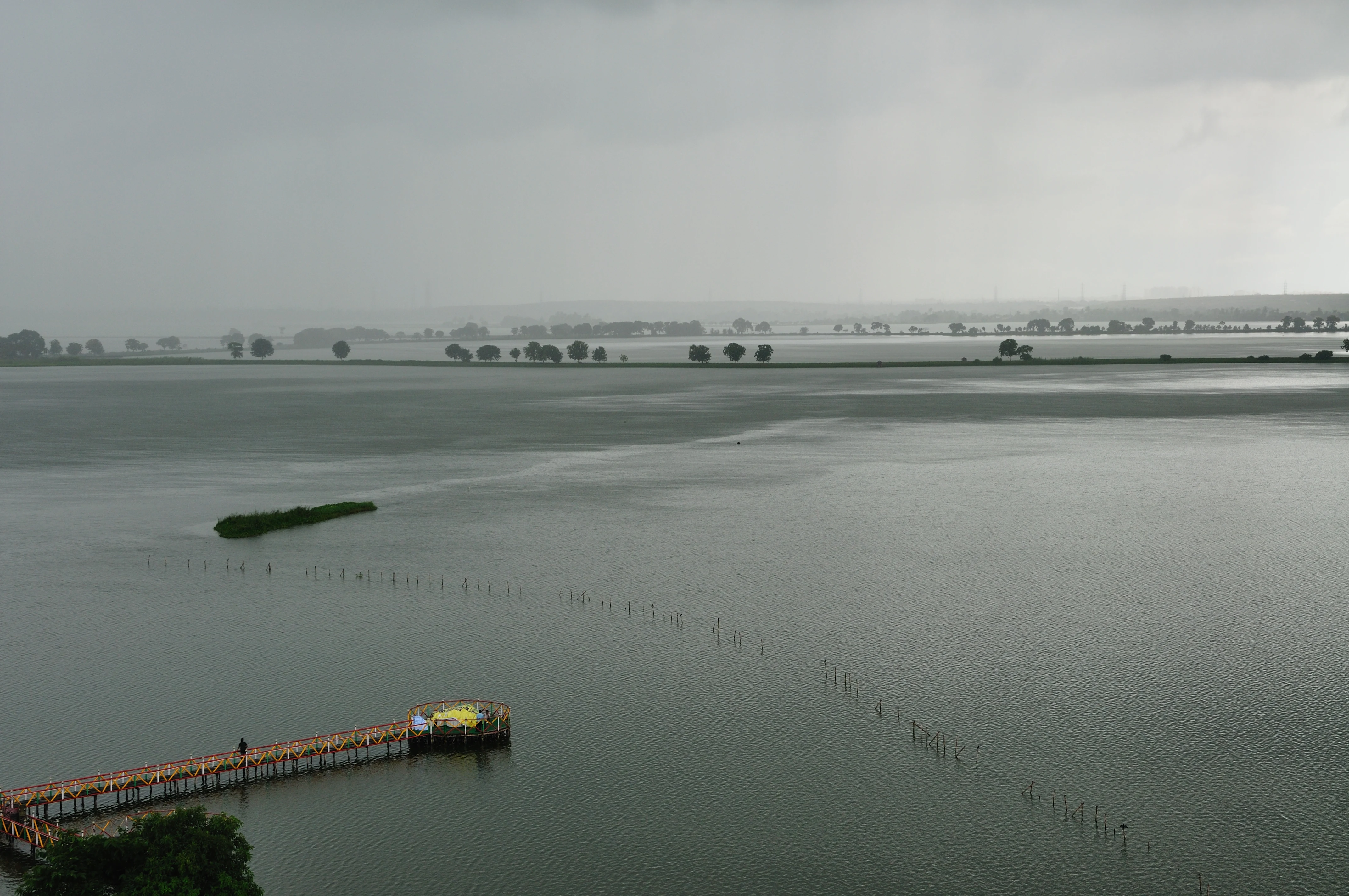
A wide, elevated view of a large, calm lake under a gray, cloudy sky. A long wooden pier extends into the water from the bottom left corner, and a series of thin, vertical posts are visible rising out of the water in a line stretching toward the horizon.
A wide view of Nalban lake under an overcast sky within the East Kolkata Wetlands.

East Kolkata Wetlands history and protected-area timeline

The modern history of the East Kolkata Wetlands is closely tied to the growth of Kolkata itself. Long before being formally recognized, the area east of the city was home to fisheries and farmland, communities that had learned to work with the marshy terrain and seasonal flows of water. The Sunderbans, the great mangrove delta to the south, historically extended considerably further inland, and traces of that older wetland landscape remain in the hydrology and soils of the East Kolkata Wetlands area.

The critical modern chapter began in the early 1990s. The West Bengal Government in 1991 allotted a large tract of the wetlands for a proposed World Trade Centre project. Concerned citizens, organized through the NGO People United for Better Living in Calcutta (PUBLIC), filed a public interest litigation in the Calcutta High Court challenging the allotment. Justice Umesh Chandra Banerjee's 1992 order is widely regarded as a landmark in Indian environmental law. The judgment laid out the functional value of wetlands and overturned the proposal, instructing that the wetlands should be preserved and not subject to reclamation or interference.

Following the ruling, the State Government under Environment Secretary Kalyan Biswas sought Ramsar recognition for the East Calcutta Wetlands, which was granted on 19 August 2002. In 2006, the East Kolkata Wetlands (Conservation and Management) Act was passed by the West Bengal legislature, a notable example of a major environmental statute enacted at the state level rather than by the central government. The Act established the East Kolkata Wetlands Management Authority (EKWMA) to oversee protection, enforcement, and management of the site.

Since then, the wetlands have continued to face encroachment pressure from urban expansion, illegal landfilling, and real estate development, particularly in sectors like Salt Lake and Rajarhat. Court interventions, including further rulings from the High Court, Supreme Court, and National Green Tribunal, have repeatedly reaffirmed the 1992 judgment and the 2006 Act as the legal foundation for the wetlands' protection.

East Kolkata Wetlands landscape and geographic character

The physical landscape of the East Kolkata Wetlands is unusually varied for an area within a megacity's periphery. Canal networks, some tree-fringed, thread through the site, linking marshy areas, fish ponds, and agricultural plots. Salt marshes and natural drainage features are interleaved with rice paddies, vegetable fields, and aquaculture basins.

The terrain is mostly low-lying, shaped by centuries of sediment deposition from the Ganges-Brahmaputra delta system. Remnants of what was once a far larger mangrove and brackish-water landscape are visible in pockets of halophytic vegetation and mangrove-associated plants, including species like Acrostichum aureum, which signals relict coastal influence.

Human modification of the landscape is integral to its character. Embankments divide the area into a patchwork of ponds of varying sizes, separated by narrow walkways and lined by palms and other trees. Coconut palms and betel nut trees dot the elevated edges, while plots of cauliflower, eggplant, pumpkin, sunflower, and sacred basil occupy the cultivated margins. Rice paddies fill the wetter, flatter interiors.

The wetlands are visually distinct from the dense urban fabric of Kolkata, and their flat, watery expanses provide a different kind of scenery: open skies, reflective water surfaces, and a horizon broken by tree lines and embankments rather than high-rises. This mixture of natural features and human-modified land shapes sits at the geographic edge of one of India's largest cities.

East Kolkata Wetlands ecosystems, habitats, and plant life

Ecologically, the East Kolkata Wetlands occupy an unusual niche. They bridge the remnant deltaic systems of the Sundarbans region in the south and the urbanized Gangetic plain in the north, supporting communities of plants and animals adapted to brackish, marshy, and nutrient-enriched conditions.

The site hosts a plant diversity shaped by both its natural and human-modified character. Around 100 plant species have been recorded in and around the wetlands, including Sagittaria montevidensis, Cryptocoryne ciliata, Cyperus species, Acrostichum aureum, and Ipomoea aquatica. Water hyacinth is widespread and is actively used by local communities as a natural erosion buffer, its dense root mats absorbing wave energy along pond edges. Terrestrial vegetation includes coconut and betel nut trees, while cultivated plots add cauliflower, eggplant, pumpkin, sunflower, and sacred basil to the visible flora.

Wetland-dependent habitats dominate much of the area. Salt marshes, settling ponds, and aquaculture basins create a gradient of salinity and nutrient conditions that supports distinct microhabitats. Microbial communities within these wetlands are unusually significant; studies have identified diverse populations of bacteria, actinobacteria, proteobacteria, and cyanobacteria, many with potential roles in degrading complex organic pollutants, recycling metals, and supporting nutrient turnover. This unseen microbial richness underpins both the sewage treatment function and the broader productivity of the system.

East Kolkata Wetlands wildlife and species highlights

The wildlife profile of the East Kolkata Wetlands reflects their position at the rural-urban interface. Fish dominate the fauna in terms of biomass and economic importance, with species like silver carp, tilapia, and various native Indian carp raised in the network of bheris. These fish farms are a defining feature of the site and the foundation of the local economy.

Approximately 20 mammal species have been reported in and around the wetlands. The area is notable as home to the marsh mongoose and the small Indian mongoose; the Salt Lake area is, in fact, the type locality for a mammalian mongoose species associated with marshy ground. Palm civets and small Indian civets are also documented around the site, indicating a degree of arboreal and edge-habitat habitat that supports medium-sized mammals even within the peri-urban landscape.

Reptiles are well represented, particularly in the waterways and embankments. Recorded snakes include the checkered keelback (Fowlea piscator), smooth water snake (Enhydris enhydris), buff striped keelback (Amphiesma stolata), and common bronzeback (Dendrelaphis tristis), each occupying distinct niches around ponds, drains, and embankments.

Avifauna is rich in the absence of complete urbanization, with over 40 bird species recorded across the wetlands. Wading birds, kingfishers, and a variety of waterbirds use the ponds and canals, and raptors range across the open spaces. However, urbanization and habitat conversion continue to drive local loss and turnover of bird species, altering the composition of the bird community over time.

East Kolkata Wetlands conservation status and protection priorities

From a conservation perspective, the East Kolkata Wetlands are remarkable because they demonstrate that a single protected area can simultaneously support biodiversity, deliver ecosystem services, and sustain human livelihoods. They were designated a Ramsar Wetland of International Importance in 2002 and have been the focus of pioneering legal protection in India.

The conservation framework around the wetlands is unusually robust. The 2006 East Kolkata Wetlands (Conservation and Management) Act provides a dedicated legal basis for protection and management, and the East Kolkata Wetlands Management Authority coordinates enforcement. Subsequent central rules, the 2017 Wetlands (Conservation and Management) Rules, also apply to the site, making it one of the few wetlands in India subject to both state-level and central-level protective frameworks.

Ecologically, the wetlands play several conservation-relevant roles at the regional scale. They act as a carbon sink, with estimates indicating meaningful sequestration capacity per hectare per year, alongside carbon uptake associated with fish harvests. Their microbial communities also have conservation and biotechnology relevance, with documented populations capable of degrading pollutants, accumulating heavy metals, and producing antimicrobials.

Yet the conservation picture is not uncomplicated. The site has experienced substantial physical reduction in area over recent decades, with encroachment, illegal landfills, and aquaculture conversion continuing to threaten its extent. Governance reviews have noted that primary stakeholders, including fisher cooperatives and sewage farmers, are underrepresented on the management authority, raising questions about the long-term balance between formal protection and on-the-ground stewardship.

East Kolkata Wetlands cultural meaning and human context

The East Kolkata Wetlands carry a strong cultural and livelihood imprint. For generations, local fishing communities and farming families have shaped the landscape, often in informal and inherited patterns. The term bheri for the sewage-fed fish ponds reflects a vocabulary of practice, not just infrastructure, embedded in local life.

The wetlands also connect to the broader ecological and cultural memory of the Sundarbans delta, which historically extended much further inland. Communities living in and around the wetlands maintain knowledge of fish husbandry, water management, and the cropping of marginal, marshy lands that has accumulated over many generations. This body of local practice now operates alongside formal legal and administrative frameworks established by the State Government and the courts, sometimes in tension, often in cooperation.

The 1992 Calcutta High Court judgment added a new layer to the cultural narrative, turning the wetlands into a symbol of public-interest environmentalism in India. The litigation led by PUBLIC gave the wetlands a place in environmental jurisprudence, and ongoing legal vigilance has become part of the identity of the site.

Top sights and standout views in East Kolkata Wetlands

Among the most distinctive features of the East Kolkata Wetlands is their scale as a working ecological system: tens of thousands of fishers, farmers, and waste workers depend directly on the complex, with fish ponds drawing on the city's wastewater as a nutrient source rather than treating it as a disposal problem.

Another distinctive trait is the legal and institutional framework around the site. From the 1992 High Court ruling to the 2006 Conservation and Management Act and the establishment of a dedicated management authority, the East Kolkata Wetlands are unusually well-anchored in formal protection compared to many urban-edge wetlands globally. The interplay of state legislation, central rules, and repeated court intervention is itself a defining characteristic.

Finally, the wetlands are a benchmark for thinking about climate, carbon, and urban food systems together; their role in carbon sequestration and in supplying a substantial share of a megacity's fish has made them a reference point in debates about working landscapes in developing-country contexts.

Best time to visit East Kolkata Wetlands

Kolkata's climate shapes when the East Kolkata Wetlands feel most accessible and impressive. The cooler, drier months from roughly November through February offer comfortable conditions for outdoor exploration, with clearer skies and less intense humidity; this is also when migrant and winter-visiting waterbirds may be more visible and local fish harvests are at seasonal highs in several parts of the complex.

The monsoon period, roughly June through September, brings heavy rain that swells the ponds and canals, intensifying the wetland character of the landscape. The waterways expand, waterbirds can be plentiful, and the surrounding vegetation is at its greenest, though humidity is high and access to some pond margins can be more difficult. The warmer months between these seasons can still be rewarding, but visitors should expect muggy conditions and time their field visits to cooler parts of the day.

For those interested in the working landscape of fish ponds and farms, visiting during or just after harvest seasons tends to bring more activity and visibility to the everyday rhythms of the wetlands.

Monthly climate preview

Long-term monthly temperature averages and precipitation totals for East Kolkata Wetlands

East Kolkata Wetlands Climate Normals, Annual Temperature and Precipitation Rhythm

Historical climate data reveals long-term monthly temperature and precipitation cycles sampled across representative coordinates within East Kolkata Wetlands. Examining the complete twelve-month normals profile provides detailed context for analyzing annual thermal and moisture patterns.
Annual mean26 °C
18 °C31 °C
Jan18°
Feb23°
Mar28°
Apr31°
May31°
Jun29°
Jul28°
Aug28°
Sep28°
Oct26°
Nov22°
Dec18°
Warmest month
April

31 °C

Coolest month
January

18.3 °C

Wettest month
July

11.1 mm/day

Driest month
December

0.3 mm/day

Park location guide

Geography guide, regional context, and park location map for East Kolkata Wetlands

East Kolkata Wetlands park geography, regions, and map view in India

Understand where East Kolkata Wetlands sits in India through a broader geographic reading of the surrounding landscape, nearby location context, and its mapped position within the national park landscape.

How East Kolkata Wetlands fits into India

India is a South Asian country bordered by the Indian Ocean, Arabian Sea, and Bay of Bengal. It shares land borders with Pakistan, China, Nepal, Bhutan, Bangladesh, and Myanmar. The country has a population of over 1.4 billion people and operates as a federal parliamentary republic with its capital in New Delhi.

Wider geography shaping East Kolkata Wetlands in India

India occupies the Indian subcontinent in South Asia, bordered by the Arabian Sea to the southwest, the Bay of Bengal to the southeast, and the Indian Ocean to the south. It shares land borders with Pakistan to the west, China, Nepal, and Bhutan to the north, and Bangladesh and Myanmar to the east. The territory also includes the Andaman and Nicobar Islands in the Indian Ocean.

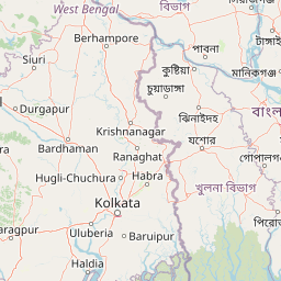
Map view of East Kolkata Wetlands

Use this park location map to pinpoint East Kolkata Wetlands in India, understand its exact geographic position, and read its mapped placement within the surrounding landscape more clearly.

Pigeon | © OpenStreetMap contributors

Location context for East Kolkata Wetlands

West Bengal

Visual reference guide to protected wetlands, aquaculture ponds, and delta terrain

East Kolkata Wetlands Photos and Landscape Scenery

Photographic records capture the complex terrain of salt marshes, fish ponds, and agricultural plots forming the East Kolkata Wetlands. Visual exploration reveals how water networks and embankments shape this protected urban ecosystem.

A wide, elevated view of a large, calm lake under a gray, cloudy sky. A long wooden pier extends into the water from the bottom left corner, and a series of thin, vertical posts are visible rising out of the water in a line stretching toward the horizon.

Park atlas

Compare regional protected areas and connected delta wetland ecosystems

Parks Near East Kolkata Wetlands and Other Protected Landscapes to Explore Next

Browse nearby national parks and protected areas sharing similar delta geography and working wetland traits. Continuing into these adjacent regional landscapes provides deeper context for urban wetland conservation.
Watercolor painting showing mangrove trees, water channels, and hills in the background
National parkWest Bengal
About 73 km away#1 closest

Southeast

Sundarbans National Park: UNESCO World Heritage Mangrove National Park in West Bengal

Explore its tidal geography and mapped protected boundaries.

Sundarbans National Park is a vital protected area on the Ganges Delta, recognized globally as the world's largest mangrove forest and a UNESCO World Heritage Site. Located in West Bengal, this national park features a unique estuarine geography characterized by intricate tidal channels and distributaries that define its landscape. Its protected boundaries safeguard a complex ecosystem, offering rich opportunities for atlas-driven exploration of its distinctive natural terrain and coastal wetland significance.

Area
1,330.1 km²
Established
1984
IUCN
II
Relief
Lowland
National parkPatuakhali District
About 186 km away#2 closest

Southeast

Kuakata National Park: Protected Landscape Identity and Geographic Atlas

Mapped boundaries and regional context within Patuakhali District.

Kuakata National Park is a significant protected area designated as a national park, offering valuable insights into the geography of Patuakhali District. This park detail page provides a structured exploration of its mapped boundaries and protected landscape characteristics, serving as a vital entry point for understanding its place within the larger atlas of global natural sites. Focus on its specific geographic setting and conservation status for detailed discovery.

Area
16.13 km²
Established
2010
IUCN
II
Relief
Lowland
Watercolor illustration showing a landscape with trees, water, and mountains
National parkMayurbhanj district
About 208 km away#3 closest

West

Simlipal National Park: National Park Protected Area in Mayurbhanj District

Mapped boundaries and regional geography of Simlipal National Park.

Simlipal National Park stands as a prominent national park, offering a rich protected area landscape within Mayurbhanj district, India. This entry provides detailed atlas-style information, focusing on the park's geographic footprint and mapped terrain. Explore the structured data that defines Simlipal National Park's identity as a protected natural landscape, ideal for understanding its place within regional geography and conservation efforts.

Area
2,750 km²
Established
1980
IUCN
II
Relief
Mountain
National parkKendrapara district
About 250 km away#4 closest

Southwest

Bhitarkanika National Park: Protected National Park in Kendrapara District

Explore its mapped boundaries and regional landscape.

Bhitarkanika National Park, a designated national park in India's Kendrapara district, offers a unique opportunity for geographic discovery. This page details the park's protected area status, its specific landscape characteristics, and its position within the regional geography. Engage with structured data about its mapped boundaries and understand its environmental context for comprehensive atlas exploration.

Area
145 km²
Established
1998
IUCN
II
Relief
Lowland
A watercolor illustration showing a winding river through a lush green mangrove forest with hills in the background.
Wildlife reserveOdisha
About 260 km away#5 closest

Southwest

Bhitarkanika Mangroves Wildlife Reserve: Coastal Geography and Protected Land Atlas

A vast estuarine wetland in the coastal state of Odisha

Bhitarkanika Mangroves represents one of the most significant estuarine systems in South Asia. This protected wildlife reserve covers a sprawling deltaic landscape characterized by tidal channels, mudflats, and intricate mangrove forests that buffer the coastline of Odisha against the Bay of Bengal.

Area
650 km²
Established
1975
Relief
Lowland
Scope
Mixed
National parkBangladesh
About 263 km away#6 closest

Northeast

Bhawal National Park: Mapped Protected Landscape in Bangladesh

Explore its national park designation and regional geography.

Bhawal National Park represents a key protected landscape within Bangladesh. This entry provides detailed information on its identity as a national park, focusing on its mapped geography and protected area significance. Users can explore the park's specific context within the broader South Asian region, understanding its contribution to the nation's conserved natural areas and gaining insight into its landscape character through an atlas-driven perspective.

Area
50.22 km²
Established
1982
IUCN
IV
Relief
Lowland
National parkBangladesh
About 268 km away#7 closest

East

Nijhum Dweep National Park: A Protected Landscape in Bangladesh's Geographic Atlas

Explore the mapped boundaries and regional setting of this national park.

Nijhum Dweep National Park is a key protected area situated within the deltaic geography of Bangladesh. This detailed entry provides insight into its mapped landscape, natural terrain, and its significance as a national park. Understand its geographic context and explore its protected boundaries as part of a broader atlas of natural areas, offering a factual basis for understanding this unique South Asian landscape.

Area
163.52 km²
Established
2001
IUCN
IV
Relief
Lowland
National parkBhaluka Upazila
About 275 km away#8 closest

Northeast

Kadigarh National Park National Park: Protected Landscape Atlas and Geographic Overview

Understand Kadigarh National Park's mapped boundaries and regional geography.

Kadigarh National Park is a distinct national park recognized for its protected status within Bhaluka Upazila, Bangladesh. This entry offers an atlas-centric perspective, detailing the park's geographic boundaries and its contribution to the regional landscape. Examine the mapped extent of this protected area and understand its role within the surrounding natural geography, providing a factual basis for exploring its protected landscape identity.

Area
3.441 km²
Established
2010
Climate
Tropical
Access
Easy access

Common questions about visiting, size, designation, and location context for East Kolkata Wetlands

East Kolkata Wetlands FAQs for park facts, access, geography, and protected area context

Find quick answers about East Kolkata Wetlands, including protected-area facts, park geography, trail and visitor context, and how the park fits into its surrounding country and regional landscape.
MoriAtlas Explorer

Continue Your Protected Areas Search Across the Global Atlas

Deepen your exploration by continuing the structured search for national parks and protected areas worldwide. Utilize the comprehensive filtering capabilities to compare different conservation landscapes and refine your understanding of global park geography. Discover more about the distribution and characteristics of protected natural areas.

Global natural geography