

Mori Atlas logo
Nature reserveEba Island Conservation Park

A study of calcarenite rock formations, tidal sandbar connections, and offshore seabird refuges.

Eba Island Conservation Park: Examining Protected Coastal Landscapes and Geography in South Australia

Eba Island Conservation Park occupies a distinct offshore position within Streaky Bay, South Australia, serving as a vital nature reserve for breeding seabird populations. This protected landscape is defined by its layered calcarenite and limestone composition, showcasing a stark contrast between wave-sculpted southern cliffs and gentle northern sandy coves. The island's geography remains intrinsically tied to the shifting coastal environment, including a notable sandbar that provides intermittent terrestrial access.

island conservation parkstrict nature reserveseabird breeding habitatcalcarenite geologylimestone coastEyre Peninsula

Eba Island Conservation Park

Nature reserve

Park overview

Structured park overview, official facts, and landscape profile for Eba Island Conservation Park

Eba Island Conservation Park park facts, protected area profile, and essential visitor context

Review the core facts for Eba Island Conservation Park, including designation, size, terrain, visitor scale, habitats, and operating context in one park-focused overview.

About Eba Island Conservation Park

Eba Island Conservation Park protects one of the small inshore islands associated with the western coast of Eyre Peninsula in South Australia. Its offshore setting, combined with its position inside the more sheltered waters of Streaky Bay, gives the reserve a distinctive character among South Australian island parks.

The park has been constituted to conserve island habitat and the seabird breeding colonies that depend on it. Its small footprint and strict reserve status reflect its role less as a visitor destination and more as a sanctuary for wildlife and intact coastal landforms that are vulnerable to disturbance or invasive species.

The island also carries traces of past human use, including cleared areas and an abandoned house, evidence of a former attempt at agricultural activity. Native vegetation has since reclaimed much of this land, although introduced plants such as African boxthorn remain a management concern.

Today the park sits within a network of protected islands along the western Eyre Peninsula, recognised for their role in maintaining seabird populations and preserving unusual limestone and calcarenite coastal environments along the South Australian coast.

Quick facts and research context for Eba Island Conservation Park

Eba Island Conservation Park is an IUCN Category Ia strict nature reserve on a small offshore island in South Australia, about 4 kilometres south of Perlubie Hill and 700 metres from the mainland near Streaky Bay. The reserve covers roughly 134 hectares and is managed by the South Australian Department for Environment and Water. The island's calcarenite base, capped in limestone, supports remnant native vegetation, seabird breeding colonies, and a history of brief agricultural use that has since been reclaimed by native plants.

Protection and recognition

Explore terrestrial protection metrics and official conservation status records

Eba Island Conservation Park Protection Status and Mapped Geography

Eba Island Conservation Park maintains a defined terrestrial protection scope within its regional landscape. Structured records outline the documented designation status and administrative framework governing the protected area.

Protection details

Protection scope
Terrestrial
Transboundary protection
No
Park context

Deeper park guide and search-rich context for Eba Island Conservation Park

Eba Island Conservation Park history, landscape, wildlife, and travel context

Explore Eba Island Conservation Park through its history, landscape character, ecosystems, wildlife, conservation priorities, cultural context, and seasonal travel timing in a structured park guide built for atlas discovery and search intent.

Why Eba Island Conservation Park stands out

Eba Island Conservation Park is best known for its offshore island setting within Streaky Bay, where calcarenite and limestone have been shaped by waves into blowholes, jagged ridges, and sheltered sandy coves. It is valued primarily as a refuge for seabird breeding colonies and as one of a group of small island conservation parks along the western edge of Eyre Peninsula.

Eba Island Conservation Park history and protected-area timeline

Eba Island was once used for agriculture, an attempt that left lasting physical traces on the otherwise natural island. An abandoned house and the remains of broken fence lines survive from this period, although native vegetation has slowly reclaimed the cleared grasslands.

The island was first formally protected as a Fauna Reserve in 1966. It was later constituted as Eba Island Conservation Park by statute in 1972, placing it within South Australia's formal system of conservation parks. Today the park is classified as an IUCN Category Ia protected area, reflecting its strict nature reserve status.

Eba Island Conservation Park landscape and geographic character

Eba Island is a small, low-lying island that is geologically simple but visually distinct. The whole island is composed of calcarenite, a relatively soft sedimentary rock made of cemented sand grains, frequently overlaid by a harder limestone capping. This layered structure has shaped every notable feature on the island.

On the more exposed southwestern side, incoming waves have undercut the calcarenite wall and sculpted a rugged coastal edge marked by blowholes, scalloped ridges, and thin blades of jagged rock. The northern side, sheltered within Streaky Bay, is gentler, where the calcarenite bed is softened into small sandy coves punctuated by rocky outcrops that emerge as low headlands.

At low tide, a sandbar connects the island to the mainland, a feature that has shaped both the ecology and the past human use of the area, allowing terrestrial access that is not always possible at higher water levels.

Eba Island Conservation Park ecosystems, habitats, and plant life

Although small in area, Eba Island supports an island ecosystem shaped by isolation, salt exposure, and a geology dominated by calcarenite and limestone. Native vegetation persists across parts of the island, including creeping boobialla, a low, mat-forming shrub that is listed as Rare under South Australia's National Parks and Wildlife Act 1972.

The ecological character of the park also reflects past disturbance. Former agricultural clearing left open grasslands that native vegetation is slowly reclaiming, while the introduced African boxthorn has become established on the island and remains a management concern. The mix of recovering native cover, persistent weeds, and rugged coastal terrain gives the reserve a transitional island ecology typical of inshore South Australian islands.

Eba Island Conservation Park wildlife and species highlights

Eba Island Conservation Park is primarily recognised for its role in supporting sea bird breeding colonies, one of the main reasons the island was brought under formal protection. The combination of cliff edges, exposed rock, and quieter northern coves provides varied nesting conditions for seabirds using the sheltered waters of Streaky Bay.

Terrestrial fauna is also influenced by the island's accessibility. Red fox tracks have been recorded on Eba Island, a concern for ground-nesting birds and small native animals, and one of the reasons the area's strict reserve status and ongoing management matter. At low tide, a sandbar links the island to the mainland, allowing terrestrial animals to cross between them and reinforcing the importance of protecting this island as part of a broader coastal ecosystem. A fuller species list for the island is documented in the Island Parks of Western Eyre Peninsula Management Plan.

Eba Island Conservation Park conservation status and protection priorities

Eba Island Conservation Park was established specifically to conserve island habitat within Streaky Bay and the seabird breeding colonies that rely on it. Its status as an IUCN Category Ia strict nature reserve indicates that protection, rather than public recreation, is the primary objective of management.

The reserve is part of a wider network of island parks along the western Eyre Peninsula managed under the Island Parks of Western Eyre Peninsula Management Plan, which provides guidance on issues such as invasive species, fox impacts, and the recovery of native vegetation. The presence of African boxthorn, evidence of red fox visitation, and the accessibility provided by the low-tide sandbar all highlight ongoing conservation pressures on the park.

Protection of the island also preserves an unusually intact example of calcarenite and limestone coastal landforms along this stretch of the South Australian coast, supporting both ecological and geomorphological values in a single small reserve.

Eba Island Conservation Park cultural meaning and human context

The most visible traces of human history on Eba Island relate to a brief period of agricultural use that has since been abandoned. An old house and broken fence lines remain as quiet reminders of this short-lived settlement attempt, and the gradual return of native vegetation to the cleared grasslands reflects the island's slow reversion to a wilder state.

The naming of Eba Island itself is uncertain; one account links it to a clerk in the South Australian Department of Lands, while another suggests it was named after an acquaintance of Governor MacDonnell. Either way, the island is a small but distinctive part of the cultural and natural heritage of the Streaky Bay region.

Top sights and standout views in Eba Island Conservation Park

Eba Island Conservation Park stands out for its combination of seabird breeding habitat, exposed calcarenite coastal landforms, and strict nature reserve protection within South Australia's island park system. Its small scale and offshore position give it a focused conservation role, while the contrast between rugged wave-carved southern shores and sheltered northern coves gives the island a varied and memorable coastal character.

Best time to visit Eba Island Conservation Park

Seasonal conditions around Streaky Bay strongly influence the character of any visit to Eba Island Conservation Park. The cooler months of late autumn, winter, and early spring generally bring calmer seas and milder temperatures, which can improve access along the protective northern coves and make the island's calcarenite landforms easier to observe, while the warmer summer months bring stronger swells that emphasise the wave-carved features on the southern flanks, though conditions can be less settled for shoreline exploration. Wildlife interest, including seabird breeding activity, is shaped by annual breeding cycles that should be considered when planning any visit.
Monthly climate preview

Long-term temperature ranges and monthly precipitation averages for South Australia

Eba Island Conservation Park Climate Normals and Annual Weather Patterns

Historical monitoring data for Eba Island Conservation Park reveals a measured annual cycle of temperature shifts and low precipitation rates across twelve distinct months. Reviewing the complete monthly climate profile provides deeper context for long-term meteorological trends at a representative coordinate.
Annual mean18 °C
12 °C24 °C
Jan24°
Feb24°
Mar22°
Apr19°
May15°
Jun12°
Jul12°
Aug13°
Sep15°
Oct18°
Nov20°
Dec22°
Warmest month
January

24.3 °C

Coolest month
July

11.7 °C

Wettest month
July

1.3 mm/day

Driest month
January

0.4 mm/day

Park location guide

Geography guide, regional context, and park location map for Eba Island Conservation Park

Eba Island Conservation Park park geography, regions, and map view in Australia

Understand where Eba Island Conservation Park sits in Australia through a broader geographic reading of the surrounding landscape, nearby location context, and its mapped position within the national park landscape.

How Eba Island Conservation Park fits into Australia

Australia is a constitutional monarchy and federal parliamentary democracy comprising six states and ten territories. With a population of nearly 28 million, it is one of the world's most urbanised countries, with most people concentrated on the eastern seaboard. The country has a high Human Development Index and is known for its cultural diversity, ancient Aboriginal heritage, and unique wildlife.

Wider geography shaping Eba Island Conservation Park in Australia

Australia occupies the entire Australian continent, the island of Tasmania, and numerous smaller islands. It is the world's flattest and driest inhabited continent, featuring vast deserts in the interior (the Outback), tropical rainforests along the eastern coast, and a coastline bordering the Indian and Pacific Oceans.

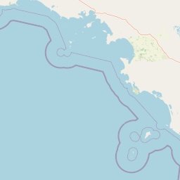
Map view of Eba Island Conservation Park

Use this park location map to pinpoint Eba Island Conservation Park in Australia, understand its exact geographic position, and read its mapped placement within the surrounding landscape more clearly.

Pigeon | © OpenStreetMap contributors

Location context for Eba Island Conservation Park

South Australia
Natural feature types

Browse the Named Natural Features and Coastal Geography of Eba Island Conservation Park

View the categorized landforms and terrain data for Eba Island Conservation Park. MoriAtlas provides structured access to the island's geological features, including coastal blowholes, rocky ridges, and sheltered sandy coves across its island environment.
Park atlas

Compare regional coastal reserves and nearby island sanctuaries across South Australia

Explore Protected Areas and Other Parks Near Eba Island Conservation Park

Browsing other protected areas near Eba Island Conservation Park reveals connected coastal habitats and similar island reserves along the western edge of Eyre Peninsula. Expanding the geographic comparison helps trace regional conservation patterns and sheltered marine ecosystems across the surrounding limestone coast.
Nature reserveSouth Australia
About 35 km away#1 closest

South

Calpatanna Waterhole Conservation Park: Protected Geography and Coastal Reserve Mapping

Nature reserve landscape within the South Australian Eyre Peninsula

Calpatanna Waterhole Conservation Park represents a specialized protected environment within South Australia. Centred on its namesake waterhole, the area preserves a distinctive mosaic of seasonal saline lagoons and hardy mallee eucalyptus scrub. This reserve highlights the ecological and geographic character of the Eyre Peninsula, where low undulating terrain supports unique, salt-adapted vegetation communities.

Area
36.44 km²
Established
1974
IUCN
Ia
Relief
Lowland
Protected areaSouth Australia
38 km away#2 closest

South

Cape Blanche Conservation Park: Eyre Peninsula Coastal Protected Landscape Map

Regional geography and conservation coastal terrain

Located on the remote western coast of the Eyre Peninsula, Cape Blanche Conservation Park serves as a dedicated sanctuary for coastal raptors and migratory birds. This protected area features a rugged intersection of limestone cliffs, sandy bays, and native coastal flora, providing an essential ecological corridor within the South Australian reserve system.

Area
810 km²
Established
2012
IUCN
III
Scope
Terrestrial
Wildlife reserveSouth Australia
66 km away#3 closest

East

Gawler Ranges Conservation Park: Mallee Landscapes and Regional Protected Areas

Semi-arid habitat and rocky terrain of South Australia

Gawler Ranges Conservation Park protects a core area of tree mallee woodland and rocky rises near the southern fringe of the Gawler Ranges. This wildlife reserve serves as an essential anchor for regional biodiversity on the Eyre Peninsula, offering a look at the arid-adapted vegetation and weathered geological structures that define this remote section of South Australia.

Area
154.8 km²
Established
1993
IUCN
VI
Relief
Upland
National parkSouth Australia
83 km away#4 closest

East

Gawler Ranges National Park: South Australia's Mapped Protected National Landscape

Explore the geography and protected area context of this national park.

Gawler Ranges National Park stands as a significant protected area within the geographic expanse of South Australia. Designated as a national park, it offers valuable insights into Australia's conservation landscapes and regional geography. Users can explore its mapped boundaries and understand its unique role within the national park system, making it a key point for structured geographic study and atlas-based discovery of protected lands.

Area
1,628.75 km²
Established
2002
IUCN
VI
Relief
Mountain
Wildlife reserveSouth Australia
About 113 km away#5 closest

Southeast

Cocata Conservation Park: Eyre Peninsula Protected Wildlife Reserve and Landscape Map

Geographic overview of South Australian conservation lands.

Cocata Conservation Park encompasses a vast semi-arid expanse on the Eyre Peninsula, characterized by gently undulating plains, calcrete-capped terrain, and open salt flats. Gain insights into the physical geography and habitat distribution of this important South Australian wildlife reserve through detailed regional mapping.

Area
167.62 km²
Established
1993
IUCN
VI
Scope
Terrestrial
National parkSouth Australia
126 km away#6 closest

Northeast

Lake Gairdner National Park: National Park with Unique South Australian Geography and Mapped Boundaries

South Australian protected area with distinct landscape characteristics.

Lake Gairdner National Park serves as a key protected area within the geographic expanse of South Australia. This national park offers a unique focus for atlas exploration, highlighting its specific landscape features and mapped boundaries. Users can delve into the park's protected status and its contribution to the regional geography, providing valuable context for understanding Australia's diverse natural protected lands and their cartographic representation.

Area
5,531.77 km²
Established
1991
IUCN
VI
Relief
Lowland
Wildlife reserveSouth Australia
About 127 km away#7 closest

Southeast

Dakalanta Sanctuary: A Private Wildlife Reserve on the Northern Eyre Peninsula

Mapped regional geography and conservation habitat profiles

Dakalanta Sanctuary provides a significant example of private land conservation in South Australia. Covering 130 square kilometres of low hills and stabilized dunes, this reserve focuses on restoring native vegetation after past pastoral use. The area is vital for safeguarding semi-arid habitats like mallee woodlands, playing an active role in regional biodiversity protection and habitat connectivity.

Area
130 km²
Established
2002
Relief
Upland
Access
Access unknown
Nature reserveSouth Australia
137 km away#8 closest

Northwest

Chadinga Conservation Park: Coastal Dunes and Salt Lake Geography in South Australia

Remote protected dune systems and arid saline landscapes

Chadinga Conservation Park protects a significant stretch of coastal dune country west of Lake MacDonnell. This arid landscape, defined by salt lakes and mallee scrub, serves as a crucial habitat for rare species, offering a raw and undisturbed look at the coastal geography of the South Australian coastline.

Area
118.54 km²
Established
1993
IUCN
VI
Relief
Lowland

Common questions about visiting, size, designation, and location context for Eba Island Conservation Park

Eba Island Conservation Park FAQs for park facts, access, geography, and protected area context

Find quick answers about Eba Island Conservation Park, including protected-area facts, park geography, trail and visitor context, and how the park fits into its surrounding country and regional landscape.
MoriAtlas Explorer

Continue Your Protected Areas Search Across the Global Atlas

Deepen your exploration by continuing the structured search for national parks and protected areas worldwide. Utilize the comprehensive filtering capabilities to compare different conservation landscapes and refine your understanding of global park geography. Discover more about the distribution and characteristics of protected natural areas.

Global natural geography