
Mori Atlas logo
Nature reserveElkhorn Slough National Estuarine Research Reserve

Understanding the tidal salt marsh dynamics and habitat structure of this protected California estuary

Elkhorn Slough National Estuarine Research Reserve: Geography and Protected Coastal Landscapes

Elkhorn Slough National Estuarine Research Reserve represents a significant protected area along the Monterey Bay coastline of California. This research-focused nature reserve preserves one of the most extensive tidal salt marsh systems in the state, offering a study of shifting mudflats, tidal channels, and surrounding oak woodland ridges. The reserve serves as a critical model for estuarine conservation, mapping the intersection of freshwater wetlands and marine influenced coastal environments.

estuarytidal salt marshMonterey Baycoastal wetlandbirdwatchingmarine wildlife
A flat vector-style digital illustration showing a mountainous valley with a river, a waterfall, and dense pine forests under a pale sky.

Elkhorn Slough National Estuarine Research Reserve

Nature reserve

Park overview

Structured park overview, official facts, and landscape profile for Elkhorn Slough National Estuarine Research Reserve

Elkhorn Slough National Estuarine Research Reserve park facts, protected area profile, and essential visitor context

Review the core facts for Elkhorn Slough National Estuarine Research Reserve, including designation, size, terrain, visitor scale, habitats, and operating context in one park-focused overview.

About Elkhorn Slough National Estuarine Research Reserve

The Elkhorn Slough National Estuarine Research Reserve protects a representative portion of one of California's most important coastal wetland systems. Situated on the central shore of Monterey Bay near Watsonville, the reserve sits within the broader Elkhorn Slough, a tidal estuary that drains agricultural land, freshwater streams, and upland habitats into Monterey Bay. Its location places it on a stretch of coastline renowned for biodiversity, marine productivity, and conservation significance on the California coast.

The reserve's identity is fundamentally tied to its salt marsh ecosystem. Tidal channels meander through expanses of pickleweed-dominated marsh, while mudflats exposed at low tide provide rich feeding areas for shorebirds and fish. Along the edges of the marsh, riparian and oak woodland habitats add vertical structure and freshwater influence, creating transitional zones that support a wide variety of species. Together, these environments form a working example of how estuaries function as nurseries, filters, and buffers between land and sea.

As a member of the National Estuarine Research Reserve system, the site carries a dual role. It is a place of active scientific investigation, where researchers monitor water quality, climate impacts, and ecosystem change over time, and it is a place of public engagement, where educational programs, exhibits, and trails connect visitors to the workings of a coastal estuary. This blend of research, conservation, and education defines what makes the Elkhorn Slough Reserve distinctive among California's network of protected natural areas.

Quick facts and research context for Elkhorn Slough National Estuarine Research Reserve

The Elkhorn Slough National Estuarine Research Reserve is located at 1700 Elkhorn Road near Watsonville, California, on the central shore of Monterey Bay about 100 miles south of San Francisco. The reserve covers roughly 1,700 acres of tidal salt marsh, mudflats, and adjacent uplands, and is part of the larger Elkhorn Slough watershed.

Protection and recognition

Examine the documented protection status and management scope for this protected area.

Elkhorn Slough National Estuarine Research Reserve Protection Status and Governance

Elkhorn Slough National Estuarine Research Reserve maintains a mixed protection scope governed by structured conservation frameworks. Documented records provide verified administrative details and official designation data without relying on external assumptions.

Protection details

Protection scope
Mixed
Park context

Deeper park guide and search-rich context for Elkhorn Slough National Estuarine Research Reserve

Elkhorn Slough National Estuarine Research Reserve history, landscape, wildlife, and travel context

Explore Elkhorn Slough National Estuarine Research Reserve through its history, landscape character, ecosystems, wildlife, conservation priorities, cultural context, and seasonal travel timing in a structured park guide built for atlas discovery and search intent.

Why Elkhorn Slough National Estuarine Research Reserve stands out

Elkhorn Slough Reserve is best known for its extensive tidal salt marsh ecosystem, one of the most ecologically significant estuaries on the central California coast. It is widely recognized as a hub for estuarine research and environmental education within the NOAA National Estuarine Research Reserve system. The reserve is also well known for its rich and easily observable wildlife, including harbor seals, sea otters, brown pelicans, and seasonal congregations of migratory birds. Its combination of protected habitat, public trails, and active science programs gives it a distinctive identity among California coastal reserves.
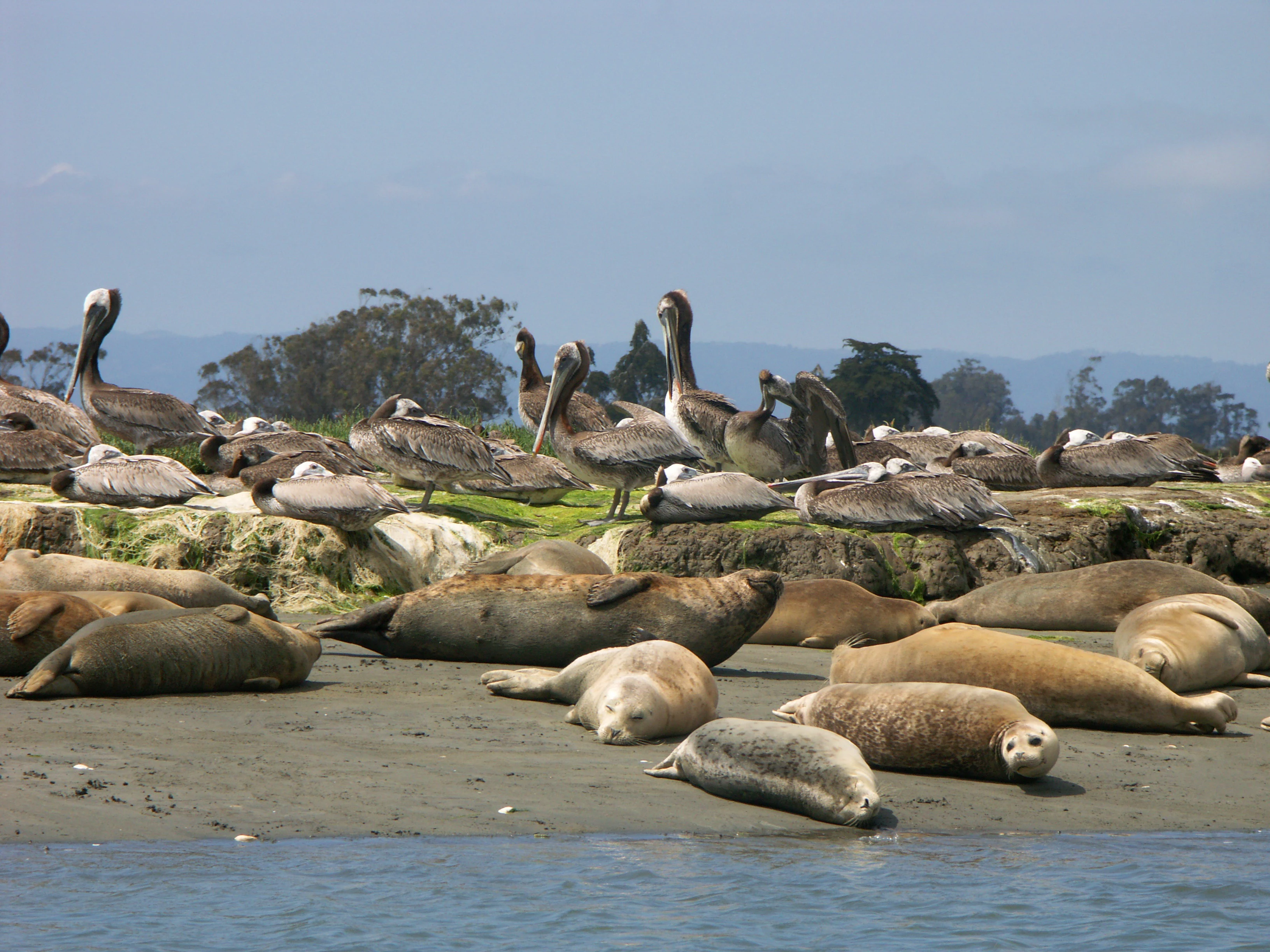
A group of harbor seals resting on a sandy beach with brown pelicans perched on a grassy bank in the background.
Harbor seals and pelicans resting on the shore at Elkhorn Slough.

Elkhorn Slough National Estuarine Research Reserve history and protected-area timeline

The Elkhorn Slough National Estuarine Research Reserve was established as part of the National Estuarine Research Reserve system administered by the National Oceanic and Atmospheric Administration. Its creation reflected a broader national effort to conserve representative estuarine habitats and to support long-term research and monitoring in these ecologically vital zones.

Management of the reserve is carried out through the California Department of Fish and Wildlife, which oversees the site as the Elkhorn Slough Ecological Reserve. This partnership between federal program designation and state-level management continues to shape how the reserve balances research, habitat protection, and public access.

Elkhorn Slough National Estuarine Research Reserve landscape and geographic character

The landscape of the Elkhorn Slough Reserve is defined by water, marsh, and the slow transitions between them. The reserve's central feature is its tidal salt marsh, shaped by the daily rhythm of tides moving in and out of Elkhorn Slough. Channels and sloughs cut through the marsh, creating patterns of mudflat, channel edge, and vegetated plain that shift between submerged and exposed conditions throughout the tidal cycle.

Around the marsh, the terrain rises gently into upland edges that include freshwater wetland margins, riparian corridors, and patches of oak woodland. These higher, drier zones frame the wet interior of the reserve and provide important habitat structure alongside the estuarine core. The result is a landscape where flat, open marshland meets wooded ridges and creeks, offering both sweeping vistas and enclosed, channel-level scenery along the trails.
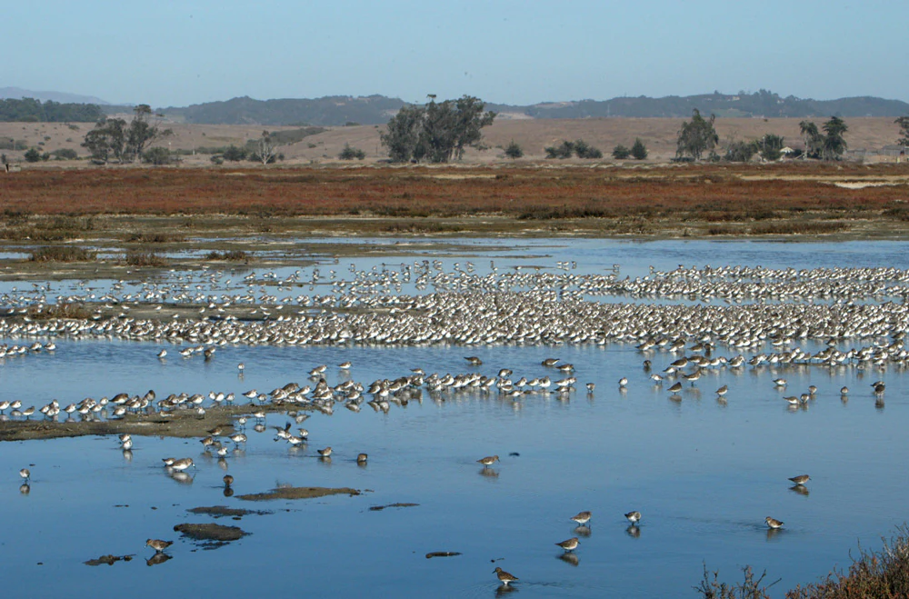
A wide, horizontal view of a large flock of shorebirds foraging in shallow water in a coastal marsh habitat under a clear blue sky.
A large flock of shorebirds congregating in the tidal marshes of Elkhorn Slough.

Elkhorn Slough National Estuarine Research Reserve ecosystems, habitats, and plant life

The ecological identity of the Elkhorn Slough Reserve centers on its estuarine habitats. Salt marsh, dominated by hardy halophytic vegetation, anchors the system and gives structure to the soft sediments of the slough. Tidal mudflats, channels, and shallow waters extend the marsh's ecological reach, while freshwater inflows from the surrounding watershed influence salinity gradients and nutrient cycling within the estuary.

The reserve's mosaic also includes riparian areas, seasonal wetlands, and oak-dominated uplands along the slough's margins. This combination of estuarine, freshwater, and terrestrial habitats creates a gradient of conditions that supports a notably high diversity of plants, invertebrates, fish, and birds for a site of its size.
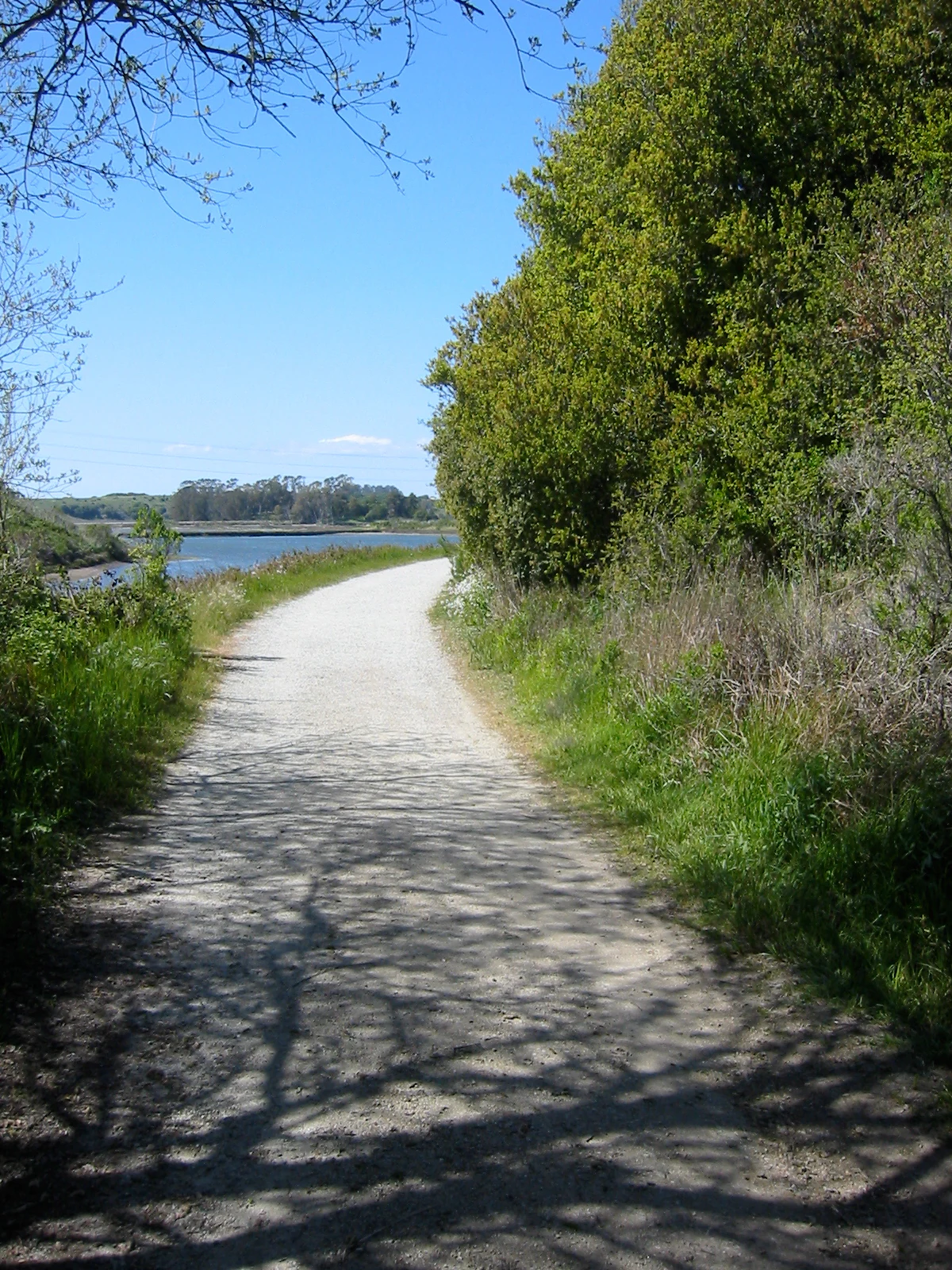
A dirt hiking path bordered by trees on the right and grassy marshlands leading toward a body of water in the distance.
A dirt hiking trail winding through the salt marsh and coastal landscape at Elkhorn Slough.

Elkhorn Slough National Estuarine Research Reserve wildlife and species highlights

Wildlife observation is one of the most prominent features of a visit to the Elkhorn Slough Reserve. Harbor seals regularly haul out along channels and near the reserve's piers, while sea otters forage in the nearby waters of Monterey Bay and the slough itself. Brown pelicans are a familiar sight, gliding low over the water and roosting along the shoreline.

The reserve is also a significant site for birdlife, supporting both resident species and seasonal migrants. Shorebirds probe the mudflats, raptors hunt over the marsh edges, and songbirds occupy the wooded uplands. Leopard sharks, an array of fish species, and other marine life inhabit the slough's waters, contributing to the reserve's reputation as a productive place to observe estuarine wildlife in close range.

Elkhorn Slough National Estuarine Research Reserve conservation status and protection priorities

Conservation is central to the mission of the Elkhorn Slough Reserve. The site exists to protect and study the salt marsh and surrounding watershed ecosystems that are characteristic of the California coast but increasingly rare due to historic wetland loss and continuing pressure from land use and climate change.

Through its role in the National Estuarine Research Reserve system, the reserve contributes to long-term monitoring of estuarine health, water quality, and climate impacts. Its programs work toward conserving habitats and wildlife, restoring ecological function where possible, and providing data and guidance that inform broader estuarine management along the Pacific coast.

Top sights and standout views in Elkhorn Slough National Estuarine Research Reserve

The reserve's standout qualities include its extensive tidal salt marsh, its accessibility for wildlife viewing, and its strong identity as both a research and educational site. Visitors can walk several miles of trails from the visitor center and encounter seals, sea otters, brown pelicans, and diverse birdlife within a single outing.

Its combination of active scientific monitoring, habitat protection, and public programming gives it a distinctive profile among California's coastal reserves. Rather than being solely a wilderness area, Elkhorn Slough Reserve is a place where conservation science and public engagement operate side by side at the edge of Monterey Bay.

Best time to visit Elkhorn Slough National Estuarine Research Reserve

The reserve can be visited throughout the year, with conditions shaped largely by tides, weather, and seasonal wildlife patterns. Cooler months often bring increased presence of migratory waterbirds and quieter, crisper conditions along the marsh, while the longer days of spring and summer favor active wildlife viewing, including seal pups along channels and pelicans feeding in the bay.

Wildlife viewing tends to be richest at lower tides, when mudflats are exposed and channels concentrate fish, birds, and marine mammals. Because coastal weather can shift quickly, layered clothing and flexibility in timing help make the most of a visit in any season.

Monthly climate preview

Examine long-term representative temperature ranges and monthly precipitation patterns across the reserve

Elkhorn Slough National Estuarine Research Reserve Climate Normals and Temperature Rhythms

Historical coordinate data reveals measured shifts in mean monthly temperature and daily precipitation at Elkhorn Slough National Estuarine Research Reserve from 1991 to 2020. Reviewing the comprehensive twelve-month climate profile provides deeper context for long-term environmental patterns across the protected landscape.
Annual mean14 °C
10 °C18 °C
Jan10°
Feb10°
Mar11°
Apr12°
May14°
Jun16°
Jul18°
Aug18°
Sep18°
Oct16°
Nov12°
Dec10°
Warmest month
August

18.1 °C

Coolest month
December

9.5 °C

Wettest month
February

3.8 mm/day

Driest month
July

0 mm/day

Park location guide

Geography guide, regional context, and park location map for Elkhorn Slough National Estuarine Research Reserve

Elkhorn Slough National Estuarine Research Reserve park geography, regions, and map view in United States of America

Understand where Elkhorn Slough National Estuarine Research Reserve sits in United States of America through a broader geographic reading of the surrounding landscape, nearby location context, and its mapped position within the national park landscape.

How Elkhorn Slough National Estuarine Research Reserve fits into United States of America

The United States of America is a federal presidential republic and one of the world's largest countries by area and population. It consists of 50 states across a vast territory spanning multiple time zones, with its capital in Washington, D.C. and largest city in New York City. The nation has a diverse economy, influential political system, and significant cultural and military presence globally.

Wider geography shaping Elkhorn Slough National Estuarine Research Reserve in United States of America

The United States occupies a vast territory in North America, bordered by Canada to the north and Mexico to the south. The 48 contiguous states stretch from the Atlantic to the Pacific Ocean, while Alaska occupies the northwestern region and Hawaii is an archipelago in the Pacific. The country encompasses diverse terrain including the Rocky Mountains, Appalachian Mountains, Great Plains, and extensive river systems.

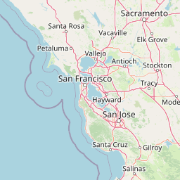
Map view of Elkhorn Slough National Estuarine Research Reserve

Use this park location map to pinpoint Elkhorn Slough National Estuarine Research Reserve in United States of America, understand its exact geographic position, and read its mapped placement within the surrounding landscape more clearly.

Pigeon | © OpenStreetMap contributors

Location context for Elkhorn Slough National Estuarine Research Reserve

California

Visualizing the tidal salt marshes, wetland channels, and coastal habitats of Monterey Bay

Elkhorn Slough National Estuarine Research Reserve Photos and Landscape Scenery

Visual records illustrate the expansive tidal salt marshes, winding water channels, and upland oak woodlands defining the protected estuarine environment. Examining these field photographs helps researchers and visitors understand the distinctive coastal terrain and diverse wildlife habitats preserved along Monterey Bay.

A group of harbor seals resting on a sandy beach with brown pelicans perched on a grassy bank in the background.

A wide shot of a long wooden pier with a railing stretching across a calm estuary, reflecting in the water, with dense green trees and shrubs lining the banks under a clear blue sky.

A wide, horizontal view of a large flock of shorebirds foraging in shallow water in a coastal marsh habitat under a clear blue sky.

A dirt hiking path bordered by trees on the right and grassy marshlands leading toward a body of water in the distance.

Park atlas

Compare nearby coastal reserves, tidal wetlands, and connected natural landscapes

Parks Near Elkhorn Slough National Estuarine Research Reserve and Regional Protected Areas

Browsing other protected areas near Elkhorn Slough National Estuarine Research Reserve reveals a wider network of coastal wetlands and tidal habitats along the central shore. Regional park comparison provides deeper context into California estuarine conservation and surrounding watershed geography.
A soft watercolor painting of a shoreline with gentle green hills and pale purple water against a white background.
Marine protected areaCalifornia
About 1.2 km away#1 closest

West

Monterey Bay National Marine Sanctuary: California Marine Protected Area and Coastal Atlas

Mapping deep submarine canyons and expansive Pacific coastal ecosystems.

Monterey Bay National Marine Sanctuary represents one of the most biologically significant marine protected areas in the United States. Spanning 276 miles of California shoreline, the sanctuary encompasses varied aquatic terrain including towering kelp forests, rocky reefs, and the massive Monterey Submarine Canyon. This protected marine landscape serves as a crucial region for oceanic research and environmental conservation.

Area
15,780 km²
Established
1992
Relief
Mixed relief
Climate
Mediterranean
Watercolor painting of a mountain landscape with forested foothills and a valley in the foreground.
Protected landscapeCalifornia
About 44 km away#2 closest

Southeast

Los Padres National Forest: Geography and Protected Landscape Map of Central California

Extensive wilderness corridors and high mountain ridges

Spanning from the Big Sur coastline to the interior ranges of the Santa Lucia and San Rafael mountains, Los Padres National Forest represents a significant protected area in California. The region contains deep gorges, forest-covered canyons, and high-altitude pine ridges that provide essential habitat and support major river headwaters.

Area
7,700 km²
Established
1936
Relief
Mountain
Climate
Mediterranean
National parkCalifornia
About 53 km away#3 closest

Southeast

Pinnacles National Park: California National Park Geographic Discovery and Map Context

Explore unique protected landscape and regional terrain.

Delve into the protected landscape of Pinnacles National Park, a significant natural area within California. This page offers an atlas-centered view of its unique geological formations and mapped terrain, providing essential context for understanding its geographic identity. Explore the park's specific landscape characteristics and its relation to the broader regional geography and protected areas.

Area
107.67 km²
Established
2013
IUCN
II
Visitors
275K annual
Marine protected areaCalifornia
About 127 km away#4 closest

Northwest

Greater Farallones National Marine Sanctuary: Protected Marine Geography and Atlas Data

Essential marine protected area off the coast of California.

Greater Farallones National Marine Sanctuary protects a vital network of oceanic habitats off California, including sandy beaches, tidal flats, subtidal reefs, and open ocean waters. This marine protected area serves as a critical link in the Pacific coast's network of conservation landscapes, offering a deep look at the geographic connectivity between coastal estuaries and offshore continental shelf environments.

Area
8,530 km²
Established
1981
Relief
Lowland
Climate
Mediterranean
A horizontal watercolor painting showing a rolling landscape with a pond in the foreground, small hills in the background, and soft-colored wildflowers on the banks.
Protected landscapeCalifornia
About 128 km away#5 closest

Northwest

Golden Gate National Recreation Area: A Mapped Protected Landscape in California

Coastal geography and historical park terrain overview

An expansive network of protected lands encompassing Pacific shorelines, Marin headlands, and urban forest ecosystems. This recreation area provides a detailed look at the geographic connectivity between coastal redwood groves, military fortifications, and restored wetland corridors within the California Bay Area region.

Area
332.31 km²
Established
1972
IUCN
V
Visitors
15M annual
Watercolor painting of soft, rolling green hills and landscape against a pale background.
Protected landscapeMarin County
About 148 km away#6 closest

Northwest

Point Reyes National Seashore: Exploring the Protected Landscapes of Marin County

Geology, coastal estuaries, and Pacific wilderness boundaries

Point Reyes National Seashore offers a deep look into California coastal geography. The protected area features the dramatic San Andreas Fault, expansive Douglas-fir forests, and rich estuarine habitats, providing an essential study of maritime conservation landscapes and rare breeding grounds for elephant seals and tule elk.

Area
287.44 km²
Established
1962
IUCN
V
Visitors
2.3M annual
Watercolor painting of green rolling hills, a tree-lined foreground, and a soft pink sunset sky.
Protected landscapeCalifornia
About 171 km away#7 closest

Northeast

Stanislaus National Forest: Sierra Nevada Mountain Geography and Protected Wilderness Lands

California mountain terrain and forest landscape map

Stanislaus National Forest is a sprawling protected landscape located in the central Sierra Nevada of California. Characterized by volcanic and granite formations, the area protects critical watersheds, Wild and Scenic rivers, and large swaths of old growth forest that define the rugged mountain interior.

Area
3,634.48 km²
Established
1897
Relief
Mountain
Climate
Temperate
A soft watercolor painting showing a range of gentle rolling hills and mountains in pale green, yellow, and violet tones against a white background.
Protected landscapeCalifornia
About 179 km away#8 closest

East

Sierra National Forest: Protected Landscapes of the Central California Sierra Nevada

Geography of alpine lakes, conifer forests, and mountain basins

Spanning from 900 to nearly 14,000 feet in elevation, Sierra National Forest protects a massive vertical range of California terrain. Discover its iconic wilderness areas and reservoir-studded landscape, providing a deep look at the geographic connectivity between major national parks in the central Sierra Nevada.

Area
5,300 km²
Established
1893
Relief
Mountain
Climate
Alpine

Common questions about visiting, size, designation, and location context for Elkhorn Slough National Estuarine Research Reserve

Elkhorn Slough National Estuarine Research Reserve FAQs for park facts, access, geography, and protected area context

Find quick answers about Elkhorn Slough National Estuarine Research Reserve, including protected-area facts, park geography, trail and visitor context, and how the park fits into its surrounding country and regional landscape.
MoriAtlas Explorer

Continue Your Protected Areas Search Across the Global Atlas

Deepen your exploration by continuing the structured search for national parks and protected areas worldwide. Utilize the comprehensive filtering capabilities to compare different conservation landscapes and refine your understanding of global park geography. Discover more about the distribution and characteristics of protected natural areas.

Global natural geography